theweatherguy's website
Philadelphia Weekend Weather and Storm Forecasts

About this blog
theweatherguy's website,
"Thoughts and comments on Philadelphia Weather and Daily Life."
aka "theweatherguy"
![]()
Copy link for RSS feed
These are a few of my favorite links. Meteorology Glossary
Weather Archives:
May Jun Jul Aug Sept Oct Nov Dec
12: Jan Feb Mar Apr
May Jun Jul Aug Sept Oct Nov Dec
11: Jan Feb Mar Apr
May Jun Jul Aug Sept Oct Nov Dec
10: Jan Feb Mar Apr
May Jun Jul Aug Sept Oct Nov Dec
09: Jan Feb Mar Apr
May Jun Jul Aug Sept Oct Nov Dec
May Jun Jul Aug Sept Oct Nov Dec
07: Jan
Feb
Mar
Apr
May Jun
Jul
Aug
Sept
Oct
Nov Dec
06: Jan
Feb
Mar
Apr
May Jun
Jul
Aug
Sept
Oct
Nov
Dec
Commentary:
Miscellaneous
![]()
Tue, 31 Jan 2006
Philly Weekend Weather Outlook- Tues
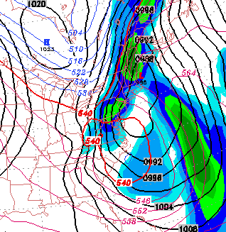
Still great uncertainty with the upcoming weekend, as the models vary in track and timing of a coastal storm that may affect us either Friday or Saturday. It does appear that colder temperatures are on their way for Sunday.
Even more interesting, the NOGAPS model has a major snowstorm for Sunday. Again, too early to tell.
I'll have a better handle on it tomorrow.
posted: Jan 31 2006 at 2:17 pm
[/weather/jan06] permanent link
Mon, 30 Jan 2006Upcoming Philadelphia Weather- Monday Eve Update
The latest GFS has combined with the NAM -- some rain for Tuesday. Somewhat colder, but still not wintery temperatures for the rest of the week.
As has been the case this winter, the medium range period changes from day to day, with little model consistency.
For the upcoming weekend- Today's GFS shows a big change from yesterday's model, with deep low pressure developing along the coastline on Saturday and rain changing to snow Saturday night. Too early to be confident about this.
posted: Jan 30 2006 at 8:29 pm
[/weather/jan06] permanent link
Upcoming Philadelphia Weather- Mon
The latest GFS has combined with the NAM -- some rain for Tuesday. Somewhat colder, but still not wintery temperatures for the rest of the week.
A cold front moves through on Friday night. The upcoming weekend looks to be mostly sunny but with fairly cold temperatures, as winter moves back in. The following week, a more typical winter pattern of very cold temperatures and possible snow at some point.
posted: Jan 30 2006 at 7:04 am
[/weather/jan06] permanent link
Sun, 29 Jan 2006Upcoming Weather for Tuesday
Once again, the GFS has flipped away from snow for our area, Monday night into Tuesday. The latest GFS again moves the precipitation offshore.
Interestingly, the NAM model has a significant rain storm for Tuesday-- a totally different scenario than that depicted by the GFS. (When was the last time the NAM was correct?)
I'll update tomorrow.
posted: Jan 29 2006 at 6:21 pm
[/weather/jan06] permanent link
Philly Weekend Weather Update- Sunday AM
Last night's GFS still has about 0.13 inches water falling this afternoon as rain showers, starting before 1 PM.
The same GFS model has very light wet snow showers before daybreak on Tuesday. Currently, it's expected that temperatures will be too warm for accumulation.
Sun 1/22: Cloudy with showers, after 1 PM. Mild. Temps in the 50s.
posted: Jan 29 2006 at 9:20 am
[/weather/jan06] permanent link
Sat, 28 Jan 2006Philadelphia Weekend Weather-Tues Snow Update
Some cloudiness is moving in today, with the warm air. For Sunday, the models are consistent with clouds in the afternoon with showers. QPF values for Sundays showers are about 0.10 inches water.
Once again, the GFS has flipped back with a coastal storm, close enough late Monday night to give us some snow, especially in NJ. Precipitation amounts look light in the Philadelphia area and even less to our north and west. The path of this storm has changed from each model run, so confidence is still not too high.
Sat 1/28: Partly sunny and mild. High 57.
Sun 1/29: Some sun very early, then becoming cloudy. Showers by early afternoon. High near 54.
posted: Jan 28 2006 at 4:30 pm
[/weather/jan06] permanent link
Philadelphia Weekend Weather- Sat
Some cloudiness is moving in today, with the warm air. For Sunday, the models are consistent with clouds in the afternoon with showers. QPF values for Sundays showers are about 0.10 inches water.
The inconsistency of the medium range models this winter again shows itself-- the storm previoulsy predicted for Tuesday is now too far off the coast to affect us.
Sat 1/28: Partly sunny and mild. High 57.
Sun 1/29: Some sun very early, then becoming cloudy. Showers in the afternoon. High near 54.
posted: Jan 28 2006 at 8:45 am
[/weather/jan06] permanent link
Fri, 27 Jan 2006Philly Weekend Weather- Fri
 The models continue to flip around and provide uncertainy beyond 2-3 days.
For the coming weekend, high pressure should bring mild temps and beautiful skies on Saturday. Low pressure approaching on Sunday will bring increasing clouds and showers in the afternoon (QPF=0.15 water) This low pressure is expected to shear off to our north.
The latest GFS run has a possible snow storm for Tuesday. Since there has been so much run to run inconsistency in the medium range time frame, I wouldn't dust off the snow shovels yet.
Sat 1/28: Sunny and mild. High 53.
Sun 1/29: Sunny very early, becoming cloudy. Showers in the afternoon. High near 52.
The models continue to flip around and provide uncertainy beyond 2-3 days.
For the coming weekend, high pressure should bring mild temps and beautiful skies on Saturday. Low pressure approaching on Sunday will bring increasing clouds and showers in the afternoon (QPF=0.15 water) This low pressure is expected to shear off to our north.
The latest GFS run has a possible snow storm for Tuesday. Since there has been so much run to run inconsistency in the medium range time frame, I wouldn't dust off the snow shovels yet.
Sat 1/28: Sunny and mild. High 53.
Sun 1/29: Sunny very early, becoming cloudy. Showers in the afternoon. High near 52.
posted: Jan 27 2006 at 12:16 pm
[/weather/jan06] permanent link
Philly Weekend Weather- Possible Snow Tues
The models continue to flip around and provide uncertainy beyond 2-3 days.
For the coming weekend, high pressure should bring mild temps and beautiful skies on Saturday. Low pressure approaching on Sunday will bring increasing clouds and a chance of a light shower. This low pressure is expected to shear off to our north.
The latest GFS run has a possible snow storm for Tuesday. Since there has been so much run to run inconsistency in the medium range time frame, I wouldn't dust off the snow shovels yet.
Sat 1/28: Sunny and mild. Temps in the upper 50s.
Sun 1/29: Sunny early, increasing clouds in the afternoon. Chance of a shower late in the afternoon. High near 50.
posted: Jan 27 2006 at 8:51 am
[/weather/jan06] permanent link
Thu, 26 Jan 2006Philly Weather Outlook- Thurs
The models continue to flip around and provide uncertainty in the medium ranger period. At times, it looks like winter will return; subsequent model runs have those trends fading, only to return again.
That said, the first full week of February looks like it will be cold and stormy. A possible snow storm around February 7th, instead of the 4th, is now shown in the models. Again, this winter has been exceedlingly hard to predict in the medium and long range, so I wouldn't dust off the snow shovels just yet.
For the coming weekend, high pressure should bring mild temps and beautiful skies on Saturday. Low pressure approaching on Sunday will bring increasing clouds and a chance of a light shower.
A significant rain storm for Monday evening, may change over to snow before daybreak on Tuesday.
Sat 1/28: Sunny and mild. Temps in the upper 50s.
Sun 1/29: Sunny early, increasing clouds in the afternoon. Chance of a shower late in the afternoon. High near 50.
posted: Jan 26 2006 at 6:35 pm
[/weather/jan06] permanent link
Tue, 24 Jan 2006Philly Weather Outlook- Wed
The storm for the Sunday-Monday period continues to shift in timing and position; latest GFS delays it again until Monday, with temps too warm for snow.
Cold weather will move in on Wednesday. High pressure and an upper ridge will bring very nice weather for Saturday into Sunday. Low pressure approaching from the southwest will bring rain on Monday. This weekend may be the last one that's very warm for next several weeks.
Sat 1/28: Sunny and mild. Temps in the upper 50s.
Sun 1/29: Sunny in the morning, increasing clouds in the afternoon. High near 60.
posted: Jan 24 2006 at 8:23 pm
[/weather/jan06] permanent link
Mon, 23 Jan 2006Weather Outlook into February - Monday Update
For the final week in January, things chill down quite a bit Wed through Friday, then a warm-up and beautiful weather for Saturday. Sunday looks interesting- a cold front comes through and a low develops along the coastline, possibly giving us snow Sunday afternoon. This storm, in the Sun-Monday time frame, has been hinted at for weeks.
The beginning of February does seem to suggest a big change in the weather pattern with temperatures getting colder and greater chances of snow, especially into the first full week.
posted: Jan 23 2006 at 5:19 pm
[/weather/jan06] permanent link
Sun, 22 Jan 2006Weather Outlook into February
For the past several weeks, the GFS has been predicting a change in the pattern beginning durin the time frame 2/1 through 2/3 The most recent models have backed away from this a bit, moving the pattern change to about 2/5.
Until then, the coming week looks cold (much colder than previously expected), but the latest GFS suggests warm conditions for next weekend.
Continued chance for the first few days in February, but cold weather and snow returns for the first complete week in February.
That said, today's weather is much colder than previously expected, which suggests not the highest of confidence in the long term outlook.
posted: Jan 22 2006 at 11:48 am
[/weather/jan06] permanent link
Philly Weekend Weather Update- Sunday AM
A low pressure system approaching rapidly from the southwest; clouds will be on the increase after 1 PM.
A period of cold weather will return this week, but the coming weekend is looking very mild.
Sun 1/22: Sunny in the morning. Then increasing cloudiness after 1 PM.
posted: Jan 22 2006 at 9:01 am
[/weather/jan06] permanent link
Fri, 20 Jan 2006Philly Weekend Weather Update- Fri Eve
The latest models downplay the showers and even the clouds for Saturday.
Sat 1/21: Partly to mostly cloudy. While there's a very slight chance of a brief shower mid day, most of the day will be dry. WINDY. High 57-61.
Sun 1/22: Sunny. High near 50.
posted: Jan 20 2006 at 11:09 pm
[/weather/jan06] permanent link
Philly Weekend Weather Update- Fri
The models continue to have mild conditions for the balance of the week. Low pressure, originally expected to give us rain on Saturday may shear off to our north and west, giving us just a chance of a light shower in the afternoon.
Sat 1/21: Mostly cloudy. A slight chance of a shower in the afternoon, but most of the day will be dry. WINDY. High 57-61.
Sun 1/22: Sunny. High near 49.
posted: Jan 20 2006 at 7:51 am
[/weather/jan06] permanent link
Thu, 19 Jan 2006Weekend Weather Outlook and Winter Returns in the Long Range
The models continue to have mild conditions for the balance of the week. Low pressure, originally expected to give us rain on Saturday may shear off to our north and west, giving us just a chance of a light shower in the afternoon.
The extended range GFS model has been consistently predicting a major weather change for the first week in February. Current rough details: rain changing to snow on Monday, 1/30 and a possible significant snowstorm on Wednesday into Thursday 2/3. Bitter cold temps to follow. It's aways off, but winter is coming back. I'll keep an eye on this.
Sat 1/21: Mostly cloudy. A slight chance of a shower in the afternoon, but most of the day will be dry. High 55.
Sun 1/22: Sunny. High near 49.
posted: Jan 19 2006 at 7:17 pm
[/weather/jan06] permanent link
Weekend Weather Outlook -Thurs
The models continue to have mild conditions for the balance of the week. Low pressure, originally expected to give us rain on Saturday may shear off to our north and west, giving us just a chance of a light shower in the afternoon.
Sat 1/21: Mostly cloudy. A chance of a shower in the afternoon. High 55.
Sun 1/22: Sunny. High near 49.
posted: Jan 19 2006 at 7:30 am
[/weather/jan06] permanent link
Wed, 18 Jan 2006Weather Update- Wednesday
Colder (but not cold) air will filter in today behind the front that moved through mid-day. Things are quiet through Friday.
Saturday, a low pressure system approaches bring rain showers during the day. Things clear out for Sunday. Temps remain above normal for now.
Sat 1/21: Cloudy with rain showers, especially in the afternoon. High near 50.
Sun 1/22: Mosty sunny and seasonably cold. High low to mid 40s.
posted: Jan 18 2006 at 3:57 pm
[/weather/jan06] permanent link
Tue, 17 Jan 2006Week and Weekend Weather Outlook -Tuesday
The weekend outlook:
The models continue to have mild conditions for the balance of the week. A heavy rain storm will affect us later this afternoon through mid day Wednesday. Temperatures move into the 40s and remain in the 40s and 50s as high temps for the balance of the week and weekend.
posted: Jan 17 2006 at 7:36 am
[/weather/jan06] permanent link
Mon, 16 Jan 2006Week Weather Outlook -Monday
The models continue to have mild conditions for the balance of the week. A heavy rain storm will affect us Tuesday night through Wednesday. Temperatures move into the 40s and remain in the 40s and 50s as high temps for the balance of the week and weekend.
The weekend outlook: mild with rain likely on Saturday. I'll update as the weekend approaches.
posted: Jan 16 2006 at 1:20 pm
[/weather/jan06] permanent link
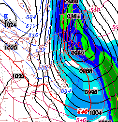
Sat, 14 Jan 2006Statistical Ensemble forecast for Saturday night
 Looking at the statistical ensemble for the GFS model (statistical ensemble is a set of 10 models, each with known biases; an average is taken to assess what the output would be like if we didn't know what errors existed in the operational format.) The Ensemble forecast suggests a near 100% chance of snow, and the QPF values suggest that the operational GFS is possibly understating the amount of precipitation tonight as snow.
posted: Jan 14 2006 at 9:36 am
[/weather/jan06] permanent link
Winter Weather Update 8 AM Saturday
 Last night's GFS (1 AM run of the model) still has snow, starting about 9PM and ending before daybreak Sunday. QPF values have been reduced to about 0.14 inches water. Considering ground temperatures, probably a coating up to 1.5 inches will accumulate over night.
posted: Jan 14 2006 at 9:22 am
[/weather/jan06] permanent link
Fri, 13 Jan 2006Winter Weather Update 11 PM
Tonight's GFS model continues to show wrap around moisture and cold air Saturday night- snow starting about 10PM. A total of 0.24 inches water (QPF) translates into 2-3 inches of snow by daybreak Sunday. Information about the models can be found at here.
As usual, the NAM model shows nothing happening Saturday evening. I'm ignoring the NAM model.
I'll update tomorrow.
posted: Jan 13 2006 at 11:09 pm
[/weather/jan06] permanent link
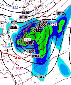
The GFS model has snow for Saturday night
The latest GFS model has precipitation continuing into much of Saturday night. Temperatures at the surface and at critical levels of the atmosphere drop below freezing about 10PM Saturday night. Several inches of snow is possible by daybreak Sunday, according to the latest GFS model.
The models have been inconsistent with this scenario. Confidence is not as high as usual.
b>Sat 1/14: Rain througout the day, continuing into the evening. Becoming WINDY. The latest GFS has rain changing to snow about 10 PM Saturday night. Several inches are possible by Sunday morning. High in the upper 40s, falling in the late afternoon into the 30s by evening.
Sun 1/15: A mix of sun and clouds windy and colder. High near 40.
I'll update this evening and tomorrow morning.
posted: Jan 13 2006 at 5:22 pm
[/weather/jan06] permanent link
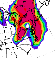
Probability of Snow for Late Saturday night
 Statistical breakdown for snow Saturday night. Orange is 70%.
posted: Jan 13 2006 at 7:46 am
[/weather/jan06] permanent link
Friday Weather Update for Philadelphia
 Low pressure off the coast Friday and Saturday will bring heavy rain Friday night and wrap around rain and showers through Saturday. Winds pick up late in the day on Saturday and temperatures will fall. It appears that some wrap around moisture and cold air aloft may result in a coating of snow before daybreak on Sunday.
Sat 1/14: Rain before daybreak will taper off to showers during the day. Mild temps initially, but will fall in the late afternoon as winds pick up. There's a chance of snow showers late at night, perhaps giving a coating of snow by Sunday morning.. High in the upper 40s, falling in the late afternoon.
Sun 1/15: A mix of sun and clouds windy and colder. High near 40.
Low pressure off the coast Friday and Saturday will bring heavy rain Friday night and wrap around rain and showers through Saturday. Winds pick up late in the day on Saturday and temperatures will fall. It appears that some wrap around moisture and cold air aloft may result in a coating of snow before daybreak on Sunday.
Sat 1/14: Rain before daybreak will taper off to showers during the day. Mild temps initially, but will fall in the late afternoon as winds pick up. There's a chance of snow showers late at night, perhaps giving a coating of snow by Sunday morning.. High in the upper 40s, falling in the late afternoon.
Sun 1/15: A mix of sun and clouds windy and colder. High near 40.
posted: Jan 13 2006 at 7:35 am
[/weather/jan06] permanent link
Thu, 12 Jan 2006Forget the snow - Thurs Eve Update
It's just going to be too warm for snow. Cold air doesn't come in until well after the storm departs. This has not been the usual winter and the model consistency this week has been anything but impressive.
Sat 1/14: Rain before daybreak will taper off during the morning. VERY WINDY. High temperature ealy in the day, but temps falling in the afternoon. There's a chance of snow flurries at night, perhaps giving a coating. High in the upper 40s, falling during the day.
Sun 1/15: A mix of sun and clouds still windy and seasonably cold. High near 39.
posted: Jan 12 2006 at 10:58 pm
[/weather/jan06] permanent link
Philly Weekend Weather - Thurs Update
The most recent GFS still advertising a 'negatively tilted' low pressure system to develop on the coast and move slowly from Friday night through Saturday night. Rain Friday night will reduce to light showers on Saturday, but wrap around moisture and negative tilt aloft will bring in cold air, causing a change to snow late Saturday into Saturday night. Some small accumulation is possible, but too early to call.
Sat 1/14:Rain early will turn to showers and then snow showers during the day on Saturday into Saturday evening. Possible small accumulation. VERY WINDY. High in the low 40s, falling to the 30s in the afternoon.
Sun 1/15: A mix of sun and clouds still windy and seasonably cold. High near 39.
posted: Jan 12 2006 at 7:00 am
[/weather/jan06] permanent link
Wed, 11 Jan 2006Philly Weekend Weather - Possible Rain-->Snow
A change in the forecast: The latest GFS has deep low pressure developing off the coast Friday night, with heavy rain into Saturday morning. Cold air filters in aloft on Saturday and wrap around moisture may fall as a period of snow on Saturday afternoon. Temps will be falling and surface temperatures will be warm, so it's difficult to judge about accumulation, if any. Cold air and windy conditions persist into Sunday.
Sat 1/14:Rain early will turn to showers and then snow showers during the day on Saturday. Possible small accumulation. VERY WINDY. High in the low 40s, falling to the 30s in the afternoon.
Sun 1/15: A mix of sun and clouds still windy and seasonably cold. High near 39.
posted: Jan 11 2006 at 8:41 pm
[/weather/jan06] permanent link
Disclaimer: I am not a meteorologist and provide this information as a hobby and for entertainment (mostly my own :-) . While attempts are made to predict the weather as best as I can, use at your own risk! I am NOT responsible for any direct or indirect consequential injury/damages due to your use of these forecasts. Always check the NWS Official Forecast for your final plans.
The weatherguy.net home page has been visited times since October 2003.