theweatherguy's website
Philadelphia Weekend Weather and Storm Forecasts

About this blog
theweatherguy's website,
"Thoughts and comments on Philadelphia Weather and Daily Life."
aka "theweatherguy"
![]()
Copy link for RSS feed
These are a few of my favorite links. Meteorology Glossary
Weather Archives:
May Jun Jul Aug Sept Oct Nov Dec
12: Jan Feb Mar Apr
May Jun Jul Aug Sept Oct Nov Dec
11: Jan Feb Mar Apr
May Jun Jul Aug Sept Oct Nov Dec
10: Jan Feb Mar Apr
May Jun Jul Aug Sept Oct Nov Dec
09: Jan Feb Mar Apr
May Jun Jul Aug Sept Oct Nov Dec
May Jun Jul Aug Sept Oct Nov Dec
07: Jan
Feb
Mar
Apr
May Jun
Jul
Aug
Sept
Oct
Nov Dec
06: Jan
Feb
Mar
Apr
May Jun
Jul
Aug
Sept
Oct
Nov
Dec
Commentary:
Miscellaneous
![]()
Sun, 28 Aug 2005
Philadelphia Weekend Weather Update
The NOGAPS model continues to predict that Katrina will move in to eastern Louisiana on Mnday, but currently has the intense rains going up to our west during the week, missing us.
Sun 8/21: Going with the NAM model here: Mostly cloudy with showers likely in the morning, perhaps some sun mid day, and thunderstorms a good bet in the afternoon. High 82. Humid.
 Still large differences between the GFS and NAM today. The NAM has us incredibly wet through Monday, just due to tropical flow and not from Katrina (yet). Hard to tell, but the GFS missed the showers and clouds that broke out in Cape May yesterday while the NAM was on the money. Will have to watch.
posted: Aug 28 2005 at 6:40 am
[/weather/august05] permanent link
Sat, 27 Aug 2005Philadelphia Weekend Weather For Sat 8/27 & Sun 8/28
The NOGAPS model, which accurately predicted Katrina crossing into the Gulph, now predicts a very strong Katrina to make landfall around Louisiana Monday morning and take its remnants further west before affecting us Tuesday into Wednesday with heavy rains.
Sat 8/27: Mostly sunny with occasional periods of clouds. High near 84. Increasing humidity.
Sun 8/21: Going with the NAM model here: Mostly cloudy with showers likely in the morning and thunderstorms a good bet in the afternoon. High 82. Humid. (Much more sun and drier if the GFS verifies.)
Jersey Shore: SSE winds will allow temps to be a bit cooler, but humidities on the increase. Otherwise, similar uncertainties exist to the Philadelphia Forecast.
Large differences today between the GFS and NAM for this weekend. The GFS has partly sunny skies and only a slight chance of showers through Sunday. The NAM has mostly cloudy conditions and and a high probability of showers on Sunday. Confidence in the forecast with such large differences is low. The GFS has not been too accurate with Katrina. The NOGAPS has done much better. My forecast will go with the NAM today.
posted: Aug 27 2005 at 7:00 am
[/weather/august05] permanent link
Fri, 26 Aug 2005Weekend Weather For Sat 8/27 & Sun 8/28
The NOGAPS model continues to forecast Katrina to cross Florida, redevelop and enter near Louisiana or Alabama. The latest NOGAPS run has the bulk of the remnants of Katrina in western PA by Tuesday, rather than eastern PA, but too early to be sure.
Sat 8/27: Partly sunny in the morning, and a mix of clouds and some sun in the afternoon. High near 83. Increasing humidity.
Sun 8/21: A considerable amount of clouds, but still some sun, and there may be light showers in the morning and more likely in the afternoon, according to the latest GFS. Details on timing of any showers not possible at this time. High near 82. Humid.
 Increases in moisture at various levels of the atmosphere will cause an increase in cloudiness as the weekend progresses. The latest models suggest the possibility of a few light showers on Sunday, but changeable skies with considerable cloudiness is likely
posted: Aug 26 2005 at 11:24 am
[/weather/august05] permanent link
Thu, 25 Aug 2005Weekend Weather For Sat 8/27 & Sun 8/28
The NOGAPS model continues to forecast Katrina to cross Florida, redevelop and enter near Louisiana or Alabama. Moisture will become entrained in stalled frontal boundary along the coast and a the remnants will redevelop as an extratropical coastal low, bringing heavy rain by Tuesday.
Sat 8/27: Partly sunny in the morning, with increasing clouds in the afternoon. High near 85. Increasing humidity.
Sun 8/21: A considerable amount of clouds and there may be showers in the morning, according to the latest GFS. Details not possible at this time. High near 87. Humid.
The forecast for the weekend continues to change. Moisture outflow from Katrina and the south will become entrained in several weak fronts that will shear to our north. More cloudiness is expected than previously thought, especially on Sunday.
posted: Aug 25 2005 at 9:56 pm
[/weather/august05] permanent link
Weekend Weather For Sat 8/27 & Sun 8/28
The GFS, as expected, has joined with the NOGAPS model regarding the path of tropical storm Katrina. Katrina is now expected to cross Florida and then move up the coast. Moisture from the storm may affect us as early as Sunday afternoon. Heavy rains possible on Monday.
Sat 8/27: Partly to mostly sunny and warm. High near 85. Increasing high clouds and humidity.
Sun 8/21: Partly cloudy/partly sunny. There's a chance of showers in the afternoon. Increased humidity. Details will depend on the moisture and track of Katrina which has changed in the past 12 hours.
Things can change rapidly when tropical storms are in the picture and, indeed, they have.
posted: Aug 25 2005 at 6:26 am
[/weather/august05] permanent link
Wed, 24 Aug 2005Weekend Weather For Sat 8/27 & Sun 8/28
Interesting weather for next Monday into Tuesday, as the current GFS has tropical storm Katrina moving up the coastline, giving us heavy rains here starting Monday night. This is an interesting storm to watch...I usually like the NOGAPS model for tropical storms and hurricanes, and the current NOGAPS has the tropical storm crossing FL and coming in near Louisiana. Will be interesting to watch what happens.
Sat 8/27: Sunny and warm. High near 85.
Sun 8/21: Continued sunny and warm. High near 87. Chance of a thunderstorm at late afternoon or night, as tropical moisture begins to move up the coast.
High pressure will continue to supress moisture to our south. Fair skies and dry weather through the weekend. That's the current outlook.
posted: Aug 24 2005 at 8:14 pm
[/weather/august05] permanent link
Tue, 23 Aug 2005Weekend Weather For Sat 8/27 & Sun 8/28
High pressure will continue to supress moisture to our south. Fair skies and dry weather through the weekend. That's the current outlook.
posted: Aug 23 2005 at 6:24 pm
[/weather/august05] permanent link
Sun, 21 Aug 2005Weekend Weather Update
 Following Friday's unforecast rain showers, the models did fairly well for the remainder of this past weekend -- the front went through with just a wind shift and a few clouds. Drier air is poised to move in on Monday and cooler temps on Tuesday. Next weekend, at least at this point, looks pretty good, with warmer temps returning by the weekend. Updates during the week.
posted: Aug 21 2005 at 7:03 pm
[/weather/august05] permanent link
Sat, 20 Aug 2005Weekend Weather Update
Sat 8/20: Following warm front passage, clouds will break for some sunshine. Warm and humid. High 90. Chance of a late day thunderstorm.
Sun 8/21: Cloudy early morning, becoming partly sunny, very hot and humid. High low 90s. Cold front comes through late afternoon, again with thunderstorms a possibility. (although the model POPS are low)
South Jersey Shore: Similar weather, somewhat cooler. Lingering front on Sunday night and Monday may delay clearing at the shore on Monday.
 The warm front has passed through and dewpoints are in the 70s again. The low level stratocumulus layer is expected to break for sunshine today. The NWS is forecasting a good chance of thunderstorms this afternoon (Sat), but the models have the chances of thunderstorms surprisingly low. The actual cold front is expected to move through late Sunday and may linger on the coastline.
posted: Aug 20 2005 at 7:21 am
[/weather/august05] permanent link
Fri, 19 Aug 2005Weekend Weather For Sat 8/20 & Sun 8/21
Sat 8/20: Following warm front passage, clouds will break for some sunshine. Warm and humid. High 90. Chance of a late day thunderstorm.
Sun 8/21: Cloudy early morning, becoming partly sunny, very hot and humid. High low 90s. Upper air cold front comes through late afternoon, again with thunderstorms a possibility.
A warm front will pass through on Friday...A wind shift front is expected to move through by early morning on Sunday, but the upper level front coming through Sunday night. Great uncertainty with this forecast, since the models didn't capture Friday's weather accurately at all.
posted: Aug 19 2005 at 5:51 pm
[/weather/august05] permanent link
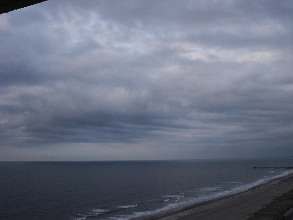
Low Confidence for this weekend's forecast
A major pattern change is in the works and the models are not capturing the warm front precipitation that has developed Thursday night and affecting us Friday morning. Neither the NAM, GFS or MM5 models predicted this precipitation. When the models are wrong in the short term, the longer term forecast is highly suspect.
I'll wait until later to try to clarify this weekend's forecast.
 The picture, taken yesterday at sunset, shows a classic cloud pattern of a warm front approaching.
posted: Aug 19 2005 at 8:18 am
[/weather/august05] permanent link
Weekend Weather For Sat 8/20 & Sun 8/21
Sat 8/20: Sunny and breezy and humid in the morning, then some cloudiness will move in later in the afternoon. Chance of showers at night. High near 90.
Sun 8/21: Cloudy in the morning, perhaps some lingering showers as the cold front moves off the coast. Becoming partly to mostly sunny, breezy in the afternoon. Less humid. High in the 80s. There is some question about the how fast the front will move through, which may affect the clearing, especially at the Jersey Shore.
A warm front will pass through on Friday...A signficant cold front is expected to move through by early morning on Sunday. The front may linger.
posted: Aug 19 2005 at 4:34 am
[/weather/august05] permanent link
Thu, 18 Aug 2005Weekend Weather For Sat 8/20 & Sun 8/21
Sat 8/20: Sunny and breezy and humid in the morning, then some cloudiness will move in later in the afternoon. Chance of showers at night. High near 90.
Sun 8/21: Cloudy in the morning, perhaps some lingering showers as the cold front moves off the coast. Becoming partly to mostly sunny, breezy in the afternoon. Less humid. High in the 80s. There is some question about the how fast the front will move through, which may affect the clearing, especially at the Jersey Shore.
A signficant cold front is expected to move through by early morning on Sunday.
posted: Aug 18 2005 at 5:41 pm
[/weather/august05] permanent link
Wed, 17 Aug 2005Weekend Weather For Sat 8/20 & Sun 8/21
Sat 8/20: Sunny for most of the day, warm and humid. Winds will pick up later in the day. High near 90. Some cloudiness possible late in the day as a cold front approaches.
Sun 8/21: Cloudy in the morning, perhaps some lingering showers as the cold front moves off the coast. Becoming partly sunny, breezy in the afternoon. Less humid. High in the 80s. The exact timing of the front will determine how cloudy it is the morning.
Things are clarifying for the weekend. The first evidence of a change to the Fall season will start this weekend, as a cold front moves through, either Saturday night or Sunday morning. Upper cyclonic flow will develop as high pressure builds in from Canada. Very clear and nice conditions following the weekend.
posted: Aug 17 2005 at 6:22 am
[/weather/august05] permanent link
Tue, 16 Aug 2005Weekend Weather For Sat 8/20 & Sun 8/21
Sat 8/20: Partly cloudy/party sunny with a chance of showers, especially late afternoon. High 85. Look for changes in this forecast.
Sun 8/21: Cloudy in the morning, becoming partly sunny in the afternoon. Still a chance of a shower. High 83. Look for changes in this forecast.
At this point, the forecast for the upcoming weekend is less than clear. A cold frontal system is expected to move through at some point on Friday through Saturday, but the latest GFS model has the front hanging up and either washing out or acting as a focus for showers. Will need to see how the next model runs handle this front.
posted: Aug 16 2005 at 6:20 am
[/weather/august05] permanent link
Sun, 14 Aug 2005Weekend Weather Update
South Jersey Shore: Similar weather as Philadelphia. High humidity and temps near 90. Any thunderstorms will probably wait until evening or night.
A cold front will approach slowly during the day and may hang up near us on Monday.
Sun 8/14: Mostly sunny, continued hot and very humid. Some increasing cloudiness may move in later in the afternoon. A good chance of thunderstorms early evening and through the night. High 95.
posted: Aug 14 2005 at 7:48 am
[/weather/august05] permanent link
Sat, 13 Aug 2005Weekend Weather Update
Sat 8/13: Mostly sunny, hot and humid. High 95+ with dewpoints in the very uncomfortable mid 70s. Chances of a thunderstorm are quite slight.
Sun 8/14: A bit with clouds than sunshine today as a low pressure system shears off to our north. High 94. Very humid, dewpoints near 75. A better chance of a thunderstorm or shower in the afternoon.
South Jersey Shore: Similar weather as Philadelphia. High humidity and temps in the 90s. Less of a chance of showers and fewer clouds than Philadelphia on Sunday.
 Latest GFS shears off the low and front a bit to our north on Sunday, although some increase in cloudiness and a better chance of a shower Very hot and humid through the weekend. Chance of late afternoon thundershowers each day.
posted: Aug 13 2005 at 8:57 am
[/weather/august05] permanent link
Fri, 12 Aug 2005Weekend Weather For Sat 8/13 and Sun 8/14
Sat 8/13: Partly sunny, hot and humid. High 95 with dewpoints in the very uncomfortable mid 70s.. Chance of an afternoon or evening thunderstorm.
Sun 8/14: Increasing clouds with more clouds than sunshine today as a low pressure system shears off to our north. High 90. Very humid, dewpoints near 75. A better chance of a thunderstorm or shower in the afternoon.
South Jersey Shore: Similar weather as Philadelphia. High humidity and temps in the 90s. Less of a chance of showers and fewer clouds than Philadelphia on Sunday.
Latest GFS shears off the low and front a bit to our north on Sunday, although some increase in cloudiness and a better chance of a shower Very hot and humid through the weekend. Chance of late afternoon thundershowers each day.
posted: Aug 12 2005 at 10:16 am
[/weather/august05] permanent link
Thu, 11 Aug 2005Weekend Weather For Sat 8/13 and Sun 8/14
Sat 8/13: Partly sunny, hot and humid. High 94. Chance of an afternoon or evening thunderstorm.
Sun 8/14: Partly sunny, hot and humid. High 93. Chance of an afternoon or evening thunderstorm.
Latest GFS shears off the low and front to our north on Sunday. Very hot and humid through the weekend. Chance of late afternoon thundershowers each day.
posted: Aug 11 2005 at 1:42 pm
[/weather/august05] permanent link
Wed, 10 Aug 2005Weekend Weather For Sat 8/13 and Sun 8/14
Sat 8/13: Partly sunny, hot and humid. High in the low 90s. Chance of an afternoon or evening thunderstorm.
Sun 8/14: Becoming mostly cloudy with a chance of showers or rain during the mid-day hours. Exact timing not certain at this time. The timing of this low pressure has changed radically over the past 24 hours, so look for further changes in the forecast.
For Friday and Saturday, Bermuda High pressure re-establishes itself over the weekend as weak cold fronts shear off to our north. Summery weather again with temps in the low 90s, high humidity and a daily chance of a shower or thunderstorm is the outlook, according to the current GFS. On Sunday, the current GFS has low pressure moving in from the west, resulting in showers during the day. Exact timing of this feature not able to be pinned down at this time.
posted: Aug 10 2005 at 4:08 pm
[/weather/august05] permanent link
Tue, 09 Aug 2005Weekend Weather For Sat 8/13 and Sun 8/14
Sat 8/13: Partly sunny, hot and humid. High in the low 90s. Chance of an afternoon or evening thunderstorm.
Sun 8/14: Partly sunny, hot and humid. High low 90s. Again, a slight chance of an afternoon or evening thunderstorm.
Bermuda High pressure re-establishes itself over the weekend as weak cold fronts shear off to our north. Summery weather again with temps in the low 90s, high humidity and a daily chance of a shower or thunderstorm is the outlook, according to the current GFS.
posted: Aug 09 2005 at 6:27 am
[/weather/august05] permanent link
Sun, 07 Aug 2005Weekend Weather Update
Sun 8/7: Mostly cloudy with showers developing in the morning. Scattered showers (exact timing can't be determined) and clouds mixed with bright spots for today. Chance of heavier thunderstorms this evening.
South Jersey Shore: High pressure will keep showers to our west and give partly sunny skies for most of Sunday. The high pressure ridge breaks down Sunday night, allowing showers to move in.
Warm moist air is already moving back into Philadelphia. Showers are forming dynamically this morning west and south and should move into our area this later this morning. A mix of clouds, some sun and showers is likely for today as tropical air returns.
posted: Aug 07 2005 at 7:28 am
[/weather/august05] permanent link
Sat, 06 Aug 2005Weekend Weather Update
Sat 8/6: Cloudy, with showers possible in the early morning, then partly sunny Then cloudy late afternoon. High in the low to mid 80s. Showers possible late afternoon and at night.
Sun 8/7: Mostly cloudy with a chance of showers, especially in the morning. Some partial clearing in the afternoon. Becoming more humid. High in the mid 80s.
Shore: Partly cloudy for much of the day. Sun burns through in the afternoon, then clouds return with showers tonight. High near 80. Uncertain forecast for Sunday, but clouds and showers in the morning appears likely.
As mentioned yesterday, there was uncertainty about how far south the front would go before stalling. The front has stalled just south of us and is expected to return as a warm front Sunday. The MM5 and RUC models have significant cloud cover today, with perhaps a bit of sun. There's a chance of showers later today, tonight and Sunday as the front returns and southerly flow develops.
posted: Aug 06 2005 at 9:56 am
[/weather/august05] permanent link
Fri, 05 Aug 2005Weekend Weather For Sat 8/6 and Sun 8/7
Sat 8/6: Cloudy, with showers possible in the early morning, becoming partly sunny. Less humid, with highs in the mid to upper 80s. Position of the front and the amount of clouds is uncertain at this time.
Sun 8/7: A bit more clouds, especially in the afternoon. Continued less humid (than Friday) and temps in the mid to upper 80s. Exact amount of cloud cover unclear at this time. We need to watch the position of the stalled frontal boundary.
Shore: Northeasterly flow will keep things cooler at the shore. Temps in the low to mid 80s. We have to watch the amount of clouds with this northeasterly flow.
Looking at the latest models, there is some question about the front and moisture on Saturday. The RUC model has showers early Saturday morning and the latest NAM and GFS have a fair amount of clouds around on Saturday. We need to watch this. The earlier forecast of clearing could fizzle out.
posted: Aug 05 2005 at 1:14 pm
[/weather/august05] permanent link
Weekend Weather For Sat 8/6 and Sun 8/7
Sat 8/6: Cloudy in the early morning, becoming partly sunny. Less humid, with highs in the mid to upper 80s.
Sun 8/7: A bit more clouds, especially in the afternoon. Continued less humid (than Friday) and temps in the mid to upper 80s. Exact amount of cloud cover unclear at this time.
Shore: Northeasterly flow will keep things cooler at the shore. Temps in the low to mid 80s. We have to watch the amount of clouds with this northeasterly flow.
The weak front is still expected to pass through our area on Friday. A dew point change and a reduction of temperature is expected with the air mass behind the front. The weak frontal boundary will be just to our south, as high pressure builds in. The location of the front will allow some cloudiness to mix through with sun at times Saturday and Sunday.
posted: Aug 05 2005 at 8:53 am
[/weather/august05] permanent link
Wed, 03 Aug 2005Weekend Weather For Sat 8/6 and Sun 8/7
Sat 8/6: Becoming mostly sunny after some lingering morning clouds. High in the mid to upper 80s. Less humid.
Sun 8/7: Sun most of the day, perhaps some clouds moving in late in the afternoon. High in the mid to upper 80s.
A weak front will push through the area on Friday night, clearing the coast early Saturday morning. Little precipitation. High pressure will build in for Saturday and most of Sunday, giving us mostly sunny skies and somewhat cooler temps and lower dewpoints. Another weak disturbance will approach from the south late Sunday afternoon or evening.
posted: Aug 03 2005 at 5:51 pm
[/weather/august05] permanent link
Tue, 02 Aug 2005Weekend Weather For Sat 8/6 and Sun 8/7
Sat 8/6: Partly cloudy. Temps in the upper 80s.
Sun 8/7: Partly cloudy. Temps in the upper 80s.
Right now, partly cloudy conditions with a chance of a shower late in the day, is the forecast for the weekend. Updates later in the week.
posted: Aug 02 2005 at 5:46 am
[/weather/august05] permanent link
Disclaimer: I am not a meteorologist and provide this information as a hobby and for entertainment (mostly my own :-) . While attempts are made to predict the weather as best as I can, use at your own risk! I am NOT responsible for any direct or indirect consequential injury/damages due to your use of these forecasts. Always check the NWS Official Forecast for your final plans.
The weatherguy.net home page has been visited times since October 2003.