theweatherguy's website
Philadelphia Weekend Weather and Storm Forecasts

About this blog
theweatherguy's website,
"Thoughts and comments on Philadelphia Weather and Daily Life."
aka "theweatherguy"
![]()
Copy link for RSS feed
These are a few of my favorite links. Meteorology Glossary
Weather Archives:
May Jun Jul Aug Sept Oct Nov Dec
12: Jan Feb Mar Apr
May Jun Jul Aug Sept Oct Nov Dec
11: Jan Feb Mar Apr
May Jun Jul Aug Sept Oct Nov Dec
10: Jan Feb Mar Apr
May Jun Jul Aug Sept Oct Nov Dec
09: Jan Feb Mar Apr
May Jun Jul Aug Sept Oct Nov Dec
May Jun Jul Aug Sept Oct Nov Dec
07: Jan
Feb
Mar
Apr
May Jun
Jul
Aug
Sept
Oct
Nov Dec
06: Jan
Feb
Mar
Apr
May Jun
Jul
Aug
Sept
Oct
Nov
Dec
Commentary:
Miscellaneous
![]()
Sat, 31 Jul 2010
Philadelphia Weekend Weather Forecast -Fri PM
High pressure on Saturday will give way to weak disturbances moving along a weak frontal boundary, giving us a chance of showers and thunderstorms on Sunday.
At least for the first days of August, we'll have temps in the 80s, although there may be some unsettled weather on Wednesday as another front moves through.
Sat 7/31: Sunny and warm. High 85.
Sun 8/1: Considerable cloudiness with showers and thunderstorms possible in the afternoon. High 81
posted: Jul 31 2010 at 12:38 am
[/weather/jul10] permanent link
Thu, 29 Jul 2010Philadelphia Weekend Weather Forecast -Thurs AM
Some heat relief on the way-- Following a cold front passage today (Thurs), the first half of the weekend will have sunshine and more seasonable temperatures. The front, which will be not too far to our south will allow impulses to move along it, giving us a chance of showers and thunderstorms on Sunday.
At least for the first days of August, we'll have temps in the 80s, although there may be some unsettled weather on Wednesday.
Sat 7/31: Sunny and warm. High 87.
Sun 8/1: Considerable cloudiness with showers and thunderstorms. High 81
posted: Jul 29 2010 at 7:49 am
[/weather/jul10] permanent link
Sun, 25 Jul 2010Philadelphia Weekend Weather Forecast -Sun PM
A front moving through is setting off showers and thunderstorms, even though the GFS and NAM have POPS less than 40%.
The NAM MOS had less than a 20% chance of showers/thunderstorms, althought last night's NAM FOUS data did suggest some precip for this afternoon. That said, there have been several thunderstorms over the past few weeks that weren't accurately predicted by the models. So what seemed like a tranquil transitional day from the heat wave has turned cloudy and wet.
Sun 7/25: Mostly sunny hot. Thunderstorms and showers in the afternoon.
posted: Jul 25 2010 at 3:08 pm
[/weather/jul10] permanent link
Philadelphia Weekend Weather Forecast -Sun PM
A front moving through is setting off showers and thunderstorms, even though the GFS and NAM have POPS less than 40%
Sun 7/25: Mostly sunny hot. Thunderstorms and showers in the afternoon.
posted: Jul 25 2010 at 2:17 pm
[/weather/jul10] permanent link
Thu, 22 Jul 2010Philadelphia Weekend Weather Outlook -Thurs PM
A southwesterly flow of hot and very humid air will be with us over the weekend. A weak front will pass through late Saturday night, bringing less humidity but still hot temps.
The latest GFS MOS forecast for Philadelphia has a high of 101 for Saturday; the NAM MOS has a high of 97.
Sat 7/24: Sunny, very hot and humid. Slight chance of a thunderstorm, late. High 97-100.
Sun 7/25: Mostly sunny hot, a bit less humid. High 96.
posted: Jul 22 2010 at 10:18 pm
[/weather/jul10] permanent link
Wed, 21 Jul 2010Philadelphia Weekend Weather Outlook -Wed PM
A southwesterly flow of hot and very humid air will be with us over the weekend. A weak front will pass through late Saturday.
Sat 7/24: Sunny, hot and humid. Slight chance of a thunderstorm, late. High 97.
Sun 7/25: Mostly sunny hot, a bit less humid. High 93.
posted: Jul 21 2010 at 11:32 pm
[/weather/jul10] permanent link
Thu, 15 Jul 2010Philadelphia Weekend Weather Outlook -Thur PM
A southwesterly flow of hot and very humid air on Friday will be replaced by a slightly less humid flow as a weak "cold" front (actually a wind shift/dew point line) moves through our area before daybreak on Saturday. There was some concern that the front would stall over us, but it now looks like it will stall and dissipate just to our south, affecting Delaware. Slightly drier air moves in on Sunday, but it will still be in the 90's
Sat 7/17: A thunderstorm possible before daybreak, then mostly sunny, hot and a bit less humid. Slight chance of a thunderstorm, but most places dry. High 95.
Sun 7/18: Mostly sunny hot, a bit less humid. High 93.
posted: Jul 15 2010 at 6:03 pm
[/weather/jul10] permanent link
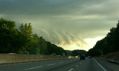
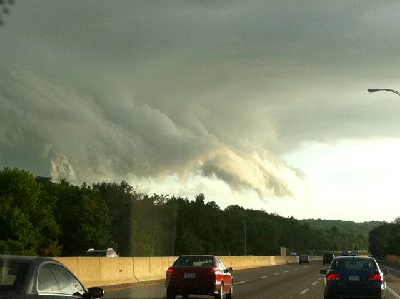
Sat, 10 Jul 2010Isolated Thunderstorm with Virga Captured!
Here are some pictures of the northwest side of an isolated, slow moving thunderstorm seen about 7:30PM near Fort Washington, PA yesterday. The downdraft is bringing clouds and rain to toward the ground. This thunderstorm was moving from SE to NNW and this was the advancing edge.

![]()
posted: Jul 10 2010 at 7:52 pm
[/weather/jul10] permanent link
Philadelphia Weekend Weather Forecast -Sat AM
I didn't have time to do much weather this week. Clearly, things have changes since my forecast on Wednesday. It's raining out!
The "cold" front is moving through now (Sat morning) instead of this afternoon. Much needed rain is falling and will likely continue through the mid-day hours, tapering and ending during the later afternoon. The cold front is really a wind-shift line and change in dewpoint. Temps return to the 90s tomorrow.
Sat 7/10: Cloudy with rain, tapering to showers during the afternoon. High 79-81
Sun 7/11: Mostly sunny, very warm, somewhat humid. High 90.
Solar Discussion July: Solar Cycle 24 is underway, although the increase in sunspot activity has fallen below predicted values at this stage of the cycle. Solar flux remains low, as does sunspot number. What has changed is the velocity of the solar wind. The solar wind was very quiet last summer, with speeds around 300 Km/sec. This year, solar wind values are much higher, in the 400-700 km/sec range. While solar wind is associated with coronal holes, not only flares and sunspots, this appears to be measurably increased this year. Are increases in solar wind associated with less cloud cover, less rain, droughts and heat waves? It's not clear, although there are theories making this association, specifically that the higher solar wind reduces high energy cosmic ray seeding of clouds. When was the last heat wave on July 4th? 11 years ago. What's the average solar cycle length? 11 years. Not scientific, but these drought and heat cycles seem to go in cycles of this length.
Back in April I took a temperature-neutral approach to this summer's climate. I'm still there. What I do think we might begin to see is a continuing decrease in precipitation, both with the end of the El Nino and the increase in solar activity. Perhaps we're seeing the beginning of a drought pattern? Stay tuned.
posted: Jul 10 2010 at 9:27 am
[/weather/jul10] permanent link
Wed, 07 Jul 2010Philadelphia Weekend Weather Outlook -Wed PM
The Bermuda high that gave us the record temps will move east and a cold front will move through Saturday afternoon bringing more tolerable temperatures and a chance of thunderstorms Saturday afternoon. As has been the recent trend, the thunderstorms that develop may weaken as they move eastward over Philadelphia and NJ. They are unlikely to significantly lessen the local dry conditions.
Sat 7/10: Partly cloudy/sunny, warm, very humid. Chance of thunderstorms in the afternoon. High 85.
Sun 7/11: Mostly sunny warm, less humid. High 89.
Solar Discussion July: Solar Cycle 24 is underway, although the increase in sunspot activity has fallen below predicted values at this stage of the cycle. Solar flux remains low, as does sunspot number. What has changed is the velocity of the solar wind. The solar wind was very quiet last summer, with speeds around 300 Km/sec. This year, solar wind values are much higher, in the 400-700 km/sec range. While solar wind is associated with coronal holes, not only flares and sunspots, this appears to be measurably increased this year. Are increases in solar wind associated with less cloud cover, less rain, droughts and heat waves? It's not clear, although there are theories making this association, specifically that the higher solar wind reduces high energy cosmic ray seeding of clouds. When was the last heat wave on July 4th? 11 years ago. What's the average solar cycle length? 11 years. Not scientific, but these drought and heat cycles seem to go in cycles of this length.
Back in April I took a temperature-neutral approach to this summer's climate. I'm still there. What I do think we might begin to see is a continuing decrease in precipitation, both with the end of the El Nino and the increase in solar activity. Perhaps we're seeing the beginning of a drought pattern? Stay tuned.
posted: Jul 07 2010 at 5:31 pm
[/weather/jul10] permanent link
Sun, 04 Jul 2010Philadelphia Weather Outlook -Sun PM
Well, things have warmed up, as have the latest MOS forecasts. Things get pretty bad here on Tuesday and Wednesday, as temps approach 98-100 and dewpoints move into the mid 60s
Mon 7/5: Sunny, hot and increasingly humid. High 98.
Solar Discussion July- The Solar Cycle 24 is underway, although the increase in sunspot activity has fallen below predicted values at this stage of the cycle. Solar flux remains low, as does sunspot number. What has changed is the velocity of the solar wind. The solar wind was very quiet last summer, with speeds around 300 Km/sec. This year, solar wind values are much higher, in the 400-700 km/sec range. While solar wind is associated with coronal holes, not only flares and sunspots, this appears to be measureably increased this year. Are increases in solar wind associated with less cloud cover, less rain, droughts and heat waves? It's not clear, although there are theories making this association, specifically that the higher solar wind reduces high energy cosmic ray seeding of clouds. When was the last heat wave on July 4th? 11 years ago. What's the average solar cycle length? 11 years. Not scientific, but these drought and heat cycles seem to go in cycles of this length.
Back in April I took a temperature-neutral approach to this summer's climate. I'm still there. What I do think we might begin to see is a continuing decrease in precipitation, both with the end of the El Nino and the increase in solar activity. Perhaps we're seeing the beginning of a drought pattern? Stay tuned.
posted: Jul 04 2010 at 7:20 pm
[/weather/jul10] permanent link
Philadelphia Weekend Weather Forecast -Sun AM
The latest models have lowered the high temps a bit.
A Bermuda high will set up a southwesterly surface flow of increasingly warm, then increasingly hot air for the weekend and into next week. There are differences in the models regarding high temperatures and the amount of moisture (dew points), but the general range will be 93-98. As hot as the temps will be, the dew point may not get past the mid 60s, sparing us from an extreme heat experience.
Sun 7/4: Sunny, hot and more humid. High 93.
Mon 7/5: Sunny, hot and increasingly humid. High 96.
posted: Jul 04 2010 at 8:35 am
[/weather/jul10] permanent link
Sat, 03 Jul 2010Philadelphia Weekend Weather Forecast -Sat PM
A Bermuda high will set up a southwesterly surface flow of increasingly warm, then increasingly hot air for the weekend and into next week. There are differences in the models regarding high temperatures and the amount of moisture (dew points), but the general range will be 95-100. As hot as the temps will be, the dew point may not get past the mid 60s, sparing us from an extreme heat experience.
Sun 7/4: Sunny, hot and more humid. High 95.
Mon 7/5: Sunny, hot and increasingly humid. High 97.
posted: Jul 03 2010 at 6:50 pm
[/weather/jul10] permanent link
Fri, 02 Jul 2010Philadelphia Weekend Weather Forecast -Fri PM
A Bermuda high will set up a southwesterly surface flow of increasingly warm, increasingly hot humid air for the weekend.
Sat 7/3: Sunny, warm. High near 89
Sun 7/4: Sunny, hot and increasingly humid. High 95.
posted: Jul 02 2010 at 9:58 pm
[/weather/jul10] permanent link
Disclaimer: I am not a meteorologist and provide this information as a hobby and for entertainment (mostly my own :-) . While attempts are made to predict the weather as best as I can, use at your own risk! I am NOT responsible for any direct or indirect consequential injury/damages due to your use of these forecasts. Always check the NWS Official Forecast for your final plans.
The weatherguy.net home page has been visited times since October 2003.