theweatherguy's website
Philadelphia Weekend Weather and Storm Forecasts

About this blog
theweatherguy's website,
"Thoughts and comments on Philadelphia Weather and Daily Life."
aka "theweatherguy"
![]()
Copy link for RSS feed
These are a few of my favorite links. Meteorology Glossary
Weather Archives:
May Jun Jul Aug Sept Oct Nov Dec
12: Jan Feb Mar Apr
May Jun Jul Aug Sept Oct Nov Dec
11: Jan Feb Mar Apr
May Jun Jul Aug Sept Oct Nov Dec
10: Jan Feb Mar Apr
May Jun Jul Aug Sept Oct Nov Dec
09: Jan Feb Mar Apr
May Jun Jul Aug Sept Oct Nov Dec
May Jun Jul Aug Sept Oct Nov Dec
07: Jan
Feb
Mar
Apr
May Jun
Jul
Aug
Sept
Oct
Nov Dec
06: Jan
Feb
Mar
Apr
May Jun
Jul
Aug
Sept
Oct
Nov
Dec
Commentary:
Miscellaneous
![]()
Sat, 11 Feb 2006
Winter Storm Update- 10:30 PM Update
The new NAM and GFS model data has become available. Both models have raised the QPF again during the 1AM-7AM time frame, from 0.30 to 0.50 inches water. Storm totals are close to .90 inches water again for both models.
Temperatures remain somewhat around freezing (32.5 here) and the water to snow ratio for much of the snowfall has been 1:10 or less so far. That ratio will increase from 1 AM to 7AM as temperatures drop into the low 20s. Winds are expected to be intense by morning.
There are also areas of increased precipitation, localized, just to our west due to localized increased lift("frontogenic forcing"). Some areas will have increased amounts of snow, especially Chester county and areas of central NJ.
For Philadelphia, my best guess at this time is now 7-9 inches by mid morning, when most of the snow will be ending. At this point, exact storm totals are academic-- We're NOT talking about a surprise 20 inch snowfall, nor are we talking about a 4 inch fizzler.
I'll update tomorrow morning.
posted: Feb 11 2006 at 10:50 pm
[/weather/feb06] permanent link
Winter Storm Update- 5 PM Update- Lowering Snow Totals!
I've looked at the 1PM NAM and GFS data. It seems I'm going to have to lower my snow totals prediction.
The QPF values have declined to 0.70 inches water on both the NAM and GFS models. Additionally, temperatures at the surface are higher than I had expected at this time and the amount of dynamic cooling hasn't offset the milder than expected NE flow.
The latest models show the temperature not going below 32 until 7 or 8 PM in Philadelphia, so some accumulation will be lost. With a much wetter snow, the ratio here will likely be 1:10 instead of 1:15. The best guess at this time is now 6-8 inches.
The newer model runs will be out this evening between 9:45 and 10:45 and I'll update before 11 PM.
posted: Feb 11 2006 at 5:12 pm
[/weather/feb06] permanent link
Winter Storm Update- Morning Update 10:45AM
The GFS just became available and the NAM and GFS very similar at this time. QPF values for the GFS approach 0.93 inches with similar time frames as the NAM model. With this model run, the NAM which had been half the predicted amount, now exceeds the GFS.
Based on a water ratio of 1:15, I'm predicting 12-14 inches of snow for Philadelphia when all is said and done Sunday morning. More snow in NJ.
Sat 2/11: Cloudy during much of the day, snow starting mid to late afternoon. About an inch by 6 PM. High 37.
Sun 2/12: Snow tapering off towards noon, then cloudy windy and cold. High 28. Total accumulations as per discussion above.
Updates, as necessary, later. Next model runs of any great significance will be later this evening. I'll update tonight.
posted: Feb 11 2006 at 10:51 am
[/weather/feb06] permanent link
Winter Weather Update- 9 AM Sat- NAM has higher snow totals!
This morning's NAM data just became available. Total QPF value has increased to 1.05 inches water. Temps below freezing will result in snow totals in excess of 14 inches for Philadelphia.
This morning's NAM has fallen directly in line with last night's GFS model. Some light snow starting early to mid afternoon. Only an inch possible before 7 PM. HEAVY snow tonight into Sunday morning. Total snow about 14+ inches.
I'll update with the new GFS data that will become available about 10:45 AM.
posted: Feb 11 2006 at 9:25 am
[/weather/feb06] permanent link
Winter Storm Update- Early Morning Update 7AM
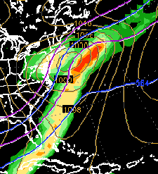 The 1AM reruns of the NAM and GFS models had remarkably similar results. QPF values of 0.78 and 1.01 inches of water respectively. The NOGAPS depiction is the graphic on the left.
With much of the precipitation arriving with colder temperatures at night, I'm raising the ratio of snow to water from 1:12 to 1:17. This would give us a snowfall of 12-14 inches in the immediate Philadelphia area, with up to 18 inches in parts of NJ.
There are still differences in the start time for the snow. The GFS has about 1-2 inches before nightfall, the NAM has virtually nothing starting until about 5 or 6 PM. We'll have to see about that. Sometimes, the warm advection before a storm occurs earlier than the models show. Othertimes, the air is so dry that little snow hits the ground, evaporating for several hours aloft.
Sat 2/11: Cloudy during much of the day, snow starting mid to late afternoon. A coating to an inch by 6 PM. High 30.
Sun 2/12: Snow tapering off towards noon, then cloudy windy and cold. High 28. Total accumulations as per discussion above.
The next NAM model output will be available between 9:30 and 10; the 24 hour products of the GFS might be available as early as 10:30 this morning. I'll update later.
The 1AM reruns of the NAM and GFS models had remarkably similar results. QPF values of 0.78 and 1.01 inches of water respectively. The NOGAPS depiction is the graphic on the left.
With much of the precipitation arriving with colder temperatures at night, I'm raising the ratio of snow to water from 1:12 to 1:17. This would give us a snowfall of 12-14 inches in the immediate Philadelphia area, with up to 18 inches in parts of NJ.
There are still differences in the start time for the snow. The GFS has about 1-2 inches before nightfall, the NAM has virtually nothing starting until about 5 or 6 PM. We'll have to see about that. Sometimes, the warm advection before a storm occurs earlier than the models show. Othertimes, the air is so dry that little snow hits the ground, evaporating for several hours aloft.
Sat 2/11: Cloudy during much of the day, snow starting mid to late afternoon. A coating to an inch by 6 PM. High 30.
Sun 2/12: Snow tapering off towards noon, then cloudy windy and cold. High 28. Total accumulations as per discussion above.
The next NAM model output will be available between 9:30 and 10; the 24 hour products of the GFS might be available as early as 10:30 this morning. I'll update later.
posted: Feb 11 2006 at 7:10 am
[/weather/feb06] permanent link
Disclaimer: I am not a meteorologist and provide this information as a hobby and for entertainment (mostly my own :-) . While attempts are made to predict the weather as best as I can, use at your own risk! I am NOT responsible for any direct or indirect consequential injury/damages due to your use of these forecasts. Always check the NWS Official Forecast for your final plans.
The weatherguy.net home page has been visited times since October 2003.