Update Wed 02/01 @ 10:55 AM — I don’t see any snowstorms in the next 10 days. The one chance, this Sunday into Monday, has fizzled even more—
NAEFS statistical “mode” forecast for Monday at 4 AM. Dip in the jet is minimal, not cold enough. (Click on image for a larger view.)
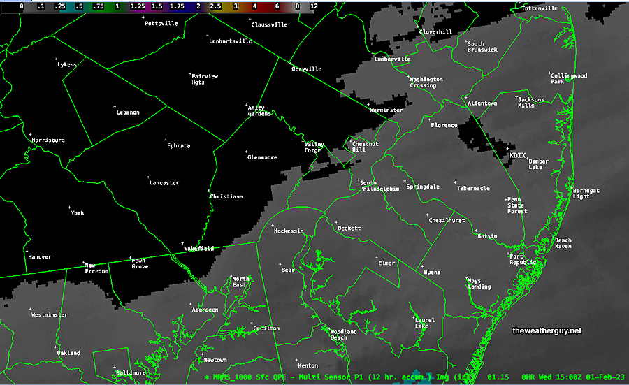
Wed 10:51 AM Forecast Review — We had that brief coating of snow last night. Some of last night’s models (HRRR, NAM) were pushing the the light coating only into NJ.
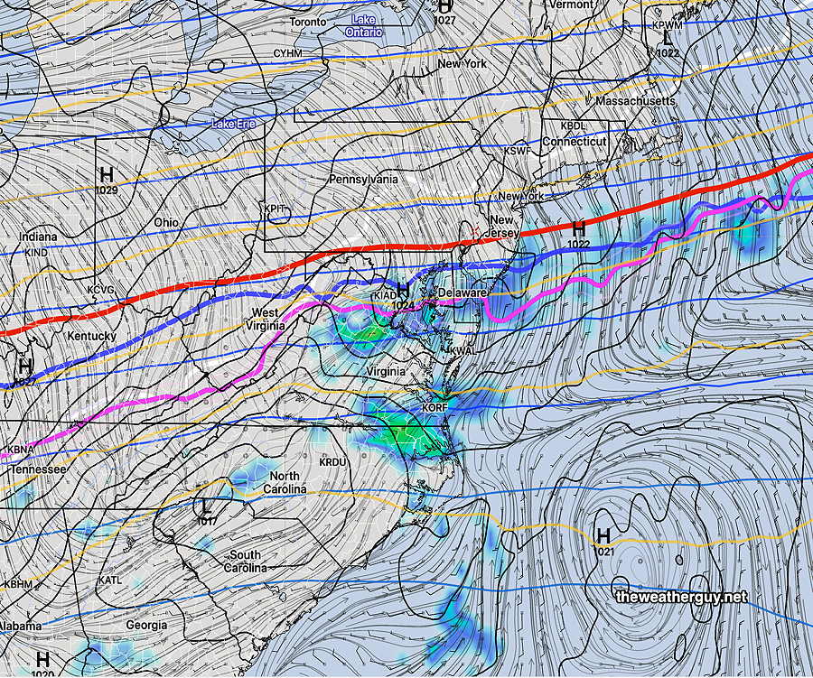
MRMS: Where was there a coating last night. Predicted Maxima didn’t occur in NJ, but further south. (Click on image for a larger view.)
The NBM was late to pick up on any snow coating. The Canadian HRDPS (updated recently) has been pretty good lately and it’s why I included its graphic yesterday. Perhaps it over-estimated snowfall somewhat but the coverage seems pretty good.
Update Tue 1/31 10:45 PM — Tonight’s models have the already minimal dusting very scattered west of the Delaware river with any coating most likely in NJ. NBM model has only 60% chance of 0.10 inches of snow.
Several models have joined in with forecasting a light coating of snow ending around daybreak to 8 AM Wednesday. (The current NBM stands out as forecasting no snow accumulation.)
Here’s the latest Canadian HRDPS forecast —
Today’s 18z HRDPS shows a possible coating of snow by Wednesday morning. Temperatures will drop below freezing and it may be slippery out early in the morning. (Click on image for a larger view.)
Temperatures rise well above freezing and there won’t be much left by late morning.
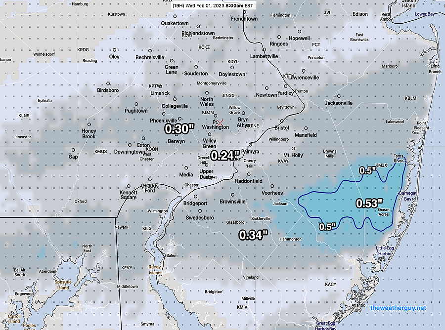
Update Tue 01/31 @ 4:32 PM — Just a quick update…latest ECMWF and NAM-NEST are forecasting very light snow between 3 AM and 6 AM Wednesday morning. A light dusting possible less than 0.20 inches, especially in South Jersey.
NAM-NEST snow-rain at 6 AM (Click on image for a larger view.)
Who Predicted This Wet Snow?
Update Tue 01/31 @ 3:20 PM — So, I’ve been “off-duty” the past two days and I haven’t done a daily forecast, just a jet stream over-view yesterday. But I’m pretty sure I heard the forecast on the radio— ”some showers possible in the morning’. That was about it.
We’ve had very light, wet, non-accumulating snow falling for the past 4-5 hours.
So folks, this is going to have to be a Retroactive Forensic Forecast to answer the question, “what the heck is going on??”
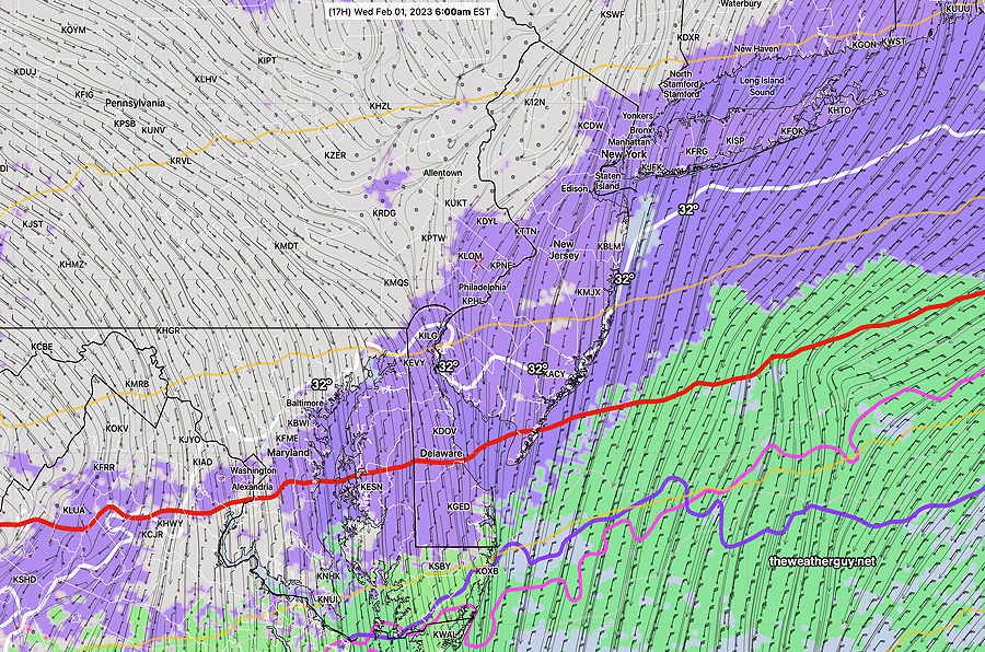
Basically a cold front went through overnight, as had been forecast. Looking back at last night’s models, several were hinting for the front to stall just to our south and several waves of low pressure have apparently formed along the stalling front. That said, this morning’s HRRR had light rain, not light wet snow, and ending earlier than it has.
This morning’s GFS was not capturing this afternoon’s wet snow in its forecast, although the wavy nature of the thermal contours is apparent—
Today’s 12z GFS shows the 800 and 900mb freezing temperatures (blue and violet) are quite wavy, suggesting the weak waves of low pressure. The isobars just south of us are all “baggy” which also shows the very weak low pressure waves. Also notice the 32º surface temperature line (faint white) is north of us. It doesn’t have to be freezing outside to have snow. (Click on image for a larger view.)
I’ll have to check to see if there are any more surprises in store for us. Stay tuned.
Transitioning Jet Flow
#weather #paweather #wx #pawx #philadelphia
Useful Weather Link from the NWS—
The NWS has an Impact Based Decision Support Services(IDSS) websitethat provides detailed and up to date hour-by-hour weather information and forecasts. There’s a button that allows you to save a specific location URL to your web browser Favorites or Bookmarks.
Excellent! Better than most weather mobile apps!
A split jet flow, flat in our area, will transition to a trough by Friday. Most systems will pass by to our south and to our north through Friday.
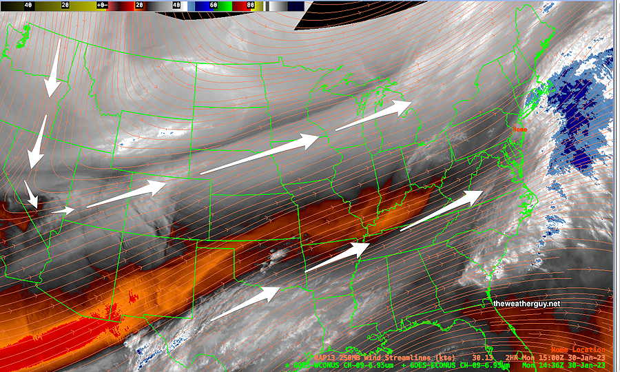
Current Water Vapor Image shows jet positions—
Monday Morning Satellite Water Vapor image (mid level) shows two jet streams and a flat configuration over our area on Monday morning. (Click on image for a larger view.)
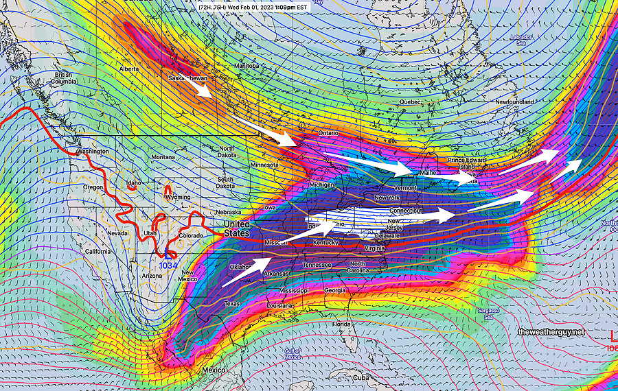
By Wednesday, things begin to change. Here’s the NAEFS model showing more detail at jet stream wind level as it transitions on Wednesday —
NAEFS Wednesday 250 mb (jet stream level) winds Strong jet streak over Pennsylvania (white color code) (Click on image for a larger view.)
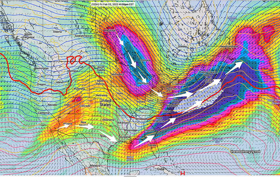
By Friday, we’re under an upper level trough with cold air—
NAEFS 250 mb wind Friday forecast shows full transition into trough over our area. (Click on image for a larger view.)
No large storms expected to form here this week and no snowstorms expected here within in the next 10 days.
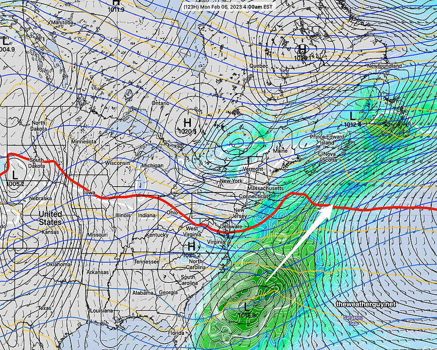
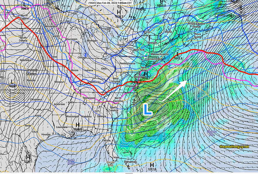
Update Sun 01/29 @ 9:26 PM — Just an update on the snow potential, or lack thereof. As mentioned over the past week, the period between Feb 2 and Feb 6th might hold promise for snow lovers.
Alas, not the case. Our best bet was Sunday night into next Monday (the 6th) and it’s going to be too warm for snow
Here’s the latest NAEFS showing coastal low pressure brushing us, but temperatures are too warm here for snow —
NAEFS shows critical temperatures too warm for snow. (Click on image for a larger view.)
Go Eagles!
Update Sat 01/28 @ 9:51 AM —Despite the current sunshine, the models continue to forecast cloudiness to develop late morning as a warm front-like scenario develops over us.
For Sunday, more models have joined the forecast for light showers to develop in Philadelphia about 3 PM Sunday as the cold front approaches and dissipates.
Previously Posted Fri 5:17 PM —
Warm air aloft moving in from the southwest (a pseudo warm front) will cause an increase in cloudiness on Saturday afternoon.
The warm front continues north of us on Sunday as a cold front tries to move through during the afternoon hours. The cold front’s movement is impeded by high pressure in the Atlantic and it dissipates, but not before causing a few very light showers in the western suburbs into Philadelphia.
Very light amounts are forecast for Philadelphia, on the order of 0.02 inches about 3 PM or so, having minimum impact on the Eagles game.
Saturday
Sunny in the morning, considerable cloudiness in the afternoon. (Similar to the past few days). Mild. Somewhat windy and gusty.
High temperature 48.7º sd 1.1º ( NBM model, location – Blue Bell, PA)
Sunday
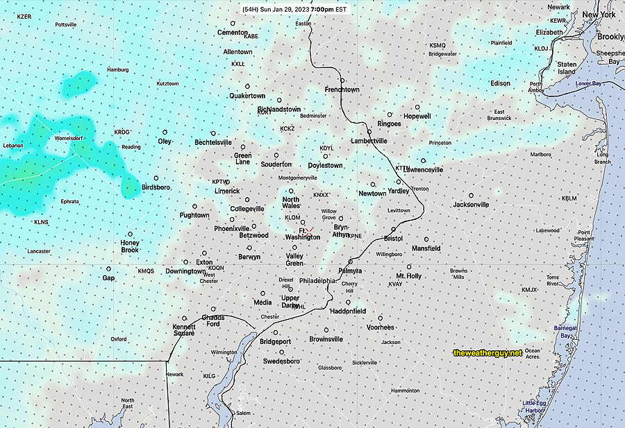
The cold front dissipates as it approaches Philadelphia but very light shower activity makes it through about 3 PM or so. Not all models are on board with these light showers. The ECMWF has been consistent. Cloudy and windy.
NAM-NEST forecast total precip by 7 PM (Click on image for a larger view.)
High temperature 52.2º sd 1.2º ( NBM model – location Lincoln Financial Field, PA)
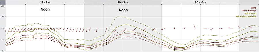
Winds at the Linc
NBM wind meteogram for location Lincoln Financial Field, Philadelphia. (Click on image for a larger view.)
Regarding Potential Snow here in Philadelphia:
Update Sat 1/28 6:26 PM — Cancel these chances of snow; the latest models have trended warmer with precipitation moving mostly to our south.
There’s a chance of an “over-running” event with moisture moving over a stalled frontal boundary late Tuesday night into next Wednesday, Feb 1st.
There’s another chance of a similar event next Sunday night into next Monday, Feb 6th.
Snow lovers- don’t get too excited… we’re talking about 1/2″ or so each ‘event’ with possible changeover to rain or freezing rain. No major storms showing in the models.