Tag Archives: Secondary Low

WOW- YET ANOTHER CHANGE IN THE FORECAST!

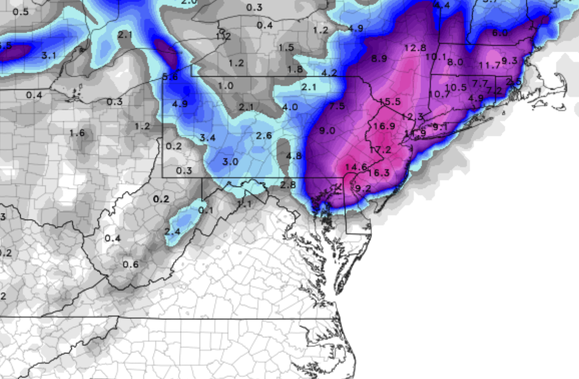
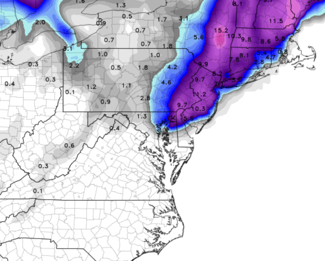
This potential storm for Philadelphia for Tuesday through Wednesday evening has been on the metaphorical radar for almost a week.  The binary nature of the storm and the inherent complexity in modeling such a complex system has pushed the models beyond their limits.

I’ve been ending each of my posts with “expect changes”.  I’ve been doing this for a reason–

There has been tremendous variations in the deterministic model forecast over the past few days.   The main system was expected  on Tuesday, then this system was expected to be suppressed to our south and the Wednesday system further suppressed eastward.

The statistical (Ensemble-based ) models have maintained a strong signal of a storm from Tuesday through Wednesday and have never stopped showing this.

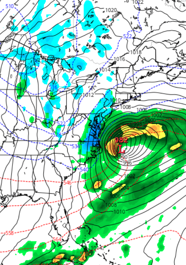
This afternoon’s NAM model has just becoming available.  It shows the Tuesday storm to be relatively minimal, but energy and intensification and phasing of the jet streams now occurs with the second storm on Wednesday. This second system appears to  intensify and hug the coastline!

NAM Forecast for Wednesday morning

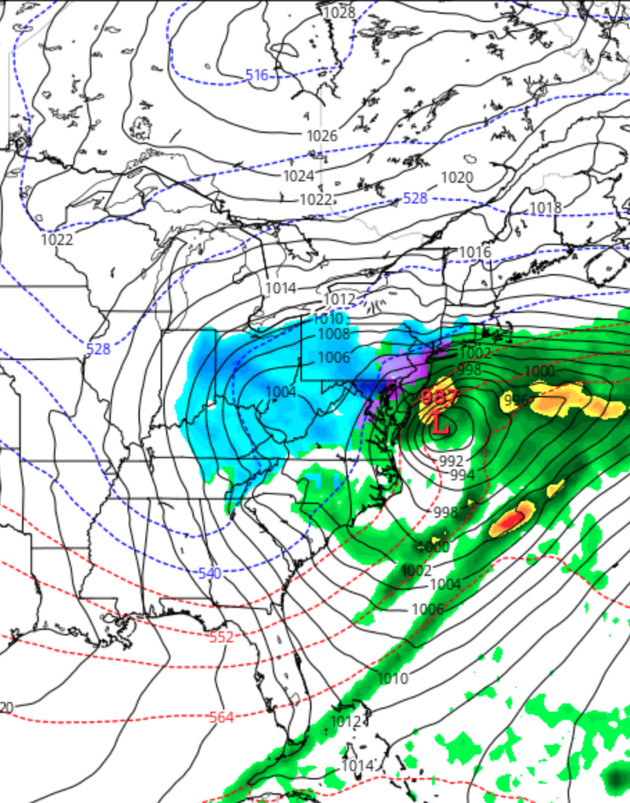
So we’re not out of the woods yet! Indeed, if the NAM is correct, we’ll have a major nor’easter for Wednesday.   Due to Daylight Saving Time, the major models will become available very late.

I’ll be traveling this entire week so updates will not be anywhere as frequent as in past storms!  (I must confess, this past Friday, I moved my airline reservations  to Monday instead of  Wednesday to avoid weather-related travel problems.  This morning, I thought I had made a mistake; but maybe not! ) 

PHILLY MONDAY WEATHER UPDATE

Last night’s GFS model continued with the scenario that a low pressure system was going to develop off the coast, but miss us.  However, the recent trends have been to place this system closer to the coast with greater intensification.

This morning’s NAM has suddenly jumped on this scenario, with low pressure in a similar position, but somewhat more intensified, allowing some snow to move in on the western side and into the PHL area late Monday into Monday evening.

[su_note note_color=”#ebf2d9″]With the system evolving, the timing and QPF values and timing are likely to change.  Current QPF is a very light 0.16 inches water.  Currently not much of a ‘storm’, but driving could be slippery on Tuesday morning rush hour as cold air will be in place.[/su_note]

As mentioned in last night’s post, the GFS has been hinting at something happening off the coast.  This weak signal has been strengthened; some winter precip is looking more likely for late Monday.

NAM prediction for Monday evening
Saturday Morning NAM prediction for Monday evening

Expect details and timing to change.

PHILLY SNOWSTORM FORECAST 9:40 PM EDITION

The tonight’s NAM model data is becoming available.  Here are the trends:

Higher QPF values- precipitation falling as water has increased significantly to 1.80 inches water, in some areas, over 2.0 inches water!

The predicted vertical thermal profile is much COLDER; indeed, critical “thickness levels” and temperatures now support snow into New Jersey where previously it was thought to be mostly rain or rain mix.

With these changes, there’s been a significant increase in predicted snow totals!  Here are the NAM 10:1 snow totals by area:

NAM Final predicted snow totals 10:1 ratio

There are other algorithms that try to take into account other factors such as melting.  One is called the Kuchera Snow Algorithm.

Kuchera algorithm
NAM Kuchera Algorithm Snow Accumulation

I don’t generally find the predefined snow algorithms that useful or accurate.  I believe the 10:1 simple algorithm will do best here and may understate snowfall at times. An average of the two might also prove correct for this storm.

The reason I’m presenting both predefined snow algorithms is to show that significant snowfall is now expected in Philadelphia, NJ as well as in PA.

[su_note note_color=”#ebf2d9″]So we’re looking at 9-17 inches of snow, based on your location, as shown on the above maps.[/su_note]

Timing:  Precipitation as rain is starting as scheduled (9PM) and will mix with and turn to snow by 1-2 AM in western sections and a bit later along the I-95 corridor.   Heaviest snow during the morning and afternoon hours on Wednesday, ending about 7PM or so.

Temperatures are expected to fall to about 32-33 degrees by 2-3 AM with dynamic cooling that will occur with heavier precipitation on Wednesday

Winds will be 15 to 20 mph with gusts near 25 during the day on Wednesday.

The GFS model data becomes available about 10:45 PM.  I expect the GFS QPF values to be less than the NAM values; it always is.  I still think we’re talking about a major snowstorm for Philadelphia and the immediate areas.  This is a high confidence forecast.

I’ll amend this post with the GFS data if it presents a problem with this forecast.

[su_note note_color=”#ebf2d9″]10:45 PM – Tonight’s GFS model data is similar to the NAM. QPF values 1.43  inches water with distribution of precipitation maximum centered around I95, similar to the NAM.  I believe the NAM 10:1 snowfall map above  is a good estimate. [/su_note]