THIS WEEK’S WEATHER

#weather #paweather #wx #pawx #philadelphia

Friday Forecast

Update Fri 03/03 @ 3:32 PM — Like earlier this week, evaporative cooling at the onset of the rain has resulted in a mix of rain and wet snow this afternoon. (Temperatures are in the low 40s) I went back to look at this morning’s models. The GFS and HIRESW-FV3 showed this possibility. The NAM and HRRR did not.


Update Fri 3/03 8:42 AM — The trend continues for a later start of the rain. Now, most likely 3-4 PM, but earlier far southwest of the city. Rainfall during the afternoon hours will be very light, only about 0.03”. Heavier rain starts about 9 -10 PM.


Update Thu 03/02 @ 5:25 PM — The trend for the large rain storm that will affect us Friday has been for the rain to start later in the day. This trend has continued with this afternoon’s models.

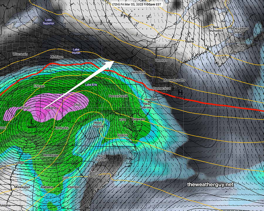
Current forecast: Rain moves in between 1 and 3 PM, earlier in the far southwestern suburbs of Philadelphia. It will become quite WINDY, especially towards midnight Friday.

By Saturday morning, about 0.75″ to 1.3″ of rain is expected in our immediate area—

Today’s NAM-NEST Total rainfall by 11 AM Saturday. Model precipitation forecasts should never be taken literally regarding placement of the heaviest rain bands. (Click on image for a larger view.)

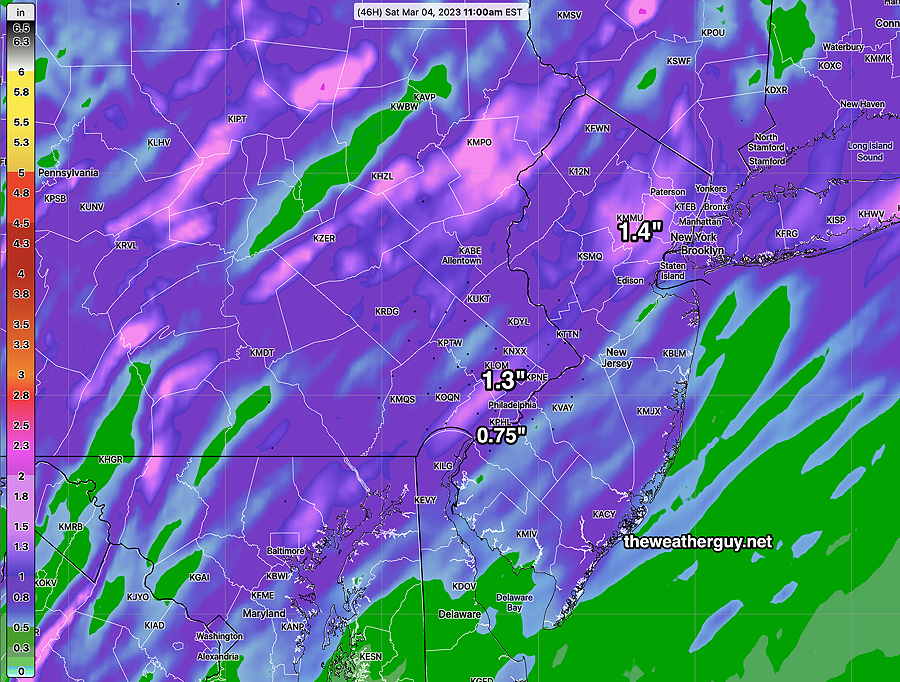
Skies remain cloudy and unsettled on Saturday with lingering rain sprinkles and snow showers far north. It will be windy.


Thursday Update

Update Thu 03/02 @ 8:57 AM — As we saw yesterday, cloud cover is one of the toughest weather parameters to forecast correctly. Today may be no exception.

Most models have clouds lifting to significant high-level cloudiness with sun filtering through by noon Thursday. But the GFS has some stubborn mid-level cloudiness lingering into mid afternoon.

As for the rain on Friday, the trend has been for a later onset, probably closer to 1-2 PM. The rain moves in from the south. The rainfall later Friday and Friday night will be heavy at times. About 1-1.5″ of rain expected.

As mentioned in last night’s update, Saturday looks to be very cloudy with light widely scattered sprinkles and even some snow flurries (northern sections) possible.


Update Wed 03/01 @ 8:09 PM — A fast moving system will bring light showers just before daybreak Thursday. Showers move off to the east by 8 AM and clouds break for sunshine through a high cloud layer by about 11 AM from west to east.

The larger storm to affect our weather on Friday looks like it will move in later in the morning. around noontime. The chances of any sleet or frozen precipitation at the start looks to be low. A rain event for our immediate area.

Rain Friday afternoon and night.

Saturday looks very cloudy with low pressure lingering. Even a chance of widely scattered snow flurries or sprinkles.

Wed 8:16 PM Forecast Review — We had significantly more cloudiness today than forecast.

Wednesday Through Friday

Previously Posted Tue 8:15 PM —

Low pressure system that lingered (as forecast) today will move off to the east. Wednesday will be mostly sunny. Highs 52º-53º. Winds increase somewhat in the afternoon.

GEFS forecast for Wednesday at 1 PM Low pressure (1) links up with a stronger low in the Great Lakes to develop into a coastal low (2) near New England on Thursday. (Click on image for a larger view.)

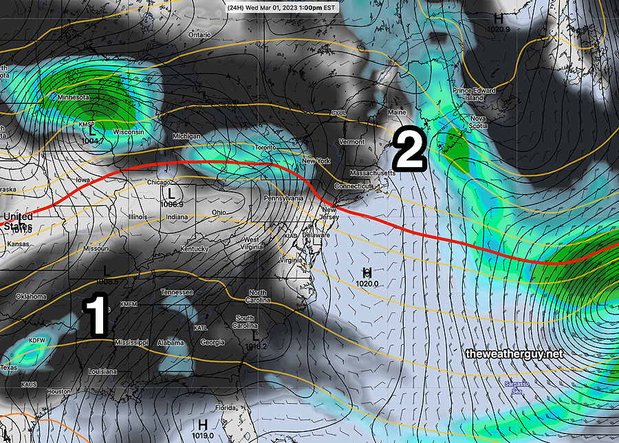
For Thursday, low pressure approaches from the west, but the models have it transferring its energy to a secondary low off the New England coast.

We start out cloudy on Thursday with some showers mostly western suburbs. Then partly cloudy/partly sunny. Mild. High near 60º.

On Friday, a strong storm (similar to Monday night’s storm) approaches and takes a western track. We’ll be in the warm sector, but precip may start out as sleet/snow mix in the early morning. Rain for much of the day.

GEFS forecast for Friday 1 PM. (Click on image for a larger view.)


THIS WEEK’S WEATHER

#weather #paweather #wx #pawx #philadelphia

Tuesday Forecast

Update Mon 02/27 @ 8:15 PM — The heavier rain will be ending before daybreak. Tuesday morning will have very low clouds, areas of fog and some widely scattered sprinkles as a weak trough remains over central PA and Maryland.

The low clouds gradually lift during the afternoon, but it may be mid (to late) afternoon before things break up for some sun.


Mon 8:15PM Forecast Review — It’s interesting that the weather outside is unfolding closer to yesterday’s models than this morning’s models.

Examples : The rain started around 4-5 PM as forecast yesterday but today’s models had forecast a later start time.

Example: The transition to sleet and snow is further south, almost as predicted by yesterday’s models, but today’s models had all rain in the city and just outside.

If we backtrack to yesterday’s forecast, it will changeover to rain by later this evening.

Updated Monday Forecast

Update Mon 02/27 @ 9:11 AM — Current models have decreased the extent and duration of the sleet this evening.

Clouds increase by 1 PM and lower and thicken during the afternoon.

Rain starts between 6 and 7 PM in the city, but areas near Yardley/Trenton, it may start as light snow.

It’s looking like it stays rain in the city and immediate suburbs, but northwest, it transitions to a mix of sleet and rain around 9 PM. Here’s where the mix occurs according the the HRDPS

Canadian HRDPS precip TYPE forecast for 9 PM tonight. Much less sleet than forecast last night. Click on image for a larger view.)

It then moves back to all rain except areas near Quakertown and Allentown and north where a mix lingers longer before changing to all rain after midnight. Temps remain above freezing here.

Update Mon 02/27 @ 10:20 AM It looks like much of Tuesday through early afternoon will be very cloudy with sprinkles in the morning.


Previously Posted Sun 9:10 PM —

Monday Evening Sleet Rain mix

The rapidly changing weather pattern will produce yet another change Monday evening.

Low pressure will bring clouds Monday afternoon, then precipitation Monday late afternoon, starting as early as 4 PM but possibly as late as 6 PM.

Due to the initial rain falling through very dry air, the onset of the rain is expected to result in evaporative cooling.

This evaporation cooling will drop the air temperature to the “wet bulb temperature”, which will be below freezing in such a dry column of air.

So precipitation may start as rain, but this dynamic evaporative cooling process will cause the precipitation to change to sleet as the rain falls and freezes falling through this colder lower layer of air.

Tonight’s 00z NBM model Precipitation type at 9 PM (Click on image for a larger view.)

By 11 PM to midnight, Philadelphia and the immediate surrounding areas should change back to all rain.

Here’s the NBM by 3 AM —

NBM forecast for 3 AM. Tuesday. Only areas north of Allentown will have snow, but that will also mix with rain alter. (Click on image for a larger view.)

Some accumulation of sleet possible in the immediate PHL area during the evening but it should all melt with the considerable additional rain expected, so no accumulation around here by morning.

These dynamic temperature situations sometimes causes surprises, but there appears to be good model agreement with the current forecast.