Tag Archives: Philadelphia area Weather Forecast

WEEKEND WEATHER FORECAST

Not so sure we’re going to hit 70 ° on Sunday.


Fri 10 PM Update – No significant changes. I want to emphasize the winds both Saturday and Sunday will be 15-20 mph with gusts.


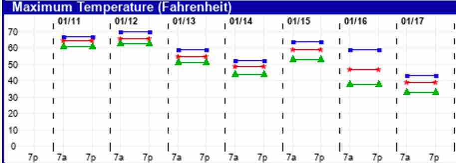
The very warm temperatures predicted for this weekend have been well-advertised.   The current EKDMOS  (Ensemble Kernel Density Model Output Statistics) shows very warm temperatures: 67º for Saturday and 68º for Sunday (Blue Bell)—

O EKDMOS High Temp Forecast for Blue Bell, PA

A strong southwesterly flow of warm air ahead of an approaching cold front will bring the unseasonably mild air.   But it won’t be a blue-sky day.  With the warmth will be considerable cloudiness and some uncertainty about the amount and timing of sunshine (if any).  It will be somewhat windy.

For Saturday, depending upon the model, we have sunny skies in the morning, becoming cloudy (NAM)

or clouds early breaking for sunny skies by noon (HIRESW-ARW) then cloudy later,

or mostly cloudy all day (GFS)!

For good measure, the NAM-NEST has some widely scattered showers in the morning (not supported by the other models).

So the warmth is a certainty, the cloud cover less so.   I’m leaning toward the HIRES-ARW with clouds breaking for some sun mid-day, then clouds return.—

HIRESW-ARW-MEM2 Cloud cover forecast 1 PM Saturday.  After 1 PM, clouds start move back in. Click for larger image.

The cold front moves through Saturday night.  There may be a spotty shower early evening, then heavier rain after midnight.

For Sunday, all models have the front moving through about 7 AM with clearing afterwards.   Mostly sunny skies but windy.  High temps near 70, but that will be late morning.   Temperatures slowly fall during the afternoon.

I don’t expect any changes, but I’ll do an update later if there are,  based on the new model runs.

TUESDAY COASTAL LOW FORECAST

[su_note note_color=”#defcdc”]Mon 6 PM Update: Today’s model runs continue with the forecast that the low pressure system’s precipitation shield will stay mostly east of Philadelphia. Little if any precip expected west of the Delaware river.

Mon 7:12 PM Update:  I just checked the latest GFS model run from 1 PM.  It has expanded the precipitation into the Philadelphia area and is showing 1.3 inches of snow by 8 PM.  None of the higher resolution models support this. I will update later this evening with this evening’s model runs.  The new GFS  will be available about 10:45 PM.  

[/su_note]

…from this morning—

There has been a consistent forecast for a low pressure system to move to and develop along the coastline near NJ with the current time frame being Tuesday afternoon and evening.  The track and amounts of snow/rain have clarified in the past day.

The (new) GFS has been the most consistent with this forecast track and intensity— the low develops late in the process and moves mostly eastward rather than up the coastline.

Last night’s 1AM (06 UTC)  run of the GFS captures the event with accumulating precipitation barely making it into Philadelphia —

GFS Precipitation forecast 4:30 PM Tuesday

The other models, (NAM, CMC GDPS, ECMWF, etc) have joined in with the GFS forecast track and show similar precipitation coverage and amounts.

Some wet snow showers or flurries possible in Philadelphia and just north and west. Some of the models forecast a light coating of snow (< 0.5 inches) in central and eastern NJ.