WEEKEND WEATHER FORECAST

Clearing New Year’s Day

Update Sat 12/31 @ 4:36 PM — Happy New Year, everyone!

The steadier rain has begun to move in on schedule. (I wish I had included the fog in today’s forecast today; it was in my earlier “weekend outlook”, but only morning fog. The very light drizzle should have been apparent from the models, but it was overlooked. )

The rain tapers off about 1 AM.

Sunday

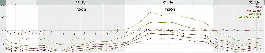
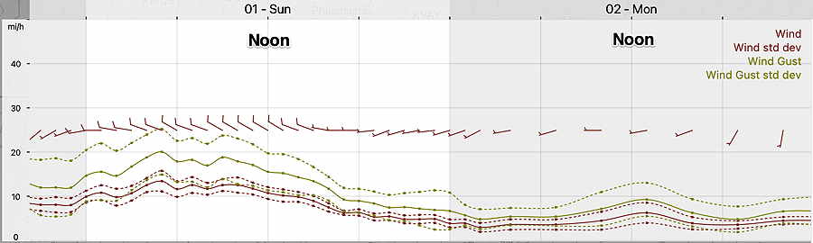
Clearing early Sunday morning becoming mostly sunny. Winds are less than previously forecast, gusts to about 20 mph but decreasing during the afternoon.

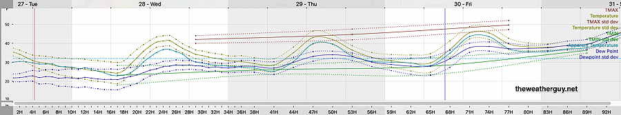
High temperature 52.3º sd 2.8º NBM model – for location Blue Bell, PA

Saturday’s 19z NBM Wind meteogram forecast for Sunday, location Blue Bell, PA (Click on image for a larger view.)

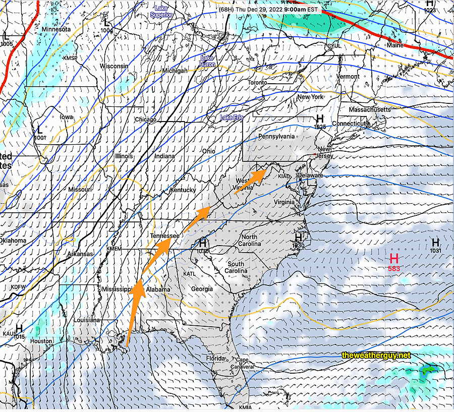
I’m keeping my eye on a potential coastal storm early Friday morning. We may get some light snow on grassy surfaces. There simply isn’t enough cold air in Canada now to give us a snow storm. The mother-lode of cold air descended last weekend and it hasn’t been replaced yet.


A Change in the forecast

Update Fri 12/30 7:16 PM — Based on the NBM and Canadian HRDPS, I’ve updated the rainfall for New Year’s Eve to 0.40 inches.

Fri 12/30 @ 5:50 PM — There’s a change in the forecast that has followed a trend that started with yesterday’s models.

Saturday

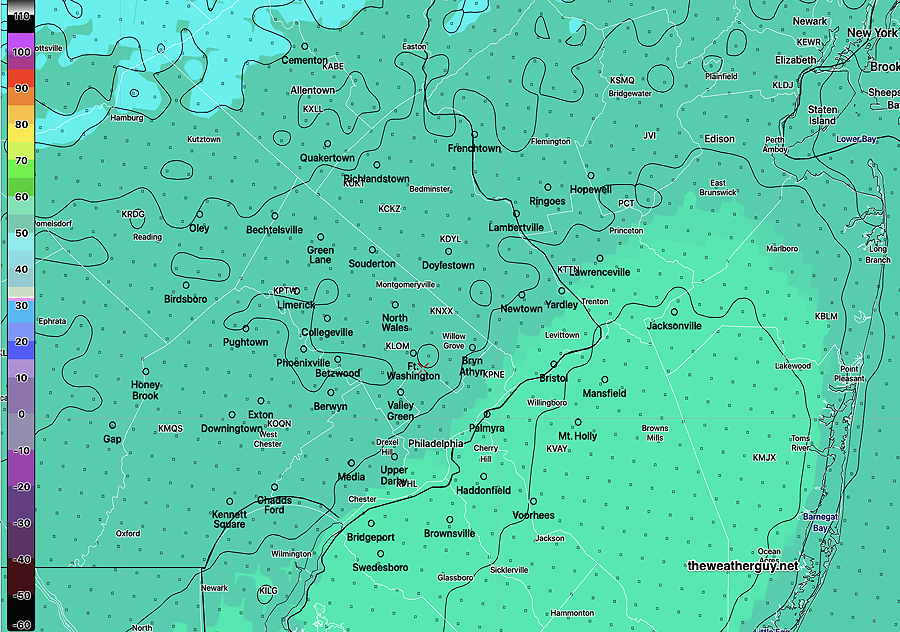
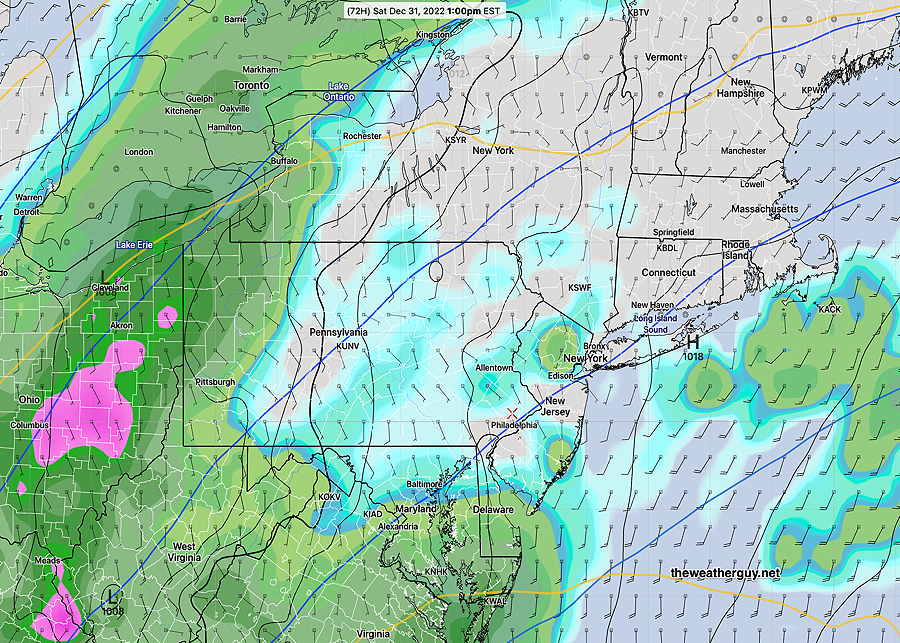
Saturday: The main swath of rain on Saturday will be east of us, into NJ and off the coast.

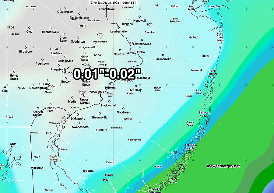
This afternoon’s 18z GFS captures the trend with only light rain (0.01-0.02″) in the immediate Philadelphia area before 4 PM—

Friday’s 18z GFS shows only very light rain accumulated by 4 PM Saturday in the immediate PHL area. Heavier rain along the coat. (Click on image for a larger view.)

Steadier light rain moves in during Saturday evening but the total rainfall will be light to moderate ( 0.40″) New Year’s Eve. The light rain starts tapering off about 1 AM Sunday. Mean high temperatures (NBM) have trended cooler with the same high spread of uncertainty.

High temperature 51.7º sd 3.3º NBM model – for location Blue Bell, PA

Sunday

Sunday will be mostly sunny, with a few short periods of cloudiness from upper air disturbances. It will be windy and gusty at times, especially during the morning hours.

High temperature 52.7º sd 3.4º NBM model – for location Blue Bell, PA

FRIDAY AND WEEKEND OUTLOOK

Update Fri 12/30 @ 9:36 AM — A quick update to the weekend outlook posted last night (below), based on the latest models.

Saturday will be quite cloudy. Some fog possible in the morning with low clouds throughout the day.

Some light showers are possible late morning and around noon especially just over the river in NJ. The bulk of the rain will be moving in between 2 and 5 PM around the city. Rain tapers off after midnight. Bulk of the rain is moving to our southeast and total rainfall will be less than 0.4 inches in or area.

NBM is showing a slight decrease in mean high temperature on Saturday to about 53º but it has increased its spread to 3.5º (So think of it as 53º ± 3.5º, a wider than usual range of uncertainty.)

For Sunday, New Year’s Day, skies clear during the morning hours. Winds and wind gusts still robust, but maxing out about 27-30 mph instead of the 35 mph gusts posted yesterday. NBM mean high temperature of 53º again with an even larger range of uncertainty, ± 4.0º.

I’ll update the forecast later today.


Previously Posted Thu 7:49 PM —

If you’re planning on outdoor activities, Friday will likely be the best day weather-wise of the coming three.

Friday

Sunshine with milder temperatures for Friday, with a high of 54º-55º. Thickening high level cirrus clouds expected mid to late afternoon.

NBM model forecast high temperatures for Friday. Black contours are 2º increments (Click on image for a larger view.)

Saturday and Sunday Outlook

Saturday will be cloudy. Scattered light sprinkles as early as noontime, but steadier rain moves in between 2 and 4 PM. It will be mild. Latest models have backed off on forecasting the heavy rain; light to moderate rain expected around midnight.

Sunday will continue mild and the sun should break out as skies clear. A big consideration will be the wind, with wind gusts around 30-35 mph, tapering later in the afternoon.

Thursday’s 19z NBM model wind meteogram for Blue Bell PA (Click on image for a larger view.)