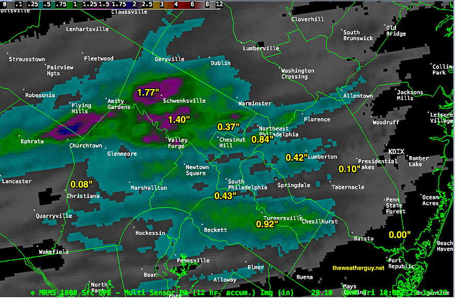
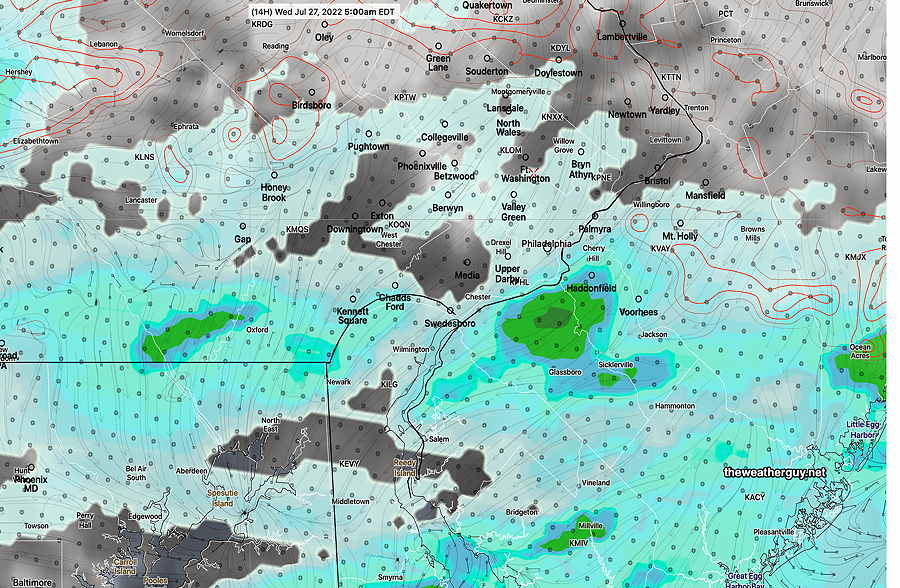
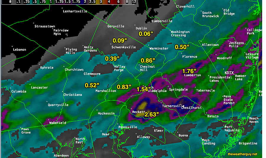
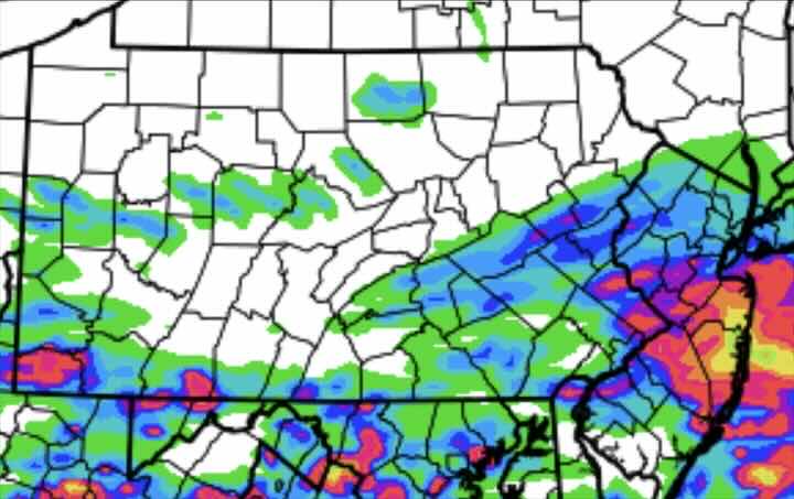
Update Thu 08/11 @ 9:24 AM — Areas, especially in NJ, had some decent amounts of rain Wednesday night—
MRMS accumulated rain Wednesday night into Thursday morning. Many areas in NJ had over one inch. (Click on image for a larger view.)
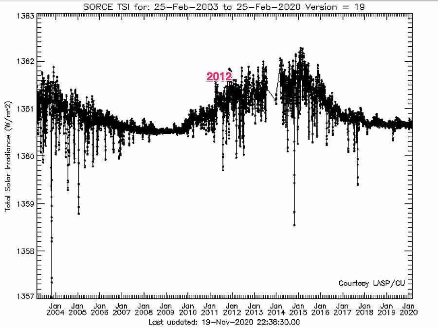
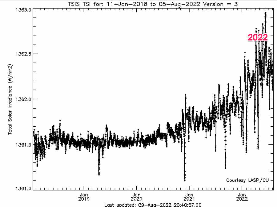
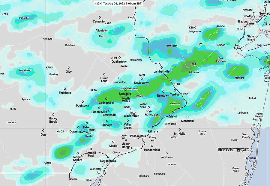
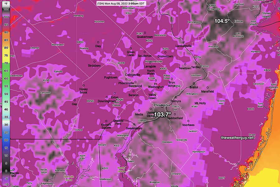
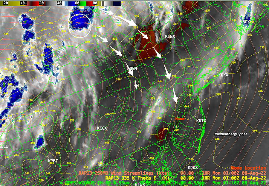
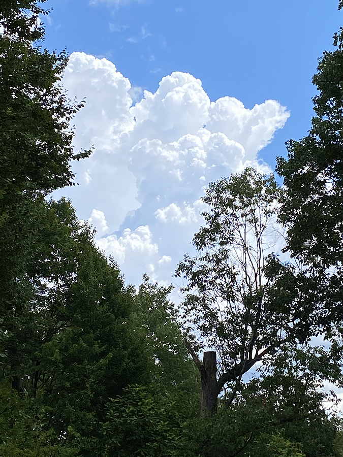
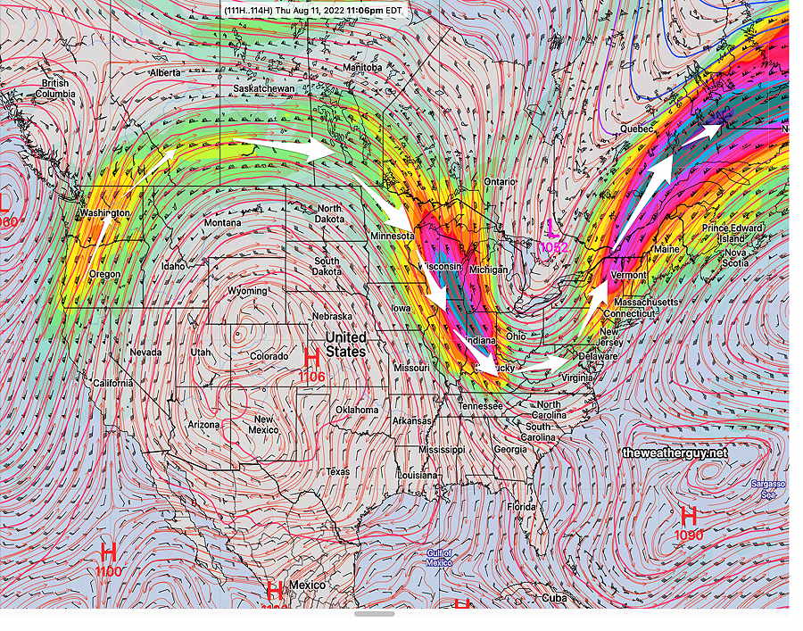
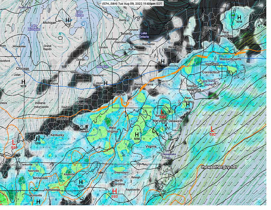
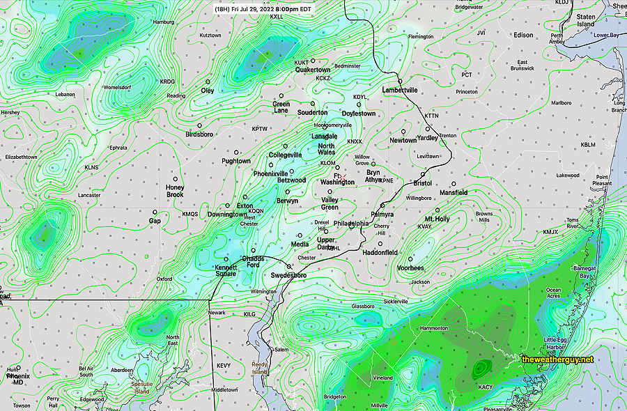
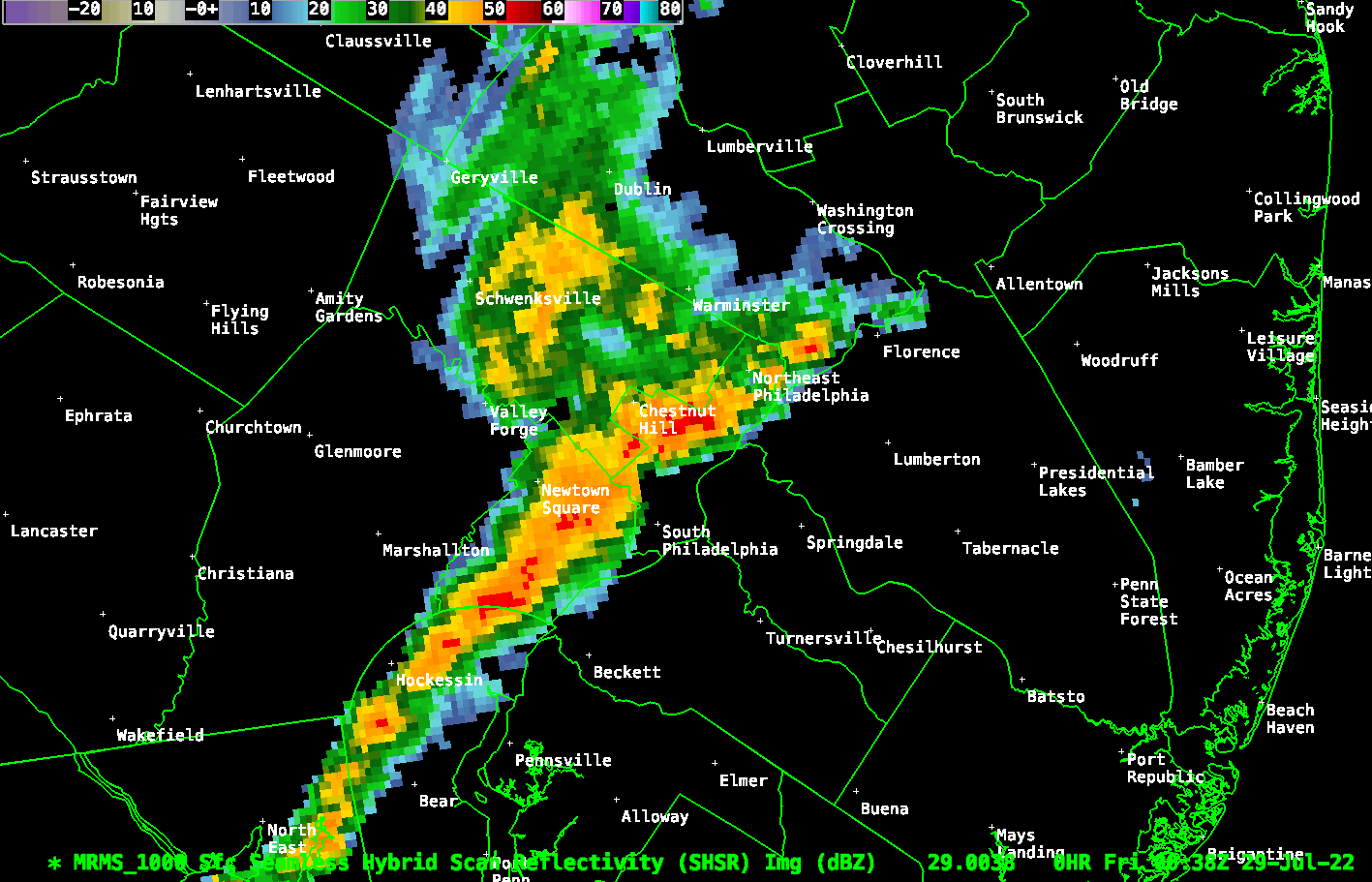
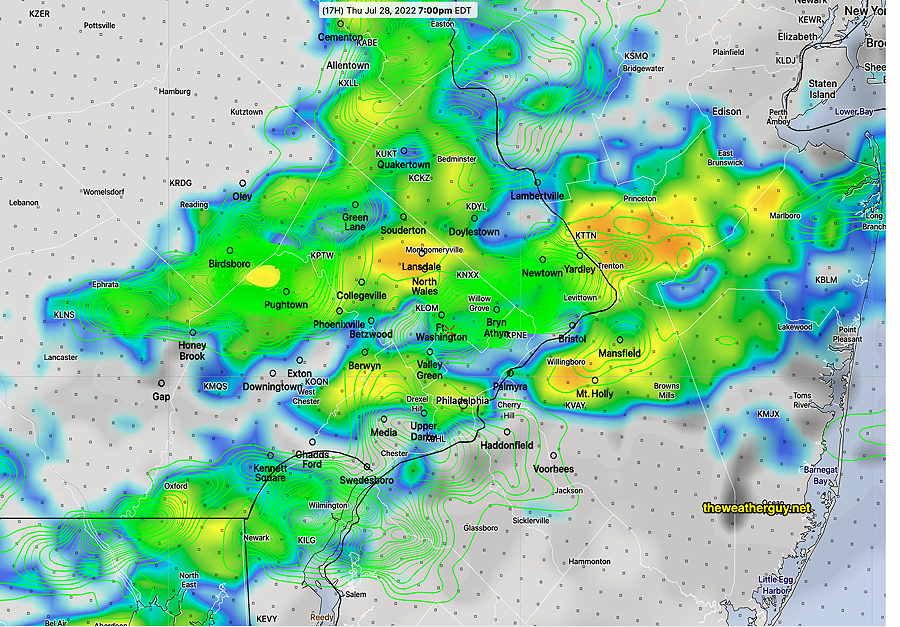
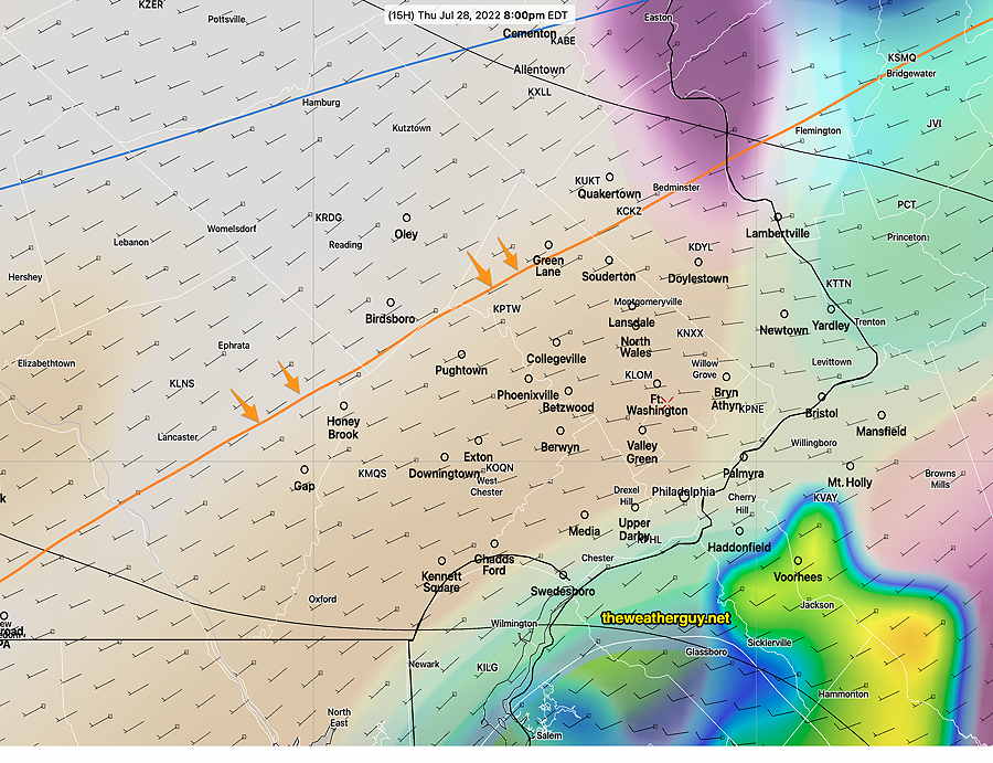
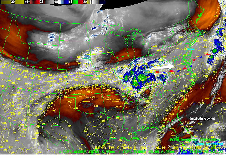
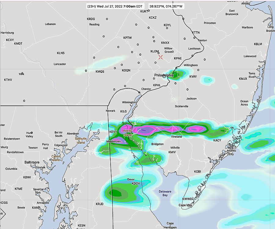
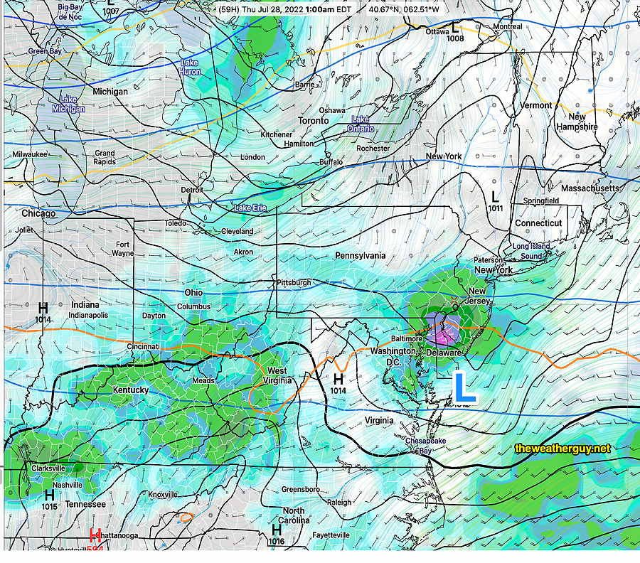
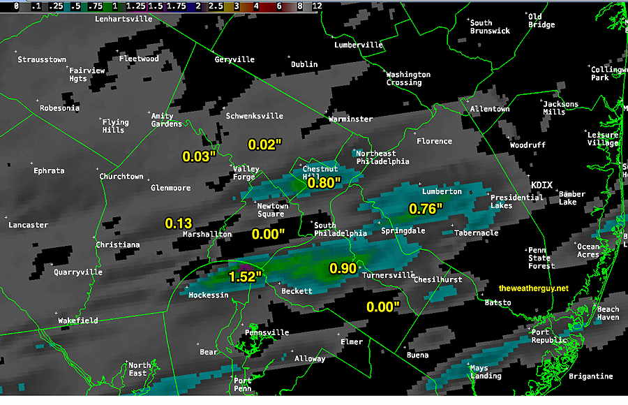
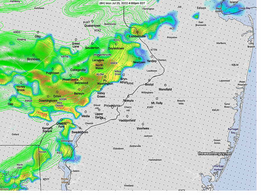
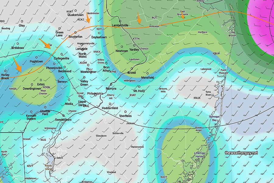
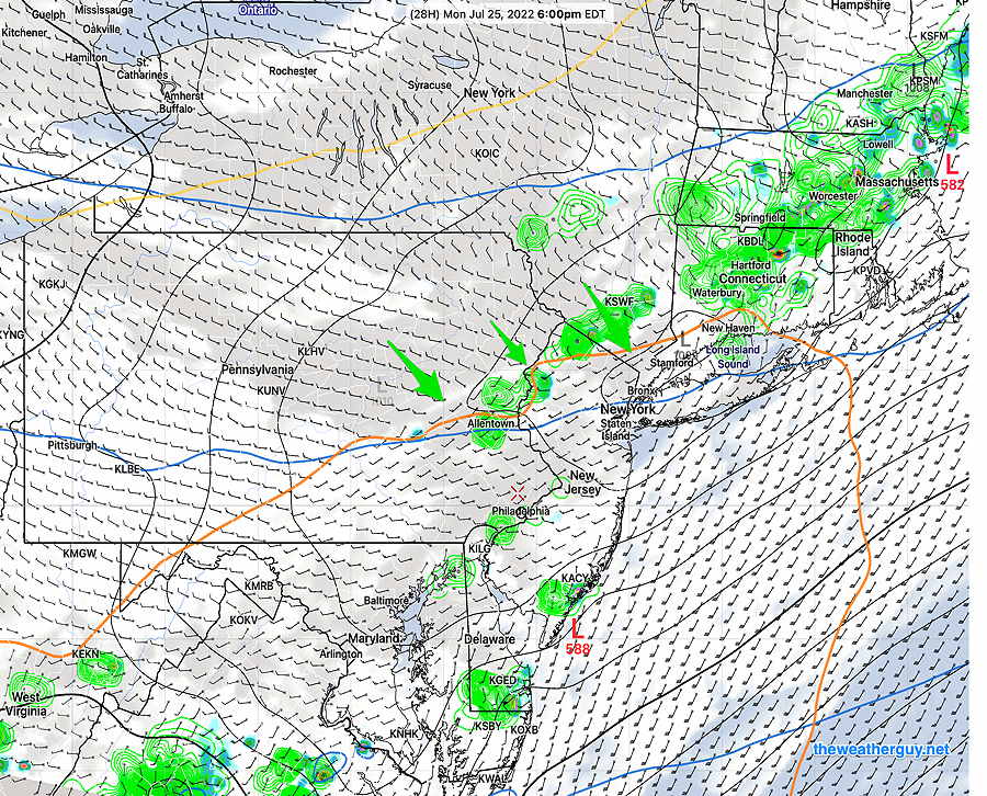
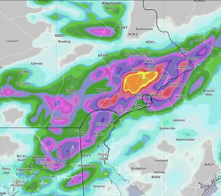
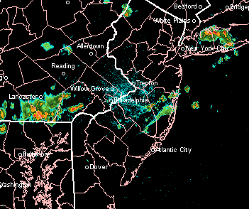
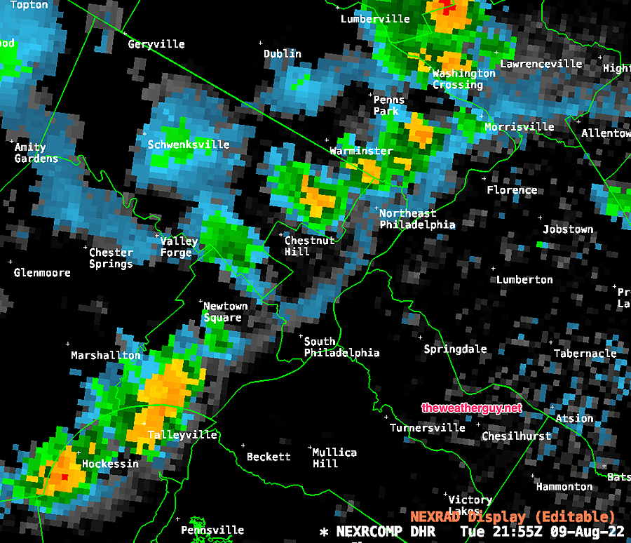
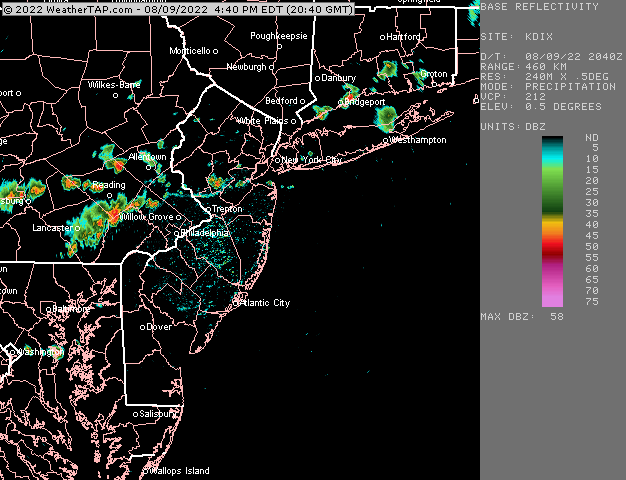
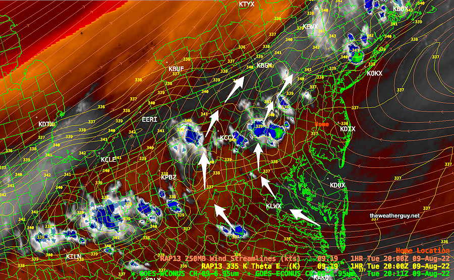
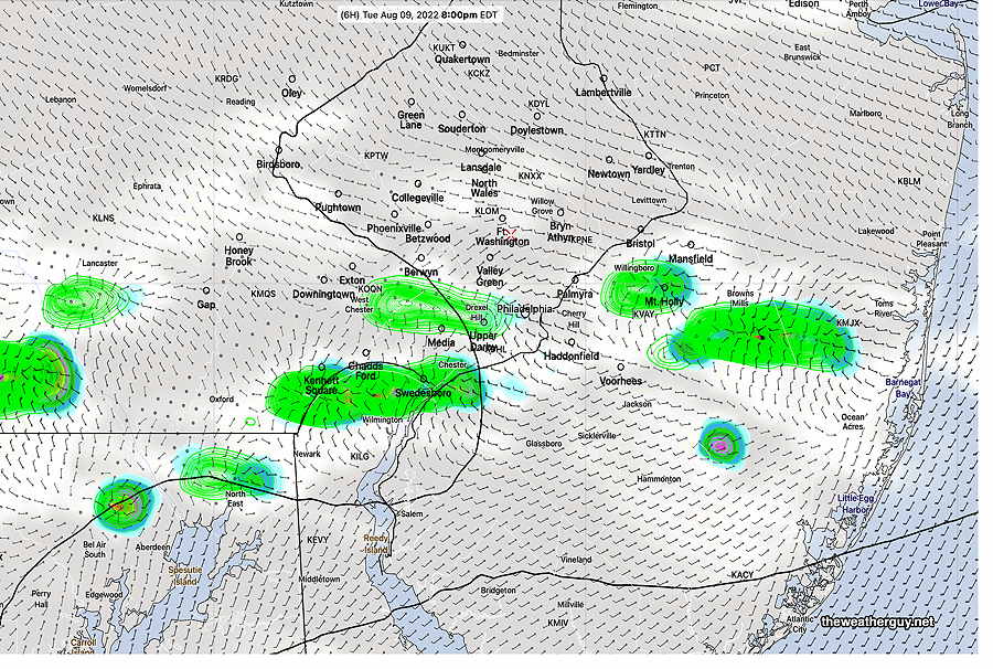
Compare the above actual rain amounts above to the forecast of the experimental LAMDAX model shown here. Not perfect, but not bad!! Better placement than the NAM-NEST.
The experimental LAMDAX isn’t available every day, and when available, only web type low resolution graphics are released; no raw data is available outside of NOAA.
Rain Wednesday night into Thursday morning
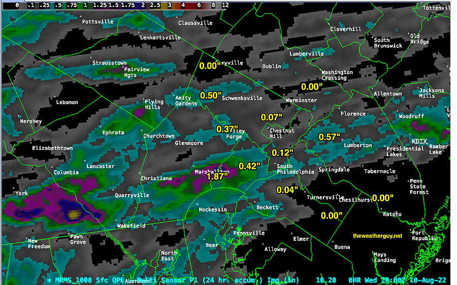
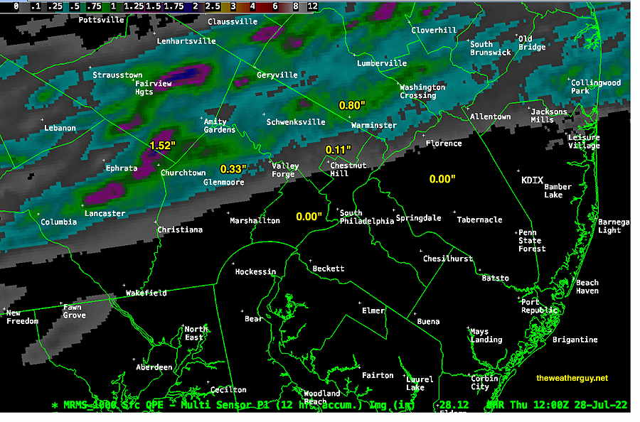
Updated Wed 8/10 10:33 PM — Tonight’s models are showing considerably more rain tonight than previously forecast, in line with the experimental LAMDAX model. Many areas, but not all, may receive 0.4 to 0.8 inches. Every model shows a bullseye of localized heavy rain, but the location varies by model. Here’s the latest NAM-NEST, which is most extreme with its bullseye —
NAM-NEST. The bullseye of heavy rain is 4 inches, probably a modeling error.
Updated Wed 8/10 9:08 PM — Updated with the latest LAMDAX precip forecast which just became available below.
Updated Wed 8/10 5:54 PM —Last night, while a very few areas received a substantial rainfall, most areas last night only received a paltry amount. Even the area around Citizens Bank Park only received about 0.30″ yet it caused two rain delays.
Rainfall totals for last night (Tuesday evening/night), according to the MRMS—
MRMS total 24 hour rainfall (Tuesday evening/ night) (Click on image for a larger view.)
As for this evening (Wed), there’s lack of model agreement about where a low pressure system will develop along the stalled frontal boundary that moved through yesterday. This translates into a wide range or forecasts, most with rain south of the immediate PHL area.
NBM total rainfall forecast Wednesday night into early Thursday morning. Most of the rain falls from Philadelphia and southward. (Click on image for a larger view.)
We already know this forecast will be off….the same models forecast rain already beginning in some areas right now, but nothing to be seen on radar and I see blue skies outside my window.
Most of the rain will be gone by 8 AM, but a few areas may have some lingering showers, all gone by 10-11 AM, except in eastern NJ. Not a drought-buster.
Just for the heck of it, here’s the latest experimental LAMDAX high resolution model forecast, showing a very different location of the heaviest precipitation . (The LAMDX looks like it’s being developed and groomed for the next generation of models, likely to be ready for operational release in 2024. It’s still experimental and not finalized.) —
Today’s experimental 12z LAMDAX showing much different location of heaviest precip axis. The LAMDX has limited availability with only pre-made graphics, no raw data available. Click on image for larger view.
Updated Tue 8/09 8:37 PM — We did’t get a drop of rain. Maybe this time —
Radar at 8:39 PM
Update Tue 08/09 @ 6:03 PM — I think we have the answer: the storms fell apart as they approached. My neck of the woods didn’t get a drop. I don’t need to change the headline title of this post which I have kept since Monday evening.
Update Tue 08/09 @ 4:24 PM — Some storms have broken out to our west. The question (that will be answered soon): will they fall apart and diminish as they approach Philadelphia and New Jersey?
Courtesy of weathertap.com (Click on image for a larger view.)
Water Vapor Image at 4 PM shows considerable dry and a very warm air mass (orange coloration) Some popup storms, aided by mountain orographic lift, near the Poconos. But the overall jet level flow is anticyclonic (clockwise) as shown by the white arrows, greatly reducing the chance of showers developing here. (Click on image for a larger view.)
This afternoon’s 18zHRRR shows minimal showers moving through between 7 and 9 PM—
18z HRRR shows minimal, spotty showers moving through between 7 and 9 PM. (Click on image for a larger view.)
A Drought?
New Jersey has just issued a “drought watch”. We’re ‘watching’ here in Pennsylvania too!
There’s talk about this is the first drought here in about 10 years. Any coincidence that we’re in a similar phase (increase) in the ~11 year sunspot cycle? I don’t think so.
I have no idea about the precise mechanism causing drought conditions. BUT each solar maxima increases total solar irradiance reaching our planet by over 1 Watt/M2, which clearly must raise the temperature of the atmosphere. I’m conjecturing that an increase in upper atmosphere temperatures causes drought conditions. Superimpose that increase in temperature with climate change and the effect could be significant.
The study of sunspot cycle and Total Solar Irradiance is performed by the TSIS satellite and previously by the SORCE satellite, operated by the Laboratory for Atmospheric and Space Physics.
Here are summary plots showing the increase in irradiance for the past and current sunspot cycles—
SORCE data (Click on image for a larger view.)TSIS data (Click on image for a larger view.)
I went back through my old posts from 2012. I’ve been linking the sunspot cycle with dry conditions for 20 years.
Updated Mon 8/08 10:55 PM — Tonight’s high resolution models are showing the possibility of tomorrow’s showers being an even greater disappointment. Many areas may receive little or no rain.
Update Mon 08/08 @ 8:03 PM — Our severe heat wave will end tomorrow evening as a cold front moves slowly through. Despite high CAPE values and high precipitable water values, the models are cranking out only scattered showers and thunderstorms.
Total rainfall for most areas will be in the paltry 0.2-0.4″ range. Some areas will have less and a few up to 0.75″ in our area. I offered an explanation for the lack of rainfall earlier in this post.
NBM forecast rainfall—
NBM 1 hour accumulated rainfall at 9 PM. This 1 hour snapshot of the rainfall gives a sense of the amounts and coverage. (Click on image for a larger view.)
There’s a range for the onset of the showers: as early as 4-5 PM, but with most of the activity between 7 PM and 11 PM.
We may receive some additional rainfall Wednesday evening with a secondary cold front.
Update Mon 08/08 @ 8:36 AM — Monday’s weather will be notable for the much higher dew points (70º-75ª) than the high temperatures (92-94º).
The max heat index (maximum “apparent temperature”) according to the NBM at 3 PM —
06z NBM apparent temperature (heat index) at 3 PM Monday. (Click on image for a larger view.)
Most models keep any pop-up thunderstorms to our far northwest today. But with the increase in humidity, a pop-up thunderstorm in our area can’t be ruled out. There is a large upper air disturbance that will rotate through our area, visible on water vapor imagery —
WV image for 8:16 AM showing disturbance near Great Lakes. The greatest chance of any popup storms is just our northwest (see yellow isentropic contours). The strong anticyclonic curvature of the upper winds will work against any storm formation.
Yesterday, storms tried to develop but failed—
Cumulus with strong vertical growth on Sunday about 12:30 PM. (Click on image for a larger view.)
Originally Posted Sun 8:19 PM —
The current heat wave continues through Tuesday afternoon. Little relief from dry conditions.
A change is on the way Thursday —A significant dip in the jet stream on Thursday will result from high pressure building in to the eastern third of the country—
GEFS jet stream winds (250 mb) Thursday evening showing significant trough over the eastern third of the US. (Click on image for a larger view.)
Before we get to Thursday, we have to deal with a complex situation late Tuesday and Wednesday.
Between Tuesday evening and Thursday a cold front will struggle to move through.
Ordinarily, we’d expect heavy thunderstorms and heavy rain (much needed!) with a cold front moving into very warm humid air. And I wish I could be confident that the immediate Philadelphia area will receive that heavy rain we need.
But the GFS shows a complex frontal passage with the upper air ridge hanging tight on Tuesday night with the front stalling—
GFS forecast for Tuesday evening 11 PM. Shows showers/thundershowers but the immediate PHL area not receiving all that much as the upper air ridge (orange 576 thickness line) still hangs back over central PA. The slowing front will have several areas of low pressure develop along it. (Click on image for a larger view.)
The front makes another move through Wednesday night with more showers and thunderstorms Wednesday afternoon and evening.
Zooming in on 8 PM Wednesday night, that pesky 576 thickness line hangs back after the front moves through and and the immediate PHL area appears to get short-changed in the rain department.
GFS Forecast for Wednesday 8 PM shows the immediate PHL area receives a paltry amount of rain with the front! The 576 thickness line hangs back. (Click on image for a larger view.)
Next Thursday through Sunday look great. But if you’re hoping for relief from lawn watering, I’m afraid it may not happen. Should surface low pressure develop in a slightly different position, things might change.
Update Fri 07/29 @ 7:44 AM — Last night, our area received varying amounts of much-needed rain. Here’s the amounts we received Thursday evening according to the MRMS—
MRMS accumulated 12 hour precipitation (Click on image for a larger view.)
For this evening (Fri), the models are less enthusiastic about additional rain. The HRRR has much of the area with just spotty amounts, many areas with no rain. The HREF forecasts some rain, but scattered with light amounts. Not a drought-buster this evening.
The HREF has any showers/thunderstorms beginning this evening around 5-6 PM (a few isolated showers before then) and continuing through 11 PM or so.
HREF shows light, scattered showers—
HREF 1 hour precipitation at 8 PM this evening. Exact placement should not be taken literally with weather models. This is a 1 hour snapshot. Additional rain through 11 PM. (Click on image for a larger view.)
My Weekend Weather Forecast will be posted this evening.
Thu @ 8:50 PM —Forecast Review— The storms tonight came in fairly close to the time forecast of 6-9 PM. (This morning’s forecast had been based on the HREF and the 06z HRRR.)
Much more [needed] rain than had been forecast and some of the storms are blossoming in Philadelphia. The activity is still expected to dye off as it moves into NJ as vertical shear values drop off significantly.
MRMS live capture at 8:40 PM (Click on image for a larger view.)
Update Thu @ 9:14 AM — We did have some showers shear off to the northwest last night, as some models had forecast—
MRMS Precip totals show about the showers just brushed the northwest corner of Philadelphia early this morning. Far northwest areas enjoyed some much needed rainfall (Click on image for a larger view.)
The models are advertising another round of showers and storms Thursday evening (tonight) about 6 PM- 9 PM. These showers are more likely to make it through more of Philadelphia before they diminish over NJ.
Latest HREF forecast for 7 PM this evening—
HREF simulated Radar and accumulated rain (contours) forecast for 7 PM this evening. (Click on image for a larger view.)
I am a bit more confident that some accumulating rain will make it into Philadelphia and immediate areas, although amounts may be small, variable and very non-uniform.
Why am I more confident? First, several models have this forecast, including the model blend (NBM). A new model under development (FV3 LAMDAX) correctly predicted last night’s showers and it is predicting the showers making it into Philadelphia. Predicted vertical shear values are somewhat higher tonight in our immediate area as well.
Finally, the 576 thickness line is flat and is no longer anticyclonically curved in our area as has been the case for several weeks now —
RAP forecast 576 thickness line shows flat contour instead of the anticyclonic curvature of the past several weeks.
Working against the chance of rain is the continued low soil moisture and the relatively weak vertical forcing of the trigger for tonight.
Update Wed @ 8:13 PM — Not much happening. The dry spell continues and the models are over-forecasting rain in western PA as I write this.
Several models have some showers developing in our area around and after midnight. Current water vapor imagery shows weak disturbances to our west—
Water Vapor Satellite image shows some weak disturbances in western PA expected by some models to move in between midnight and 5 AM with light showers. (Click on image for a larger view.)
While some models have showers for us between midnight and 5 AM, the HRRR has them falling apart as they approach Philadelphia. I wish I could be confident in forecasting another 0.10 inches of rain tonight, but I’m not.
The dry spell (perhaps “mini drought”) has played havoc with the model forecasts over past weeks. Rainfall has been consistently over-forecast by the models.
There’s a front moving through Friday afternoon to clear out the weekend. The latest GFS has little to no rain for the Philadelphia area, while forecasting some for western areas and parts of NJ.
Updated Tue 9:46 PM — Tonight’s models keep any light showers well to our south. The dryness continues.
Revised Update Tue @ 8:29 PM — A weak wave in West Virginia along the stalled front will give us a chance of very light scattered showers towards daybreak Wednesday especially south of the city—
WV image with GFS contours Tuesday evening (8 PM) shows weak wave that may give us light showers towards daybreak. The model seems a bit fast compared to the water vapor, so any light precip may linger into Wednesday morning. (Click on image for a larger view.)NBM accumulated rain forecast for 5 AM Wednesday. The NBM may be overdoing the precip.
Very light precip (0.10 inches or less) is expected with this disturbance. Again, most of the rain will be south of us. Another may affect us early Thursday morning.
Update Tue @ 9:30 AM —There’s a stalled (stationary) front to our south. Low pressure waves will develop in the Midwest will move along it to our south. Precipitation from one wave will mostly pass to our south early Wednesday morning—
Current Water Vapor Image from 9:16 AM with superimposed RAP model contours. Low pressure along the stationary front will move eastward late tonight, mostly missing our area. (Click on image for a larger view.)Latest 12z HRRR forecast for rain early Wednesday morning. Much will pass to our south. (Click on image for a larger view.)
Update Mon @ 8:37 PM —The front that passed through Monday afternoon will stall to our south. Low pressure is expected to develop along this front and bring a chance of rain late Wednesday evening into Thursday morning. Not a sure thing, since the forecast for this time period has changed several times.
GFS forecast for Thursday at 1 AM Low pressure develops and moves along the stalled front to our south. Rain is predicted by both the GFS and ECMWF at this time. Most of the rain will fall as shown, just south of our area. Still, we’ll take what we can get. (Click on image for a larger view.)
Update Mon @ 5:48 PM — Most areas did not get very much rain today. In this pattern, “dry begets dry”. The current MRMS shows the actual rainfall we received in the area—
MRMS total precipitation past 12 hours through 5 PM. (Click on image for a larger view.)
It will take a large storm (hurricane or tropical storm) to change the current pattern and break us out of this dry spell.
Revised Update Mon @ 11:20 AM — Latest NAM-NEST has a line of storms moving through 3:30-5 PM. Cranks out 0.8+ inches of rain in some areas. Wouldn’t that be good!
The HIRESW has the line moving through as early as 2 PM
NAM-NEST simulated radar and accumulated rain (contours) at 4 PM. (Click on image for a larger view.)
Update Mon @ 9:30 AM — Based on the latest ECMWF model just available, I’m concerned that we will be disappointed with the amount of rain we get today, despite the forecast for heavy thunderstorms. The ECMWF has only 0.2 inches of rain falling (Blue Bell)
06z ECMWF 3 hour precipitation forecast at 8 PM. Notice the orange “thickness line” representing the edge of a mound of dry stable air that the storms will need to work against. Some areas north and south may get more rain, but I’m feeling that the rain amounts will be disappointing. Usually this pattern needs a major storm (e.g. hurricane) to break the pattern. (Click on image for a larger view.)
It’s rare that I hope I’m wrong about a forecast. This is one of those times.
Updated Mon 8:45 AM —Last night’s models from 2 AM (06z) explain last night’s uncertainties and differences in the timing of the showers and storms today. The showers/storms (if any) are forecast to come in two batches.
The first batch (as forecast by last night’s RAP and ECMWF models) will come through scattered at 1-2 PM.
The front is expected to slow down and eventually become stationary after it slowly moves through.
The second batch will result in weak low pressure developing along the slowing front, with more showers and storms between 7 PM and 11 PM.
The 06z NAM-NEST shows rainfall amounts as little as 0.4 inches of rain and as much as 1.5 inches of rain (in some lucky areas).
This type of two batch forecast occurred with a frontal passage in June, but the second batch was a dud, leaving us wanting for more rain.
Updated Sun 11:02 PM —Tonight’s models are having a rough time with tomorrow’s forecast. The RAP and ECMWF have showers as early as 1 PM. The NAM-NEST has showers and thunderstorms as late as 7-8 PM. The three versions of the HIRESW are all different; the HIRESW-FV3 has no rain for immediate Philadelphia area, with all showers passing to our north and south.
I’m leaning towards showers/thunderstorms between 2 and 6 PM with rainfall amounts on the low side. A low confidence forecast leaning towards the HRRR and HIRESW-FV3. We need the rain. I hope I’m wrong.
Originally Posted Sun 8:24 PM —
For several weeks now, I’ve noticed a trend towards very dry conditions here. I first discussed it here and then put together a more complete discussion here.
I’m hoping I’m wrong about this trend. Tomorrow, Monday, may put it to the test.
A cold front will move through between 2 and 7 PM Monday.
Water Vapor image at 4 PM Sunday showing cold front approaching NW Pennsylvania. This front will move south of our area Monday afternoon. (Click on image for a larger view.)
Based on the usual parameters of thunderstorm development, tomorrow’s setup would ordinarily provide some heavy thunderstorms and heavy rain. We have an approaching cold front, high CAPE values (~2800-3000 j/kg), high PWAT values (2.1″) and decent areas of vertical lift.
What’s missing is medium to high shear and reasonable soil moisture values (which are thought to provide positive feedback for thunderstorms.)
The models are predicting unimpressive accumulated rain for this frontal passage. The forecast average quantity of precipitation falling is only about 0.3-0.6 inches of rain. No torrents of rain here tomorrow.
Even more concerning…we may have even less rain that that. This afternoon’s HRRR and Canadian models have very little rain falling in the immediate PHL area—
Today’s 18z HRRR shows rain encountering that pesky ridge of high pressure as revealed by the 576 “thickness line” (orange contour.) This tongue of warm stable air jutting up into our area may further reduce the amount of rainfall we get tomorrow. This has been a recurrent theme for our area since the beginning of the summer. (Click on image for a larger view.)
Some models have the ridge eroding enough for showers to pick up in NJ. Some have the entire area of rain diminishing as it moves into Philadelphia and eastward. I guess we’ll see tomorrow