The forecast for this weekend has been essentially unchanged for several days. As described earlier this week in This Week’s Weather, the frontal system moving through tonight will transfer its energy to a coastal low in New England. Much of the dynamics that go into precipitation will be lifting away from us and we’ll have very little rain.
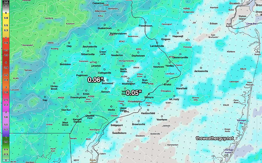
The latest forecast from the NBM shows a bit more rainfall tonight than previous forecasts—
Latest NBM model forecast 00z , just available. Accumulated rain tonight (Click on image for a larger view.)
The front comes through tomorrow morning around daybreak with clouds breaking for sunshine by 9-11 AM and winds picking up late morning.
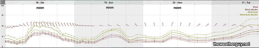
With a strong pressure gradient from the intensifying low pressure off the New England coast, our winds will be the big story on Saturday and to some extent Sunday.
NBM Wind Meteogram for location Blue Bell, PA (Click on image for a larger view.)
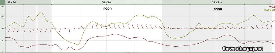
As mentioned last night, I’ve begun playing with the RRFS model still under development. Here’s its wind forecast for the weekend—
Today’s 18z RRFS wind forecast for Blue Bell PA. Somewhat more windy the forecast by the NBM. (Click on image for a larger view.)
Saturday
Cloudy early, then sunshine breaks out about 9-11 AM, earlier far west. Windy. High Temperatures will occur about noon, then decline
High temperature 55º ( NBM model— location Blue Bell, PA) High temperature 57º ( NBM model— location Philadelphia, PA) Uncertainty ± 1.7º which is average.
Sunday
Sunny and still somewhat windy. For the start of the Philadelphia Marathon 37º at 7 AM. By 10 AM 47º Still windy with gusts to about 18 MPH by 11 AM.
High temperature 53º ( NBM model— location Blue Bell, PA) High temperature 55º ( NBM model— location Philadelphia, PA) Uncertainty ± 1.3º which is higher confidence.
A large storm expected Tuesday through much of Wednesday with rainfall about 1.3″ in much of the area.
Week’s Weather Update- Philadelphia Marathon Outlook
Updated Thu 11/16 @ 5:22 PM — The approaching cold front Friday will bring clouds and should be considerably cloudy (high level cloudiness- cirrus) between 1 and 3 PM from the city westward.
High temperatures on Friday will be 65º (Blue Bell) and 67º (Philadelphia) with a higher than usual uncertainty of ± 2.4º due to differences in cloud cover forecasts.
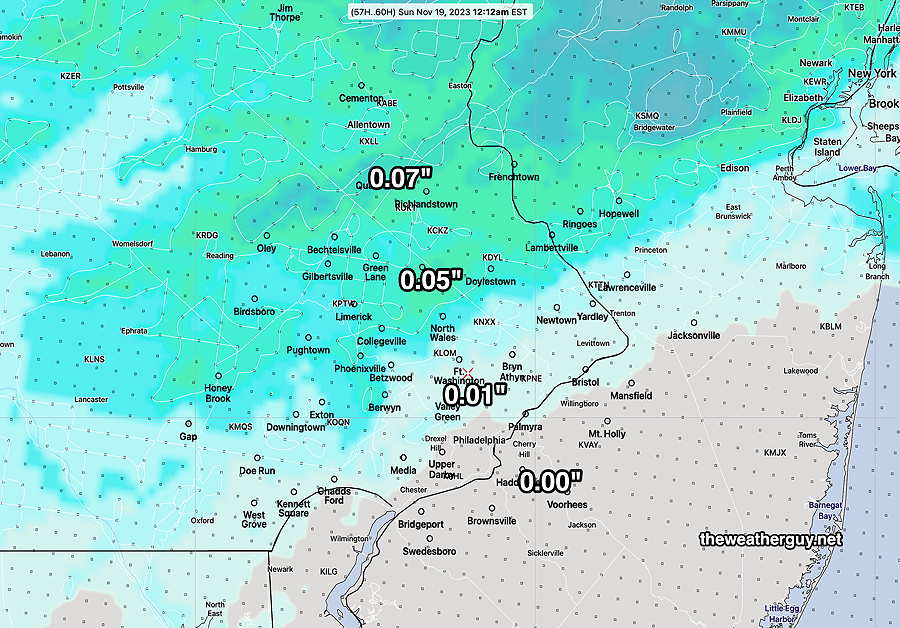
As has been the forecast trend, our immediate area will receive little to no rain from this system. Here’s the latest NBM rain totals—
Today’s 18z NBM accumulated rainfall (Click on image for a larger view.)
The forecast for the Philadelphia Marathon on Sunday is mostly unchanged.
Sunday Philadelphia Marathon Outlook — Mostly sunny early. Temperatures somewhat colder at the start- 37º early, rising to 46º in the city between 8 AM and 11 AM. Highs low to mid 50s. Winds 11 mph gusting to 20+ mph by late morning from the W.
The longer range forecast shows a good chance of rain on Tuesday.
Something that I’ve mentioned over the past year: NOAA has been developing a new model, the RRFS (“Rapid Refresh Forecast System“) which is going to be beginning of a major advance in high resolution weather forecasting. The model will run hourly, will have a 3 km resolution, and its forecasts will extend out to 60 hours. It will also have an statistical ensemble component.
The RRFS takes much of its physics from the HRRR and will use the FV3 core used in the recently updated GFS.
This RRFS is going through a series of testing and fine tuning and the groundwork is being laid for it to be operational around September 2024.
Of great relevance, about 6 months after it is released, many of the models I look at regularly (NAM, NAM-NEST, RAP, SREF, all three flavors of the HIRESW) will cease operation.
My mantra “Never Ignore the NAM” will become a thing of the past.
I’ve always felt there are “too many models” and it appears that the RRFS is incorporating all the best approaches to numerical weather modeling that have been distilled out from these earlier models.
NOAA/NWS has been making the development version and their testbed variants available on a NOAA- Amazon Web Services site (AWS) for some time.
In recent weeks, I’ve been experimenting with downloading these RRFS runs. AWS has certain restraints that the main NOAA NOMADS site doesn’t have, along with different directory structures (buckets). Nonetheless, I hope to be downloading and using the RRFS model in some winter forecasts soon.
The RRFS version 1 release will truly be a big deal. I’ll be posting more information in coming weeks.
Week’s Weather Update- Philadelphia Marathon Outlook
Updated Wed 11/15 @ 8:56 PM — We had a bit more cloudiness than forecast today.
Thursday should be quite nice, with sunny skies and warm temperatures, 63º in Blue Bell and 65º in Philadelphia.
Friday will be mostly cloudy by noon but still mild.
As discussed previously at length in previous updates, it does appear that there will be little rainfall in Philadelphia with the passage of a cold front Friday night. At most, the models, including the ensembles, crank out 0.10 inches and many show even less rain.
Saturday clears in the morning. Very windy conditions expected.
NAEFS forecast for 7 AM Saturday with previous 6 hour accumulated rainfall. (Click on image for a larger view.)
Sunday Philadelphia Marathon Outlook — Mostly sunny early. Temperatures somewhat colder at the start- 37º early, rising to 46º in the city between 8 AM and 11 AM. Highs low to mid 50s. Winds 13 mph gusting to 20+ mph by late morning from the W.
Week’s Weather Update- Philadelphia Marathon Outlook
Updated Tue 11/14 @ 5:57 PM — No change in the forecast since this morning. Thursday and Friday now look dry. The “ensemble” models (GEFS, NAEFS, GEPS) still crank out about 0.20″-0.40″ of rain Friday night into Saturday morning. The “deterministic” models (ECMWF, GFS) have the energy transferring to the low pressure system east of us, with little or no rain here. The forecast of the Philadelphia Marathon on Sunday remains unchanged.
Updated Tue 11/14 @ 9:12 AM — As has been the case many times over the past several months, the dip in the jet stream forecast for this weekend is now expected to be less amplified and the coastal system (and its associated rain) may totally miss us as the energy from the approaching cold front skips over us to our northeast. The latest ECMWF and ICON models support this scenario—
00z ECMWF shows the storm to our east with later secondary development to our northeast. The rain misses us! (Click on image for a larger view.)
We could really use the rain. If this keeps up, could we have another almost snowless winter?
Sunday Philadelphia Marathon Outlook — With a less amplified trough, expect more sunshine and less wind than my previous forecast. Mostly sunny early. Partly cloudy in the afternoon. Temperatures 39º early, rising to 46º in the city between 8 AM and 11 AM. Winds 10mph gusting to 20mph by late morning from the WNW.
Week’s Weather Update- Philadelphia Marathon Outlook
Updated Mon 11/13 @ 7:33 PM — The latest models have slowed down the movement of the coastal system as it interacts with the trough and cold front. It now appears that clouds, originally expected to move in on Thursday will move in on Friday.
With less cloudiness, high temperatures for Thursday will be in the low 60s and probably mid 60s by Friday.
The amount of rainfall with the next system, Friday into Saturday, now appears to be less than previously thought, with some models having the rain skip past us. The Ensemble models are forecasting about 0.40 inches of much needed rain, but the GFS is less impressive and the Canadian even less so.
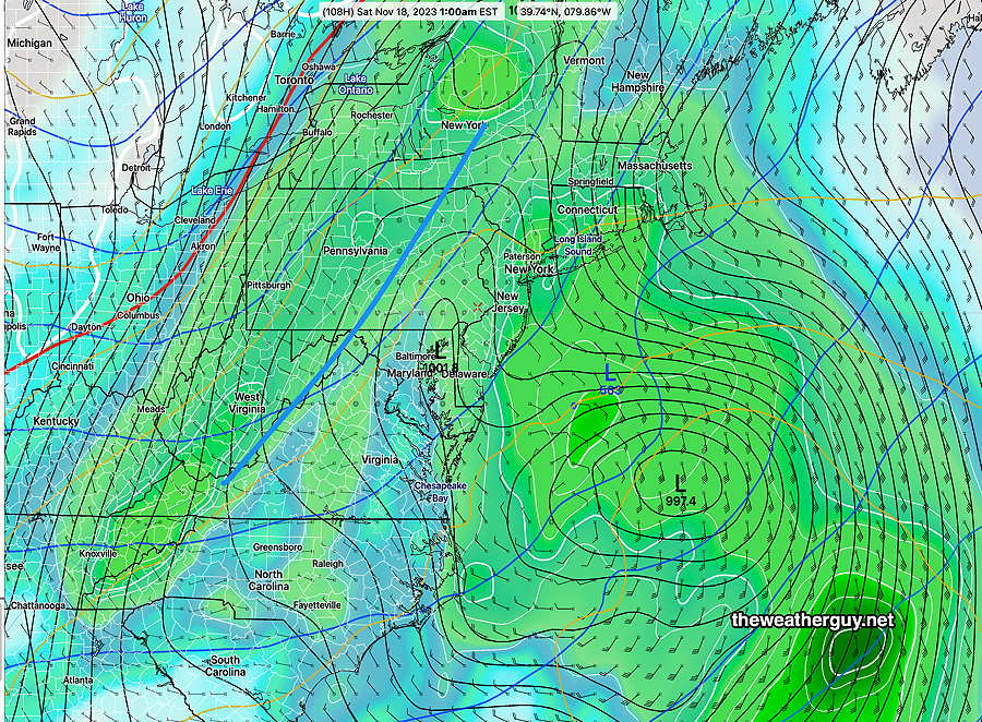
Here’s the latest NAEFS with GEFS precip, just available, for Friday night (1 AM Sat) —
Combined 18z NAEFS (mode version) forecast with Bias-Corrected GEFS model 6 hour precip for Friday night 1 AM Complex interaction of coastal system with approaching upper trough and cold front (blue line) (Click on image for a larger view.)
The interaction between the trough and coastal low appears to be be a challenge and it’s too early know how it will play out.
Sunday Philadelphia Marathon Outlook — Here’s the current outlook for Philadelphia, Sunday morning. Partly sunny early. Increasingly cloudy by late morning. Temperatures 39º early, rising to 46º in the city between 8 AM and 11 AM. Quite windy, especially by late morning. Chance of a sprinkle early afternoon.
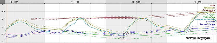
Updated Mon 11/13 @ 9:09 AM — Nice weather continues through Thursday with a slow increase in high temperatures—
Today’s 12z NBM shows high temperatures somewhat steady until Thursday. (Click on image for a larger view.)
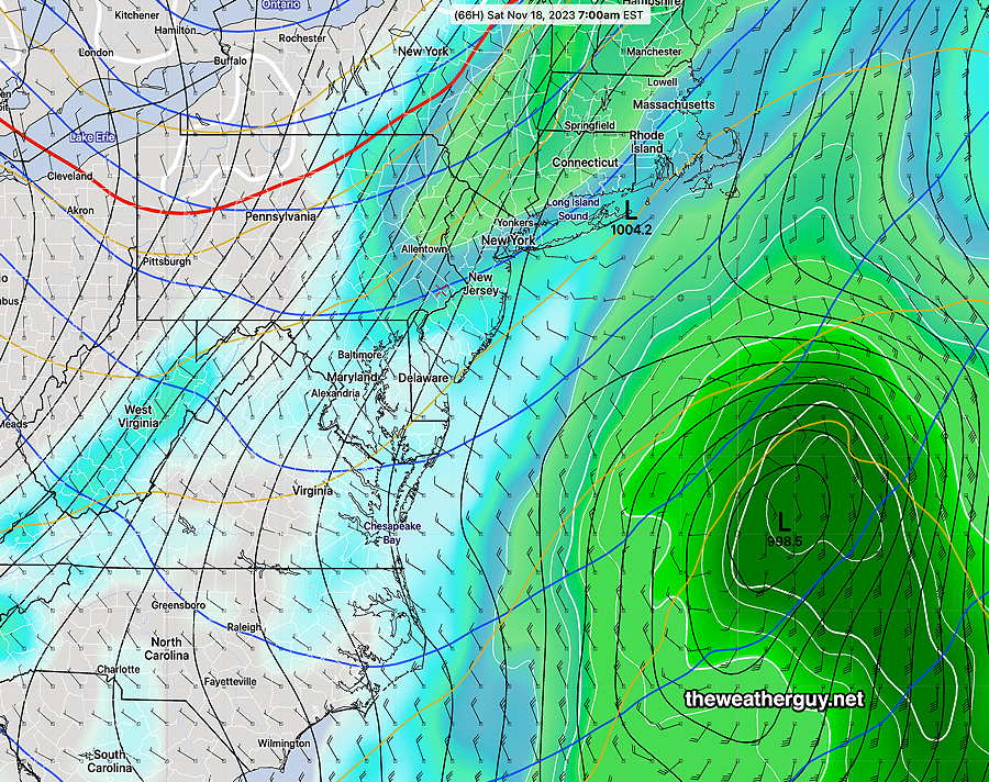
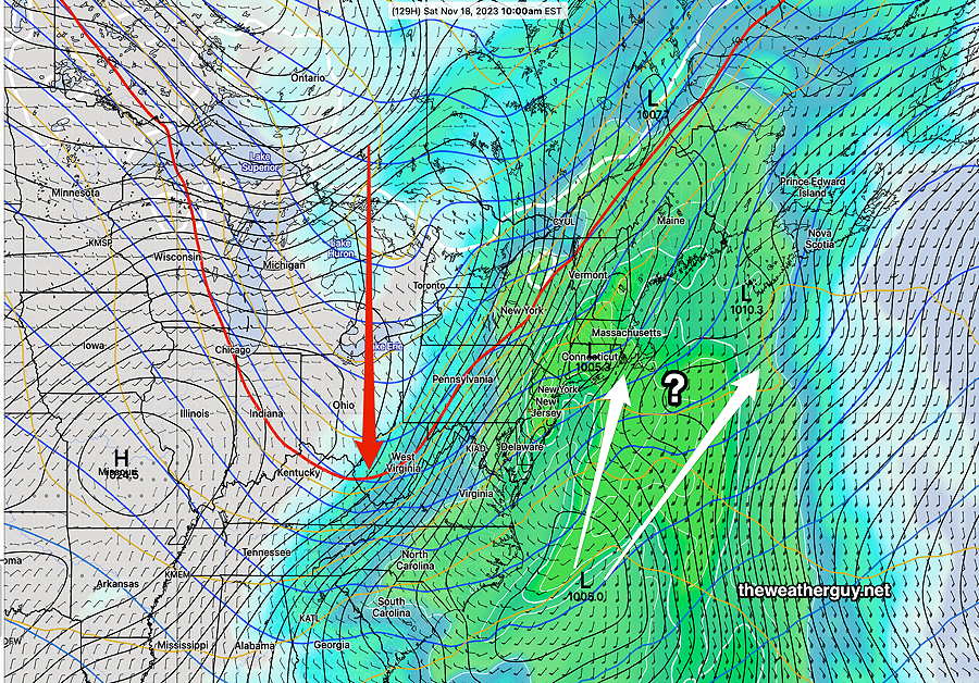
It looks like clouds move in Thursday afternoon ahead of the next system and cold front. There’s a range of model forecasts, depending upon how deep the plunge of cold air makes it southward—
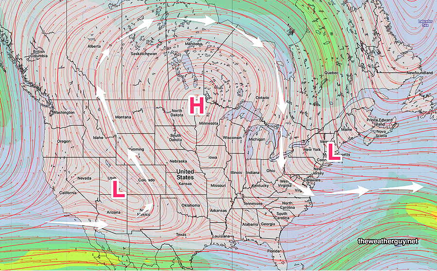
Today’s 06z NAEFS forecast for Saturday morning shows a moderate plunge of cold air (red arrow and red 540 thickness contour) and the track of the coastal storm (white arrows) (Click on image for a larger view.)
The sharper the trough dip, the more westward the storm track and the longer it affects our weather on Saturday. It will also greatly affect whether we get a soaker or another light precipitation event.
Too early to see a trend with this storm, but the recent history over past months is for the storm to be eastward, therefore, less rainfall and some clearing on Saturday afternoon.
Previously Posted Sun 6:52 PM —
Large sprawling high pressure will dominate our weather through late Thursday. Nothing much is happening here, weather-wise. Continued fair with gradually moderating temperatures into the end of the week.
Commentary — As much as I enjoy nice weather and I enjoy following the weather, it’s periods like these where I’d hate to be a full time meteorologist, on-TV or otherwise. (Ok, they make good money.)
There’s simply nothing happening; the weather has been uneventful for several weeks and will remain that way this week.
How long can one harp on normal-range colder temperatures or want to be thanked for forecasting a warmup later in the week?
Now that I got that off my chest, our next weather event is Friday, as a cold front moves through. It may become interesting where a semi- tropical system affecting Florida this week moves up the coast, causing rain to linger into Saturday. Lately all of those scenarios have fizzled, with the storm staying east in the Atlantic.
We could really use some rain.
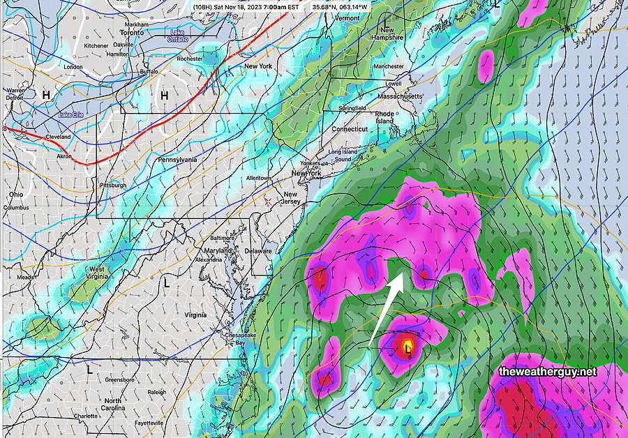
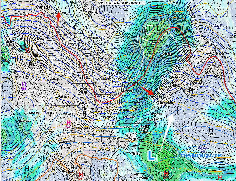
Here’s the latest NAEFS forecast for Friday—
Today’s 12z NAEFS forecast for Friday, shows low pressure off the Florida coast with a sharp dip in the jet flow and a cold front whose general position is the red 540-thickness line. Notice how the warm air is all the way up into Alberta Canada in this highly amplified jet flow. (Click on image for a larger view.)
So no rain until later on Friday and mostly sunny skies.
Winter Outlook Discussion —Which brings me to the winter forecast. Frankly, I think we’re going to see large swings in temperatures here with primarily mixed precipitation events here. Not necessarily large accumulation snow storms.
The jet pattern these past several months has been somewhat different than last year. With almost no accumulating snow last year, it’s unlikely to be similar, but it doesn’t mean we’re “due” for big snow storms.
Last winter, a persistent dip in the jet had the main axis of the trough directly over us, causing storm formation to occur in the Atlantic. This year, I ‘m seeing more favorable positioning of the axis of the jet dips (more to our west), but favoring warm air preceding any storm. The major storm developments over recent months have all been to our north and east, missing us. Will that continue?
Patterns change; what we have now could be different in January. But the trend towards warmer temperatures may be an increasingly large factor when it comes to getting large snow storms here.
Update Fri 06/02 @ 9:10 AM — Despite reasonably high CAPE and thermal instability, the lack of soil moisture feedback and marginal available precipitable water (PWAT= 1.3″) will result in a low degree of shower activity Friday afternoon.
Very widely isolated/scattered activity as early as 3-4 PM lasting until about 2 AM Saturday morning.
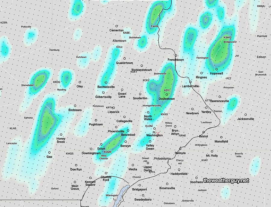
Here’s the HRRR total accumulation forecast—
HRRR total precipitation by 2 AM Saturday. Totals are in the range of 0.00- 0.16 inches (Click on image for a larger view.)
Outlook for Saturday— periods of clouds with periods of sunshine. Low probability of any showers. Cooler.
Friday Forecast Update
Update Thu 6/01 @ 10:38 PM —Tonight’s models just coming in show widely scattered showers and thunderstorms moving down from the north Friday afternoon. Peak time about 5-6 PM but possible as early as 3 PM. Widely scattered is the operative word. There’s enough CAPE and thermal instability, but not very high available moisture. Minimal shear and little jet stream support. Not a drought buster.
Update Thu 06/01 @ 4:30 PM — Most models are forecasting high temperatures around 92º-93º on Friday afternoon.
That said, the ECMWF, German ICON and Canadian HRDPS are showing some suburbs of Philadelphia reaching 95º-96º.
The NBM which is designed to iron out differences in the model forecasts is showing 92º but with a high standard deviation of ± 3.2º.
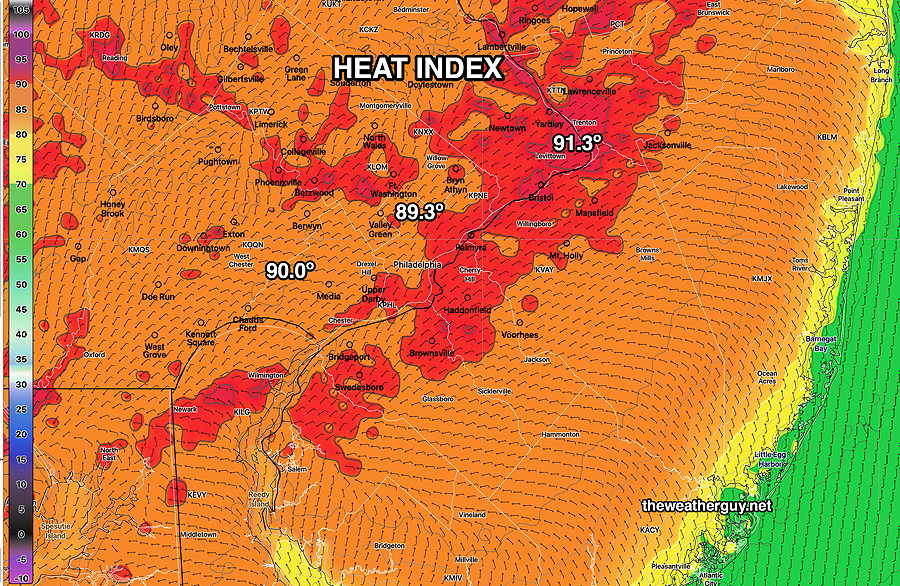
Interestingly, the dew point temperatures will be low, so the heat index (“apparent temperatures”) will likely be lower than the air temperature.
NBM Apparent Temperatures at 3 PM Friday (HEAT INDEX) (Click on image for a larger view.)
It appears that a lack of soil moisture and precipitable water may significantly reduce thunderstorm development and coverage Friday evening. Much needed rain doesn’t currently appear to be a likely possibility in many areas.
Possibly some thunderstorms early Friday evening?
Update Wed 05/31 @ 5:35 PM — The incredible weather we’ve been having is really quite perfect, BUT there’s been a significant deficit in rainfall in may areas, especially from Philadelphia and the suburbs immediately westward.
The backdoor cold front expected Saturday could produce some light showers.
Today’s higher resolution models are suggesting the possibility of some thunderstorms late Friday afternoon or early evening in advance of the front.
(There will be plenty of heat and CAPE available for thunderstorm formation on Friday. Precipitable water is expected to increase to 1.7″. Missing will be soil moisture, which tends to enhance convective activity.)
The NAM-NEST model is showing a few scattered storms early Friday evening, mostly to our far north and more later in the evening.
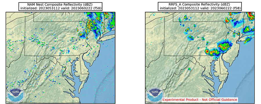
Just out of curiosity, I took a look at the experimental RRFS (Rapid Refresh Forecast System) model under development and scheduled for release the end of this year.
Here’s a comparison of the NAM-NEST and the experimental RRFS at 6 PM Friday—
The RRFS is showing a thunderstorm cluster over Philadelphia Friday at 6 PM. It will be interesting to see if this model forecast holds. (Click on image for a larger view.)
Ninety Degrees Plus on Friday. Light showers possible Saturday
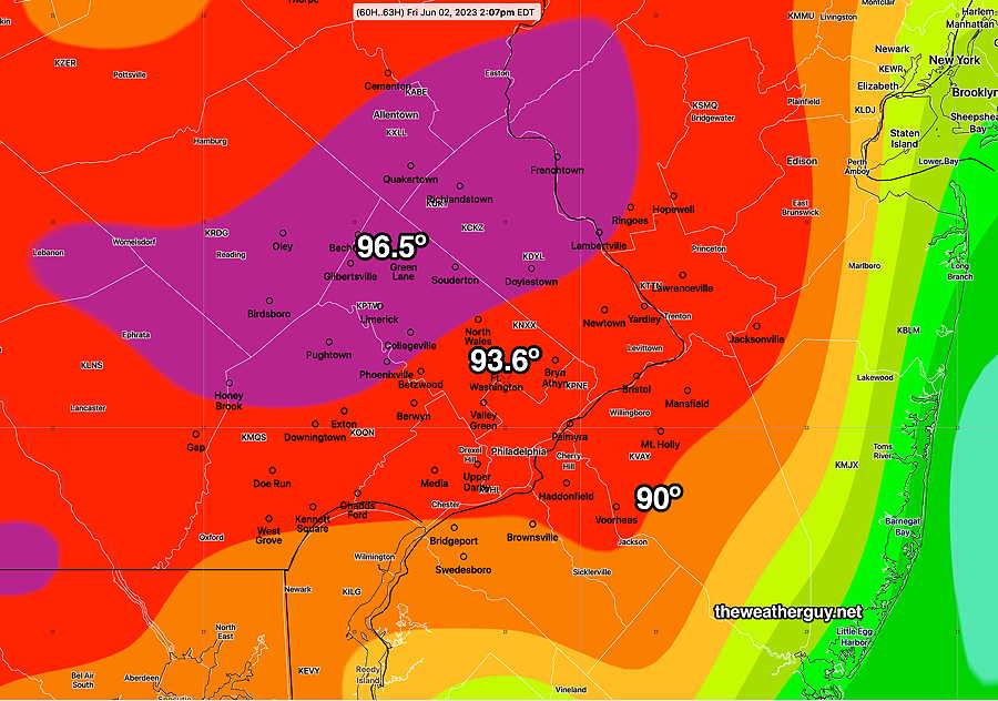
Update Wed 05/31 @ 9:39 AM — The upper level ridge will move eastward enough on Friday to give us some true summer temperatures. There’s a range of forecast high temperatures, but here’s the latest ECMWF and NBM to give a sense of what’s expected—
Lastest ECMWF high temperatures forecast for Friday (Click on image for a larger view.)
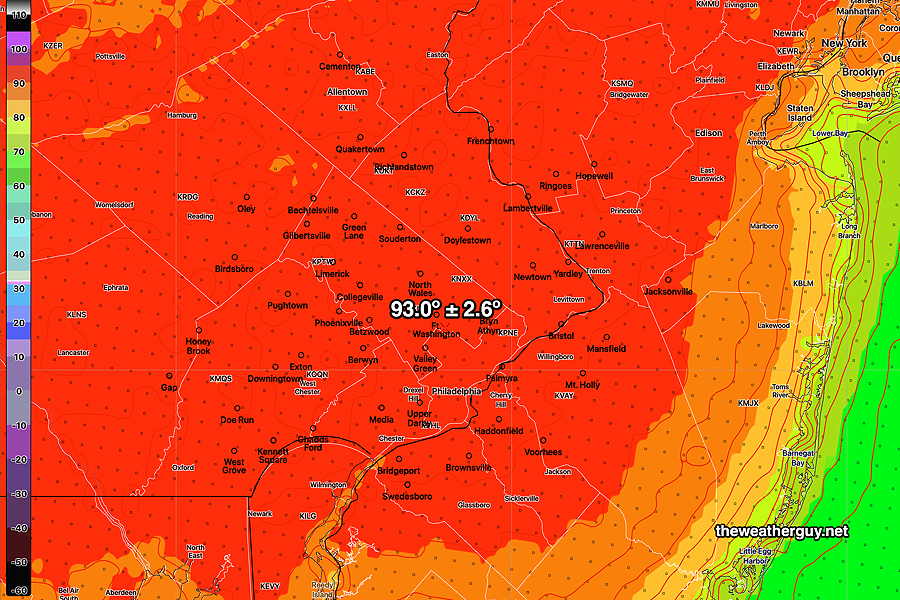
Here’s the NBM model version 4.1 forecast which is a weighted average of over 40 models, weighted based on the model’s most recent 6 hour performance—
Today’s 12z NBM model high temperature forecast with standard deviation shown as ±. (Click on image for a larger view.)
Dew point temperatures will be relatively low (60º or less) so the actual “apparent temperature” (“heat index”) will not be that high (less than 90º in most areas.)
For Saturday, a back door cold front moves through. Most models are showing light showers mid-day with about 0.2-0.3″ of rain. Not very much, but we’ll take it. With soil moisture so low, we’ll see if we even get that much.
Blocking Pattern Retrogrades. Expect 90º on Friday
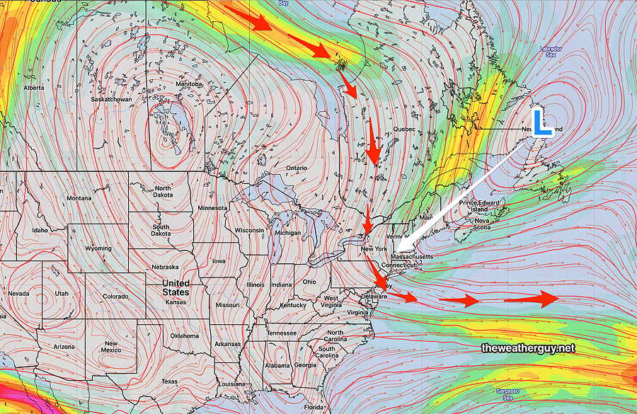
Update Tue 05/30 @ 11:50 AM — Not only is the blocking pattern expected to persist this week, but the latest GFS has joined the ECMWF in showing a deepening of the upper low over the Newfoundland and a retrograde of the entire block westward—
ECMWF jet stream forecast for Saturday shows a strengthening of the upper level low near Newfoundland over with it extending further southwestward (retrograde) with the entire block circulation retrograding westward.
Following 90+º temperatures here on Friday, the retrograde will cause a backdoor cold front to move across us Saturday. The last two days of the ECMWF model shows a bullseye of rain with this backdoor cold front over us on Saturday. The GFS has joined the ECMWF with this forecast, but has significantly less rain for us.
Following the backdoor cold front, we cool down significantly for Sunday.
Previously Posted Mon 9:24 AM —
Blocking Pattern Entrenches
It’s been over three weeks since the immediate Philadelphia area has had any significant rain.
While the term “pattern” is sometimes loosely used regarding weather changes, this is beginning to look like a true persistent pattern for our area, all the result of a relatively unchanged, blocked upper air configuration.
Over past weeks, I’ve used the terms Omega Block and Rex Block to describe the upper air configuration that is resistant to change.
The latest ICON ensemble (ICON-EPS) clearly shows we’re heading into a combined Rex block and large scale Omega block for the end of this week—
ICON-EPS (ensemble) mean 250 mb Heights (jet stream summer level winds) forecast for this Friday. (Click on image for a larger view.)
The GFS ensemble (GEFS) shows a similar Omega block configuration without the Rex Block—
GEFS 250 mb mean Wind forecast (summer jet stream level) (Click on image for a larger view.)
What does this all mean? Well, what we have weather-wise is essentially what we will be getting through at least the next week or so— Beautiful, cooler to near average weather with little-to-no chance of rain.
The center of the US will be in the very warm (hot) sector of the block, but we’ll be in the cooler part of the block, influenced by the upper low pressure system.
As I’ve expressed over the past week or two, I’m concerned that this may progress into a significant dry period (short term drought) for the immediate PHL region.
Patterns change, often without advance notice, but for now this is what we’ll see. The NAEFS suggests we may get some light rain the end of NEXT week (June 7-10th time frame.)