Category Archives: Basic Weather Facts

NEW GFS MODEL VERSION 16.3 TO BECOME OPERATIONAL

NOAA and the National Weather Service announced today the upcoming release of a new GFS model version 16.3. The GFS model, our global deterministic model and our major model, will be upgraded from the current version 16.2.2 to version 16.3 on November 29th.

Version 16.3 will feature major enhancements in input data and significant corrections to snowfall accumulation forecasts (which have been over-forecast in warm situations and under-forecast in colder situations.)

Enhancements in data will include significant new input data as well as data refinements from satellites that input upper air winds, temperature and humidity measurements. Satellite radio occultation data will also be enhanced.

Several models (NAM, RAP, URMA, GDAS) use the same model assimilation input as the GFS. These models will also have their data input enhanced as of November 29th.

As NOAA often does, it has pre-released the new version 16.3 today and I will be using the new version going forward.

Tomorrow’s regular WEEKEND WEATHER FORECAST, will feature the new GFS and where interesting, I’ll compare its forecast to version 16.2.2

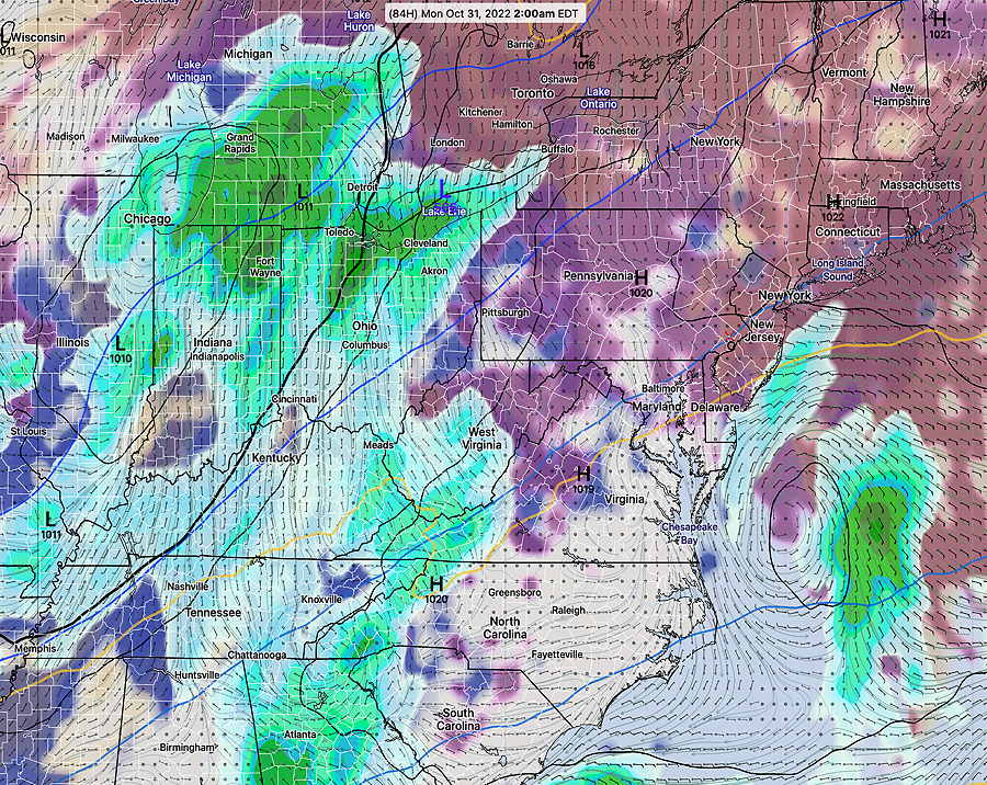
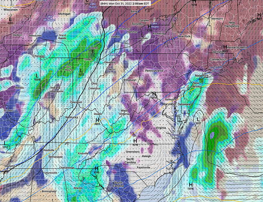
Example of forecast differences—

Current GFS Version (16.2.2) Forecast for Late Sunday night—

Current GFS version 16.2.2 Forecast for 2 AM Monday, showing rain and clouds. Notice the rain is off the New Jersey Coastline. (Click on image for a larger view.)

Compare to the new just released version GFS 16.3—

NEW GFS 16.3 forecast for 2 AM Monday. Notice this model version shows considerably more rain over NJ and into Philadelphia and low pressure is much closer to the coastline. (Click on image for a larger view.)

I guess I’m a true weather nerd; I get truly excited about a new weather model and the prospect of improved forecasts.

Of course, whether or not we’ll see an improvement in the forecasts, only time will tell. But I have incredible respect for the atmospheric scientists and true meteorologists at NOAA.

By the way, GFS version 17.0 is slated for the 4th quarter of 2024.

HOW TO GET NBM TEXT DATA

One reader wanted to know how to get the latest hourly probability of precipitation for our area.

One of the best ways is a direct link to the NBM (Model Blend) text output. The NBM is considered the best model for rain probability and the model data from this link is updated every few hours.  (Yes, the NBM model is updated every hour, but to get the absolute latest, you’d have to dive into the bowels of the NOAA NOMADS server.)

I’ve pre-configured the URL for you to provide the model output for Philadelphia Airport, Wings Field Blue Bell, and Northeast Philadelphia airport—

https://www.weather.gov/mdl/nbm_text?ele=nbs,nbe,nbh&sta=klom,kphl,kpne

The one you want to focus on is the NBH ( H= hourly).

It provides hourly probability (P01) in percentage (on an hourly basis, anything greater than 18% and increasing is meaningful) and the amount (Q01) in hundredths of an inch. 

It’s important to know, that with accumulated rainfall, the number refers to amount having accumulated in the preceding hour.

The tricky part is converting to the UTC time to Eastern Standard or Eastern Daylight time. 

The example below is for KLOM, Wings Field, Blue Bell.

So in the example below, this is the NBM model run is from 0700 UTC (3 AM EDT).  The first row (labeled UTC)  are the forecast hours and the column labeled “14” is the UTC TIME forecast time. So  14UTC = 10 AM EDT (or 9 AM EST).

Looking down the 1 hour probability (P01) is 48% and the quantity of rain fallen in the preceding hour (Q01) is 2.   2= 0.02″

Beware that for some of the other data displayed, especially in the NBE, the meaning can less less than intuitive.  In the NBE, the column labeled, as an example,  00 day FRI, refers to the 12 hours PRIOR to 00z Friday which means daytime THURSDAY!