Tag Archives: Omega Block

THIS WEEK’S WEATHER

#weather #paweather #wx #pawx #philadelphia #phillywx

Shower Forecast Update

Update Fri 06/02 @ 9:10 AM — Despite reasonably high CAPE and thermal instability, the lack of soil moisture feedback and marginal available precipitable water (PWAT= 1.3″) will result in a low degree of shower activity Friday afternoon.

Very widely isolated/scattered activity as early as 3-4 PM lasting until about 2 AM Saturday morning.

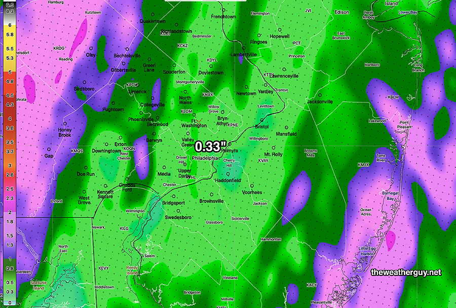
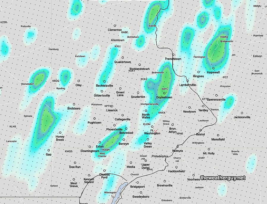
Here’s the HRRR total accumulation forecast—

HRRR total precipitation by 2 AM Saturday. Totals are in the range of 0.00- 0.16 inches (Click on image for a larger view.)

Outlook for Saturday— periods of clouds with periods of sunshine. Low probability of any showers. Cooler.


Friday Forecast Update

Update Thu 6/01 @ 10:38 PM —Tonight’s models just coming in show widely scattered showers and thunderstorms moving down from the north Friday afternoon. Peak time about 5-6 PM but possible as early as 3 PM. Widely scattered is the operative word. There’s enough CAPE and thermal instability, but not very high available moisture. Minimal shear and little jet stream support. Not a drought buster.


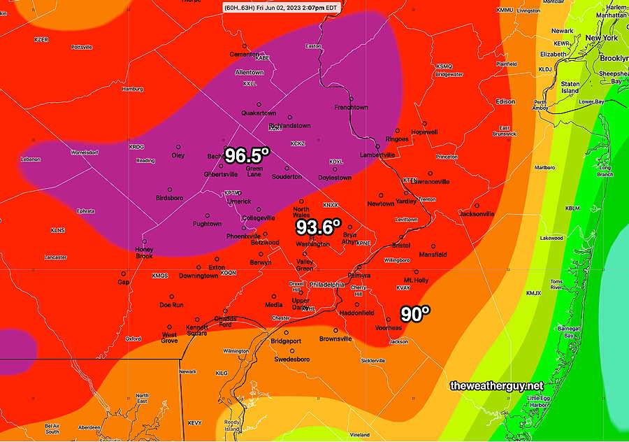
Update Thu 06/01 @ 4:30 PM — Most models are forecasting high temperatures around 92º-93º on Friday afternoon.

That said, the ECMWF, German ICON and Canadian HRDPS are showing some suburbs of Philadelphia reaching 95º-96º.

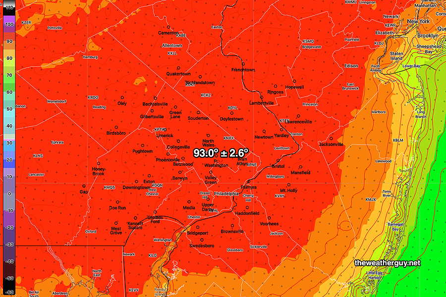
The NBM which is designed to iron out differences in the model forecasts is showing 92º but with a high standard deviation of ± 3.2º.

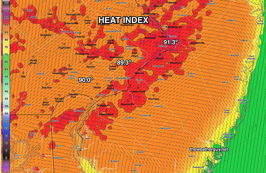
Interestingly, the dew point temperatures will be low, so the heat index (“apparent temperatures”) will likely be lower than the air temperature.

NBM Apparent Temperatures at 3 PM Friday (HEAT INDEX) (Click on image for a larger view.)

It appears that a lack of soil moisture and precipitable water may significantly reduce thunderstorm development and coverage Friday evening. Much needed rain doesn’t currently appear to be a likely possibility in many areas.


Possibly some thunderstorms early Friday evening?

Update Wed 05/31 @ 5:35 PM — The incredible weather we’ve been having is really quite perfect, BUT there’s been a significant deficit in rainfall in may areas, especially from Philadelphia and the suburbs immediately westward.

The backdoor cold front expected Saturday could produce some light showers.

Today’s higher resolution models are suggesting the possibility of some thunderstorms late Friday afternoon or early evening in advance of the front.

(There will be plenty of heat and CAPE available for thunderstorm formation on Friday. Precipitable water is expected to increase to 1.7″. Missing will be soil moisture, which tends to enhance convective activity.)

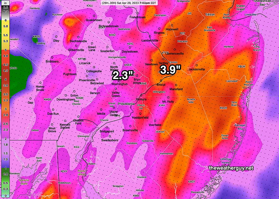
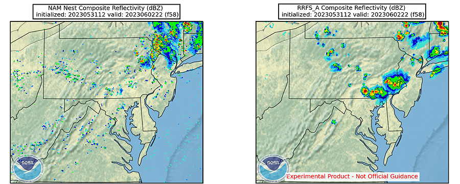
The NAM-NEST model is showing a few scattered storms early Friday evening, mostly to our far north and more later in the evening.

Just out of curiosity, I took a look at the experimental RRFS (Rapid Refresh Forecast System) model under development and scheduled for release the end of this year.

Here’s a comparison of the NAM-NEST and the experimental RRFS at 6 PM Friday—

The RRFS is showing a thunderstorm cluster over Philadelphia Friday at 6 PM. It will be interesting to see if this model forecast holds. (Click on image for a larger view.)

Ninety Degrees Plus on Friday. Light showers possible Saturday

Update Wed 05/31 @ 9:39 AM — The upper level ridge will move eastward enough on Friday to give us some true summer temperatures. There’s a range of forecast high temperatures, but here’s the latest ECMWF and NBM to give a sense of what’s expected—

Lastest ECMWF high temperatures forecast for Friday (Click on image for a larger view.)

Here’s the NBM model version 4.1 forecast which is a weighted average of over 40 models, weighted based on the model’s most recent 6 hour performance—

Today’s 12z NBM model high temperature forecast with standard deviation shown as ±. (Click on image for a larger view.)

Dew point temperatures will be relatively low (60º or less) so the actual “apparent temperature” (“heat index”) will not be that high (less than 90º in most areas.)

For Saturday, a back door cold front moves through. Most models are showing light showers mid-day with about 0.2-0.3″ of rain. Not very much, but we’ll take it. With soil moisture so low, we’ll see if we even get that much.


Blocking Pattern Retrogrades. Expect 90º on Friday

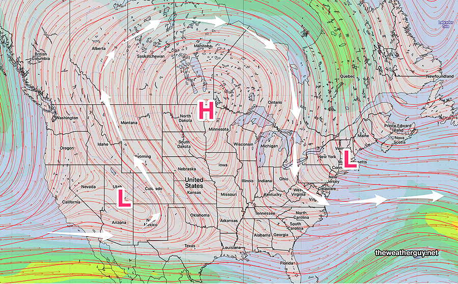
Update Tue 05/30 @ 11:50 AM — Not only is the blocking pattern expected to persist this week, but the latest GFS has joined the ECMWF in showing a deepening of the upper low over the Newfoundland and a retrograde of the entire block westward—

ECMWF jet stream forecast for Saturday shows a strengthening of the upper level low near Newfoundland over with it extending further southwestward (retrograde) with the entire block circulation retrograding westward.

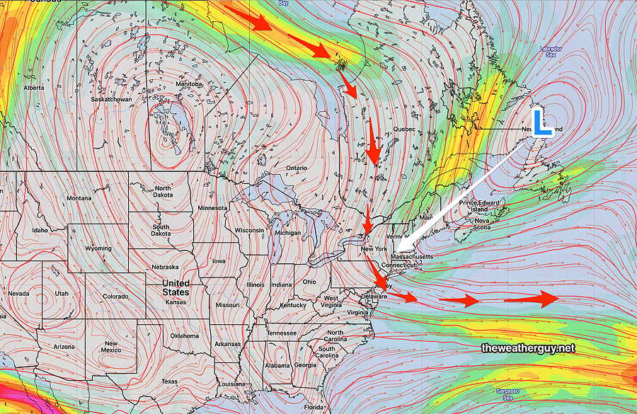
Following 90+º temperatures here on Friday, the retrograde will cause a backdoor cold front to move across us Saturday. The last two days of the ECMWF model shows a bullseye of rain with this backdoor cold front over us on Saturday. The GFS has joined the ECMWF with this forecast, but has significantly less rain for us.

Following the backdoor cold front, we cool down significantly for Sunday.


Previously Posted Mon 9:24 AM —

Blocking Pattern Entrenches

It’s been over three weeks since the immediate Philadelphia area has had any significant rain.

While the term “pattern” is sometimes loosely used regarding weather changes, this is beginning to look like a true persistent pattern for our area, all the result of a relatively unchanged, blocked upper air configuration.

Over past weeks, I’ve used the terms Omega Block and Rex Block to describe the upper air configuration that is resistant to change.

The latest ICON ensemble (ICON-EPS) clearly shows we’re heading into a combined Rex block and large scale Omega block for the end of this week—

ICON-EPS (ensemble) mean 250 mb Heights (jet stream summer level winds) forecast for this Friday. (Click on image for a larger view.)

The GFS ensemble (GEFS) shows a similar Omega block configuration without the Rex Block—

GEFS 250 mb mean Wind forecast (summer jet stream level) (Click on image for a larger view.)

What does this all mean? Well, what we have weather-wise is essentially what we will be getting through at least the next week or so— Beautiful, cooler to near average weather with little-to-no chance of rain.

The center of the US will be in the very warm (hot) sector of the block, but we’ll be in the cooler part of the block, influenced by the upper low pressure system.

As I’ve expressed over the past week or two, I’m concerned that this may progress into a significant dry period (short term drought) for the immediate PHL region.

Patterns change, often without advance notice, but for now this is what we’ll see. The NAEFS suggests we may get some light rain the end of NEXT week (June 7-10th time frame.)


WEEKEND WEATHER FORECAST

#weather #paweather #wx #pawx #philadelphia #phillywx #broadstreetrun

Sunday Forecast Update

Update Sun 04/30 @ 4:24 PM — Areas of very heavy rain continue, especially in New Jersey, where large areas have received close to 5″ of rain since Friday. An additional inch or more is possible!

The latest HRRR shows some heavy downpours with thunderstorms possible between 8 PM and midnight ahead of a cold front passage.

The actual cold front will move through between 10 PM and midnight and periods of heavy rain will continue through the frontal passage.

Wind gusts may exceed 55 mph in some areas around midnight as a pressure gradient develops with the departing low pressure system.


Show More

Previously Posted Fri 5:19 PM —

Sunday

Spotty rain develops during the morning and becomes heavy during the mid afternoon. An additional 1.25 inches of rain possible. Milder. Windy and gusty.

High temperature 63.8.º sd 1.5º ( NBM model location Blue Bell, PA)

Winds
NBM forecast winds and wind gusts (with standard deviation) for location Blue Bell, PA Wings Field.


WEEKEND WEATHER OUTLOOK

#weather #paweather #wx #pawx #philadelphia #phillywx

Friday Update- Rain on the way

Update Fri 04/28 @ 9:28 AM — The latest radar has the rain somewhat closer to us than predicted by last night’s models. Nonetheless, the RAP is showing a bit of push-back of the rain advance, based on isentropic (thermal energy) analysis.

MRMS radar at 9:22 AM with superimposed RAP model 300K level Theta-E isentropes shows a bit of an energy wall to surmount for the rain to move into the PHL area, despite being just 40 miles away.

The models are still showing light sprinkles possible here about 11 AM, but the main area of rain moves in about 1-2 PM.


Rain: Parts of Friday, Saturday, Sunday

Update Thu 4/27 @ 9:08 PM — Several models have over two inches of rain falling Friday night alone.

Update Thu 04/27 @ 7:51 PM —The blocking pattern described below is setting up for this weekend and at least into Tuesday.

Rain moves in on Friday early afternoon, but some scattered sprinkles are possible during the morning.

The main slug of rain moves in from the southwest around 11AM to 1PM according to the latest GFS model—

This afternoon’s 18z GFS model forecast for 10 AM Friday. (Click on image for a larger view.)

On Friday, once the rain starts, it will become moderate to heavy at times.

The bulk of the rain will be departing on Saturday morning, but the models maintain some scattered showers around during the day, especially northeast of our area.

Heavier rain moves in on Sunday.

This weather will be generated by circulation around a upper level closed low pressure system near the Great Lakes that will remain almost stationary. Timing the breaks in the rain will be challenging as the impulses circulating the low are tough to model exactly.

We may get enough of a break Saturday afternoon to salvage the day.

Sunday doesn’t look as promising at this time.

Total rainfall may exceed 2 inches for the weekend.

I’ll try to nail it down in my regular Weekend Weather Forecast.


Update Thu 04/27 @ 10:01 AM — Updated Thursday forecast here.


Previously Posted Wed 5:24 PM —

Developing Omega Block Pattern

The upper air flow is moving towards a blocked pattern, specifically an “Omega Block” pattern. Unlike the recent “Rex” block named for the meteorologist who identified it, the “Omega” block is named for the Greek letter omega Ω because the wind flow resembles this letter.

Here’s the jet stream wind flow (at level 250 mb) for late Sunday. The Omega Ω resemblance is clearly visible—

Today’s GEFS 12z shows the forecast jet stream level (250 mb) wind flow for late Sunday resembling the greek letter Omega. (Click on image for a larger view.)

All blocked patterns result in stalled or slowly moving systems. In this case, we’ll be stalled in a cool, wet, cyclonic pattern with a closed upper low over the Great Lakes rotating disturbances towards us.

The developing block will bring rain to us by Friday afternoon. Periods of rain will be with us through the weekend and even through next Tuesday! There will be breaks in the rain and timing these breaks will be the challenge for this weekend’s forecast. It’s going to be a good weekend for ducks and flowers.

Rest of this week
Thursday

Update Thu 04/27 @ 10:02 AM — The latest HRRR forecasts even more lingering cloudiness today. We may not see any sun in the city until after 2 PM.

This morning’s 12z HRRR cloud forecast (Click on image for a larger view.)

Update Thu 04/27 @ 8:35 AM — It looks like we’ll get some sunshine about 1 PM in the city and earlier west of the city. Clouds move back in about 6 PM. High temperatures about 61º but a high standard deviation of 3.5º based on the uncertainty in the cloud cover.


Update Wed 4/26 11:06 PM — Tonight’s models have clouds and light sprinkles lingering possibly past noon.


Before we get to this pattern, Thursday should start cloudy, but considerable sunshine expected around noon. A mix of sun and clouds for the afternoon. High will be near 65º

Friday

Friday will be cloudy and rain moves in about 2-4 PM from the west.