
UPDATES
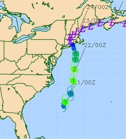
Henri Forecast Updated Sat 11:15 PM — The GFS did well with its forecast track of Henri. I should have also checked the Navy COAMPS model, which had a good handle on the track. Here’s last night’s COAMPS-
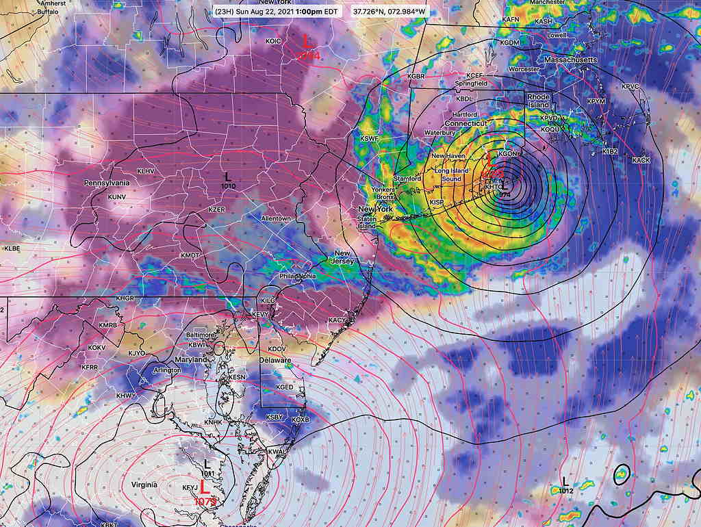
Henri Forecast Updated Sat 5:11 PM — Henri is now classified as a Hurricane.
Today’s models continue with Henri making landfall from mid-Long Island to the tip of Long Island about 11 AM to noon on Sunday. The GFS has probably been the most consistent with its track over the past day or so and the current water vapor lines up well with the current GFS forecast upper air low position—
The NAM-NEST has a similar forecast as the GFS, but is somewhat slower with landfall —
As a result of the more north-northeastern track, the impact of the storm on our area will be reduced significantly.
Still uncertain is the track of the remnants of Henri with some models having the moisture wrap westward and into northeast into NY, northern NJ and northeast Pennsylvania, possibly as far south as our area. Too much uncertainty with this right now.
With Hurricane Henri no longer a direct threat to our area, I’m going to leave the storm coverage going forward to the experts at the National Hurricane Center. This will be my final update on Henri.
Update Sat 8:35 AM — Last night’s GFS and Canadian global models have reverted to a more northerly track, with the storm moving through Long Island instead of NYC. There is still a slight jog westward into the Hudson valley area of NY. The storm is also forecast to move much faster than previously forecast. This will limit the direct impact on our area and even the south Jersey shore. Our weather on Saturday will be influenced by the unstable moist air and the upper air low as discussed below.
Update Fri 11:20 PM — The HIRESW-FV3 has a westward track into NYC, similar to the new HRRR.
Update Fri 10:50 PM — Tonight’s NAM and NAM-NEST just available continue with the consensus forecast of Henri staying east, hitting Long Island, with less impact for us.
Of interest is the HIRESW-FV3, which completes and becomes available shortly.
Update Fri 10:15 PM — Tonight’s latest short range models are just starting to come in. The HRRR and NAM show sun early on Saturday, the showers develop between 2 PM and 5 PM.
At this hour, only the HRRR model forecast through Sunday is complete.
The HRRR has joined the ICON and Canadian GEM models in forecasting a westward track jog by Henri over NYC, increasing the storm’s impact in our area. The other major models won’t be available until later. I’ll update tomorrow.
HENRI
The coming weekend’s weather will be influenced by an upper air low pressure system, the residual tropical moisture in place and the moisture and eventual track of tropical storm (hurricane) Henri.
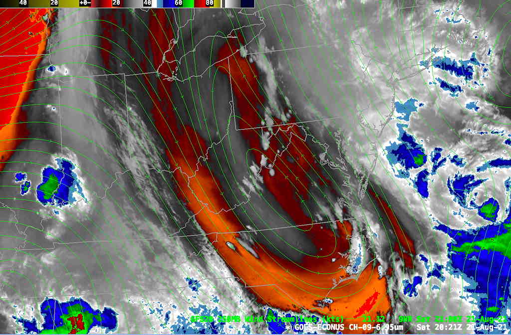
Some important and interesting features are visible in the current satellite water vapor imagery, described in the caption below—
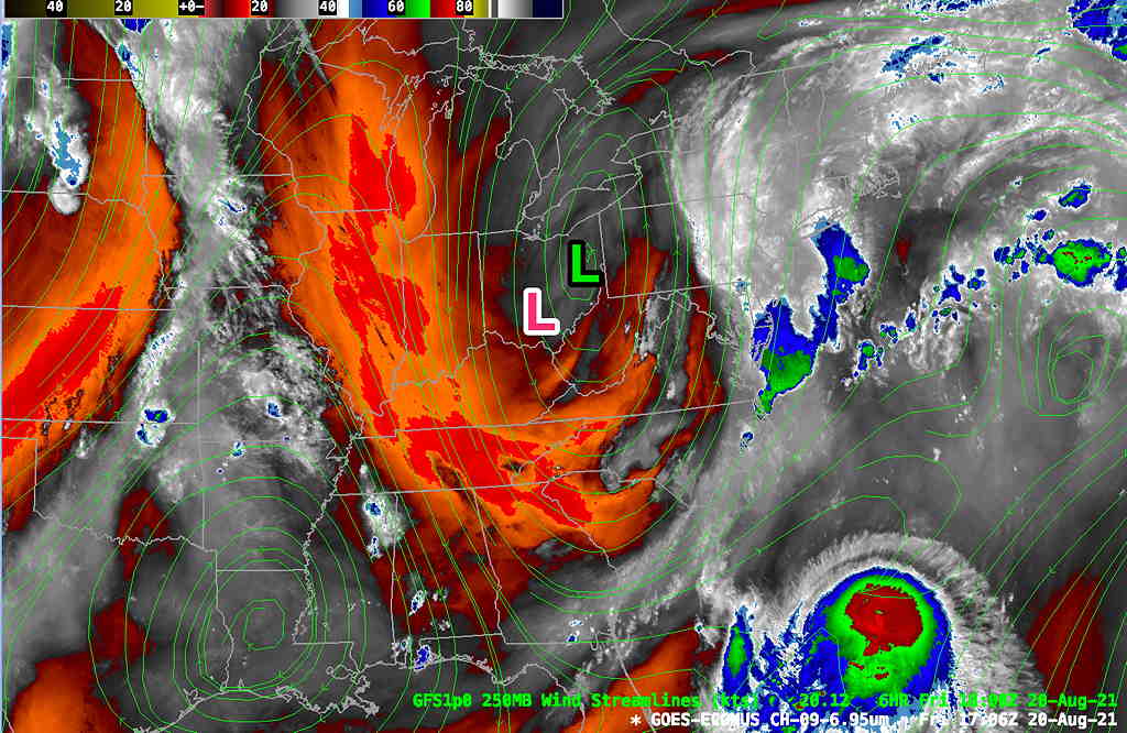
Several models have recently begun showing a westward jog to the path of Henri due to the closed upper level low will steer the storm to the west.
While fluid motion modeling is incredibly complex, it makes sense to me that a more westward upper low will steer the storm further westward.
The latest guidance shows the storm likely strengthening to a hurricane status and an increasing number of models show a track that may increasingly jog to the west and affect our area—

The latest Canadian Global GEM model is similar to the German ICON model with a landfall on Long Island and then a jog westward.

The ICON and Canadian GEM show very high rainfall amounts. Here’s the ICON model total rainfall by 11 PM Sunday—
I want to emphasize that the above ICON and GEM forecasts are NOT now considered the official track of the storm. There is much uncertainty. I am presenting them because I think they’re leaning in the right direction.
FOR THE OFFICIAL FORECAST, ALWAYS USE THE NWS TROPICAL PREDICTION CENTER.