Not Forecasts – Just Thoughts, Conjecture and Speculation about possible upcoming storms and trendsin the extended range.
Coverage of each potential storm will move to the main forecast blog pagewhen the possibility of a storm moves from speculation to probable/likely.
#Philadelphia #weather #PAwx
No Snow for through at least March 5th
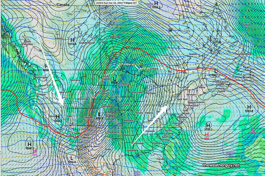
Posted Friday 02/23/24 @ 7:48 PM — A rapidly changing progressive jet stream flow with an increasingly warm bias and recurrent ridging in the Eastern US looks to to be the case through the first week in March. A couple of chill downs with cold fronts, but quick rebounds to above average seasonal temperatures.
We also seem to have broken away from the extreme rainfall storms for now with blocking high pressure in the western Atlantic. This is feeling like a pattern change for us that may extend into Spring.
02-23-24 18zNAEFS forecast for March 3rd captures the general pattern. Recurrent eastern ridge with warm temperatures. High pressure anchored off the coast blocking low pressure systems that will move up through the Great Lakes.
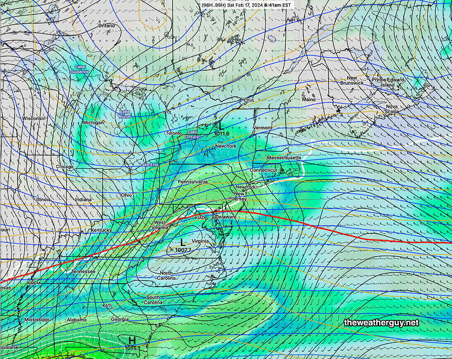
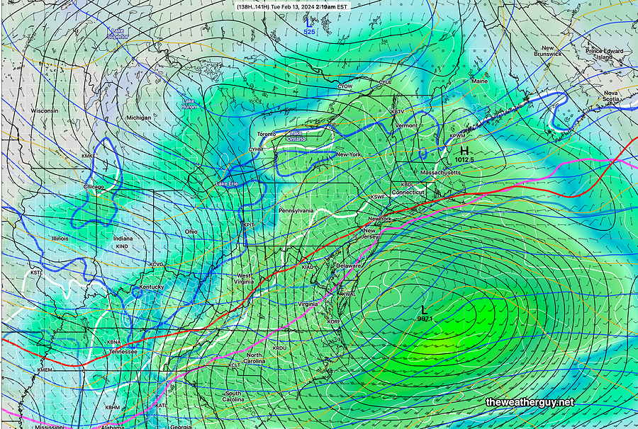
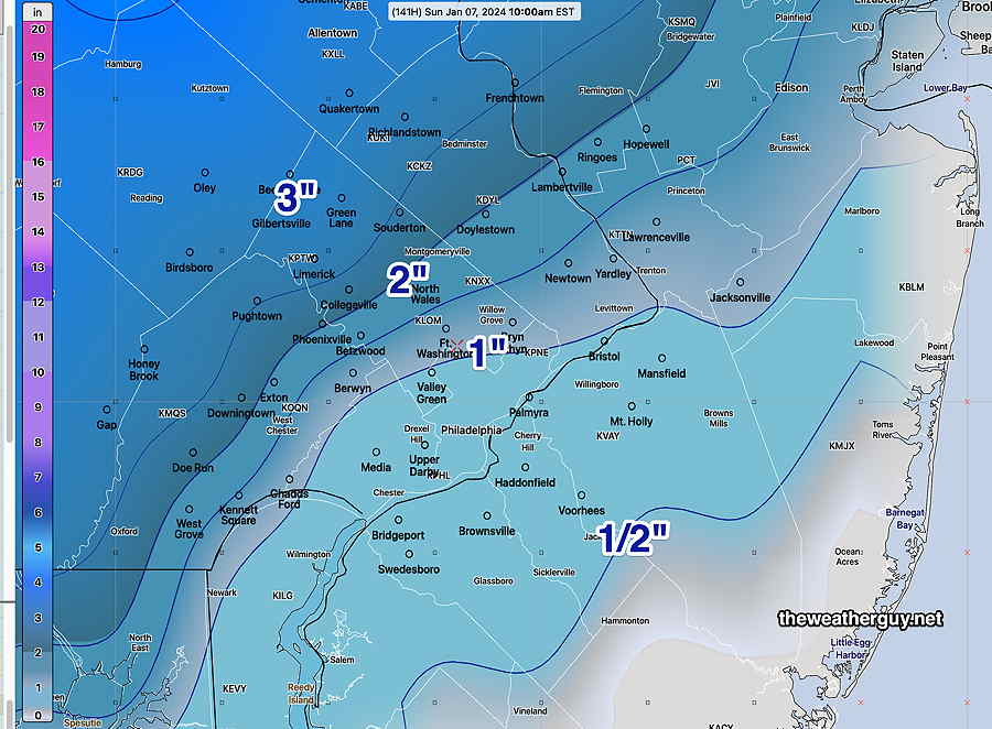
Posted Tuesday 02/13/24 @ 3:18 PM — Previous outlooks have focused around this time period. The potential storm Feb 18th to 19th currently looks like it will pass to our south. However, a lead disturbance looks like it will bring snow here Friday night into Saturday morning—
02-13-24 12z NAEFS statistical “mode” version model combined with GEFS “bias-corrected” precipitation model forecast for Saturday morning. shows low pressure moving to our south. Snow likely with this system. Whether the disturbance further south moves up the coast is still a possibility, but looking less likely. (Click on image for a larger view.)
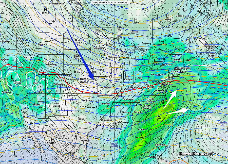
Posted Saturday 02/10/24 @ 5:32 PM —The potential storm for Monday Feb 19th appears to have moved up a bit to the 18th. This storm has the potential for snow in our region, but the track towards us would require a much more amplified jet trough developing to our west. Just speculation, as are all the comments on this page.
Next Potential Storm Feb 18-19th
02-10-24 12z GEFS shows a potential snow storm for us Sunday the 18th, IF the cold air (blue arrow) amplifies the upper air trough more than currently forecast. (Click on image for a larger view.)
Next Potential Storm – Monday Feb 19th.
Posted Thursday 02/08/24 @ 7:53 PM — A stalled front and plenty of cold air for this potential storm 10 days in the future.
02-08-24 18z NAEFS for Monday Feb 19th. Potential coastal storm. (Click on image for a larger view.)
Increasing Signal for Some Winter-like Weather Feb 13th
Posted Wednesday 02/07/24 @ 5:11 PM — I’ve been keeping my eye on this time period since the beginning of February. The latest NAEFS is suggesting coastal development of low pressure. Temperatures aloft will support snow, but temperatures near the ground don’t appear to be below freezing, except northwest of the city. Not much if any accumulation here near the city, but still too early to call. Likely time frame is after midnight Monday Feb 12—
02-07-24 12z NAEFS statistical “mode” version model combined with GEFS “bias-corrected” precipitation model forecast for Tuesday 2 AM (Click on image for a larger view.)
Potential for Storminess February 12 -13th
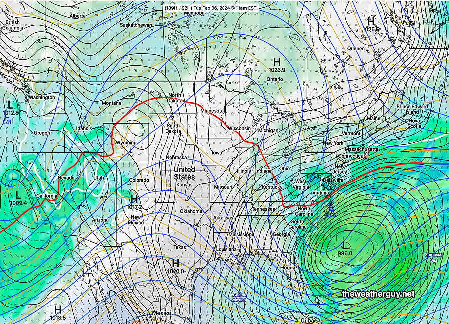
Posted Tuesday 02/06/24 @ 5:54 PM —The previous post that looked at Feb 10-12th now appears more likely the 12th through the 13th. A very similar set up is forecast for that time period, remarkably similar to that forecast back on the Jan 30th.
02-06-24 12z NAEFS shows waviness of thermal contours and potential low moving off to our south on Feb 13th. It does not look like a snow storm, but a wintry mix of rain, sleet and snow for our area is possible during this period.
There is not any jet flow amplification and it does not look like any sort of snow storm, but a light wintry mix of rain, sleet and potentially some snow for our area during this period. For the week of February 10th, a colder more winter-like pattern is likely.
Increasing Storminess beginning February 10 -12th
Posted Tuesday 01/30/24 @ 3:16 PM — Following a warm up possibly after Feb 8th, there is a signal for a stalled front to our south beginning Feb 10th. Waviness in the thickness lines suggests the possibility of several mixed precipitation events in our area, not necessarily snow. Sleet, ice, rain more likely or a mix.
01-30-24 12z NAEFS statistical “mode” version model combined with GEFS “bias-corrected” precipitation model forecast for Sunday Feb 11th. (Click on image for a larger view.)
Non-Optimum Jet Pattern for Snow Here Feb 5th-7th
Posted Monday 01/29/24 @ 4:30 PM — The jet stream pattern is trending towards warmer conditions in most of the central US, with somewhat colder. near seasonal average conditions in our area.
The main jet flow will keep any storms, both in the northern jet and southern jet, to our south. (The position of this upper trough is looking a lot like last year’s persistent eastern trough, in the ‘wrong’ position for snow in our area.)
There is a chance (low) for snow here in the time frame Monday Feb 5th through Wednesday Feb 7th. It will likely be too warm with the storm track moving the potential storm away. I don’t see any other possibilities right now in the first 10 days of February.
NAEFS forecast for Tuesday Feb 6th. Not an ideal set up for snow here. (Click on image for a larger view.)
Snow? Thur, Fri: Jan 18-19th
Posted Tuesday 01/16/24 @ 10:11 PM — I’ve moved the discussion of Friday’s storm to the main forecast blog page.
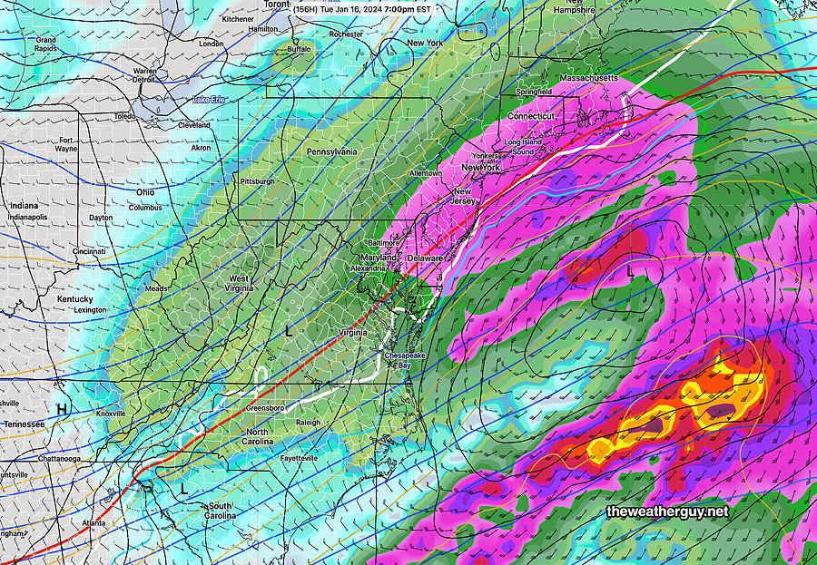
Posted Tuesday 01/16/24 @ 4:15 PM — Today’s ECMWF showed the possibility of a larger snowfall, greater than 4 inches for Friday.
It’s still only possibility; other models, except for the German ICON model, were not on-board with this forecast.
01-16-24 12z ECMWF forecast Friday 1PM (Click on image for a larger view.)
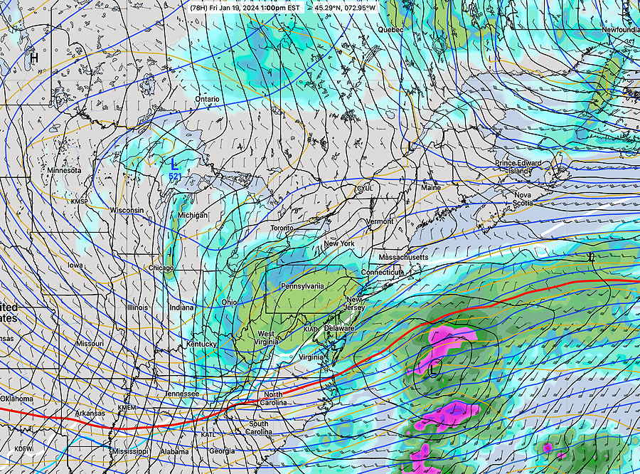
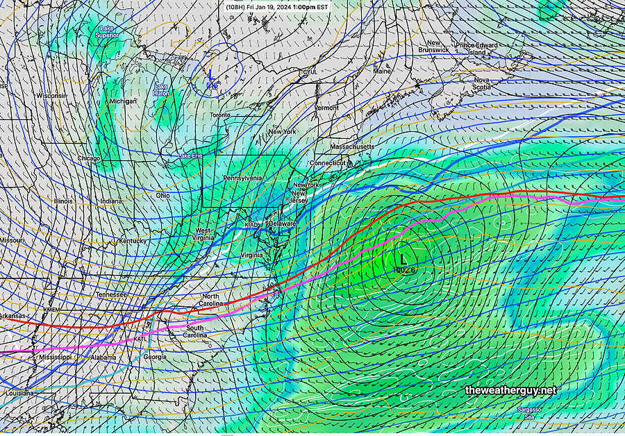
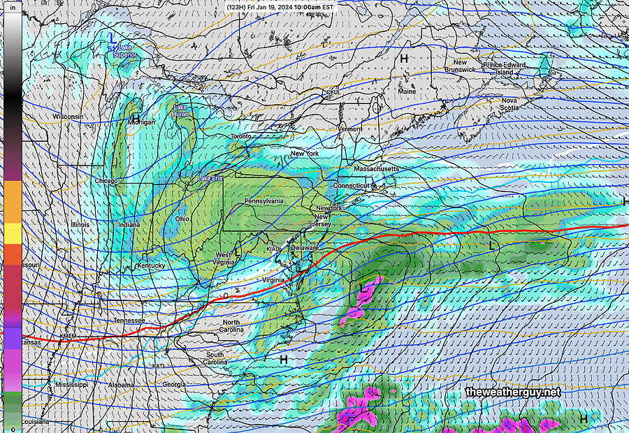
Light Snow only Jan 18-19th.
Posted Tuesday 01/16/24 @ 9:41 AM — The potential storm for Friday Jan 19th looks to have an eastward track into the Atlantic. Most models have only a light snowfall for us, about 1 inch. Deep winter cold expected through this weekend.
January thaw -Jan 24th
January thaw expected around Wednesday through Friday Jan 24- 26th. Possibly rainy conditions around the same time frame.
More on the Friday, January 19th Snow
Posted Monday 01/15/24 @ 11:33 AM — There’s more models joining the forecast for light snow this Friday, the 19th. Currently, it looks like a 1-3 inch snowfall, but it’s way too early to assume anything about snow totals yet.
Here’s the latest NAEFS forecast for Friday —
Combined 01-15-24 06z NAEFS (mode version) forecast with Bias-Corrected GEFS model 6 hour precip for Friday night 1 AM. This model doesn’t explicitly forecast snow, but based on the thermal profile, it looks to be all snow. (Click on image for a larger view.)
If the current cold winter weather is getting you down, there are strong signals that next week (Tuesday onward) will warm up considerably. But possibly wet.
Possible Snow Storm Friday January 19th
Posted Sunday 01/14/24 @ 4:03 PM —As mentioned last week, the period of Friday January 19th looks to be possibly stormy. The influx of cold air and the dip in the jet stream, along with an active southern jet stream flow may combine to create a coastal storm.
Today’s ECMWF shows the potential for a snow storm late Thursday into Friday. Too early to be sure.
01-14-24 12z ECMWF Forecast for Friday at 10 AM (Click on image for a larger view.)
I’ll be looking over the ensemble models and posting more later.
Possible Snow late Tuesday Jan 16th
Posted Thursday 01/11/24 @ 9:21 PM — A review of the latest GFS shows an increasingly likely significant snowfall Tuesday with several inches, at least, and no mixing with rain. I’ll be moving this to the main blog page Friday if the trend continues.
Posted Thursday 01/11/24 @ 8:30 PM — Another look at this afternoon’s models. The ICON and NAEFS are still forecasting snow for us. Not to be taken as a forecast, but the ICON shows 2-4 inches of snow.
Posted Thursday 01/11/24 @ 5:42 PM — Here’s why I keep these discussions on a separate page. The ECMWF has the storm missing us to our south. The NAEFS still has some snow for us. A low confidence situation.
Posted Thursday 01/11/24 @ 9:25 AM — An increasing signal for possible accumulating snow (1-2 inches, maybe more) late Tuesday.
NAEFS statistical “mode” version model combined with GEFS “bias-corrected” precipitation model forecast for Tuesday at 7 PM. While the NAEFS does not explicitly calculate snow, all levels of the atmosphere are cold enough to support (Click on image for a larger view.)
Posted Wednesday 01/10/24 @ 7:37 PM —
I’ve been looking over this afternoon’s extended models and it appears that the GFS and ECMWF are forecasting a chance of snow here Tuesday afternoon and evening as a coastal low moves to our south and east. The ECMWF is forecasting a more substantial snowfall possibility, the GFS not so much. The GEFS even less so.
Here’s the ECMWF forecast—
ECMWF model forecast
Still too far out in the future to hang your hat on this forecast. I’ll keep an eye on it.
Possible Storminess around Thursday 1/19 thru Saturday 1/21
Posted Wednesday 01/10/24 @ 7:40 PM —
A possibility of snowfall in our area for Winter ’23- ’24 is showing weakly in the time frame Thursday 1/19 through Saturday 1/21. The models are barely showing anything but a signal of waviness in the vicinity of a boundary of cold air in the southeastern US. It’s just a possibility to watch at this point.
01-10-24 12z NAEFS forecast for Friday Jan 19th.
Update on Storm- Saturday into Sunday
Posted Wednesday 01/03 @ 8:57 AM — Latest updates for this storm are now on my main forecast page.
Update on Storm- Saturday into Sunday
Posted Tuesday 01/02 @ 8:34 PM — After looking over the afternoon models (18z), the trend is as follows—
• An earlier start- light snow as early as Saturday afternoon, with flurries possible in the morning.
• A pronounced trend towards a warmer storm. From just west of the city into NJ, a mix and changeover to rain sometime during Saturday evening, limiting snow totals.
Here’s the latest higher resolution GEFS model forecast—
18z 01-02-24 GEFS 0.25º model Total snow depth at 1 AM Sunday morning. (no additional accumulation due to a mix to rain.) (Click on image for a larger view.)
I want to emphasize…this is still not a forecast. This page just shows how the sausage is made.
I’ll update mid- morning Wednesday, and I’ll be moving this to the main page later tomorrow.
BTW, the models are showing a possibly significant RAIN storm next Tuesday. Any snow will be washed away around here.
Update on Storm- Saturday into Sunday
I’ll be moving this discussion to the main blog page when the forecast period falls into the range of the higher resolutions models (84 hours or less).
Posted Tuesday 01/02 @ 5:51 PM — There’s a good reason I’m keeping this discussion separate from my forecasts.. the models continue to change and I think they’ve started to move towards something more likely than the extreme snowfall shown in my morning post.
The general trend today is for there to be less cold air brought into the system than previously forecast. The lower levels of the atmosphere now appear to be above freezing, limiting accumulating snowfall.
Here’s the latest ECMWF showing temperatures at critical levels of the atmosphere to be above freezing—
01-02-24 12z ECMWF forecast precip and critical level temperatures for Sunday morning at 1 AM. (Click on image for a larger view.)
The forecast period is still in the 110 hour range. We need to wait until tomorrow to see what some of the higher resolution models are forecasting.
The current trends:
• Precipitation begins as light snow late afternoon Saturday.
• Temperatures from the city and southeastward are looking too warm for much accumulating snow.
The latest NBM snow depths are less than posted earlier (below) but I think ranging too high. I’m not going to post them at this time.
Keeping an eye on Saturday Jan 6th – Sunday Jan 7th
I’ll be moving this discussion to the main blog page when the forecast period falls into the range of the higher resolutions models (84 hours or less).
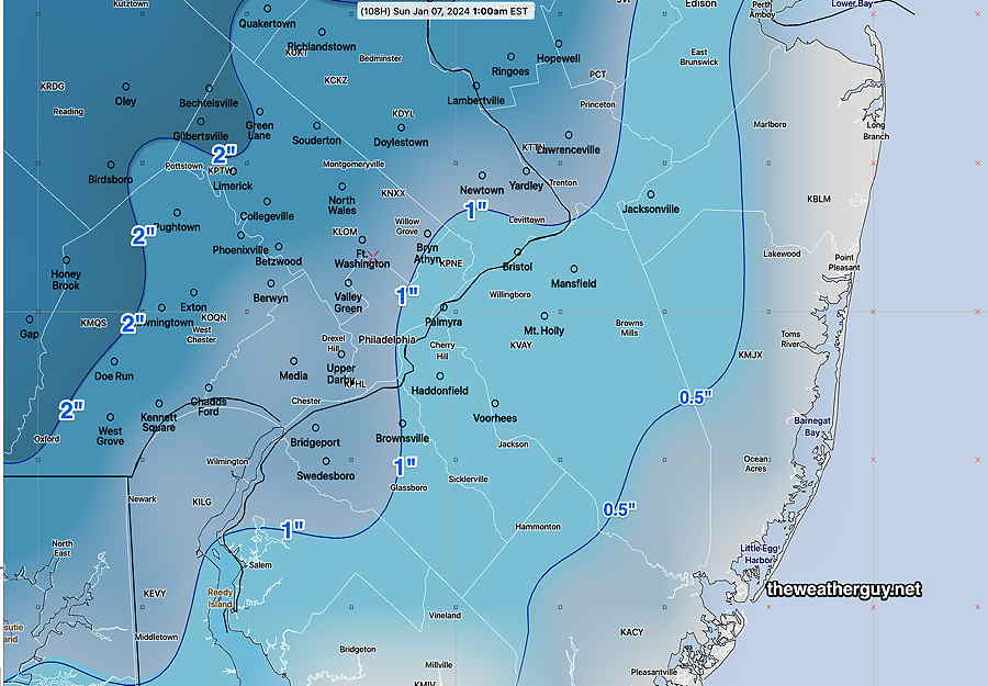
Posted Tuesday 01/02 @ 9:49 AM — So what amount of snowfall are the models predicting 120 hours+ into the future? Here’s the latest NBM (which tends to be conservative).
01-02-24 06z NBM accumulated snowfall Saturday through Sunday. (Click on image for a larger view.)
Don’t hang your hat on these numbers. Way too early!
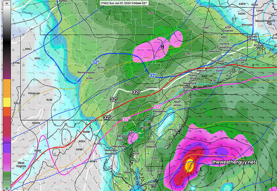
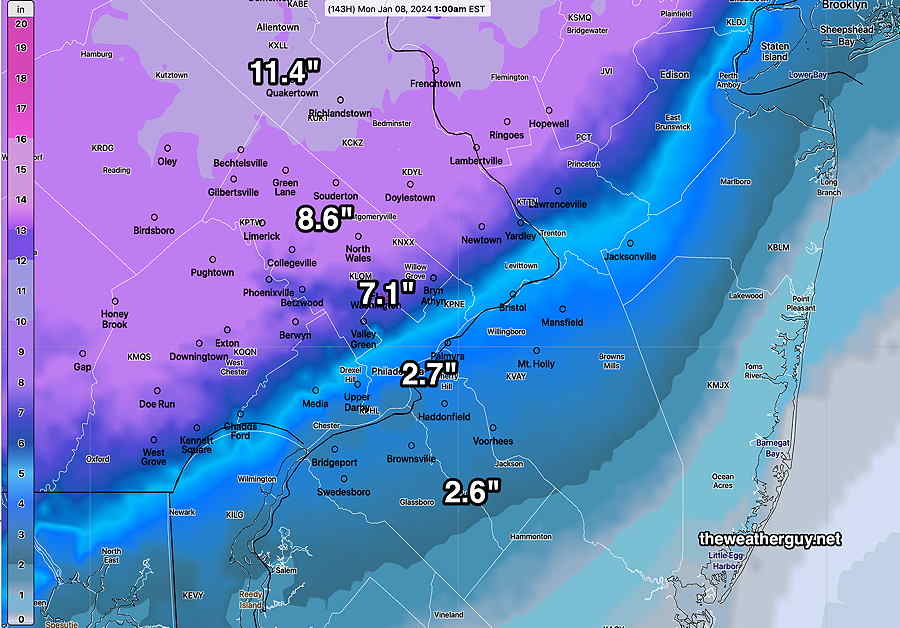
Posted Tuesday 01/02 @ 9:12 AM — Last night’s models continue with the increasing signal for a snow event here, especially north and west of the I-95 corridor (includes Philadelphia) Saturday into Sunday. It was the NAEFS model forecast that caught my eye on almost 10 days ago and I’ll continue to rely heavily on it right now. Here’s the latest forecast, just available—
01-02-24 06z NAEFS – “mode”, not “mean”, version with something called the “bias-corrected” GEFS precipitation overlay. Forecast is for Sunday 1AM. Note the various 32º isotherms, freezing at critical levels of the atmosphere, are all south of the I-95 corridor, meaning all snow to the north of those lines. That includes the red “540 thickness line”, also indicating cold air aloft. The white contour line is 32º at the surface. (Click on image for a larger view.)
Here’s the trends—
-Storm is somewhat faster, beginning Saturday afternoon. It may begin as a mix, but change to snow during the late afternoon into evening.
-Storm is trending colder.
Check back later this afternoon for an update.
Keeping an eye on Saturday Jan 6th – Sunday Jan 7th
Posted Monday 01/01 @ 7:11 PM — Back on 12/23, I posted that a change in the pattern was developing for the first week in January.
The models are trending towards a significant storm for Saturday night through early Sunday. Snow or rain or a mix.
I’m keeping this discussion on this new Winter Outlook page, because it’s still in the speculation mode, not in the forecast realm. If the model guidance continues to show consistency by Thursday, I’ll be moving this discussion to the main weatherguy page.
The storm is about 130 hours out, well outside the range of the higher resolution models (which typically forecast out to 48-60 hours and 84 hours).
Speaking of consistency, today’s NBM, GFS and GEFS/NAEFS are showing snowfall for our area. On the main page, I wouldn’t be posting snow totals this early in the game, but I’m sure you’re curious of what’s being forecast right now—
01-01-24 18z GEFS snow totals The inch labels refer to the line contour. Any location on the contour is the same. Half way between contours will be halfway between amounts of the same contour. (Click on image for a larger view.)
Whatever this one model shows, it’s gonna be different in the next model run. That said, I haven’t had the opportunity to use my snow graphics in a long time! Stay tuned.
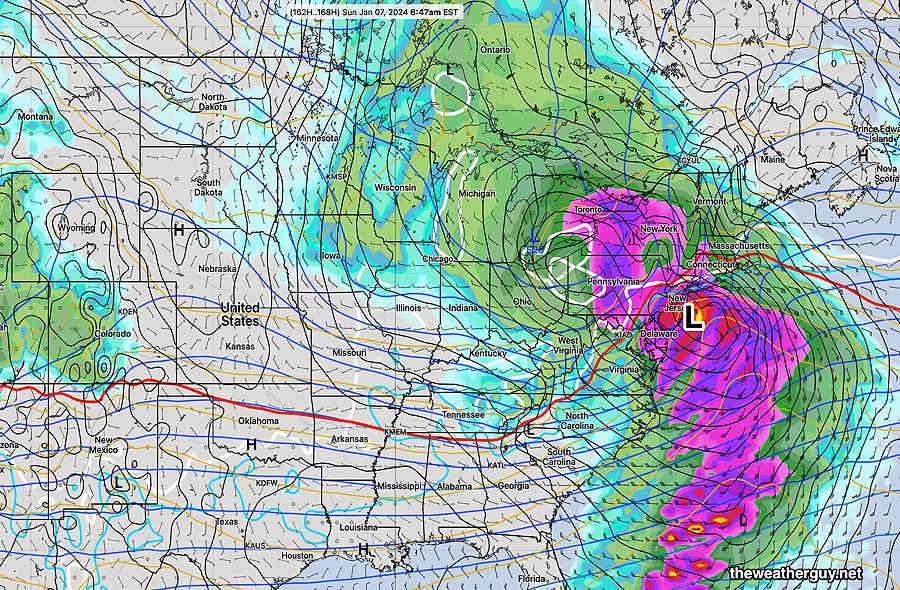
Keeping an eye on Sunday Jan 7th
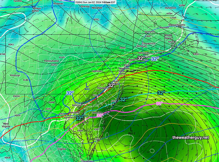
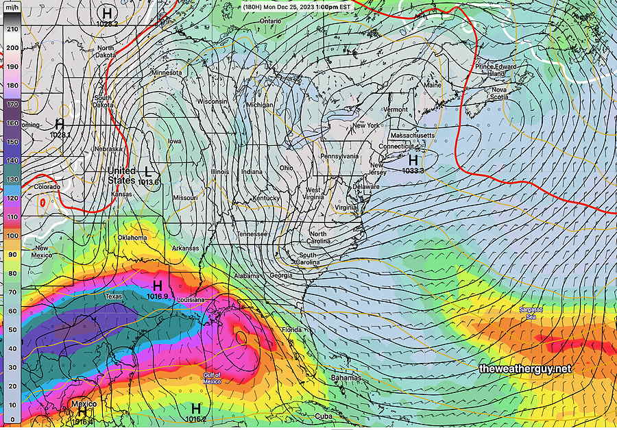
Posted Monday 01/01 @ 2:10 PM — Our snow-less streak may be coming to an end. The GEFS has been consistently forecasting a coastal low for late Saturday into Sunday. As you can see below, much of Philadelphia will be above freezing (white line is the freezing line), but some accumulating snow (not much) is possible for the northern and western suburbs.
I should add that the ECMWF is has a more potent and colder system.
01-01-24 12z GEFS shows a coastal low. Critical snow temperatures (red, violet and blue) will be south of our area, indicating snow likely, but the freezing line at the surface (white line) is just north of Philadelphia.
Posted Sunday 12/31 @ 4:20 PM — A change in the overall weather pattern is expected towards the the first weekend in January. It will be somewhat colder. A broad upper trough will develop with southern jet stream systems moving to our south with some coastal development possible. First one is Thursday.
Most interesting is the system forecast by the ECMWF for next Sunday, Jan 7th—
12-31-23 12z ECMWF forecast for Sunday Jan 7th. An “interesting” scenario. Critical temperature lines are too far west for snow here, at least with this forecast. (Click on image for a larger view.)
Right now, too warm for snow for us, but things could change.
Outlook- First two weeks in January
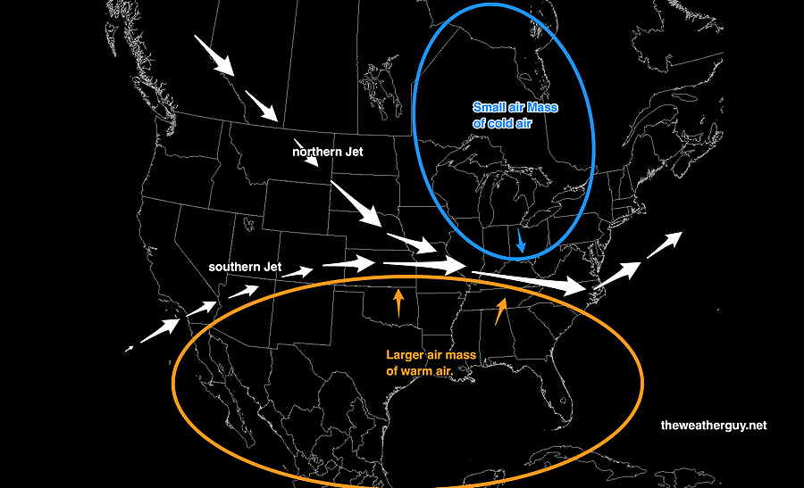
Posted Saturday 12/30 @ 10:34 AM — For the past few weeks, the pattern looked like it was going to shift to a colder, typical winter pattern. The latest trends support a somewhat colder pattern, but not cold enough for snow here.
The theme of this winter continues— “not enough cold air”. This may sound simplistic, but it’s also true.
Temperatures in northern Canada, while cold, aren’t close to typical numbers. (no -35º, no -40º) To get snow here, we need a sharp trough with very cold air and high pressure to our north.
Simplistically, it could be shown as such—
A much larger dome of warm air and a smaller dome of colder air. The warm air is winning out. As is always the case, the jet stream flows in the valley between the air mass domes. While the jet stream affects its own position in a dynamic feedback fashion, the main determinant of the jet flow position is the three dimensional position/size of the air masses and the location of the “valley” between them. In most winters, the cold air dome builds up density as it chills down and moves down . Not enough cold/ density for it to do that so far. (Click on image for a larger view.)
Changing Pattern after Dec 31st
Posted Thursday 12/28 @ 10:23 AM — I’m keeping my eye on the weekend of Saturday Jan 6th to start—
NAEFS for Saturday night Jan 6th. Mixed precip- snow far northwest? (Click on image for a larger view.)
Posted Wednesday 12/27 @ 9:05 AM — There continues to be a strong signal for a weather pattern change around January 4th or 5th, 2024.
A colder pattern with a broad upper trough active and wavy frontal boundary in the Southeastern US; Gulf moisture streaming north.
Missing ingredient for snow is a sharp upper trough.
NAEFS forecast for Saturday Jan 6th
Changing Pattern after Dec 31st
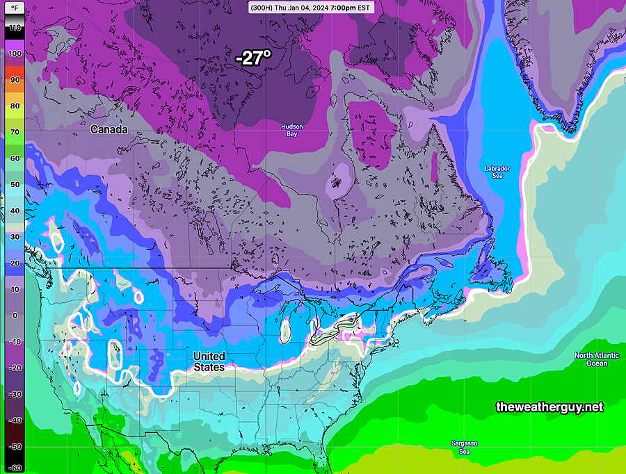
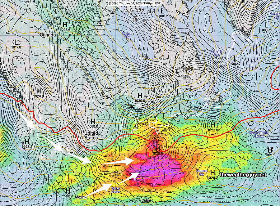
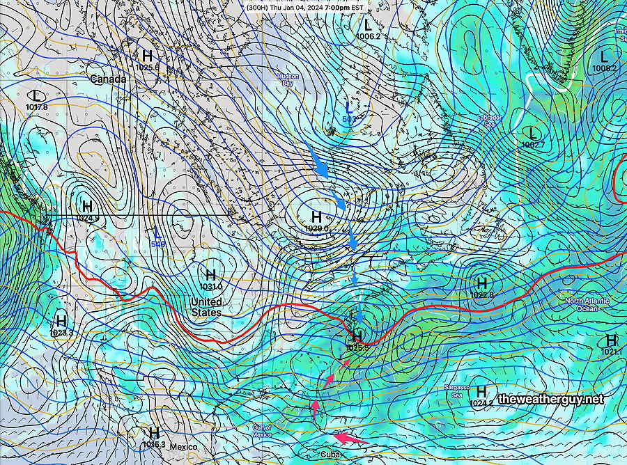
Posted Saturday 12/23 @ 4:58 PM — A distinct change in our mild weather pattern looks to be setting up for the first week in January. One, might say, duh…. hey, it’s January, it’s supposed to be getting colder. And to a large extent you would be right.
Nonetheless three factors are coming together for a more typical winter weather pattern and possibly some winter snow.
(The maps below are all from the NAEFS forecast for January 4th.)
A sudden buildup of very cold air in Canada—
NAEFS : As cold as -27º F is, it’s not the deep cold level (-40º) that can develop. Nonetheless, it’s a move in the right direction. (Click on image for a larger view.)
2- A dip in the jet northern stream and an active southern jet stream that appears to phase —
NAEFS: Active southern jet flow and broad trough (dip) northern flow. (Click on image for a larger view.)
3- High pressure descending southward and moisture from the Gulf of Mexico with wavy boundary—
NAEFS: Active stream of moisture up from the Gulf of Mexico with cold air descending from large high pressure to the north. (Click on image for a larger view.)
The models are currently NOT showing any coastal snow storm for the period, but the necessary ingredients are presenting themselves for the first time this winter. The devil is in the details, that only clarifies a few days beforehand.
Keep in mind, this page doesn’t do specific forecasts. It simply presents the trends and patterns that are emerging for this winter in the coming weeks.
Through Dec 30th- No snow expected
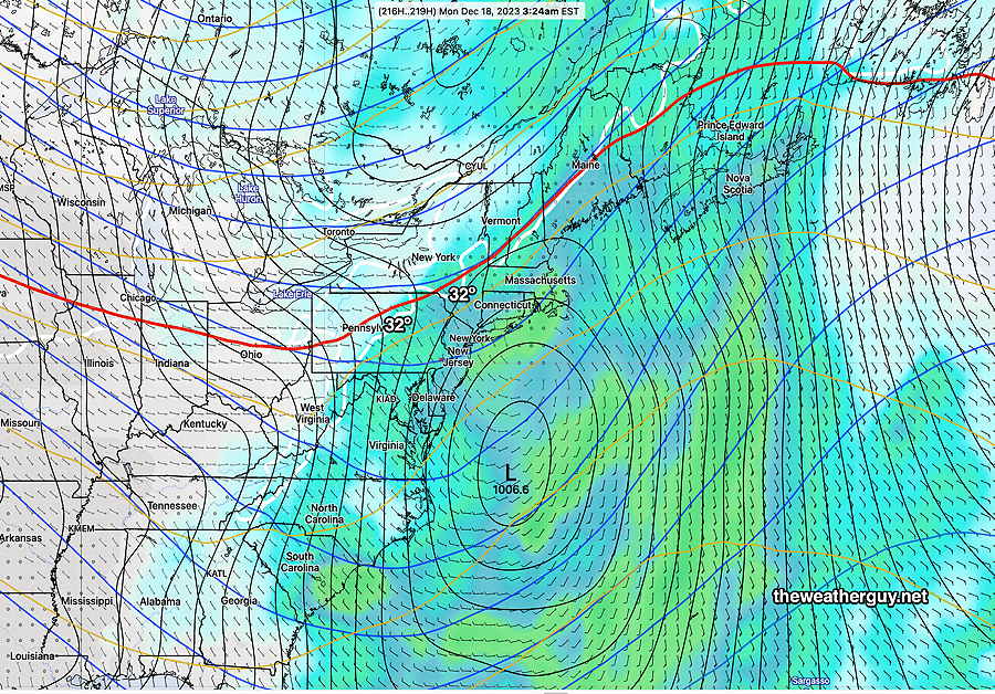
Posted Monday 12/18 @ 10:45 AM — There continues to be a pattern of very little truly cold air descending into the country’s northern tier with a resulting northern stream jet configuration that is ridge-like to flat. An active southern jet stream continues to bring rainy conditions to Florida and the Southeast. Impulses arriving here will not encounter enough cold air for snow.
For Christmas weekend (Dec 25th shown below) , quiet conditions while we are under an upper ridge—
NAEFS jet stream winds, surface pressure and 540 thickness along with 32º surface freezing line (white) (Click on image for a larger view.)
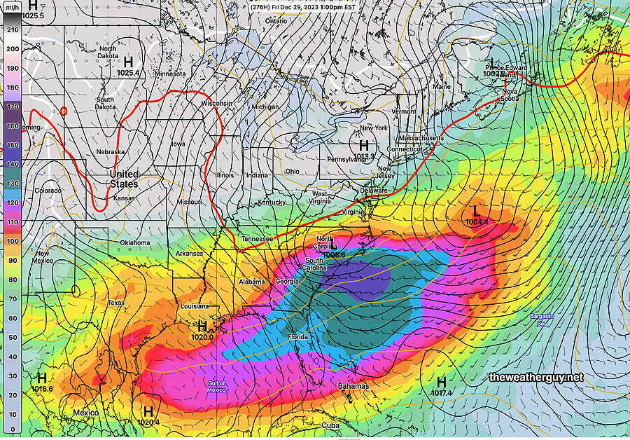
Through the following week (Dec 29th below) , a change towards a slight upper trough. Perhaps some activity but the amount of cold air at the surface seems to be lacking for snow despite the dip in the jet—
NAEFS jet stream winds, surface pressure and 540 thickness along with 32º surface freezing line (white) (Click on image for a larger view.)
Through Dec 18th- No snow expected
Posted Saturday 12/09 @ 9:55 AM — Based on my Google traffic stats, this Winter Outlook Discussion seems to get a lot of interest, so I plan to keep it updated with the latest outlook (not forecast). The GEFS, whose forecasts extend out 384 hours (15.5 days), has the next possible winter storm for us Dec 18th, but alas, it’s looks to be too warm for snow. This may be a recurring theme this winter:
GEFS forecast for Monday, Dec 18. Too warm for snow, despite a coastal system. White line is 32º line. (Click on image for a larger view.)
Keep in mind, this page has outlooks that will likely just be based on the extended range GEFS, NAEFS and ECMWF. Any outlook greater than 5 days out is at best an educated guess. And I’m quite certain that any two models in the extended range will have very different forecasts.
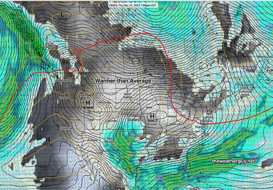
Posted Thursday 12/07 @ 7:54 PM — I’ve been looking ahead into the middle of December. I don’t see any sign of pattern that will support the development of a major snowstorm in our area. There will be the development of an anomalous ridge in the west and a persistent high pressure system in the southeast. The dip in the jet is similar to last year’s snowless winter.
18z GEFS 12-07-23 shows a large expanse of warm air in the west and large high pressure. The red 540 thickness line is well into Canada, instead of dipping down into the US. (Click on image for a larger view.)
No snowstorm in the 10 day horizon.
Posted Wed November 29,2023—
Winter Outlook Discussion—I often get asked about the coming winter weather outlook, especially about the potential for large snow storms.
Disclaimer: Climate forecasting and weather forecasting, while related, are very different animals. While I know I’m pretty good with weather forecasting, my climate forecasting remains in the realm of an educated soothsayer.
One thing is clear. The current pattern is very different than last year. I described the difference in jet stream position in the immediately preceding previous post of Nov 12th.
I am seeing some things lately that suggest a stormy winter, specifically the tendency to have frequent coastal secondary low pressure development with a sharply dipping jet stream in a somewhat favorable position. The million dollar question will be the amount of cold air that can be available for a snowstorm here in Philadelphia. Even in colder years, before the current climate changes, Philadelphia was often on the border of the rain-snow line.
With climate change, that rain snow line will most likely be even slightly further north and west of our area.
I do see large swings in temperatures likely as well for the winter. Our January thaw could have a week of 60s and even 70s at some point.
But with all that coastal storm development lately, a few good snowstorms this season look to be a better possibility than last year.
Yet I wouldn’t be surprised if the majority of our storms become mixed precipitation type events with rain changing to snow or snow to sleet/rain in Philadelphia and the immediate suburbs.
I know I’m hedging here. It just takes one big storm to kill a winter climate outlook.
Posted November 12, 2023
Winter Outlook Discussion —Which brings me to the winter forecast. Frankly, I think we’re going to see large swings in temperatures here with primarily mixed precipitation events here. Not necessarily large accumulation snow storms.
The jet pattern these past several months has been somewhat different than last year. With almost no accumulating snow last year, it’s unlikely to be similar, but it doesn’t mean we’re “due” for big snow storms.
Last winter, a persistent dip in the jet had the main axis of the trough directly over us, causing storm formation to occur in the Atlantic. This year, I ‘m seeing more favorable positioning of the axis of the jet dips (more to our west), but favoring warm air preceding any storm. The major storm developments over recent months have all been to our north and east, missing us. Will that continue?
Patterns change; what we have now could be different in January. But the trend towards warmer temperatures may be an increasingly large factor when it comes to getting large snow storms here.
2 thoughts on “Winter ’23-’24 Outlook Discussion”
Will 5 or so inch snowstorms become every 3 or 4 year surprises? Are we now Raleigh or Atlanta?
An interesting thought and comparison. I don’t think we know the answer to that question just yet. And too soon to write off a storm here this season. Patterns can change dramatically in even 4-6 weeks. But I’m amazed at how much warm air is advecting northward and how little cold air is advecting southward.