Update Sun 1/15 4:55 PM — Monday will be sunny and milder. Still somewhat breezy.
High temperature 46.3.º sd 1.6º NBM model – for location Blue Bell, PA
Sunday
Update Sat 01/14 @ 4:34 PM — The clouds hung in today.
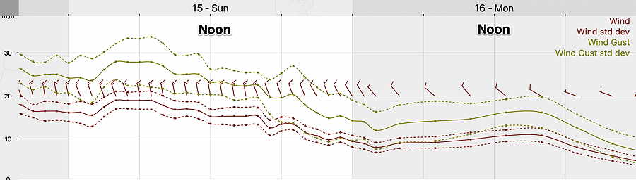
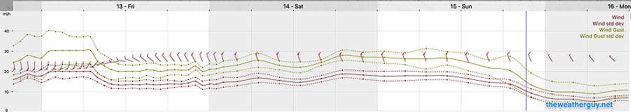
Skies clear early Sunday morning. Sunday will be sunny, continued cold and still quite windy. Here’s the latest NBM wind meteogram—
NBM wind and wind gust meteogram for location: Blue Bell PA (Click on image for a larger view.)
Update Sat 01/14 @ 10:25 AM —
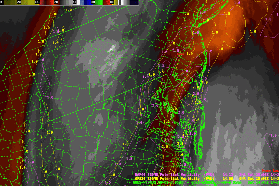
Water Vapor Image from Saturday shows moisture moving northwestward from intensifying low pressure off the Carolinas. Notice poor alignment of yellow and violet contours (“Potential Vorticity”) with darker-warmer areas of image suggests some modeling discrepancies between the GFS (yellow contours), NAM (violet contours) in our area and the actual upper air situation. Explains some of the differences in cloud cover forecasts. (Click on image for a larger view.)
Update Sat 1/14 8:08 AM — I often don’t watch the TV weather at 10 or 11 PM, but last night, I was curious how they were handling the uncertainty in the cloud cover for Saturday. Now I know how they handle it— they basically avoid the subject. I listened carefully; it just didn’t come up. On the ridiculous single weather picture summary at the end, they had the words, “some sun”. Yeah? When? How much? Where? If you weren’t really thinking about it, you didn’t realize that they didn’t tell you anything beyond it was going to be cold and windy.
So let’s jump to the chase: there’s still uncertainty and wide differences in the cloud cover forecast for today, Saturday. I’m leaning towards cloudiness until about 2-4 PM, where we may see “some sun” in some spots. I’m leaning on the new NBM version 4.1 for this forecast. (The new version 4.1 goes into operational service on Jan 17th).
Update Fri 1/13 9:18 PM — Tonight’s models, just coming in, continue to emphasize considerable cloudiness for Saturday especially from the city and eastward, and even a slight chance of scattered snow flurries.
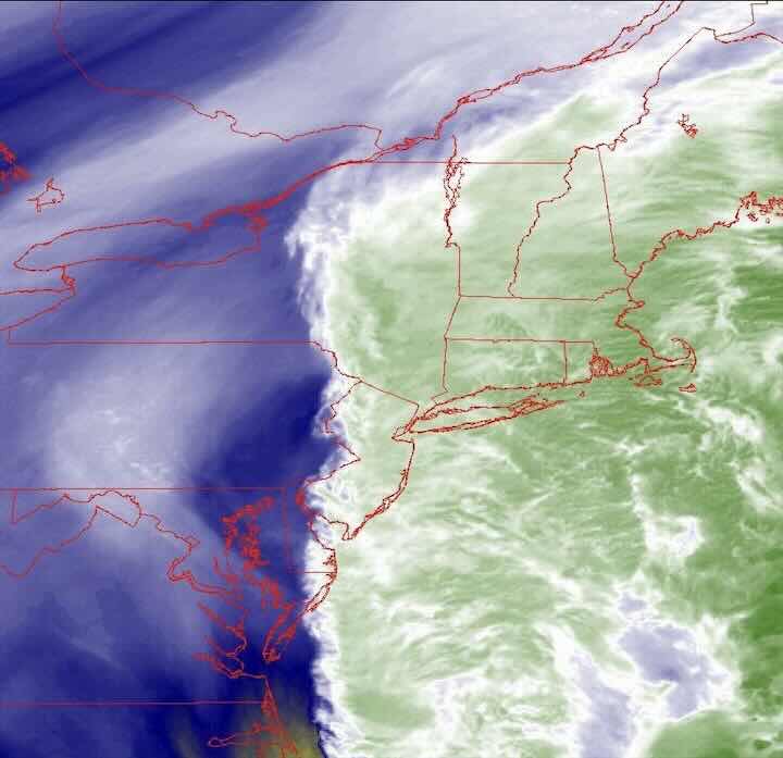
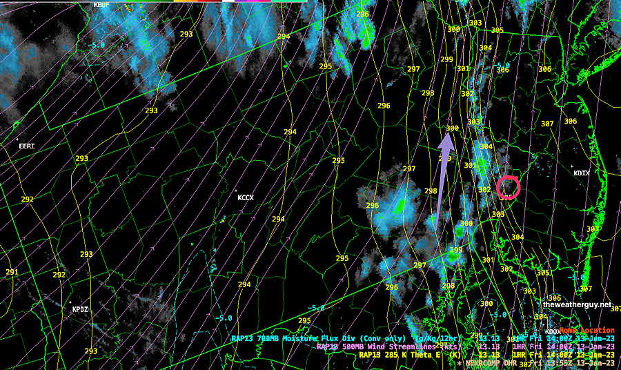
Current water vapor image correlates to the western extent of the cloud cover forecast from tonight’s NAM and HIRESW models—
NAM and HIRESW models have the current water vapor plume above as the western extent of the clouds tomorrow. Others have it further west.
Previously Posted Fri 5:46 PM —
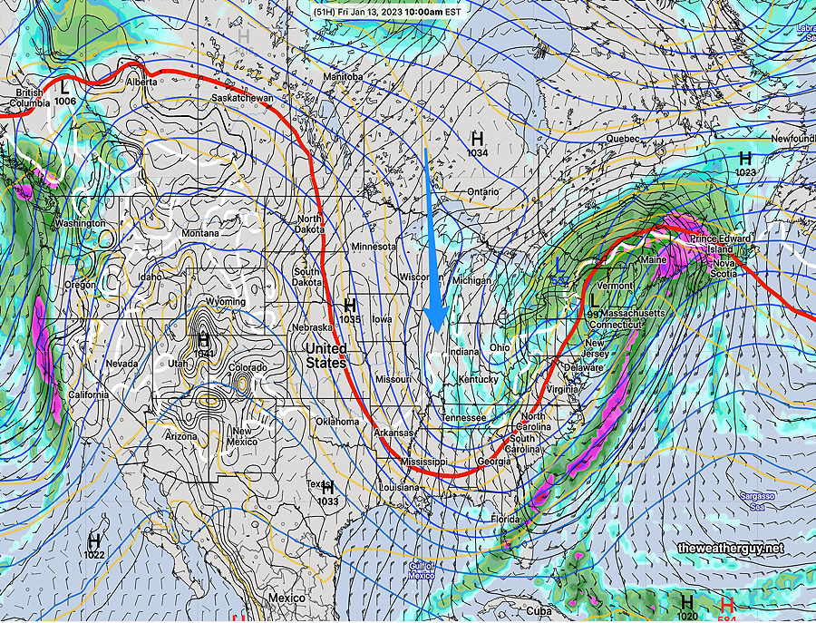
A cold front moved through on Friday, and a highly amplified jet stream trough will have us in colder weather for the weekend. The sharp trough will induce a low pressure system in the Atlantic. This system will be too far east to affect us, except for some cloudiness, especially at the Jersey shore on Saturday.
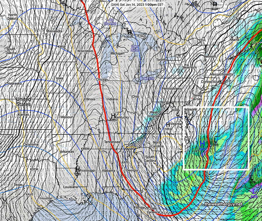
Latest GFS (18z) shows deep trough of cold air (as captured by the red 540 thickness line). Low pressure develops in the Atlantic, but too far east to affect us here except for some cloudiness. (Click on image for a larger view.)
Saturday
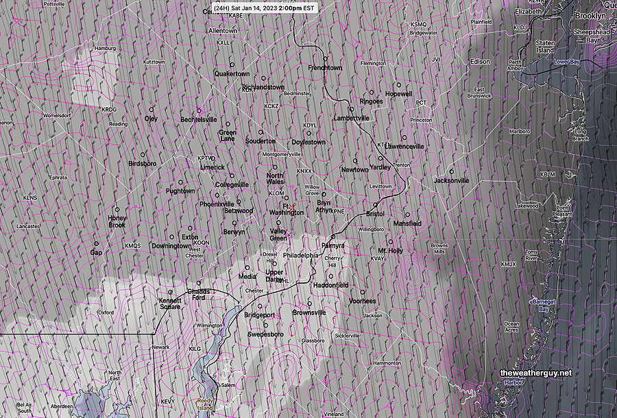
Cold air with the trough along with the coastal low will bring more cloudiness than originally expected in many areas, especially into New Jersey. It will be quite WINDY and cold. Cloudiness lifts during the afternoon hours.
NBM cloud cover forecast for 2 PM Saturday. More clouds than originally forecast. (darker is more clouds; violet contours are standard deviations) (Click on image for a larger view.)
High temperature Saturday 37.8º sd 1.7º NBM model – for location Blue Bell, PA
Sunday
Sunny, continued quite WINDY and cold.
High temperature 42.0º sd 1.5º NBM model – for location Blue Bell, PA
Monday
Sunny and milder. Still somewhat windy.
High temperature 45.2º sd 2.3º NBM model – for location Blue Bell, PA
Update Fri 01/13 @ 9:34 AM — The rain has lingered longer than I had forecast. (The latest NBM and HRRR show no showers here at this time. Go figure.) The residual showers should be tapering off and moving off shortly to our northwest by about 11:30 AM
Latest Radar with superimposed Theta-E (yellow contours) and 500 mb wind streamlines (violet) . The tight packing of the Theta-E contours just west of the city shows the position of the front. (RAP model) (Click on image for a larger view.)
Friday and the Weekend
Update Thu 01/12 @ 5:19 PM — The showers and rain have moved in with a warm front, and additional rain will precede a cold front passage early on Friday morning.
The rain ends about 7-8 AM Friday morning.
The models aren’t predicting all that much rain (0.30-0.40 inches) in our area. The big story will be the WIND which is already picking up as I write this.
Gusts 30 to possibly 40 mph towards midnight tonight and windy conditions through the weekend. Here’s the NBM wind meteogram for Blue Bell—
Latest NBM forecast wind and wind gusts for location Blue Bell PA. (Click on image for a larger view.)
Temperatures will drop from the 50s Friday morning to the mid 40s in the afternoon, but the wind chill will make it feel colder. A mix of considerable cloudiness with some sun expected on Friday,
A secondary cold front moves through Friday evening and temperatures will drop below freezing by early Saturday morning. The weekend will be sunny, cold and dry.
One more thing — considerably colder air is finally pooling in Canada and in Greenland. In another 7-10 days, we will likely see some snowstorm activity as the cold air sinks south. (Just conjecture at this time. )
Thursday Through Friday
Update Wed 01/11 @ 5:10 PM — Moisture aloft moving in from the southwest over colder air at the surface will result in light showers or drizzle early Thursday morning. The rest of the day looks to be cloudy with additional showers later in the afternoon.
Thursday night: Rain develops during the evening hours Thursday and becomes heavier around midnight. Look for WINDY conditions to develop as the evening progresses. Thursday into Friday as a warm front approaches.
Friday: The warm front moves through before daybreak and then a cold front moves through Friday morning. Skies begin to clear late morning on Friday. It will bewindy and temperatures will slowly drop. Friday will still be relatively mild.
A stronger cold front moves through early Friday evening.
Much colder for the weekend!
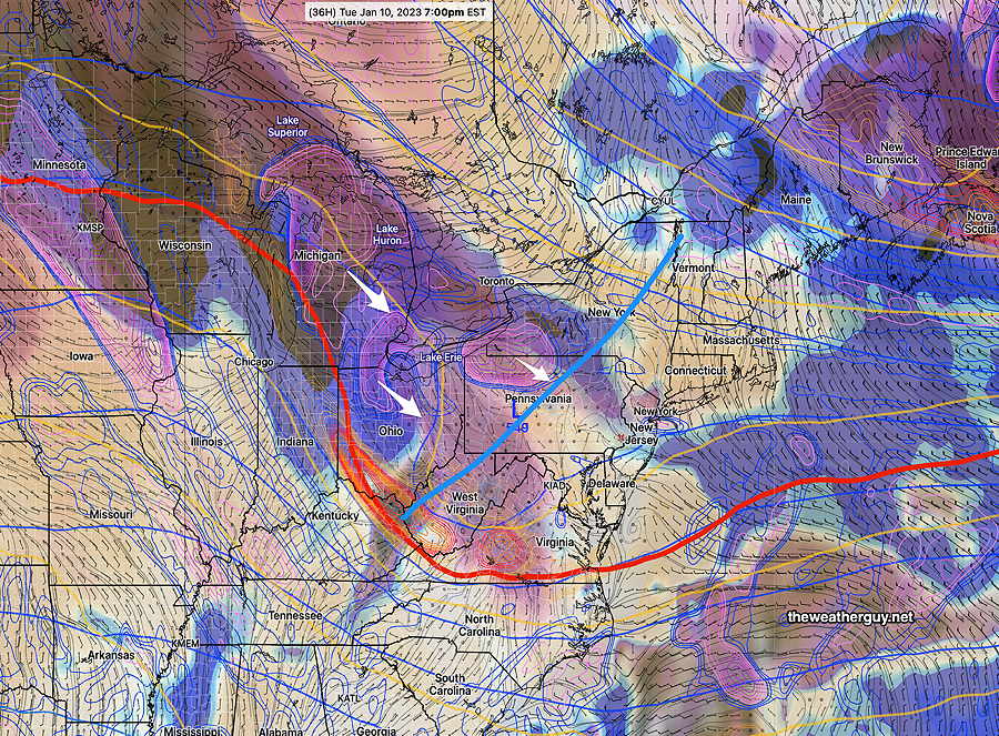
ECMWF forecast for Friday at 10 AM. Rain is ending here around that time. A sharp but progressive dip in the jet stream (as captured by the red 540 thickness line) will bring cold air on Saturday and Sunday. (Click on image for a larger view.)
Wednesday
Update Tue 01/10 @ 8:15 PM — Not much happening weather-wise, so let’s see if tomorrow’s cloud forecast does better. Thickening high cirrus clouds in the morning. Cloudiness increases about 10:30 to noon. Cloudy most of the afternoon. (Based on tonight’s 00z NBM and HRRR, just available.) Easterly winds will keep it colder to about 43º for a high.
Tue 5:36 PM Forecast Review — We had less cloudiness than any of the model forecasts had predicted. Cloud forecasts can be challenging.
Forecast Update
Update Tue 01/10 @ 9:25 AM — The cloudiness forecast below for today, Tuesday, has begun moving in. These clouds are the result of an upper air disturbance and trough moving through. High 42-44º
For Wednesday, a similar forecast with partly cloudy conditions giving way to mostly cloudy in the afternoon. High 43-45º
The storm for late Thursday into early Friday will be a rain event. Cold air arrives after the storm has departed. High ~55º
The weekend looks cold, but a moderating trend is expected next week with temperatures again above average. I don’t see any potential snowfall for us in the next week or so.
Previously Posted Mon 4:38 PM —
Overview
A benign weather pattern for us this week through early Thursday as a somewhat flat to ridge-like pattern will prevent any storms from forming.
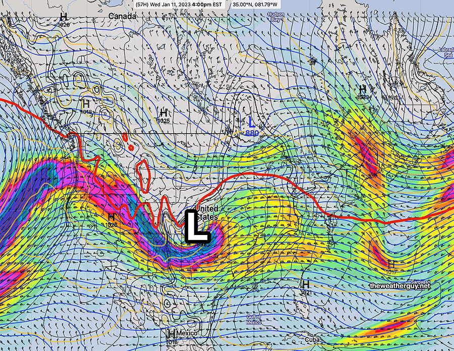
Monday’s 12z ECMWF jet stream wind forecast for Wednesday at 4PM. Low pressure (L) at the surface and aloft is the remnants of the storm that is battering California on Monday. This low will move eastward as high pressure dips down from Canada. (Click on image for a larger view.)
Temperatures warm up a bit on Wednesday and especially on Thursday with the ridge moving eastward.
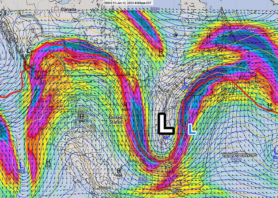
By late Thursday into Friday, a sharp upper air trough will develop and spawn a surface low off the coast—
Monday’s ECMWF jet stream wind forecast (300 mb level winds) for Friday at 4 PM Upper low (L) and deep trough will spawn a surface low (blue small L) off the coast. (Click on image for a larger view.)
Currently there isn’t much cold air that will move in before the storm departs late Friday afternoon, so all the precipitation will be rain for us late Thursday into Friday. While this could change, there hasn’t been any model suggestion of early deepening of the coastal low.
Tuesday
For Tuesday, an upper level trough with some disturbances will approach with partly cloudy skies becoming cloudy during the afternoon. No precip expected.
ECMWF 500 mb mid level contours with relative vorticity and humidity (Click on image for a larger view.)
By Wednesday, temperatures begin to moderate a bit.