WEEKEND WEATHER FORECAST

#weather #paweather #wx #pawx #philadelphia

Back where we started

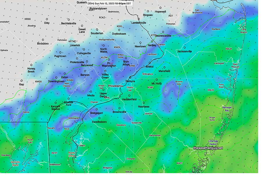
Update Sun 2/12 10:53 AM — This morning’s NAM has reverted back to the rain moving into Philadelphia. Now about 8-10 PM and continuing into the night. The Eagles win forecast hasn’t changed.


Forecast change

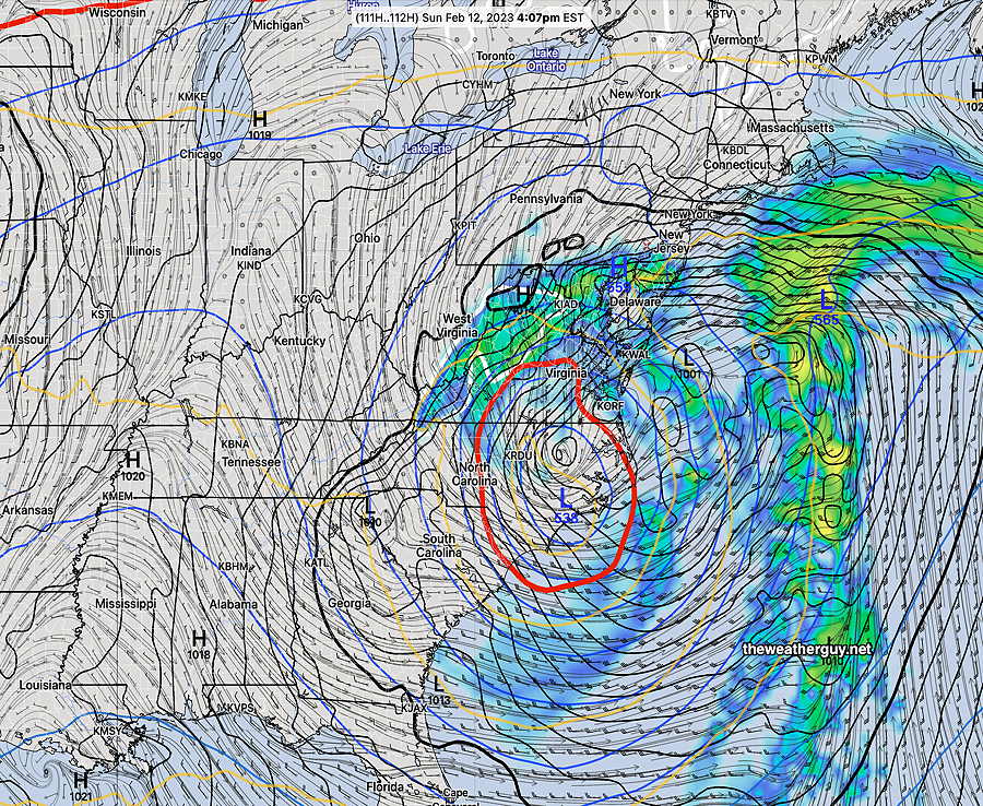
Update Sat 2/11 10:22 PM — Tonight’s high resolution models (NAM) keep the rain well south of our area Sunday evening. A significant change in the forecast.
Update Sat 2/11 11:18 PM — BTW, the GFS and tonight’s Canadian RGEM still have the rain here, as previously forecast. My bet is on the NAM and the Eagles.


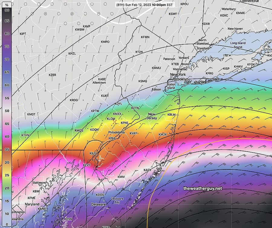
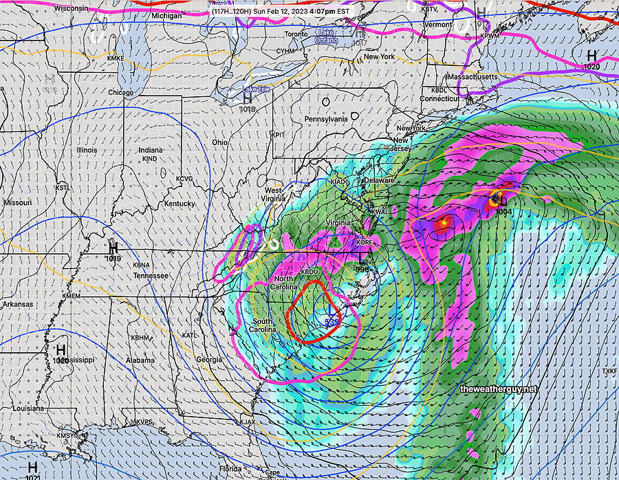
Update Sat 02/11 @ 5:56 PM — No major changes in the forecast for Sunday. Rain moves in from the south between 4-6 PM. In the city, it will be very light and there will be a sharp cutoff just north of the city’s northern immediate suburbs. This has been a boundary or edge condition for the precipitation shield for days and some models are further north, some are further south.

The HREF forecast provides a good compromise—

18 z HREF simulated radar with accumulated precip contours (light green) . Total amounts range from 0.02” to as much as 0.10” in the immediate PHL area, more south, less north. Click on image for larger view

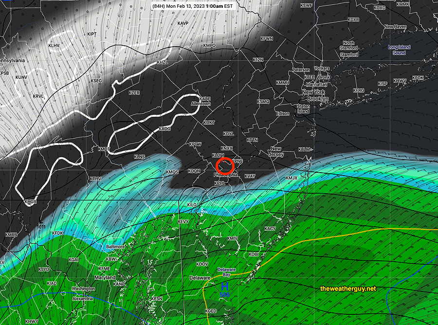
One change is the precip moves out as early as 11 PM to midnight, just in time for the Eagles victory celebration.

Still no signs of any snow here for the next 10 days!

Update Fri 2/10 10:43 PM — Tonight’s models are trending towards a bit earlier start of the rain on Sunday in Philadelphia, perhaps as early as 4-6 PM. Unfortunately, it appears that it might advance further north with somewhat heavier rain making it into the city than previously forecast. Stay tuned.


A secondary cold front will pass through Friday night and Saturday will be much colder than previous days.

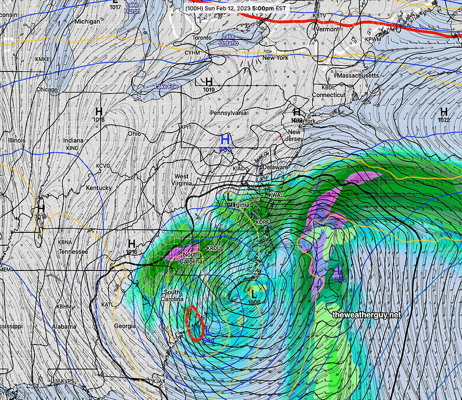
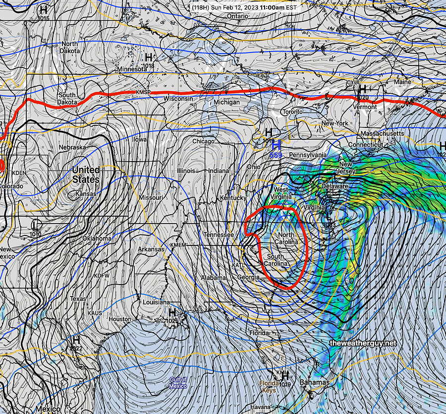
A coastal storm with a closed low will be blocked from moving north. The precipitation shield will affect NJ and Delaware during the day Sunday. Light showers will move in to the immediate Philadelphia area Sunday about 5-7 PM

Saturday

High pressure will bring mostly sunny skies. Windy conditions in the morning will gradually subside during the afternoon. Some clouds towards sunset.

High temperature 45.1º sd 1.5º ( NBM model- location Blue Bell, PA)

Sunday

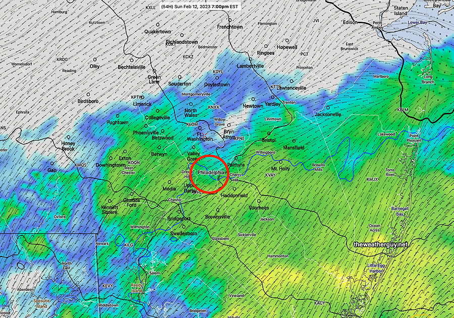
The coastal low will move north but be blocked by high pressure. While the rain will be significant in South Jersey and Delaware, only light rain is expected to move into Philadelphia early evening.

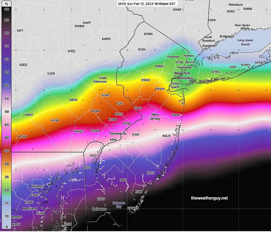
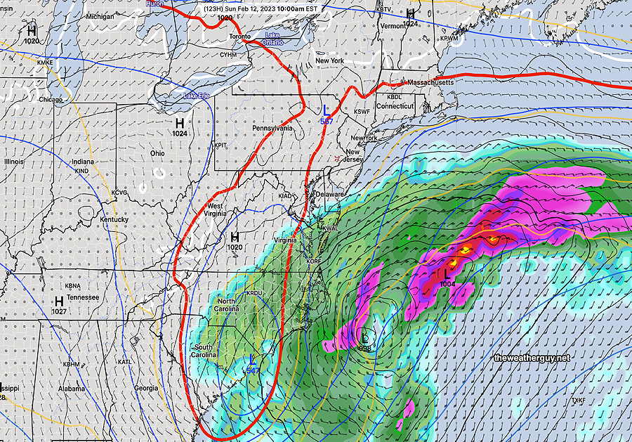
Here’s the northern-most extent of the rain by 7 PM, according to the high resolution NAM-NEST

Today’s 18z NAM-NEST simulated radar forecast for 7 PM Sunday. The NAM-NEST forecast is very similar to several other models, perhaps just a bit further north with the rain than several.

High temperature 45.6º sd 2.5º ( NBM model – location Blue Bell, PA)


WEEKEND WEATHER OUTLOOK

#weather #paweather #wx #pawx #philadelphia

Update Fri 2/10 4:35 PM — A quick mobile update. The precipitation on Sunday does now appear to move into Philadephia between 6-8PM. It doesn’t appear to move much further north than the immediate suburbs. The regular Weekend Weather Forecast will be posted later.

Still Some Uncertainty

Update Thu 02/09 @ 8:04 PM — So while the NAM, GFS and ECMWF posted below keep the rain to our south until midnight or after, the statistical models are not all that sure.

Here’s the NAEFS that just became available. The NAEFS combines the Canadian ensemble model with our GFS ensemble (GEFS).

Here’s its forecast probability of light rain before 10 PM Sunday —

Today’s 18z NAEFS shows a 30% chance of rainfall greater or equal to 0.10 inches by 10 PM for the preceding six hours. (Click on image for a larger view.)

If we set the threshold for any rain lower, as little as 0.01 inches for the six hours preceding 10 PM Sunday, here’s the probability—

Today’s 18z NAEFS probability of greater or equal to 0.01 inches of rain before 10 PM Sunday. It’s 45% in Center City and for a six hour period, that’s relatively high for a six hour period.

This NAEFS is more in line with the latest Canadian regional GEM, the latest German ICON model and the SREF.

So it’s going to be a close call. Some sprinkles and light rain possible here during the Super Bowl, but not a sure bet. My regular readers know my mantra, “never ignore the NAM” which currently keeps us dry.


I’m still keeping an eye on the weather for Sunday and based on today’s ECMWF along with the latest GFS , it appears that the rain will stay south of Philadelphia until after midnight Sunday. Indeed, currently there’s remarkably good agreement in the models today, considering how far apart their forecasts were just a few days ago.

Here’s the latest GFS, just available—

Today’s 18z GFS forecast for Sunday night (actually midnight Monday). The rain stays to our south at that time (Click on image for a larger view.)

The forecast period in question now falls within the forecast horizon of the latest 18z NAM model (84 hours). The NAM forecast is remarkably similar to the GFS —

Today’s 18z NAM forecast for 1 AM Monday morning (Click on image for a larger view.)

Even today’s ICON model (posted earlier today) has fallen in line with the other models.

So things look good weather-wise for the Eagles victory celebration.


THIS WEEK’S WEATHER

#weather #paweather #wx #pawx #philadelphia

Continuing Forecast Change For Sunday

Update Thu 02/09 @ 8:57 AM — Regarding the coastal storm that is now forecast by all models to develop Sunday, the latest GFS keeps any significant rain out of the immediate PHL area until after midnight Sunday into Monday morning. A few other models have light rain moving in after 6 PM–

06z German ICON model forecast for 7 PM Sunday night (Click on image for a larger view.)

Continuing Forecast Change

Update Wed 02/08 @ 6:21 PM — Today’s models have moved away from having the coastal storm progress northward very much on Sunday and will likely skirt to our south later Sunday night into Monday.

Here’s the latest GFS—

Today’s 18z GFS forecast for 5 PM Sunday. (Click on image for a larger view.)

Interesting Weather Possible Sunday

Update Wed 02/08 @ 8:39 AM — The complexity of the weather setup for this weekend has been a challenge for the numerical weather models, and over the past week or so, I’ve been watching this scenario evolve.

The GFS forecast for this weekend over past days has been described as an ‘outlier’ by the NWS chief forecasters, but interestingly, last night the ECMWF joined the ‘outlier’ GFS in forecasting a closed low and a coastal storm for Sunday!

In a “normal” winter, this might pose the potential for major coastal snowstorm, but this winter and this weekend, the thermal profiles are quite complex. As a result, the precipitation type will be a difficult forecast, but it is still leaning heavily towards rain here.

The current forecast track may keep it from moving further north than shown below at 4 PM Sunday—

ECMWF forcast for Sunday 4 PM (Click on image for a larger view.)

GFS—

GFS forecast for 4 PM Sunday. Closed off mid level low captured by the red 540 thickness line. Click on image for a larger view.)

Nonetheless, an interesting setup. (While it’s going to be too warm for snow here, should the closed low (red circle) move up over us, it will be a different ball game.)

My regular readers here know that when a mid-level or upper level low closes off, forecasting movement and track of the surface low and the precip can be daunting. Stay tuned.


Forecast Uncertainty

Perhaps people have noticed that the forecasts the past two days haven’t been the best. Yesterday was supposed to be sunny but it was very cloudy in the afternoon. Today was supposed to be cloudy in the afternoon, but the cloud cover was very thin and the sun shone through.

Clearly, we’re in a pattern the models are having trouble with. Which brings us to the forecast dilemma for the end of the week into the weekend.

There remains significant differences in the model forecasts for the coming weekend. It’s been like this for days.

Here’s the latest GFS for 10 AM Sunday. In a “normal” winter there might be worries about a major coastal snowstorm, (but not this winter and not this weekend.)—

GFS forecast—

GFS forecast for 10 AM Sunday. There is a closed mid level low. (Click on image for a larger view.)

As ominous as that map looks, here’s the current ECMWF forecast showing the storm further south and east that will shear out to sea —

ECMWF forecast for Sunday 10 AM. The storm will shear to our east, missing us. There is no mid level closed low. (Click on image for a larger view.)

So we have two very different forecasts for the weekend, particularly Super Bowl Sunday. I’ll be honest…I have no idea what the weather will be this Sunday. While I’m at it, there’s too much uncertainty even Friday and Saturday. Hopefully things clarify.

When was the last time you heard that with the TV weather entertainers?