WEEKEND WEATHER FORECAST

#weather #paweather #wx #pawx #philadelphia

Updated Sunday Forecast

Update Sun 04/02 @ 10:08 AM

Winds subside during the day. It will be sunny and unseasonably cool.

High temperature 50.0º sd 1.4º ( NBM model location Blue Bell, PA)

12z NBM Wind meteogram forecast for KLOM Blue Bell PA (Click on image for a larger view.)

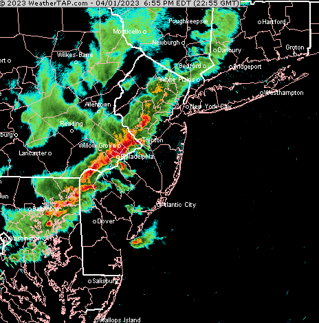
Update Sat 4/01 9:44 PM — Despite the tornadic radar ‘signatures’ seen on radar this evening (inferred from radar differential velocity), the NWS is currently not showing any actual tornado reports except off the coast, near Atlantic City—

Forecast Review

Update Sat 4/01 7:22 PM — Tonight’s storms were impressive, almost scary. Thunder/lightning was almost continuous. Small hail also thrown in for good measure. The ingredients were there. The models did well with the timing and the forecast of the severe weather possibility. The HRRR was particularly impressive, as it often is with this.

Radar with storms just entering Philadelphia 6:30 PM—

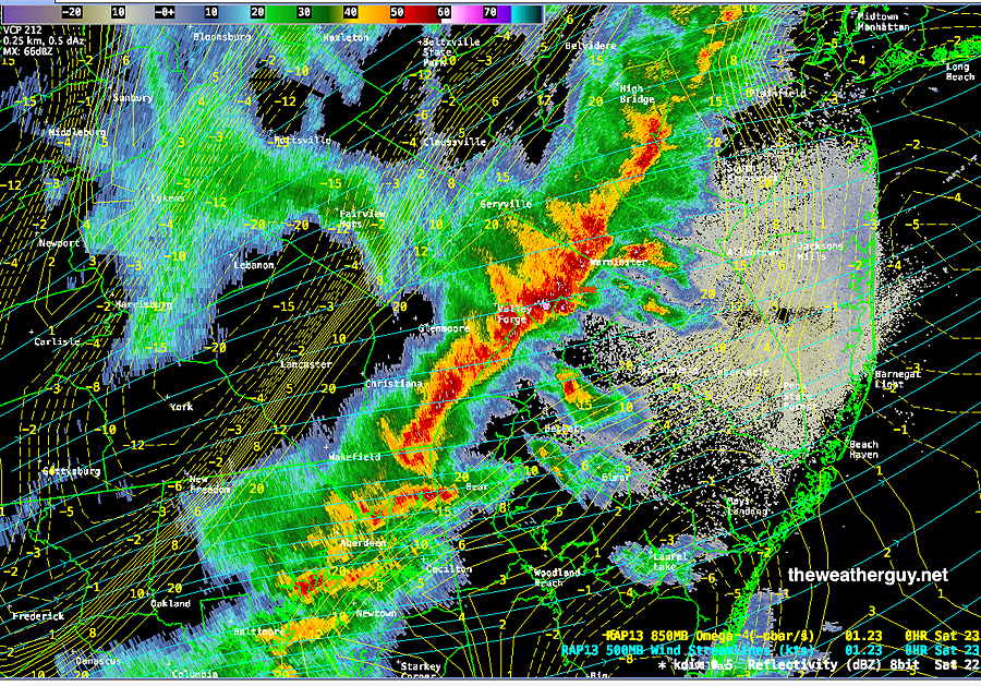
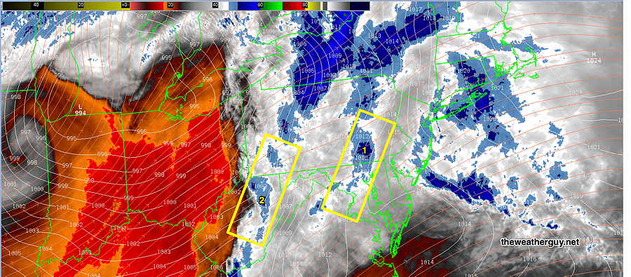
Here’s current NEXRAD radar (~ 7 PM) —

Areas of NJ will likely continue to encounter these severe storms over the next hour or so.

One more thing. The meteorologist on Channel 3 did an excellent job in covering the severe weather. Knowledgeable and impressive.


Storm Potential Update

Update Sat 04/01 @ 10:25 AM — Updated with the 12z NAM-NEST which shows a different potential location of severe weather at 6PM—

12z NAM NEST shows elevated CAPE and Helicity northwest of the city at 6 PM. (Click on image for a larger view.)

Update Sat 04/01 @ 9:42 AM — The important 12z models (those with direct upper air radiosonde/weather balloon measurements) are just becoming available. The HRRR and RAP have become available.

Specifically, the HRRR shows chance of an isolated severe storm in South Jersey as early as 5 PM. The main line of storms moves in between 6 and 9 PM.

Here’s how the ‘severity’ parameters stack up compared to the major storm outbreak of Sept 2021—

9/1/2021 Tornado Outbreak
(example of highly severe)
Todays’s Forecast
HRRR 12z
Comparative Impact
CAPE 3500-4200 Joules/kg2100
Helicity 1350 m^2/s^2655
Vertical Shear 40-4640-45
Precipitable Water 2.7″0.83”⇩⇩
Lifted Index minus 6º Kminus 9.3º
HRRR Hail Parameter 1.91.4
Peak Wind Gusts 40-5040-50
Aligned Storm Motion and Shear Vectors- ~ 90ºAlmost aligned
Jet stream level – wavyHighly cyclonic
Jet Stream 250 mb Speed – 63High 135
500mb – Highly CyclonicHighly cyclonic
Severity Parameters Impact: ⚑ indicates favors Severity ⚐ indicates Possible Severity
↓ indicates works against Severity ⇩ Significant, but less impact

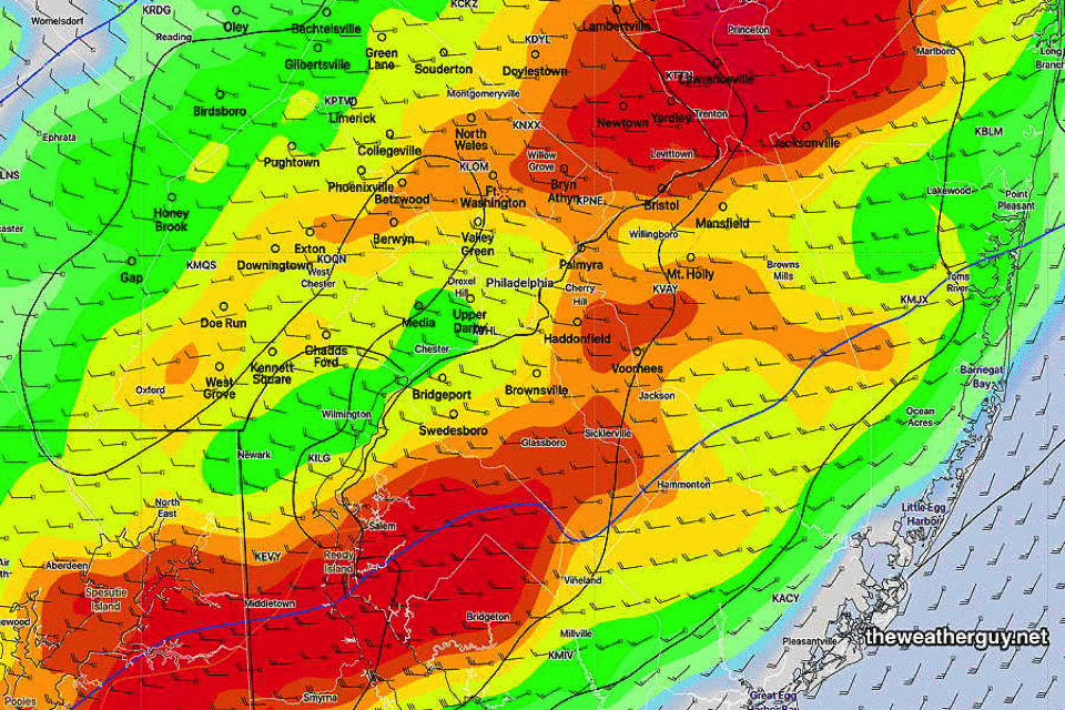
Here’s where the greatest potential for severe weather appears to be at this time (this will likely change)—

Today’s 12z HRRR CAPE/Helicity/Radar forecast for 6 PM Saturday evening. Contours represent helicity. Max helicity South Jersey means some chance of tornadic activity. (Click on image for a larger view.)

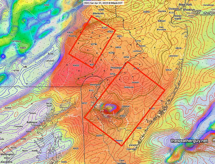
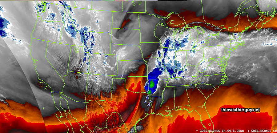
Canadian RGEM Convective (thunderstorm) Precipitation Forecast 7 and 8 PM snapshots—


Update Sat 4/01 7:51 AM — Last night’s models continue with an increased possibility of severe weather this evening. The new 12z HRRR will become available about 9:35 AM. I’ll update before 10 AM.


Update Fri 3/31 10:49 PM — Tonight’s models are showing storm severity parameters that are more impressive for Saturday evening’s storms than previous model runs—

9/1/2021 Tornado Outbreak
(example of highly severe)
Tonight’s Forecast
HRRR 00z
Comparative Impact
CAPE 3500-4200 Joules/kg1900
Helicity 800-1100 m^2/s^2450
Vertical Shear 35-45 30
Precipitable Water 2.0″0.87”⇩⇩
Lifted Index (minus) 7-9 minus 8
Peak Wind Gusts 40-5040-50
Aligned Storm Motion and Shear Vectors- YESYes
Jet stream level – Highly CyclonicHighly cyclonic
Jet Stream Speed – HighHigh
500mb – Highly CyclonicHighly cyclonic
Severity Parameters Impact: ⚑ indicates favors Severity ⚐ indicates Possible Severity
↓ indicates works against Severity ⇩ Significant but less impact

Previously Posted Fri 8:52 PM —

Low pressure will move northeast of us on Saturday. Warm air will be brought up over us from the southwest with rain in the morning. A strong pressure gradient will bring strong and gusty winds. A dry slot from the low will bring some sunshine in the afternoon.

A fast moving cold front moves through early Saturday evening with showers and thunderstorms

Saturday

Rain in the morning, rapidly ending about 12-1 PM from west to east. Sunshine breaks out from the dry slot associated with the low pressure system in Canada.

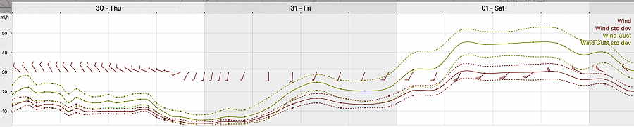
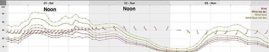
A strong cold front moves through between 6 PM and 8 PM with showers and thunderstorms. Some storms. especially from Philadelphia and eastward into NJ, will be strong, although severe weather not expected. The big issue may be the winds.

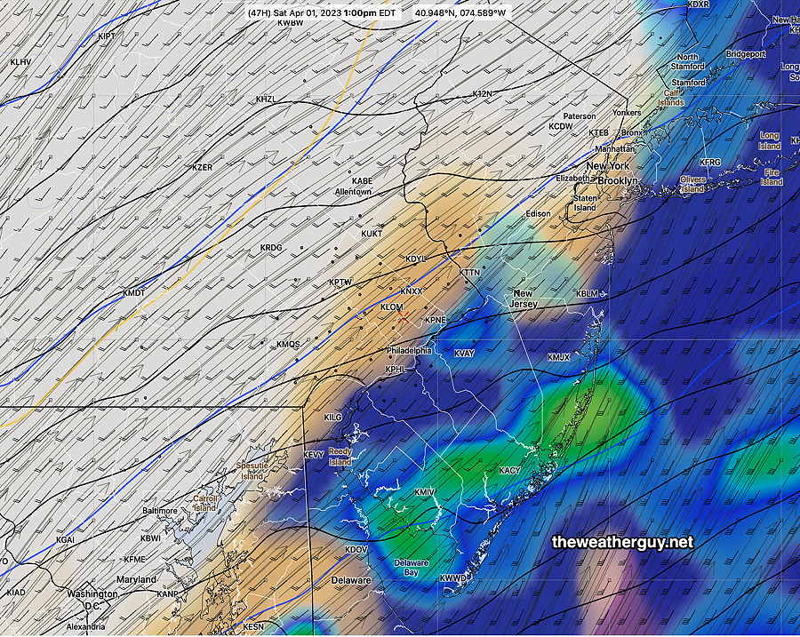
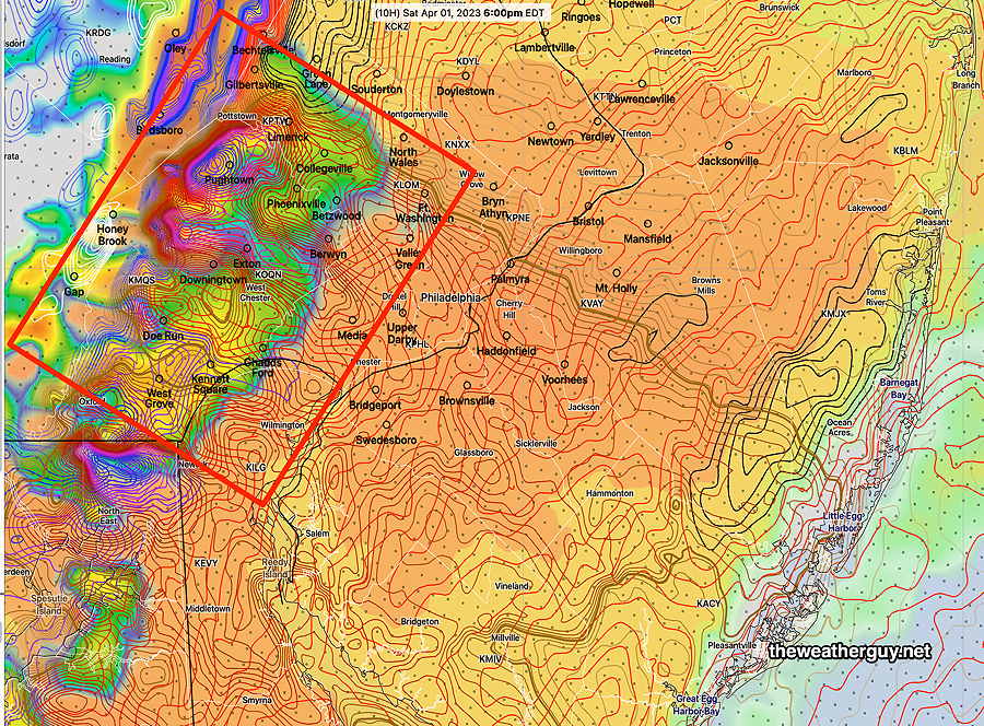
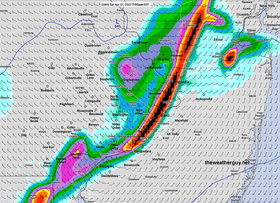
The HRDPS shows a fast moving line of storms at 7 PM Saturday—

Today’s 18z HRDPS shows a line of heavy rain at 7 PM . This will be a fast -moving line. (Click on image for a larger view.)

High temperature 71.3º sd 2.7º ( NBM model location – Blue Bell, PA)

Wind Meteogram (19z NBM) for Blue Bell PA 40-53 mph winds possible (Click on image for a larger view.)

Sunday

Following Saturday’s cold front, winds subside during the day. It will be sunny and unseasonably cool.

High temperature 50.6º sd 2.2º ( NBM model location Blue Bell, PA)


THIS WEEK’S WEATHER

#weather #paweather #wx #pawx #philadelphia

Friday – Saturday Update

Update Fri 03/31 @ 9:13 AM — The cloudiness is moving in as expected and the rest of Friday will be cloudy. No rain expected in our area until around or after midnight.

For Saturday— rain in the morning with a sharp clearing line moving through from west to east about 1-2 PM. It now appears that the second line of showers moving through about 5:30 – 8 PM will have the possibility of strong (not severe) thunderstorms, especially from Philadelphia and eastward into NJ.

I’ll update this evening with my regular Weekend Weather Forecast.


Friday – Saturday Update

Update Thu 03/30 @ 7:34 PM — A major low pressure system approaches and moves through the Great Lakes and Canada. Some changes in the forecast. Friday may have some early sun, but thickening cloud cover by late morning and the rest of the day. Temperatures will actually warm as the day progresses with highest temperatures towards evening.

Most models have the rain now starting somewhat earlier on Friday than previously forecast and have the rain move in about 7-10 PM, but the NAM and NAM-NEST have the showers moving in during the mid afternoon. These models appear to be outliers right now.

Heavier rain on Saturday morning still appears to abruptly end about 1-2 PM with the sun breaking out. (The ECMWF keeps shower around; I’m not going with that.) Some additional showers expected with the actual cold front moving through about 5-8 PM Saturday. It will be VERY WINDY on Saturday and high temperatures will be in the low 70s.

Today’s 18z GFS shows an abrupt back edge of the rain at 1 PM Saturday. (Simulated radar- clouds) (Click on image for a larger view.)


Thursday- Forecast Saturday Outlook

Update Wed 03/29 @ 8:42 PM — A cold front comes through tonight. Thursday will be sunny but chilly.

Friday: A major low pressure system approaches and moves through the Great Lakes and Canada. Increasing clouds on Friday. Rain begins around midnight.

Saturday: Rain in the morning. Rapid clearing about 1 PM. Very mild but extremely WINDY. High 72-75º. Another line of showers may move through about 6 PM Saturday evening with a sharp cold front.

NBM wind meteogram for Blue Bell PA. Note 45-50+ mph gusts on Saturday. (Click on image for a larger view.)

Wednesday Forecast

Update Tue 03/28 @ 7:30 PM — High pressure builds in for mostly sunny skies on Wednesday. Some cloudiness mid to late afternoon ahead of a weak cold front and moisture aloft approaches. Highs mid to upper 50s.

Showers with the cold front are forecast to stay to our north Wednesday night.

Thursday looks a bit cool again.

A warm front moves through Friday. Just clouds expected with the warm front. Rain arrives late afternoon Friday or Friday evening. The rain may depart early Saturday afternoon (GFS) or linger longer (ECMWF).


Tuesday Forecast

Update Mon 3/27 11:28 PM — Tonight’s high resolution models show some light showers possible Tuesday morning


Update Mon 03/27 @ 8:20 PM — The showers moved in about 3 PM and the heavier rain moved in about 5 PM.

A front moved through today and cooler air on northwest winds will bring temperatures down the lower 50s on Tuesday. A few upper air disturbances will also bring considerable periods of cloudiness.

Dry conditions expected through sometime on Friday.


Update Mon 03/27 @ 9:59 AM — Last night’s models suggest the rain moves in later today, closer to 5 PM closer to 4-5 PM.

Today’s 12z HRRR Precipitation Rate at 4 PM. (Click on image for a larger view.)

A series of low pressure systems will affect our weather over this coming week.

Rain from the first system moves in between 2 and 5 PM Monday. The GFS and RAP hold off the rain until after 5, but the majority of the high resolution models bring the rain in earlier, about 2 PM. (Still earlier in western areas)

Today’s 18z GEFS forecast for Monday afternoon showing this week’s systems. (Click on image for a larger view.)

Another system (2) looks to be to our south on Tuesday. A weak cold front (3) moves through late Wednesday. By Friday afternoon, a large system (4) may affect us through Saturday.