THIS WEEK’S WEATHER

#weather #paweather #wx #pawx #philadelphia

Continuing Forecast Change For Sunday

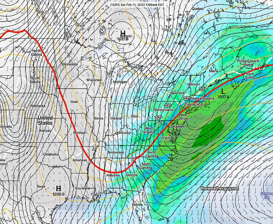
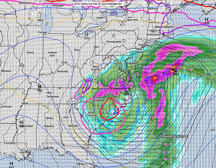
Update Thu 02/09 @ 8:57 AM — Regarding the coastal storm that is now forecast by all models to develop Sunday, the latest GFS keeps any significant rain out of the immediate PHL area until after midnight Sunday into Monday morning. A few other models have light rain moving in after 6 PM–

06z German ICON model forecast for 7 PM Sunday night (Click on image for a larger view.)

Continuing Forecast Change

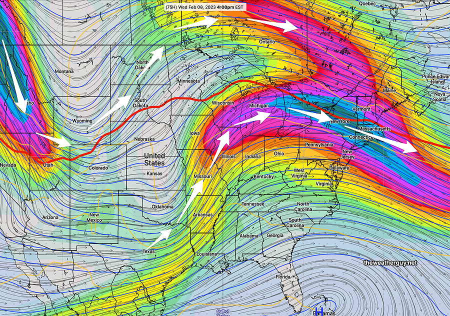
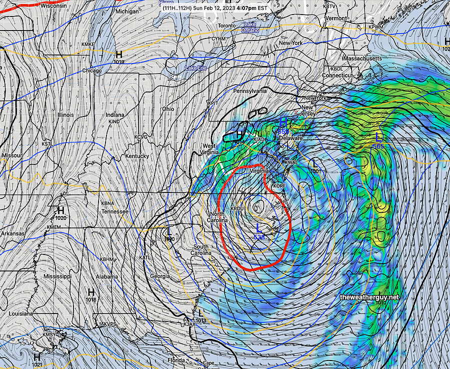
Update Wed 02/08 @ 6:21 PM — Today’s models have moved away from having the coastal storm progress northward very much on Sunday and will likely skirt to our south later Sunday night into Monday.

Here’s the latest GFS—

Today’s 18z GFS forecast for 5 PM Sunday. (Click on image for a larger view.)

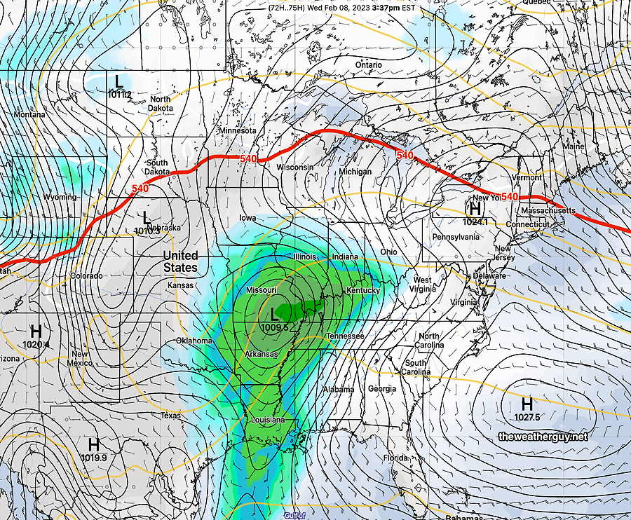
Interesting Weather Possible Sunday

Update Wed 02/08 @ 8:39 AM — The complexity of the weather setup for this weekend has been a challenge for the numerical weather models, and over the past week or so, I’ve been watching this scenario evolve.

The GFS forecast for this weekend over past days has been described as an ‘outlier’ by the NWS chief forecasters, but interestingly, last night the ECMWF joined the ‘outlier’ GFS in forecasting a closed low and a coastal storm for Sunday!

In a “normal” winter, this might pose the potential for major coastal snowstorm, but this winter and this weekend, the thermal profiles are quite complex. As a result, the precipitation type will be a difficult forecast, but it is still leaning heavily towards rain here.

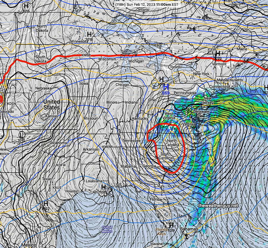
The current forecast track may keep it from moving further north than shown below at 4 PM Sunday—

ECMWF forcast for Sunday 4 PM (Click on image for a larger view.)

GFS—

GFS forecast for 4 PM Sunday. Closed off mid level low captured by the red 540 thickness line. Click on image for a larger view.)

Nonetheless, an interesting setup. (While it’s going to be too warm for snow here, should the closed low (red circle) move up over us, it will be a different ball game.)

My regular readers here know that when a mid-level or upper level low closes off, forecasting movement and track of the surface low and the precip can be daunting. Stay tuned.


Forecast Uncertainty

Perhaps people have noticed that the forecasts the past two days haven’t been the best. Yesterday was supposed to be sunny but it was very cloudy in the afternoon. Today was supposed to be cloudy in the afternoon, but the cloud cover was very thin and the sun shone through.

Clearly, we’re in a pattern the models are having trouble with. Which brings us to the forecast dilemma for the end of the week into the weekend.

There remains significant differences in the model forecasts for the coming weekend. It’s been like this for days.

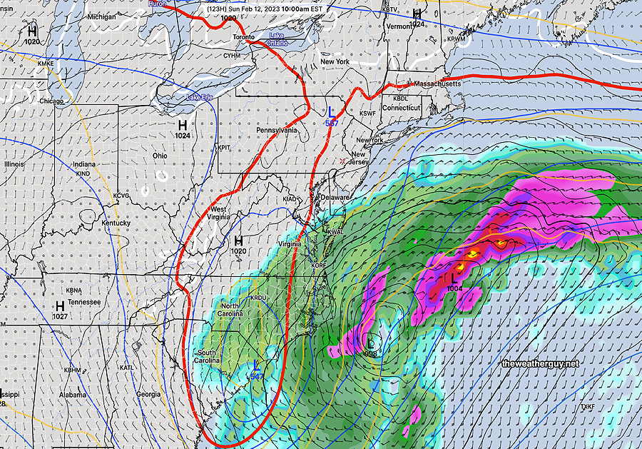
Here’s the latest GFS for 10 AM Sunday. In a “normal” winter there might be worries about a major coastal snowstorm, (but not this winter and not this weekend.)—

GFS forecast—

GFS forecast for 10 AM Sunday. There is a closed mid level low. (Click on image for a larger view.)

As ominous as that map looks, here’s the current ECMWF forecast showing the storm further south and east that will shear out to sea —

ECMWF forecast for Sunday 10 AM. The storm will shear to our east, missing us. There is no mid level closed low. (Click on image for a larger view.)

So we have two very different forecasts for the weekend, particularly Super Bowl Sunday. I’ll be honest…I have no idea what the weather will be this Sunday. While I’m at it, there’s too much uncertainty even Friday and Saturday. Hopefully things clarify.

When was the last time you heard that with the TV weather entertainers?


THIS WEEK’S WEATHER

#weather #paweather #wx #pawx #philadelphia

Update Mon 02/06 @ 10:04 PM — Still no sign of any snow through Feb 18th. In fact, after a chill down this coming Super Bowl Sunday, things warm up again.

Mon 9:56 PM Forecast Review — There was much more cloudiness than I had forecast today, and for that matter, anyone else had forecast. In review, I could not find a model from last night or early this morning that had forecast the cloudiness we experienced. It was caused by an area of strong vorticity and moisture. These upper air triggered disturbances just aren’t always modeled well. Tomorrow will become cloudy as well

This week’s weather will be influenced by a flat to ridge configuration of the jet stream, with the jet north of our area, allowing milder conditions.

Monday will be windy and sunny. The winds the result of a nearby deep low pressure system in the Atlantic.

A weak cold front will pass through early Tuesday morning.

Wednesday will be the nicest day, with a possible runner-up on Thursday.

The 500-1000mb (540) thickness (red line) gives a quick, general position of the jet flow. Here’s the GEFS forecast for Wednesday—

Today’s 18z GEFS model forecast for Wednesday afternoon. A southwest flow around a Bermuda high-like system will bring milder air. The 540 thickness line (red) is to our north. (Click on image for a larger view.)

Here’s the actual depiction of the jet stream (300 mb level winds). Notice where the superimposed 540 thickness level is —

GEFS jet flow and superimposed 540 thickness. We actually have split jet flow, making the forecast complicated. (Click on image for a larger view.)

Large questions marks emerge after Wednesday with expected changes in the jet flow. The forecast is unclear at this time, especially for Friday through Saturday.

This past weekend, I saw the first possible signs of a potential coastal snowstorm and posted that possibility. That possibility has since faded, but high forecast uncertainty is still the message. If there will be any snow, it now appears to be in western PA.

Here’s the latest GEFS forecast for Saturday—

Latest 18z GEFS forecast for Saturday at 1 AM. Notice the red 540 thickness line has taken a sharp dip, but is still “tilted positively” (bend up towards the east) . Notice the position of the white 32º surface temperature line. Rain for us, unless the jet becomes even more amplified and negatively tilted.