Update Mon 02/06 @ 10:04 PM — Still no sign of any snow through Feb 18th. In fact, after a chill down this coming Super Bowl Sunday, things warm up again.
Mon 9:56 PM Forecast Review — There was much more cloudiness than I had forecast today, and for that matter, anyone else had forecast. In review, I could not find a model from last night or early this morning that had forecast the cloudiness we experienced. It was caused by an area of strong vorticity and moisture. These upper air triggered disturbances just aren’t always modeled well. Tomorrow will become cloudy as well
This week’s weather will be influenced by a flat to ridge configuration of the jet stream, with the jet north of our area, allowing milder conditions.
Monday will be windy and sunny. The winds the result of a nearby deep low pressure system in the Atlantic.
A weak cold front will pass through early Tuesday morning.
Wednesday will be the nicest day, with a possible runner-up on Thursday.
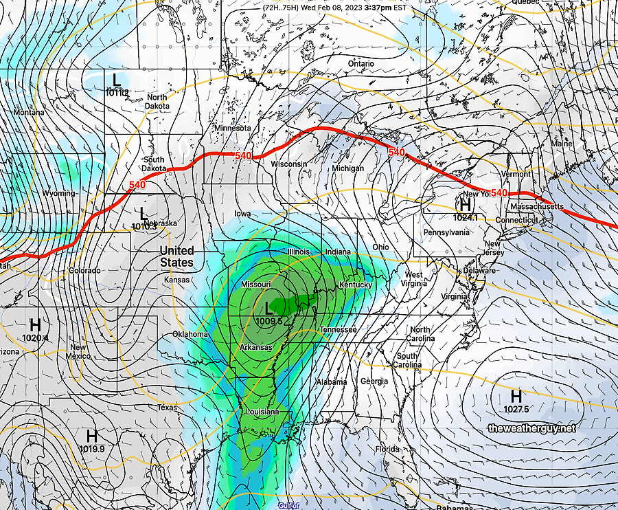
The 500-1000mb (540) thickness (red line) gives a quick, general position of the jet flow. Here’s the GEFS forecast for Wednesday—
Today’s 18z GEFS model forecast for Wednesday afternoon. A southwest flow around a Bermuda high-like system will bring milder air. The 540 thickness line (red) is to our north. (Click on image for a larger view.)
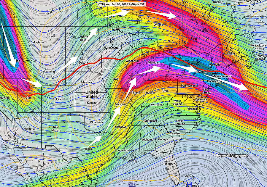
Here’s the actual depiction of the jet stream (300 mb level winds). Notice where the superimposed 540 thickness level is —
GEFS jet flow and superimposed 540 thickness. We actually have split jet flow, making the forecast complicated. (Click on image for a larger view.)
Large questions marks emerge after Wednesday with expected changes in the jet flow. The forecast is unclear at this time, especially for Friday through Saturday.
This past weekend, I saw the first possible signs of a potential coastal snowstorm and posted that possibility. That possibility has since faded, but high forecast uncertainty is still the message. If there will be any snow, it now appears to be in western PA.
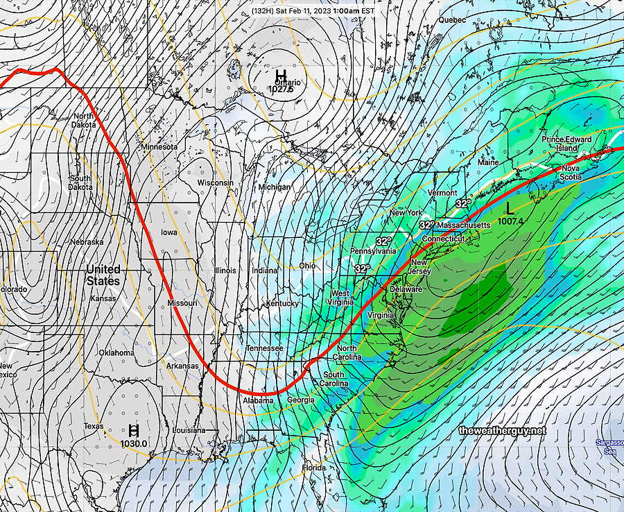
Here’s the latest GEFS forecast for Saturday—
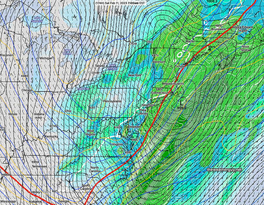
Latest 18z GEFS forecast for Saturday at 1 AM. Notice the red 540 thickness line has taken a sharp dip, but is still “tilted positively” (bend up towards the east) . Notice the position of the white 32º surface temperature line. Rain for us, unless the jet becomes even more amplified and negatively tilted.
A quick update. Tonight’s models are back to showing considerable mid level cloudiness developing Sunday afternoon from warm air moving up aloft and a low pressure system brushing South Jersey.
Update Sat 02/04 @ 3:42 PM — The latest run of the ECMWF has backed away from the potential snow and is more in line with the other ensemble models. There are still huge timing issues between today’s GFS, the Canadian and ECMWF, so uncertainty remains high. However the likelihood of a coastal snowstorm has become unlikely now. That snow possibility didn’t last long.
First, an observation. Today’s adjusted mean sea level pressure was 30.68″. For you barometers fans, that doesn’t happen here very often. (Average sea level pressure is 29.92″ and typical barometric pressures with sunny cold weather is in the 30.25″- 30.35″ range.) Readings above 30.60 are the result of very cold, dense air, something that should be no surprise if you’ve stepped outdoors today.
Possible Snow
There haven’t been many (maybe any) possibilities of snow this winter season. A few marginal possibilities on the extended forecast models all have fizzled out. A possibility has begun showing for next Friday through Sunday time frame.
The global models forecasts extend out to 384 hours (15.5 days) but you don’t have to be a meteorologist to know that forecasts beyond 3-4 days have increasing uncertainty. Once you get into the 5+ day range, meteorologists primarily use “ensemble” models, models that try to statistically account for modelling error, input data errors, model biases, and chaotic effects.
Today’s GFS and GEFS (ensemble) and Canadian Ensemble (GEPS) along with the ECMWF are suggesting the formation of a coastal low the end of next week. A giveaway of the uncertainty with this potential system is the wide range in the timing, from late Friday night to late Saturday night.
Here’s the ECMWF for next Saturday night—
00z ECMWF forecast for Sunday at 1 AM shows coastal low, cold air and deep dip in the jet stream (as captured by the red 540 thickness line) (Click on image for a larger view.)
The NAEFS which combines the GEFS and the Canadian GEPS (ensembles) has different timing and somewhat warmer forecast—
Todays 06z NAEFS forecast for 7 AM Saturday shows wraparound moisture with 32º line(white) just through Philadelphia. This is a rain to snow event, according to this model that occurs almost 20 hours sooner. (Click on image for a larger view.)
So for you people wondering about possible snow here, this setup is as close as we’ve seen forecast-wise this season. BUT the difference in timing suggests terribly high uncertainty and the possibility that this snow forecast fizzles out is well above average. If you like snow, don’t get your hopes up quite yet.