SNOW UPDATE

Forecast Updated 10:50 PM — Tonight’s GFS just available continues with the high snow totals, even in Philadephia, similar to those earlier today.     I  guess we’ll have to ignore the NAM group of models low snow totals.


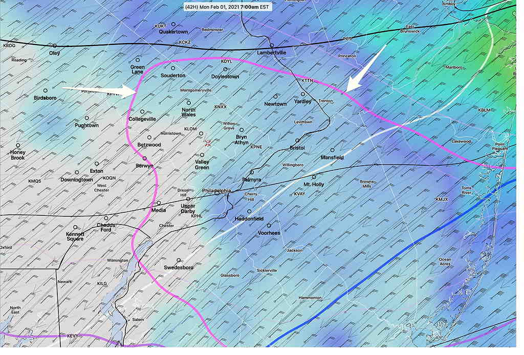
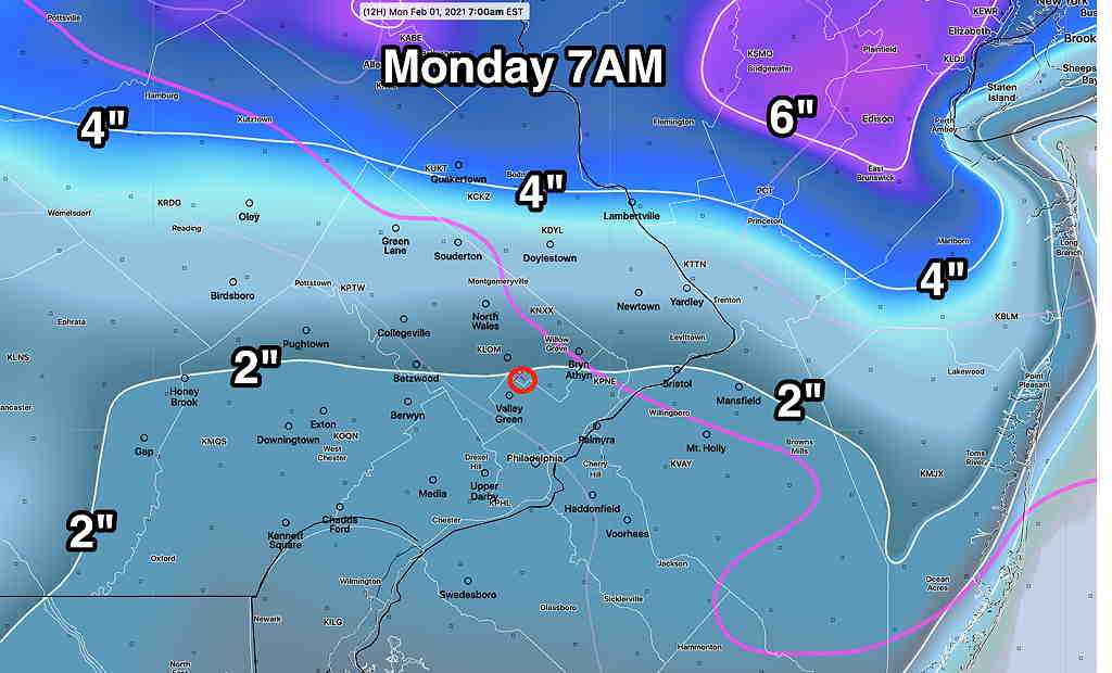
Forecast Updated Sun 9:12 PM — Tonight’s NAM model has become available.  The NAM model continues to show a significant mixing with sleet after midnight as the warm front event continues.  Total snowfall at at 7AM is unimpressive around the city—

NAM Snow totals 7 AM  (Click on image for a larger view.)


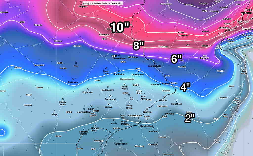
The NAM has most of the accumulation resuming after 11 AM Monday as everything changes back to snow.

By 7 PM —

NAM Snow totals 7PM  (Click on image for a larger view.)

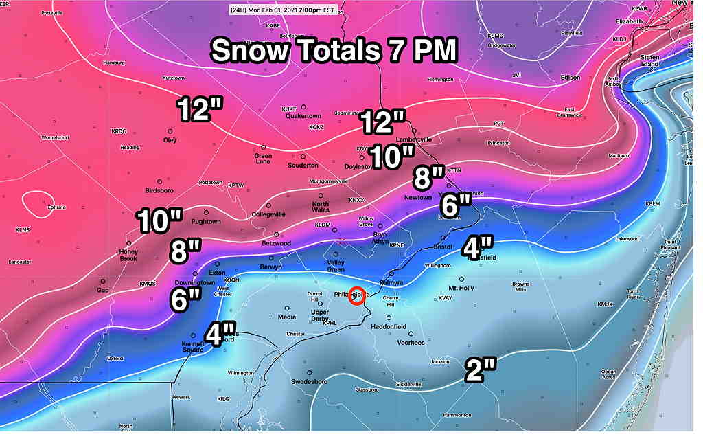
Some snow continues into the evening hours.

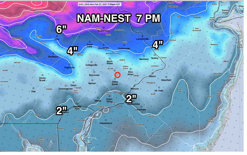
Even less impressive is the higher resolution NAM-NEST

NAM NEST 7 PM Monday (Click on image for a larger view.)


Be advised that most of the models today have continued with the much higher amounts that are highly advertised in the news.   And those models may very well be correct.  But one has to take into account that the NAM group has much more sleet and lower snow totals, especially near the city.   

The GFS group and other models become available about 10:50 PM.  It might be too late to do graphics, but if things change significantly, I’ll update after 11 PM.  Otherwise, look for an update tomorrow morning.


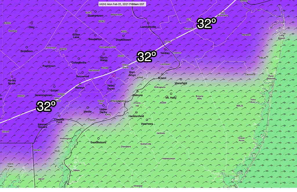
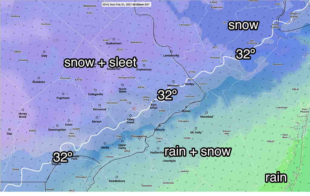
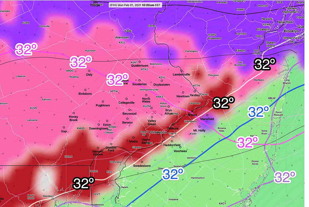
Forecast Updated Sun 3:56 PM — Despite the impressive snow totals predicted by most of the models, the NAM continues to forecast much lower snow totals.  The afternoon NAM just became available.  The NAM is insistent on showing temperatures at 6000 feet (800 mb) to be above freezing, mixing the snow with sleet and reducing snow totals by at least 1/2  compared to the GFS model.   Below is the current forecast position of the NAM 32º (~6000 ft)  isotherm at 10 AM Monday.  Areas south and east of this line may have significantly reduced snow totals if the NAM is correct—

NAM 32º isotherm (pink) at 6000 feet.  (Click on image for a larger view.)


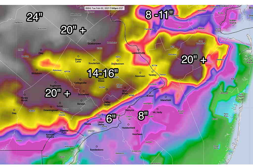
The NAM-NEST and Canadian High Resolution are similar. Despite the impressive high snow total headlines of the other models,it’s never good to ignore the NAM model”.
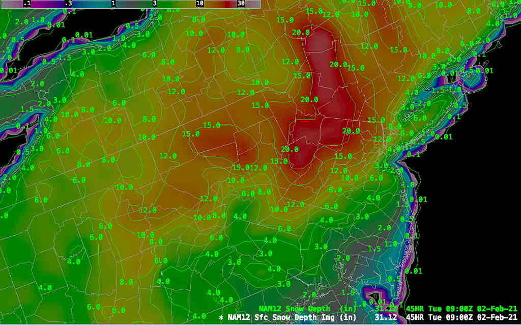
NAM Snow totals—

NAM snow totals by Tuesday morning (Click on image for a larger view.)


In past storms, the average between the GFS and NAM has been a better forecast when there’s been so much divergence.  


Updated Sunday 2 PM— more graphics added at the end of this post…

The morning models have come out.  The models are in fairly good agreement forecasting a significant snowfall for our region. There is still some issue with a warm layer moving in at 6000 feet (800 mb)  which would reduce the accumulation in Philadelphia, south and east.   The latest GFS is colder and has more QPF than previous runs.

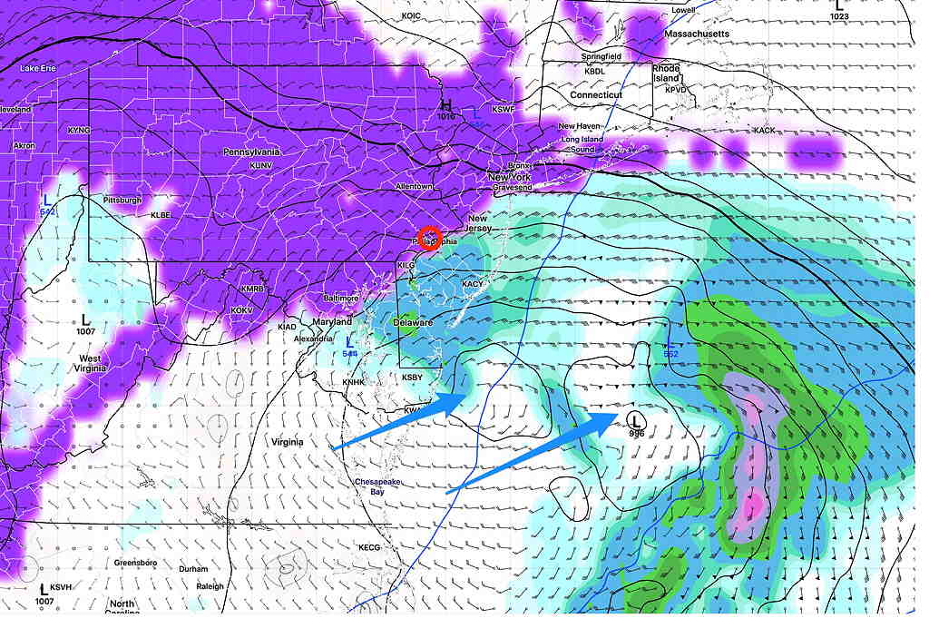
This will be a prolonged event with a warm front (warm air advection snowfall) followed by a blocked, slow-moving coastal secondary low. The snowfall totals quoted below are through Tuesday evening.

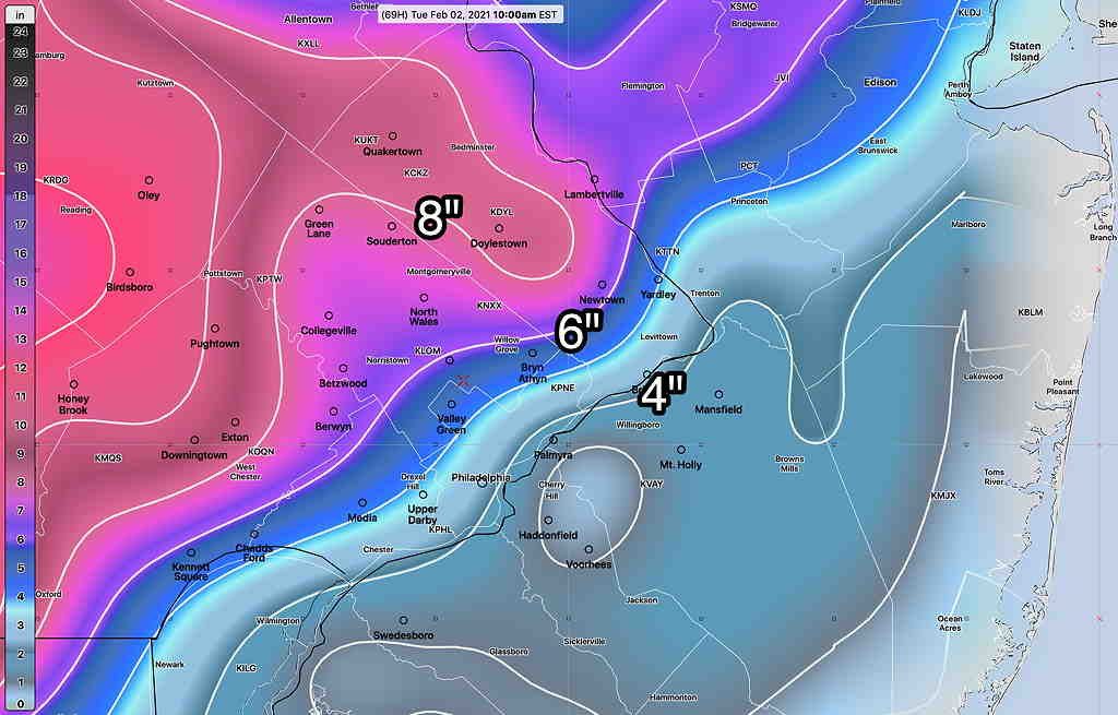
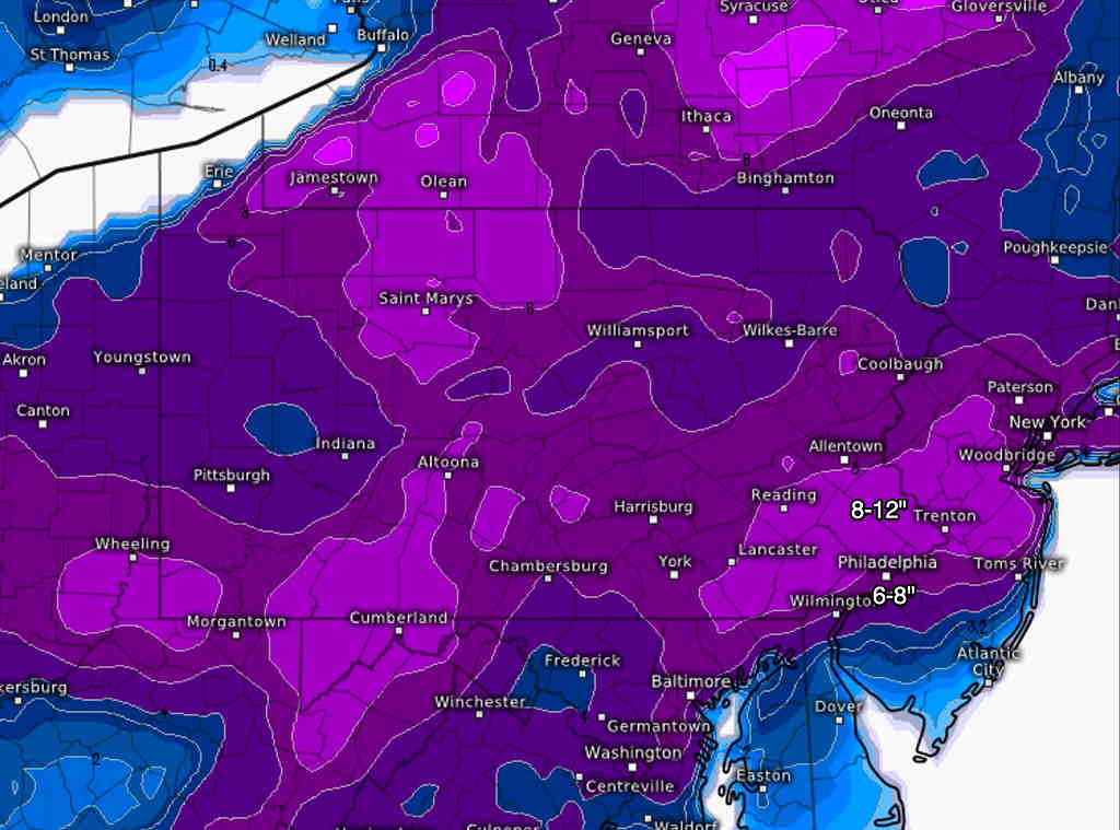
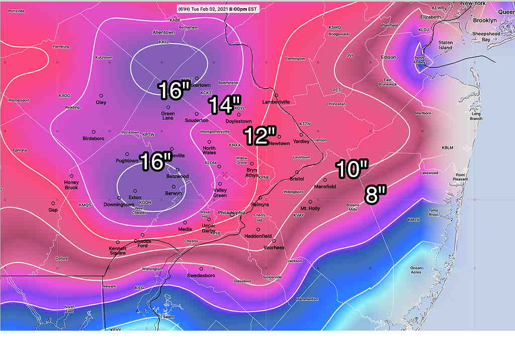
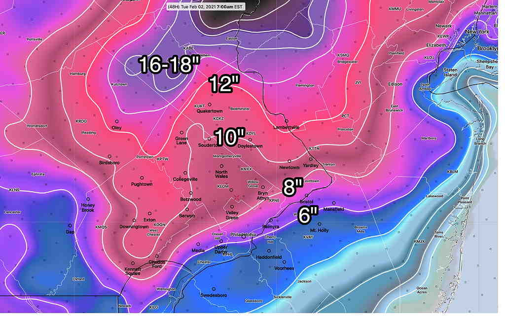
The latest GFS model data provides a reasonably good estimate of the currently expected snowfall totals. It’s inline with many of the other models, perhaps on the high side.  But it’s the latest —

GFS snowfall by Tuesday evening.  (Click on image for a larger view.)


Additional snow total graphics added below at 2 PM:

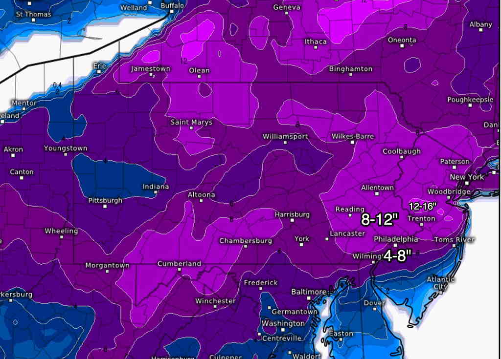
The latest ECMWF snow totals—

ECMWF snowfall totals  (Click on image for a larger view.)


German ICON model

German ICON model snow totals  (Click on image for a larger view.)


High Resolution Window FV3 (experimental) model—

Experimental HIRESW (High Resolution Window) Snow-Liquid equivalent 1:10 ratio without compaction  (Click on image for a larger view.)


Canadian Regional GEM model

Canadian Regional GEM model  (Click on image for a larger view.)


For the record, the NAM has warm air moving in at 6000 feet, reducing the above snow totals by about half near Philadelphia.  With so many models at the higher end, I’m ignoring the NAM snow totals.  (The NAM QPF values are consistent with higher snow totals.) 

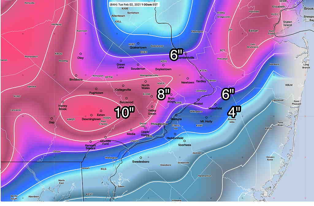
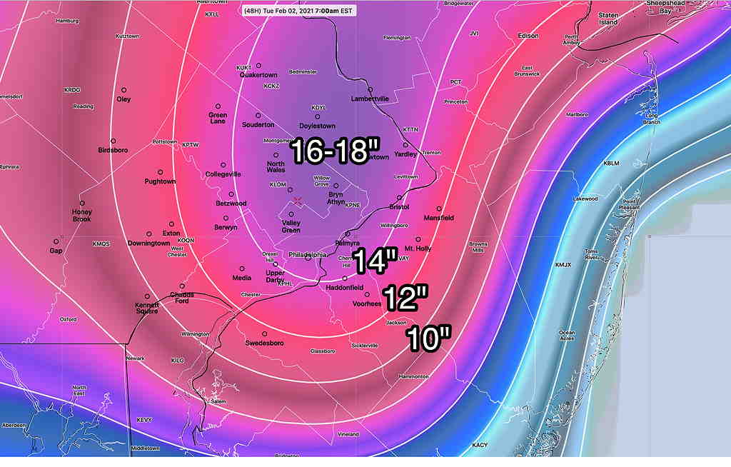
Here’s the NAM model snow totals (without the fancy graphics).  It forecasts a fraction of the other models snowfall near Philadelphia—

NAM snow totals  (Click on image for a larger view.)


More updates later today.  Stay tuned…


SATURDAY’S SNOW UPDATE

Forecast Update Sun 8AM —  Quick update.   Snow starts between 2PM and 4PM this afternoon from south to north.  Accumulations 9-12 inches from Philadelphia, including much of the city and northward.   Higher (12+) accumulations northern Montgomery and Bucks and Lehigh  counties.  I’ll have more info based on the morning’s models later .   Stay tuned. 

Next Update about 1PM Sunday


Forecast Update Sat 6 PM— This remains a high uncertainty, low confidence forecast. 

The NAM group of models has a significant mix with sleet and rain, but maintains surface temperatures below freezing in most of Philadelphia. More freezing rain.  The NAM was wrong in the same direction this past week and its snow totals are running 2 inches or more less than the GFS model (shown just below).

NAM 7AM Monday with 32º isotherm at about 6000 ft  Warm air aloft will create precip mix and reduce snow totals. (Surface temps, white line is 32º.)   (Click on image for a larger view.)


The GFS group of models is warmer at the surface, but also has a rain sleet snow mix for almost 8 hours from midnight Sunday through part of Monday morning.  Despite a QPF of 1.5 inches of water, it cranks out only about 6 inches of snow (Blue Bell).

GFS PTYPE forecast 7 AM Monday. (Click on image for a larger view.)

 GFS snow totals based on latest model run this afternoon—

GFS snow totals Tuesday by Tuesday morning. (Click on image for a larger view.)


The Canadian models have 2-3 inches more snow than the above.  The NAM 2-3 inches less!


Look for an new update Sunday morning!


from Sat morning…

This remains a complicated forecast.  There are uncertainties about the low pressure system track, timing and degree of intensification.    All of these uncertainties affect the amount of moisture falling as snow, the temperature profile (meaning 3-D profile) and the duration of the storm.

The general sequence has not changed.  A “warm air advection type snow (warm  front)  will occur Sunday afternoon where warm air rides above a cold layer at the surface.  About 1 ” of snow is possible by early Sunday evening in most areas. 

Meanwhile, a secondary low pressure system will develop along the coastline and will move slowly northeastward, being blocked by a high pressure ridge in the mid Atlantic.  This will result in additional snow, lasting into late Monday night!

The main complication is the amount of warm air at 3000-6000 feet that moves in with the initial warm front and the subsequent development of the coastal low bringing those same 3000-6000 ft temperatures below freezing.

Further complicating the picture is the development of the secondary low circulation that is multilobular with at least two circulation centers—

GFS surface forecast showing two centers at 9 AM Monday.  The GFS has shown this for at least a day. This further complicates the forecast for the precipitation field and the thermal profile.  (Click on image for a larger view.)

Switching to the model blend (NBM), which is designed to take most available models and statistically weight/blend them based on history and hourly changes, it shows mixed precipitation Monday morning with surface temperatures above freezing—

NBM Precip TYPE at 10 AM Monday  (Click on image for a larger view.)

This mixed precip will further complicate accuracy of snowfall prediction.

All models have the mix changing back to all snow during the afternoon and evening Monday. 

The current European (ECMWF) model has the following snow totals—

ECMWF snow totals early Tuesday morning  (Click on image for a larger view.)


My own snow totals, based on variation of the NBM 50 percentile snow accumulation—

NBM snow totals based on modification of snow accumulation 50 percentiles  (Click on image for a larger view.)

I expect changes as the storm time horizon falls into the range of more short range models.  Stay tuned.


Just added Sat 10 AM: NAM PTYPE with 32º isotherms at critical 3 D levels

Latest NAM with precipitation type and freezing isotherms 10 AM Monday forecast  (Click on image for a larger view.)