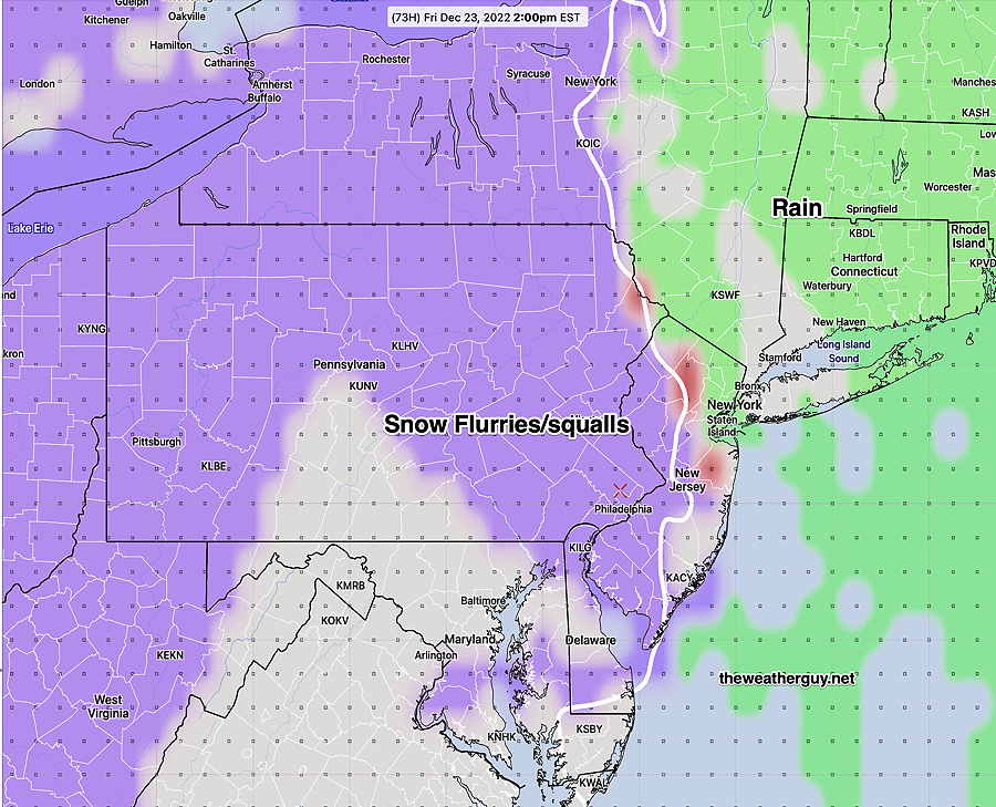
Category Archives: Winter Storm Outlook

SNOW STORM SUNDAY

Mon 10:19 AM —Forecast Review — As the models moved into the final 24 hours, the forecast was pretty good.

The storm was first forecast over 8 days in advance by the AI models.

By Saturday, the models had refined the transition to sleet around noon to 2 PM, which was spot on. Freezing rain was over-forecast.

The total precipitation was about 1.3″ water, less than the 1.6″ forecast, so snow totals were lower than forecast.

The NBM mean snow forecast was closer than the median forecast.

The storm ended about when it was forecast that day (9 PM in the city) but earlier than previous day’s forecasts which had it extending into Monday and Tuesday. Some additional precipitation occurred through 11 PM.

The RRFS model , soon to become operational, which was very low on the precipitation forecast for several days in advance, but came closer to the actual by late Saturday in its 24 hour forecast.

Official NWS snow Totals—

Storm Review and Other Thoughts

Posted Sunday 01/25/26 @ 5:03 PM — The latest models show the mix tapering off significantly over between 6 and 9 PM near the city. A visitor to the site informed me that my blog settings had closed the comment feature to additional comments. I’ve corrected that issue. The same visitor asked about sleet freezing rain and snow—


“I’m wondering what the difference is between sleet and freezing rain. How do they impact things like shoveling and just getting around after this storm”

Well there’s a simple graphic that explains the difference and it comes down to this: the precipitation type depends how thick a layer of warm air (air temperature above 32º) the precipitation must fall through before reaching the ground.

Different thicknesses of air above 32º will result in different types of precip as shown below. (Click on image for a larger view.)

As for the following advise, I’m no expert. But the worst thing is letting the freezing rain and sleet hit the cold concrete. So I like to wait until the storm is over before shoveling, keeping the ice-sleet as the top layer. Otherwise you’ll have to contend with removing ice bonded to the ground. Of course one has to balance the total depth/weight and your ability to shovel it, so the incremental approach might work for some. I think ice is worse than snow when walking, driving etc.

As for the storm, it looks like the models over-estimated the snowfall. The near 10″ turned out to be close near the city, but still high. Here’s the official snow depth measurements for our area.


Changing Over

Posted Sunday 01/25/26 @ 12:17 PM — The snow is changing over to sleet early in the expected time window about 12 noon in my neck of the woods. We have about 7.5″ at the time of the changeover.

The RRFS runs every hour. Here’s the latest precipitation type forecast. I’ve drawn in the temperatures at around 6000 feet and about 3000 feet—

15z RRFS forecast for just after noon with precipitation type and thermal level temps. (Click on image for a larger view.)
A Note

Over the years, readers have written to me asking “what is the best radar and weather data app on the Apple App Store”. After trying so many apps, I recently discovered a contender for the best live weather and radar data— WeatherFront. The NEXrad radar on this app is as good as anything out there and its animations are real time. I pay for the added features and to support the developer, but an incredible amount of the data is available for free. Try it out! (I have no financial interest or gain in this app nor do I know anything about the developer. )

WeatherFront Screen capture live MRMS national view. (Click on image for a larger view.)

I should add that all the weather model graphics you see on this site are created using my own downloaded and post-processed model data and displayed with the weather model grib2 display app called LuckGrib on MacOS. I’ve customized the graphics displays, which LuckGrib fully facilitates. LuckGrib is also available for iPad and iPhone. LuckGrib does supply a range of model downloads at no charge, although I don’t use that feature. LuckGrib is a gem. Highly recommend it. (I have no financial interest or gain in this app nor do I know anything about the developer. except the developer is a top class programmer. )

Storm Update -Sunday

Posted Sunday 01/25/26 @ 10:21 AM — The snow began as forecast between 2 and 4 AM and the storm is playing out as forecast.

Based on a review of last night’s models and comparison with current conditions in the RTMA model, it appears that the NBM median snow totals is a best estimate. (plus or minus 2 inches) Here’s the NBM 07z median forecast, just before the snow started—

07z NBM model median forecast. Median = Half the models comprising this ensemble are showing more than these values, half are showing less. (Click on image for a larger view.)

Transition from snow to sleet is predicted by the 13z NBM to occur near the city between 12PM and 1 PM

13z NBM snow to sleet transition betweeen 12 and 1 PM (Click on image for a larger view.)’

Between 7 and 8 PM, the NBM shows this transition to have occurred—

13z NBM precipitation type between 7-8 PM (Click on image for a larger view.)

I wanted to get this online. More info coming.


Sunday’s Storm Forecast Update

Posted Saturday 01/24/26 @ 4:09 PM — I’ve looked at multiple models and here are the trends for Sunday’s snow/sleet storm—

  • Depending upon the model, light snow starts near the city between 1 AM and 4 AM, earlier in southern Chester county.
  • Very heavy snow expected Sunday morning. The snowfall may exceed 1 inch per hour.
  • From noon to 3 PM, the snow mixes with and changes to predominantly sleet, although a mix may re-develop if dynamic cooling brings the temperatures aloft down.
  • Temperatures rise from 3 PM to 10 PM but remain below freezing from the I-95 corridor north and west. Sleet followed by freezing rain likely from the city and north and west. Dangerous icy buildup possible.
  • East, in NJ, a transition to rain is expected during the 3 PM to 10 PM time frame.
  • Many models have the precipitation end about midnight. The HRRR has periods of sleet transition back to snow as late as 9 AM Monday.

As for snow totals, they have remained fairly constant over today’s models with the 10″ number highly predominant. The graphics below capture the likely snow totals—

12z ECMWF-AI Total snow accumulation. (Click on image for a larger view.)
19z NBM median snow totals (half the models are above these levels, half are below this levels.) (Click on image for a larger view.)
19z NBM MEAN snow totals. (Click on image for a larger view.)

The earlier GFS model also clustered around 10″.

Some thoughts: The soon to be released RRFS model seems to be an outlier with snow totals in the 4″ -7″ range and a rapid end to the storm. Either the RRFS is not ready for prime time or it is so advanced that it ‘knows’ some thing the other models don’t. I guess we’ll find out.

Another thought: Regular visitors here know that I often post expected rain totals. Those numbers are never exactly correct. They can only be ballpark estimate.

For some reason, when it comes to snow, weather forecasters (and I guess I have to include myself in that) erroneously believe we can nail down snow accumulations to the inch. The irony is that snow totals are based on the expected precipitation (basically rain snow equivalent) where any error is magnified by a multiplier of typically 10 x. Put another way, nobody gets upset if we get 0.2″ of rain instead of 0.4″ of rain. But with snow, it’s 2 inches vs 4. Just something to think about.

Storm Forecast Update

Posted Saturday 01/24/26 @ 9:32 AM — The storm is now well within the forecast time frame of the higher resolution models. The latest HRRR, just available, shows the snow starting around 4 AM (Blue Bell grid point) and ending for the most part by 10 PM with a changeover to a mix of sleet and freezing rain about 2 PM. A snow sleet mix is likely for an hour or two more.

Despite the changeover, it’s predicting accumulations in line with yesterday’s NBM median and mean forecasts—

Todays 12z HRRR snow accumulation through 10 PM. (Click on image for a larger view.)

The reason is most of the accumulation of the snow will occur before the changeover, essentially before 2 PM Sunday. However, an additional 1/2+ inch of ice and sleet will fall, which will accumulate on top of the snow after 2 PM. This will be heavy, and will likely be a hazard to trees and power lines.

HRRR snow accumulation meteogram for grid point Blue Bell – Wings Field. Snow starts about 4 PM. The major portion of the snow depth occurs before 2 PM. (Click on image for a larger view.)

More updates to follow. Stay tuned.


Storm Forecast Update

Posted Friday 01/23/26 @ 11:16 PM — Another quick update. The 01z NBM has the median snow totals about 2-3 inches lower than the previous 19z model graphics posted earlier. The reason- the changeover to sleet may occur as early as 2-3 PM. Updates in the morning.

Posted Friday 01/23/26 @ 8:49 PM — One more thing… I’m noticing the changeover to sleet and freezing rain may occur earlier in the afternoon Sunday and the push northwestward is all the way to Berks and Lehigh counties during the evening. This may further reduce snow totals.

Updates in the morning…


Storm Forecast- Late Friday Update

Posted Friday 01/23/26 @ 4:27 PM — I’m reviewing various models. As explained yesterday models have various ways of providing snow accumulation data. Many are not all that useful. Basically, models calculate snow from expected total water precipitation and using various algorithms involving snow-water ratios (temperature-dependent through the lower atmosphere) they compute the snow (referred to ASNOW or accumulating snow) Some only compute snow depth which includes density, compaction and melting (SNOD- snow depth) . Some only provide the water equivalent of accumulated snow depth (WEASD). It’s a mixed bag. And some models (like the ECMWF) only provide snow accumulation to paying subscribers.

As one of the people leaving a comment today accurately recalled, I used to use the NAM model data preferentially. Specifically, the NAM total precipitation in inches of water, multiplied by 10. I’d average that with the GFS precipitation similarly multiplied by 10. Based on temperatures at certain levels, I’d change the multiplication factor.

Very primitive but it works. But it really only works when it’s an all-snow event. This storm will have a sleet mix in that throws that simplistic approach out the window.

The model blend (NBM) uses very advanced statistical approaches in analyzing multiple model precipitation. The NBM is updated and run hourly, but the 01z, 07z, 13z, and 19z model runs have a special emphasis on precipitation. I’ve found it to be quite good and that’s what I’ve been leaning on.

Enough about that. What about the snow? Here are some model snow forecasts from this afternoon and this morning. The trend is downward, not because of less total precipitation (water equiv) but because part of it will fall as sleet and freezing rain—

Model NameBlue Bell Grid PointComments
ECMWF-AI 9.0″SRATE based
ECMWF~ 9.0″Derived from Snow Water Ratio
GFS9″SNOD
AIGFS10″No Snow Parameter Derived from Snow Water Ratio
Canadian RGEM9.8″SNOW RATE BASED
RRFS7.0″SNOD
German ICON8.2″
HGEFS~ 9.0″No Snow Parameter Derived from Snow Water Ratio
Canadian Global AI11.4″Snow Rate calculation

The latest 13z (2 PM EST) NBM model has became available. Here’s the NBM MEAN snow accumulation forecast—

01-23-26 19z NBM MEAN snow accumulation (calculated) The fine line contours are labeled in 1″ increments. (Click on image for a larger view.)

The NBM Median Snow forecast—

01-23-26 19z NBM MEDIAN snow accumulation (calculated) Median = Half the models comprising this ensemble are showing more than these values, half are showing less. (Click on image for a larger view.)

With the median and the mean so close together, it suggests a normal distribution and a higher than average confidence.

The latest GFS shows the snow transitions to sleet and some freezing rain between 4 PM and 9 PM. Here’s the northern-most extent according to the GFS—

Latest GFS (18z) shows northern most extent of changeover to sleet occurs at 9 PM. Then transitions back to snow! (Click on image for a larger view.)

Updates tomorrow morning. Tonight if things change significantly. Stay tuned.


Storm Forecast Update

Posted Friday 01/23/26 @ 11:51 AM — I only had time this morning to review the latest NBM 13z data which has updated precipitation info.

Here’s an important insight from the NBM (Model Blend): It continues to show additional accumulation past midnight into Monday morning, adding a few inches in some areas.

I’m switching to the mean snowfall, away from the median, since the median is forecasting too high at this time. More about this later this afternoon.

01-23-26 13z NBM mean snow accumulation forecast (calculated) by 9 AM Monday morning. (Click on image for a larger view.)

Storm Forecast Update

Posted Friday 01/23/26 @ 8:09 AM — Interesting differences in the forecast have developed between models regarding the transition to sleet and freezing rain. Let me list the issues—

  • The total forecast quantity of precipitation (water or ice/snow-water equivalent) has changed little and remains quite high, on the order of 1.3″ water to 1.8″ water. If this were to be all snow, we’d still be talking about a 20+” snowfall. The models differ with the degree of transition, the northern-most extent.
  • The storm starts between 2 AM and 5AM Sunday morning (NBM) and about 5 AM (RRFS).
  • The models differ with the end of the storm. The NBM suggests snow continues to accumulate well past midnight Monday as a return to snow into Monday morning. The RRFS has it cutting off about midnight.
  • The models differ significantly in timing and degree of transition to sleet and freezing rain near the city. The graphics below capture some of these differences–
06z GFS snow to sleet transition occurs late, about 9 PM. The transition does NOT move very far north before retreating. (Click on image for a larger view.)
06z RRFS snow to sleet transition. This transition moves well into Montgomery and Bucks counties at 8 PM (Click on image for a larger view.)

The NBM model blend shows the greatest degree of change—

12z NBM rain sleet snow transitions at 7 PM . (Click on image for a larger view.)

Despite these differences, the NBM median snowfall is higher than what I’m hearing on the radio. I’m using the median because it best reflects the transition to sleet/freezing rain. Since the NBM does not provide the median over the time period of an entire storm, the graphic below is based on my own algorithm—

07z NBM median snowfall (calculated) (Click on image for a larger view.)

The next NBM with hourly precipitation data is the 13z run. I’ll update this later this morning, probably towards noon with new morning data. Stay tuned.


Storm Update

Posted Thursday 01/22/26 @ 7:44 PM — I had a chance to review some additional models since my last post.

First, the snow will start near the city between 11 PM Saturday and 3 AM Sunday. Heaviest snow will occur around noon into early afternoon. A mix with freezing rain is likely after 4 PM according the NBM and 8 PM according to the RRFS, which is forecasting sleet. It ends during the morning on Monday, and no longer appears to linger through the day.


Here are some snow totals from individual models:

Model NameBlue Bell Grid PointComments
ECMWF-AI 11.4″
ECMWF9.5″Derived from Snow Water Ratio
GFS11.6″
AIGFS12.2″No Snow Parameter Derived from Snow Water Ratio
Canadian RGEM8.9″
RRFS11.4″
German ICON9.2″
HGEFS7.0″No Snow Parameter Derived from Snow Water Ratio

So why are these numbers so low compared to what was posted from the NBM? I don’t exactly know, but I’ve been doing this for years and the built-in snow parameters (Snow Depth- parameter SNOD) in the models are often way off ; they assume snow pack compaction, melting etc.

The NBM and the RRFS have a parameter called Accumulating Snow (ASNOW) which I find to be more useful.

Generally, what works in this region is computing actual snow from snow-water ratios. What makes this so difficult this time around is the snow-water ratio at the start of the storm may be 16:1 or more but when it’s mixed with freezing rain, it might drop to 6:1 or less.

In the past two snowfalls this season, the NBM did the best and snow accumulations fell above the mean and much below the 75 percentile.

Some other information: The NBM shows freezing rain about 4 PM. The latest RRFS shows a transition to sleet, not freezing rain about 8 PM in the city. Too soon to know.

My next update will be Friday morning after the 13z NBM becomes available. I’ll update earlier if tonight’s models show major changes.


Thursday Storm Update

Posted Thursday 01/22/26 @ 5:26 PM — The storm continues to present challenges to a correct snow forecast.

As posted earlier, there’s an increasing trend for warm air to infiltrate at levels between 6000 and 10,000 feet. As a result, the models are showing a partial transition to freezing rain and snow about 4 PM Sunday near the city.

This will play havoc with the snow accumulation totals, which up to now, were assuming an all-snow event at low temperatures. While big snow totals are always impressive, the likelihood of ice accumulation may further increase the hazards of this storm.

Here’s the latest NBM showing a transition to freezing rain and snow at 4 PM Sunday—

18 NBM Precipitation Type at 4PM. This does NOT show coverage like radar……It shows conditional probability. (Click on image for a larger view.)


The latest NBM median accumulation is very similar to the mean calculation, suggesting a higher confidence in these numbers (for now).

01-22-26 19z NBM MEDIAN snow accumulation. Median = Half the models are showing more than this, half are showing less. These totals are very high despite a mix of freezing rain near the city. Not sure how this will all play out. (Click on image for a larger view.)

The NBM 75 percentile snow accumulation is below. Don’t hang your hat on this. (75% of the models are showing this value or less; 25% of the models are showing this value or more!)

01-22-26 19z NBM 75th percentile snow accumulation. For those who believe we’ll have an outlier event. Not likely. (Click on image for a larger view.)

I’m probably going to post some additional info this evening. The 01z NBM becomes available about 9:45 PM. I’d like to look at the latest ECMWF and the RRFS which is now coming into forecast range. Stay tuned.


Originally Posted Thu 9:59 AM — I’ve decided, perhaps prematurely, that this impending snow storm deserves its own posting, rather than fitting into my regular “Weekend Weather Forecast” and “This Week’s Weather” formats.

Those of you visiting this site for the first time might want to review my earlier posts on this storm here for some background insights.

This storm was first picked up by the AI models last weekend. Timing has been remarkably unchanged but the details have continued to evolve.

The expected storm onset has just begun to enter into the coverage of some of the higher resolution models (84 hours). So we’re getting more insight.

Here’s the latest GFS forecast for midnight Sunday (Monday) —

01-22-26 06 GFS forecast for Midnight Sunday into Monday. Lingering system! (Click on image for a larger view.)

Here are the current trends—

  • The storm continues to show increased intensity and development closer to our area. The double center low pressure system described yesterday is still in the picture, but the GFS continues to show the secondary low off the coast to be predominant.
  • Based on the higher resolution RRFS, the storm starts between 2 AM and 4 AM Sunday. The NBM has it starting 4 hours earlier.
  • The latest GFS and ECMWF has the storm lingering well into Monday. The ECMWF-AI and the HGEFS (Hybrid-AI) all concur. This suggests considerable additional accumulation on Monday.
  • With the closer approach of the system, it appears that warm air will be brought as a layer around 10,000 ft. This suggests that some areas will see a mix of sleet and even freezing rain with the snow later Sunday afternoon. The ECMWF is warmer than the GFS. (The GFS has a tendency to be too cold. We’ll see.)
01-22-26 06z ECMWF-AI shows critical thickness lines (red, magenta) north of our area at 7 PM Sunday. This shows a layer of warmer air at 6000-10,000 feet causing a mix to freezing rain and sleet for a time. (Click on image for a larger view.)

Here’s the latest NBM forecast Snow Totals

07z NBM Mean snow totals. by Tuesday. The NBM keeps the precipitation predominantly snow despite the warm layer mentioned earlier. (Click on image for a larger view.)

The above snow totals are impressive and the NBM shows a major burst in accumulation late afternoon on Sunday.

Here’s the latest NBM 13z just off the wire. The totals have increased and extended into late Monday/Tuesday—

13z NBM Increased snow totals through Tuesday. (Click on image for a larger view.)

The NBM 75 percentile is near 30″. I won’t post that yet, since it suggests an outlier event.

This storm is going to be memorable and promises to be a forecasting challenge. I’ll update late this afternoon. Stay tuned.


THIS WEEK’S WEATHER

Friday Storm Update

Update Fri 12/23 @ 10:44 AM — Latest NBM shows virtually no snow accumulation in our area. For those holding out hope for a white Christmas, here’s the latest HRRR—

Today’s 12z HRRR snow totals (Click on image for a larger view.)

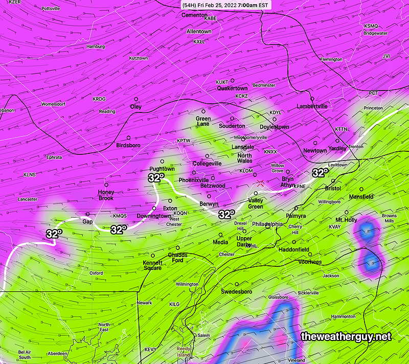
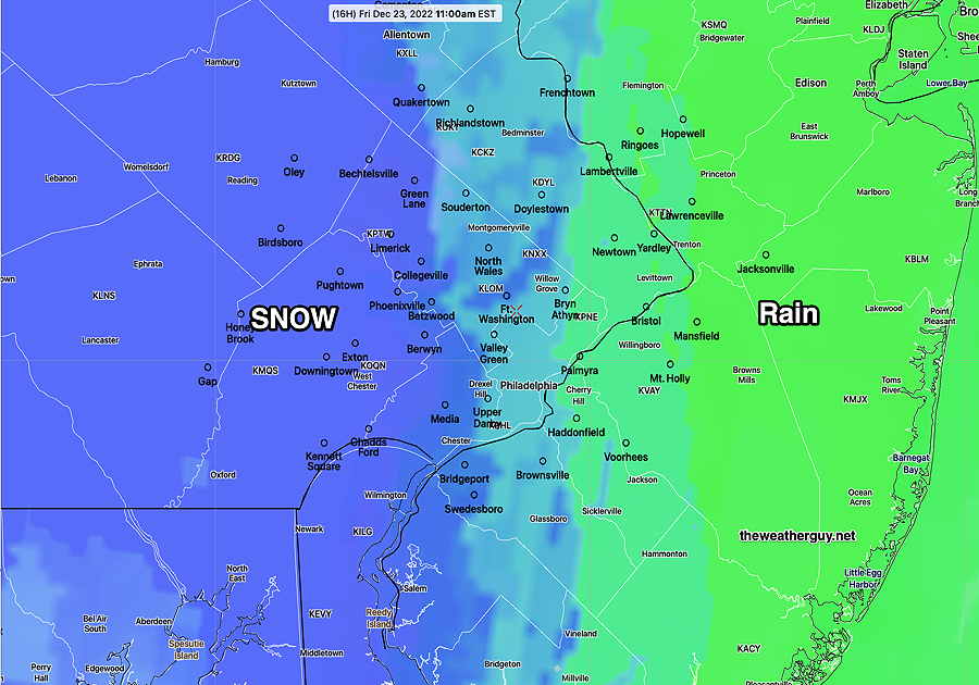
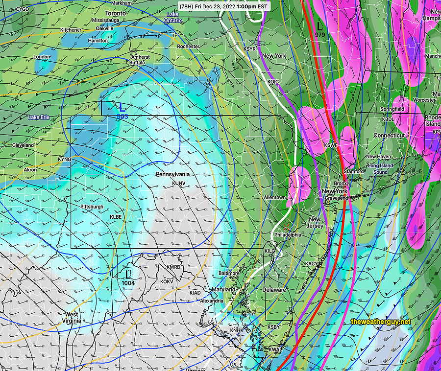
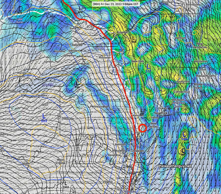
Update Fri 12/23 @ 10:15 AM — Additional rain now falling as the front moves in at 10 AM.

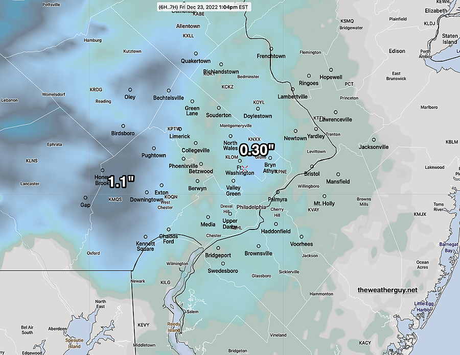
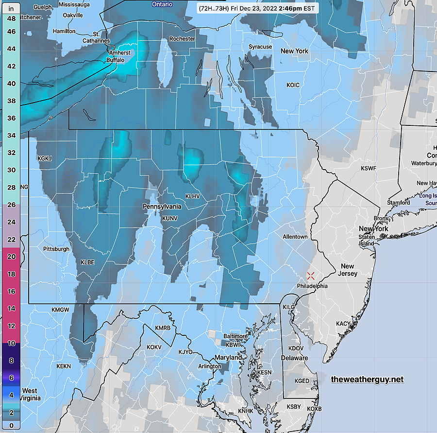
Storm rainfall measurements via MRMS through 9 AM—

MRMS calculated rainfall at 9AM for the previous 24 hours. Contours are mm. 25.4 mm= 1 inch (Click on image for a larger view.)

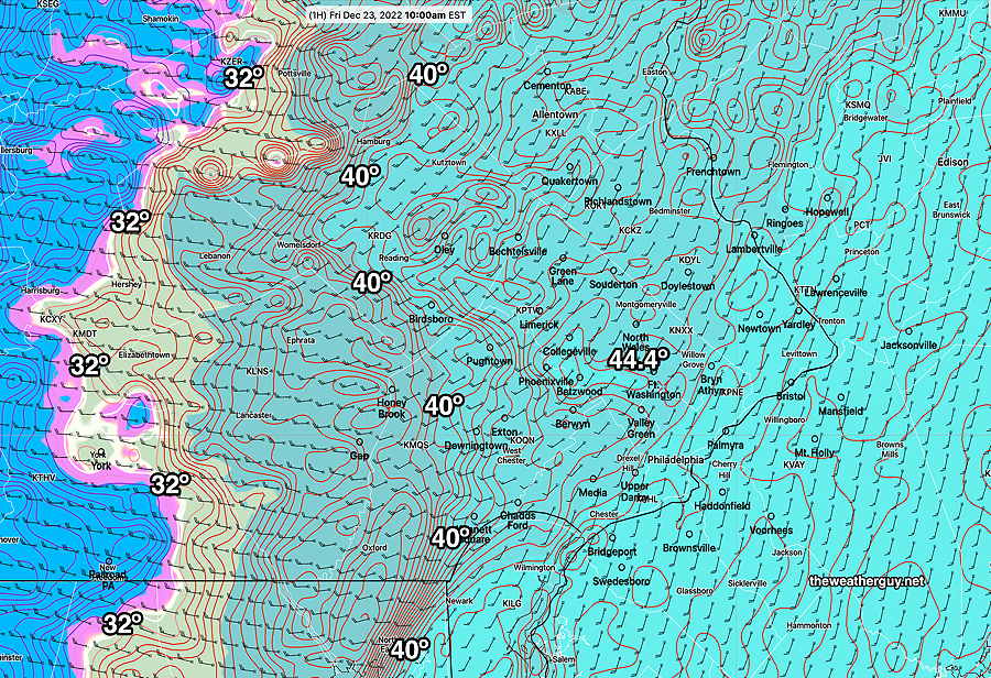
Current Temperatures at 10 AM—
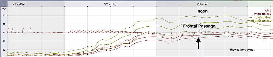
RTMA temperatures at 10AM Surface Cold Front is moving through Downingtown and Birdsboro (Click on image for a larger view.)

Cold Front Passage

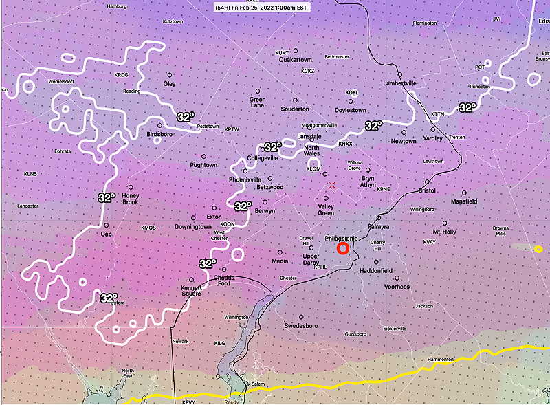
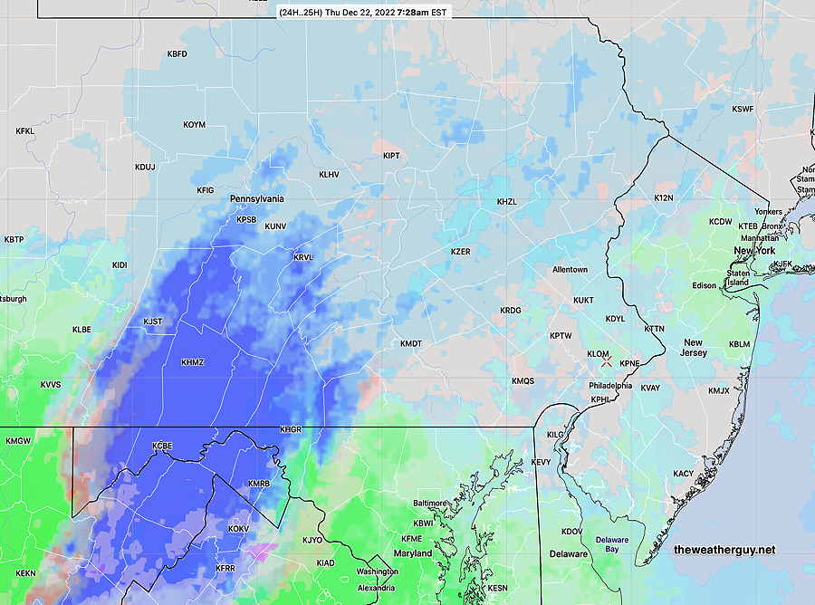
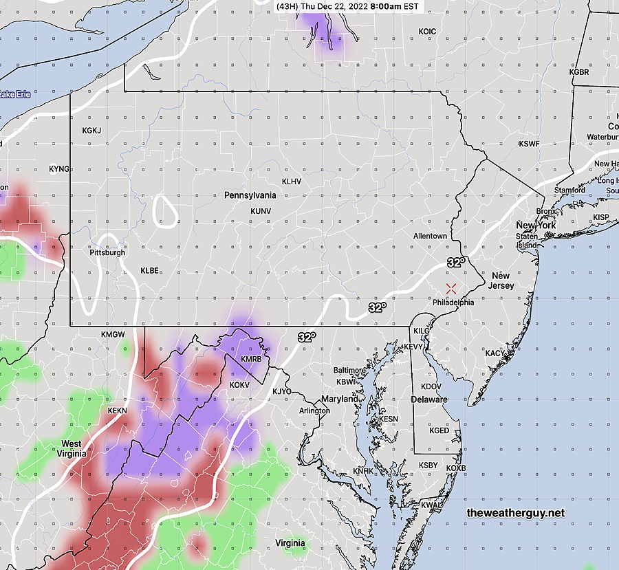
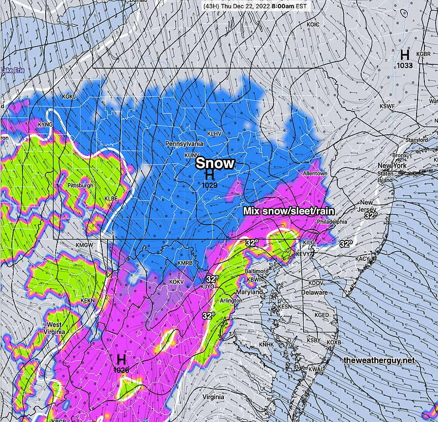
Update Thu 12/22 @ 9:47 PM — Latest NBM (00z) shows the rain to snow transition in the city about 11 AM.

00z NBM shows rain to snow transition at 11 AM. A very light coating of snow possible in some areas. (Click on image for a larger view.)

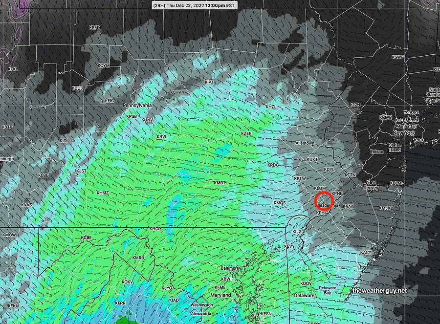
Some breaks in the clouds expected mid to late afternoon.

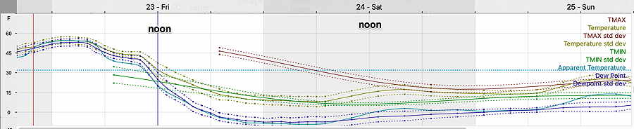
Temperatures drop from 58º to 32º by noon and into the 20s by afternoon—

00z NBM meteogram for Blue Bell PA (temperature and dew point with standard deviations) (Click on image for a larger view.)

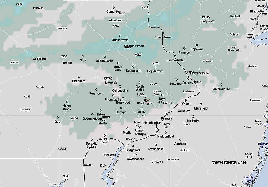
Areas that may see a light coating (less than 0.3 inches) —

CMC HRDPS snow totals (Click on image for a larger view.)

Storm Update

UpdateThu 12/22 6:31 PM — Forecast essentially unchanged. Cold front moves through as early as 9 AM according to latest GFS. Highest winds after midnight and just ahead of the frontal passage.


Update Thu 12/22 @ 11:36 AM — Latest 12z GFS available. GFS has closer to 1.5 inches of rain instead of the higher totals posted from the HREF. Probably somewhere in between these two.

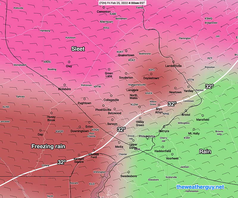
The GFS also has the cold front moving through earlier, about 9 AM at Blue Bell and the changeover to snow squalls/flurries. The GFS has a slight coating of snow in some northwest suburbs, but within the range of model noise.


Storm Update

Update Thu 12/22 @ 10:33 AM — This morning’s models are coming in. General forecast from yesterday still holds.

Here’s some changes with the 12z models—

  • Rainfall has increased and will total from 2 to 2.5 inches according to the HREF!
  • Highest winds and wind gusts after midnight tonight and especially during Friday morning.
  • Changeover to snow squalls and flurries may occur earlier, from west to east, from 9 AM to 11 AM.
  • The latest NBM has little to no accumulation, even in western suburbs.

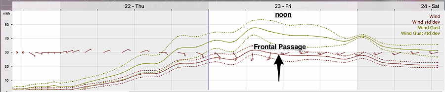
Wind Meteogram for Blue Bell PA

Today’s 13z NBM Wind Meteogram for location Blue Bell PA (Click on image for a larger view.)


Forecast Update

Update Wed 12/21 10:56 PM — No change in the forecast summary from this afternoon below. (The NBM joins the HRRR with an 11 AM start tomorrow.)


Current Storm Status on Wed Evening

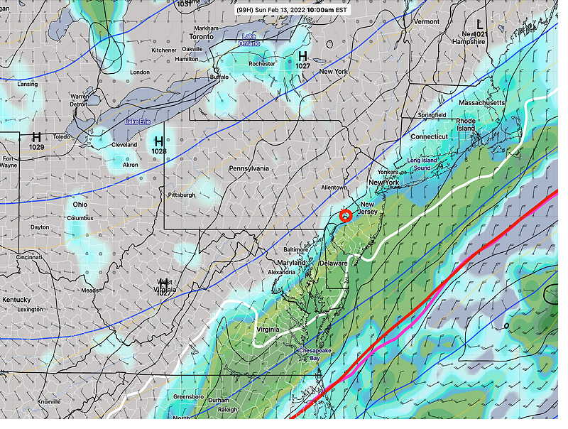
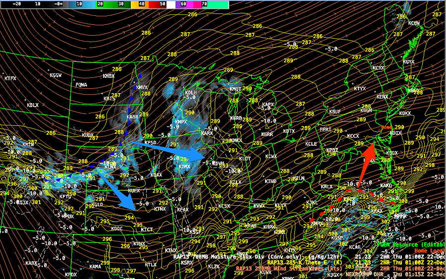
Update Wed 12/21 @ 8:25 PM — The pieces are coming together for the forecast. So what does it all look like on satellite and radar?

Water vapor image (at this specific wavelength-) shows the mid-atmosphere jet stream components—

Water Vapor at 8 PM Wednesday shows the subtropical jet bringing abundant moisture from the south. The main energy for the storm is just north of this image approaching Vancouver. This jet stream has winds of 200 mph and incredibly will be here on Friday.(Click on image for a larger view.)

Here’s the current composite radar—

Radar showing rain associated with advancing warm front from the south (red). This will move over us Thursday bringing heavy rain. Cold front well ahead of jet flow (blue) will move through here on Friday. (Yellow lines are Theta -E contours from the RAP model and clearly show the current position of the warm front. (red) (Click on image for a larger view.)

Update on Thursday -Friday Storm

Update Wed 12/21 @ 4:50 PM — This afternoon’s models just becoming available. Not much change from the previous two updates and a generally good consensus among the models. Here’s the current summary:

  • Rain starts in earnest between 11 AM Thursday, (HRRR model) and 2 PM (NBM model) although some light sprinkles can’t be ruled out as early as 7 AM.
  • Precip no longer expected to start as a snow mix here. Just rain.
  • Heaviest rain: late evening Thursday and Thursday night and also a burst of heavy rain as the front moves through Friday morning.
  • Rainfall will be heavy: 2-2.5 inches total rainfall
  • Cold front comes through Friday as early as 10 AM (HRRR) or 11 AM (NBM) with heavy rain and rapid drop in temperatures. At or below freezing by noon.
  • Wind gusts in the 45 mph range, possibly 50 mph after midnight Thursday and especially with the frontal passage Friday morning.
  • With the frontal passage, rain changes to snow showers between 11 AM and noon Friday.
  • No accumulation in the immediate PHL area. A thin coating possible northwestern Montgomery/Bucks/Chester counties.

More updates and fine-tuning as necessary. Stay tuned.


Update on Thursday -Friday Storm

Update Wed 12/21 @ 11:06 AM — Quick update. Latest GFS just became available. Rain moves in earlier, about 11 AM Thursday.

Friday: The front moves through about one hour earlier on Friday: 10 AM (Blue Bell PA) . Highest winds at that time. Change to snow squalls/flurries by 11 AM

Updates later this afternoon.


Update on Thursday- Friday Storm

Update Wed 12/21 @ 9:06 AM — After review last night’s models, I’m going to lean on the new NBM model (version 4.1) just released last week. Using this morning’s 12z run just available.

Thursday: While some sprinkles and even snow flurries will move in as early as 7 or 8 AM, the NBM shows accumulating rain moving in late morning on Thursday

Early Thursday morning—

Today’s 12z NBM 4.1 model Precipitation type at 7:30 AM (Click on image for a larger view.)

The rain moves in late Thursday morning and early afternoon—

NBM accumulating rain at 12 noon Thursday. Just starting and very light here. (Click on image for a larger view.)

Heavy rain Thursday late afternoon through night.

For Friday, the front is moving through just a bit earlier, about 11 AM. Wind gusts 40-50 mph expected.

12z NBM 4.1 meteogram for Blue Bell PA (wind and wind gusts with standard deviations) (Click on image for a larger view.)

A rapid mix to snow squalls and flurries. Here’s the NBM PTYPE—

NBM (12z) PTYPE at 11 AM Friday. (Click on image for a larger view.)

A coating or dusting possible by late afternoon Friday, but probability is is only 40% for Blue Bell.

Check back later for updates.


Differences in the Thursday Start Time

Update Tue 12/20 @ 9:03 PM — Latest NBM (00z) just available shows a light spotty mix at 8 AM Thursday. All to rain by 9 AM.

NBM version 4.1 (new model version) with improved PTYPE shows a spotty mix of very light rain and snow at 8 AM Thursday. (Click on image for a larger view.)

Update Tue 12/20 @ 8:26 PM — There are large differences in the precipitation start time on Thursday.

The GFS shows the precipitation not arriving here until about 2 PM Thursday.

The GFS at 8 AM Thursday shows precip well to our southwest—

GFS forecast (PTYPE) 8 AM Thursday Precip is well south of our area. (Click on image for a larger view.)

Several of this afternoon’s higher resolution models show light precipitation starting in the morning. The NBM is in this camp.

The Canadian RGEM even has some very light snow or frozen mix on the onset early Thursday morning.

The Canadian RGEM forecast for 8 AM Thursday morning (below) can’t be disregarded and seems to be supported by the latest ECMWF just available —

RGEM at 8AM Thursday. Last winter, the RGEM was remarkably good with Precip Types. Be advised that the RGEM PTYPE graphics always suggest much more precip than actually falls. (Click on image for a larger view.)

Of course it quickly changes to all rain on Thursday.


Thursday to Friday Storm Update

Update Tue 12/20 @ 5:41 PM — (added NBM snow accumulation below)

The latest models have stayed with the earlier timing of the storm and the cold front passage.

Thursday: This afternoon’s HRRR suggests that light rain moves in during the morning hours Thursday with rain becoming heavier about 2 PM. (The latest ECMWF and NBM have the rain moving in by late morning Thursday.)

Rain becomes increasingly heavy later Thursday and Thursday night. Winds increase after midnight Thursday. 1-2 inches of rain expected.

Friday: Here’s the latest NBM wind meteogram for Wings Field, Blue Bell showing wind gusts 45-50 mph from 6 AM to 6 PM Friday —

Today’s 19z NBM meteogram for Blue Bell PA. Frontal passage between 11 AM and 1 PM Friday. Wind gusts 45-50 mph! (Click on image for a larger view.)

I don’t see any snow squalls in any model’s forecast PTYPE, but the ECMWF has all three critical thickness lines east of us by 1 PM with some precip to their west. It could be the atmosphere dries out rapidly with the front, but I wouldn’t be surprised to see some non-accumulating snow squalls. (Hold your horses…latest GFS DOES SHOW SNOW SQUALLS)

12z ECMWF forecast for 1 PM Friday. The violet, magenta and red critical thickness contours are all east of us. Any precip will fall as snow even if temps haven’t fallen to 32º at the surface. (Click on image for a larger view.)

Latest GFS Just Available

Today’s 18z GFS shows PTYPE snow following surface 32º passage (white line) at 2 PM Friday (Click on image for a larger view.)

Stay tuned.

NBM snow accumulation by Friday evening—

19z NBM snowfall by Friday afternoon. Far northern and western suburbs may have a residual dusting of snow. (Click on image for a larger view.)

Update Tue 12/20 8:44 AM — A brief update with the current trends for the storm. The cold front continues to come through earlier and faster on Friday. The dry slot forecast by last night’s NAM has disappeared with its early morning 06z forecast.

The actual cold front moves through about noon to 1 PM Friday with thunderstorms and high wind gusts, possibly followed by plummeting temperatures.

Last night’s ECMWF suggests a quick period of non-accumulating snow showers/squalls following the frontal passage.

Clearing skies mid to afternoon on Friday. Very windy.

Updates later.


Update Mon 12/19 11:00 PM — Tonight’s NAM forecast range extends to 7 AM Friday.
Tonight’s NAM suggests that the heavy rain Thursday night departs early with a possible dry slot Friday morning. The sharp cold front comes through in the early afternoon with high winds perhaps some thunderstorms, another brief period of rain, followed by plummeting temperatures.


Storm Exits earlier on Friday

Update Mon 12/19 @ 7:59 PM — This afternoon’s models are leaning towards faster storm movement and an earlier cold front passage on Friday. (Previous models showed the front moving through late afternoon to evening.)

The NAEFS and GFS shows the front moving through about 12 PM to 1 PM Friday with the rain diminishing early to mid afternoon Friday. Temperatures start to drop with the frontal passage. High winds expected with the frontal passage.

Today’s 18z GFS simulated radar shows the front has moved through at 1 PM Friday. (Click on image for a larger view.)


Posted Mon 5:10 PM —

The big weather story for this week is the huge storm expected set up near the Great Lakes. For several days last week, it looked like we might have quite the snowstorm here; so much so that I thought it was prudent to set up a separate Winter Storm page.

Over the weekend, things have changed dramatically and a separate coastal storm is not expected to form with this system. A deep upper low pressure system will spawn a surface low west of us. Virtually no snow is currently forecast in our area by any model from this storm. Indeed, temperatures will rise into the 50s before falling rapidly below freezing Friday evening and night.

Nonetheless this will be a monster of a storm . Central pressures are forecast to rival recent hurricanes here. Heavy rain and high winds are expected.

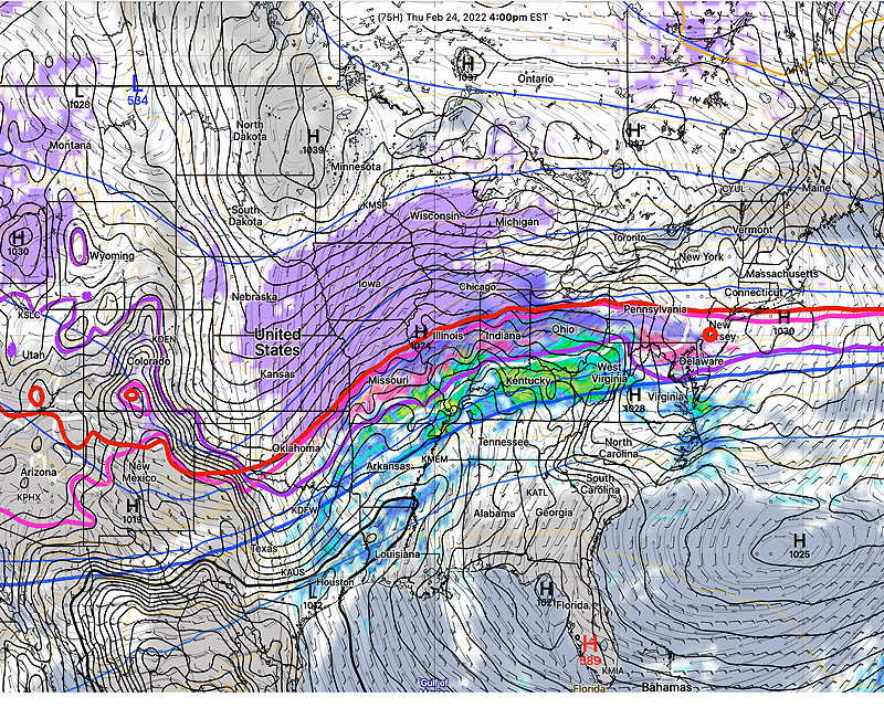
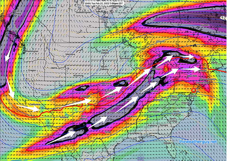
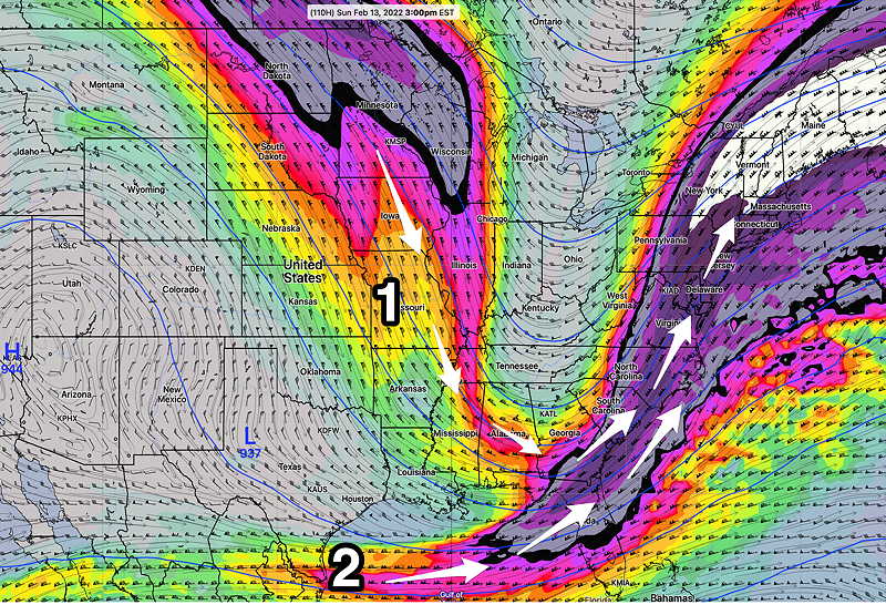
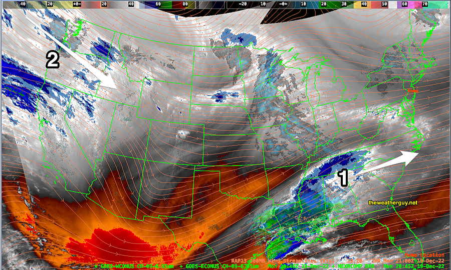
The impulse that will set off the large storm is not yet over the continental US. Leading jet flow energy is becoming visible below—

Water Vapor Image (Satellite) with RAP model 300 mb wind streamlines (orange lines) Storm (1) heads south of us over the next day or so. The leading edge of the impulsed that will form the huge storm for Thursday and Friday is just becoming visible (2) The main energy is over the Pacific ocean. (Click on image for a larger view.)

Currently rain from this storm is expected to move in Thursday afternoon and heavy rain will exit late Friday afternoon or early evening. Stay tuned.

THIS WEEK’S WEATHER

MIXED SLEET/FREEZING RAIN THURSDAY NIGHT CHANGING TO ALL RAIN BY MORNING

Fri 10:05 AM Forecast Review — So, we had even more ice accumulation than I would have guessed and temperatures did fall at or below freezing well into NJ, as forecast by last night’s NAM-NEST and HRRR.  The URMA shows temperatures at 2 AM—
URMA from 2 AM Friday morning  (URMA= “UnRestricted Mesoscale Analysis”)  The URMA represents actual temperatures and conditions and is used for model verification.  Since it represents corrected observations, the URMA is is released with a six hour delay to allow for corrected data input. (Click on image for a larger view.)

While the changeover to rain occurred, there was continued ice accretion past the rise in air temperatures above 32º.   Most of the models over-predicted the rate of temperature rise.  The major global models (GFS, ECMWF) never showed the temperatures drops into NJ.