MONDAY’S SNOW TO RAIN

Mon 08:32 PM Forecast Review —We had more snow than forecast.  The models (with the exception of the Canadian GEM model) underestimated the QPF and didn’t fully take into account the cold upper level atmospheric temperatures, which resulted in more snow and less rain. The NAM erroneously hastened the transition to rain, despite having the QPF somewhat in-range.   

The Canadian “Regional GEM” model is one model I always look at, but it it isn’t necessarily a model that is more often accurate.  I’ve seen it over-estimate snow totals many times.   Last night’s GEM had these higher snow totals, but as I said, “Not sure what to make of it” 

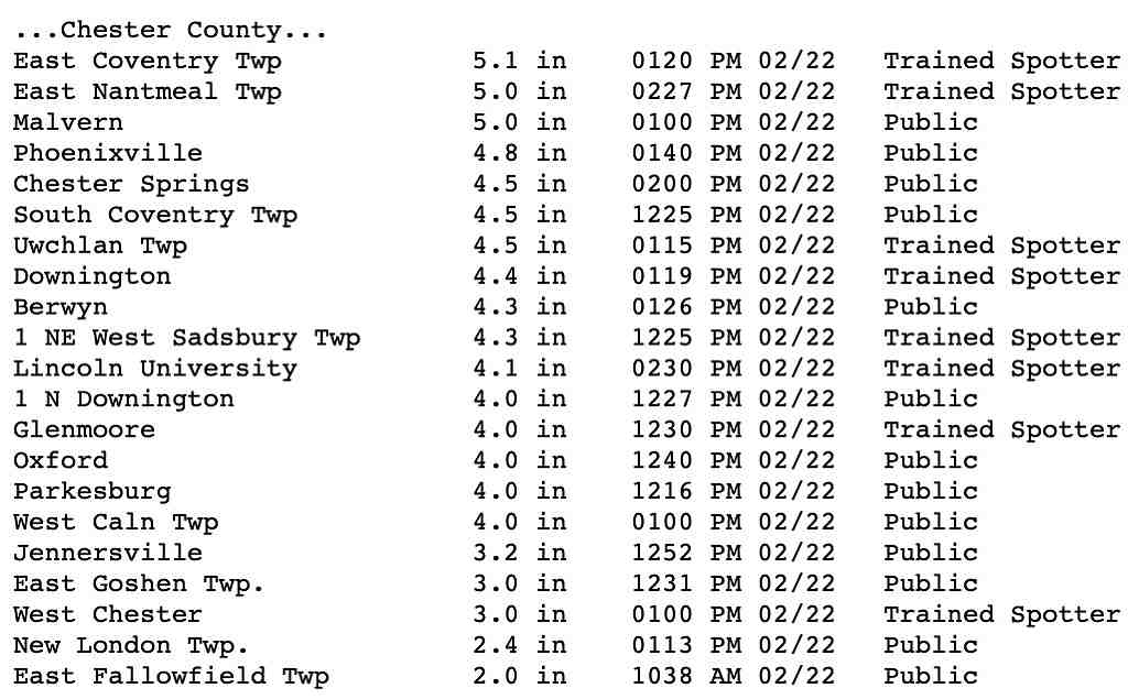
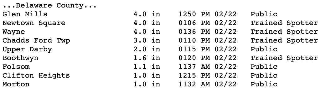
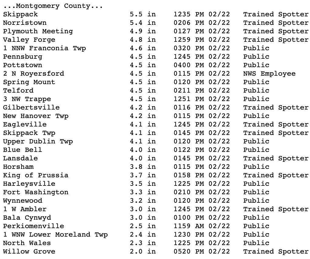
Here are the NWS official snow totals:
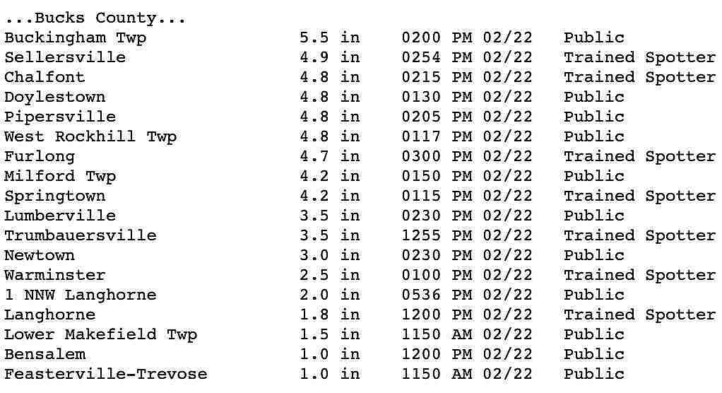
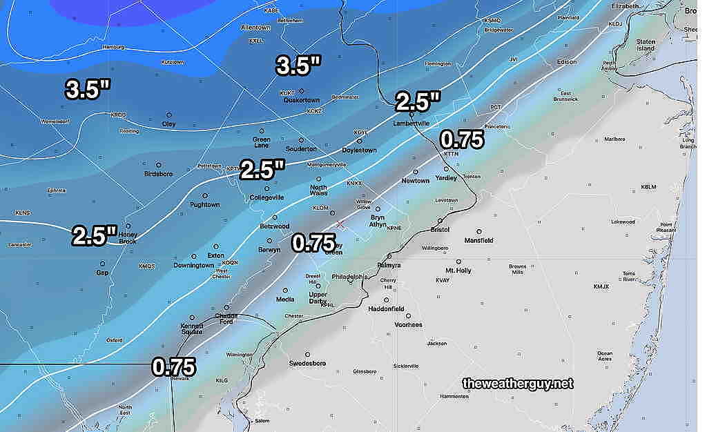
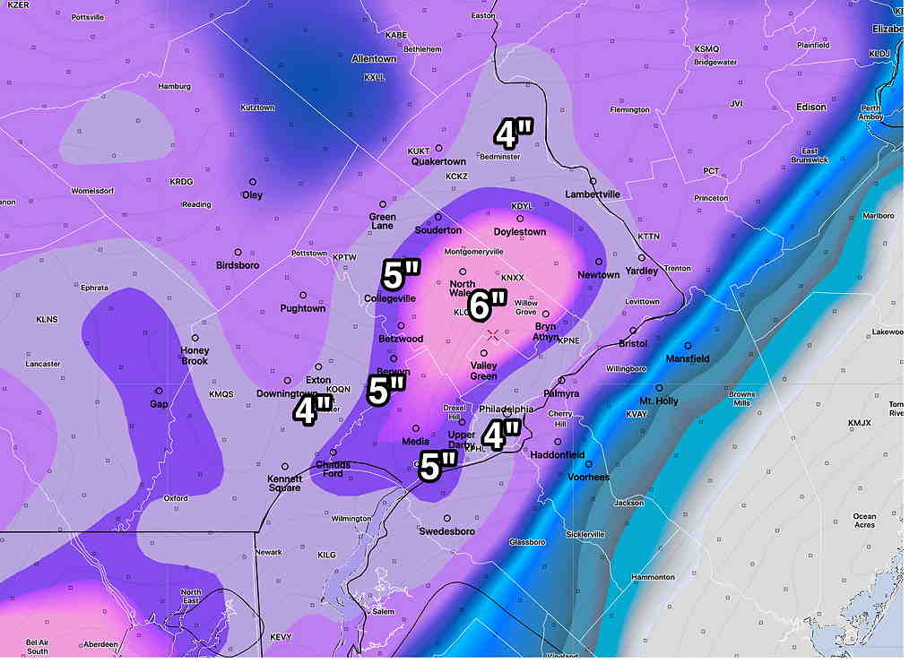
Here’s the graphic posted yesterday afternoon from the GEM model—

CMC GEM Model Snow totals 


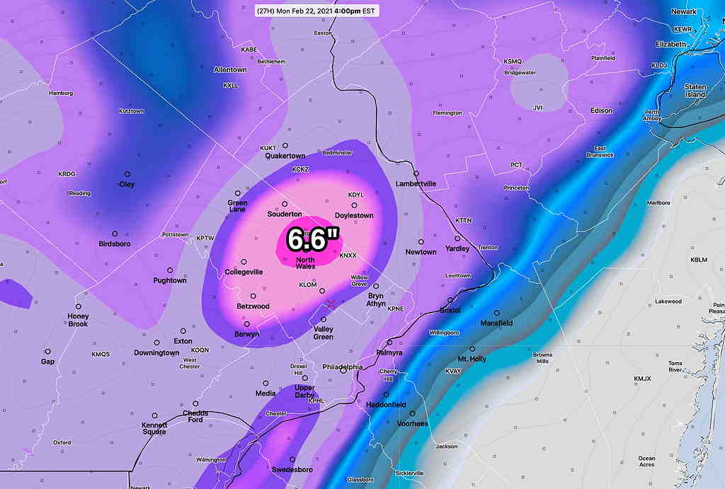
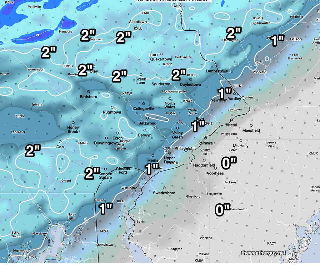
Here’s the GEM model that I looked at 11 PM last night but I didn’t know what to do with—

Last night’s Canadian GEM snow totals.  (The GEM shows snowfall as snowfall rate in Kg2/m2)  These numbers are correct.  The 4-5″ mentioned in last night’s  “update” was a quick, mental approximate conversion to inches of snow.)


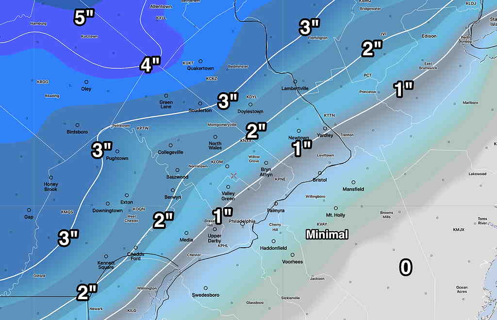
Update— Tonight’s Canadian model continues to forecast 4-5 inches of snow in central parts of Montgomery county.  Not sure what to make of it. 

Tonight’s latest models (HRRR, RAP, NAM)  shows the following changes— snow changeover a bit delayed northwest of the city, although snow totals are pretty much the same.  (It might be snowing an hour longer, but it will be increasingly difficult for accumulating snow.)

Dark, paved roadway surfaces will likely see less accumulation than grassy surfaces.

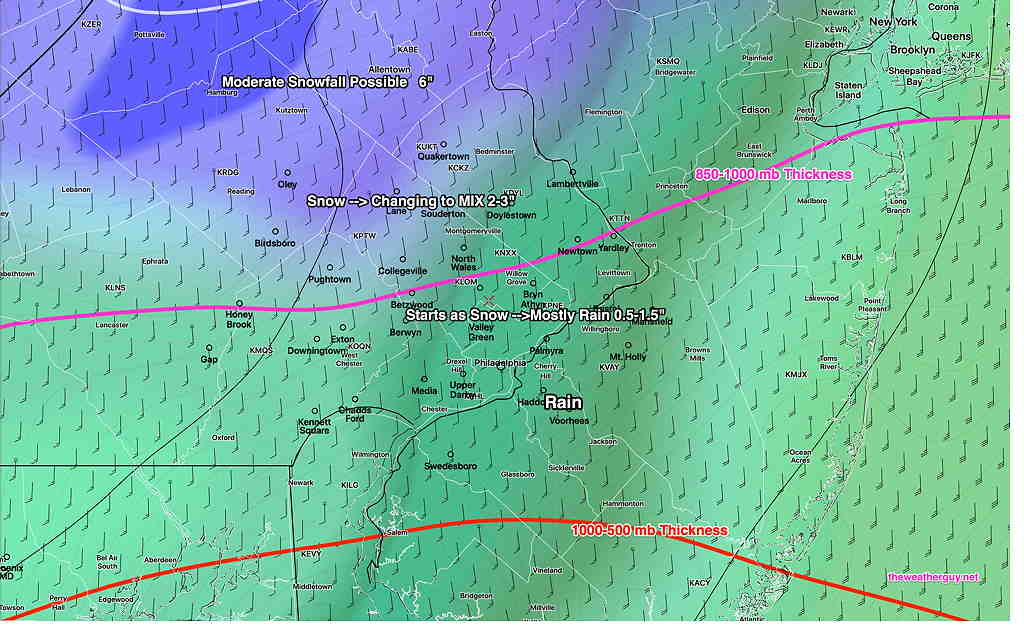
Snow starts about 9-11 AM from west to east and changes to rain from southeast to northwest by 2 PM.    Precip ends 3-4 PM.

The differences with this storm and recent previous storms  were outlined in an earlier post:

  •  The models have been consistent with total water falling (QPF) will only be 0.3-0.4″ water equivalent or less in the immediate PHL area, in  contrast to much greater amounts in previous storms.
  • The thermal structure of this storm is vastly different.   This storm will have southerly winds at the surface and surface temperatures will be at or above freezing for most of the area once things get going.   (Previous storms had northeasterly or easterly winds at the surface.)
  • In contrast, upper air temperatures will be colder northwest of the city, supporting snow formation but the surface temperatures will go against accumulation.
  • We’re into the final part of February.  The solar angle is higher and “insolation” effects through clouds are more likely to interfere with and cause melting on dark asphalt road surfaces when the precip occurs during the daytime hours.

Things can be summarized with this graphic slide show:

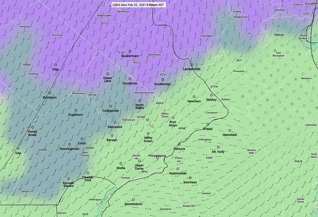
  • RAP model 10 AM Precipitation moves in
  • NAM model 1 PM Changeover northwest of the city. (note 32º surface temp white line)
  • RAP model Snow totals 4 PM


RAP model snowfall on grassy surfaces.  (Click on image for a larger view.)


MONDAY’S SNOW TO RAIN

Forecast Updated Sun 5:36 PM — This afternoon’s NAM has backed off on some of the precip and I think the earlier RAP model’s higher snow totals are too high. Either way, lower snow accumulations are expected on roads and dark asphalt. While the NAM still has about 0.4-0.5 water (QPF) falling, temperatures are above freezing by noon. It’s going to tough to accumulate much snow on paved surfaces.

This is a fast moving disturbance. Precip starts 9-11 AM and tapers off around 3 PM. Any snow comes as a heavy slug early.

  • NAM 11 AM showing surface freezing line (32º) white line already north of the city. Wet snow falling northwest of the city.
  • NAM 1 PM — much of the area has changed to rain

This afternoon’s (18z) HRRR is very similar to its model run earlier this morning, so here’s the same graphic posted earlier, which are the likely snow totals for Monday

High Resolution Rapid Refresh (HRRR) current likely snow totals.  (Click on image for a larger view.)


Just to share how crazy numerical weather prediction models can be, here’s the very latest Canadian GEM regional model—

CMC GEM Model Snow totals


Forecast Updated Sun 12:13 PM — This morning’s models have become available.  Here are the trends:  the QPF has increased with the NAM and RAP models have total water equivalents as high as 0.6″ water. 

The temperatures at the surface continue to be at or above freezing, but the upper atmosphere maintains its cold, allowing precip to fall as snow in areas north of the west and north.  Precip still starts 9-10 AM and tapers off around 3 PM. 

Latest RAP  (Rapid Refresh) Model—

Rapid Refresh (RAP) model snow totals by 3 PM Monday (Click on image for a larger view.)


Predominant Precip by 2 PM—

RAP Model 2 PM PTYPE  (green=rain) (violet=snow)  (Click on image for a larger view.)


from earlier Sunday morning..

Monday’s wintry weather is almost within a 24 hour range and it’s worth trying to take a stab at the snow totals.

As mentioned in my previous update, the trend has been for the precipitation to start from west to east about 9:00-11 AM Monday.   

This storm will be vastly different from the several previous  storms—

  •  The models have been consistent with total water falling (QPF) will only be 0.3″ water equivalent or less in the immediate PHL area, in  contrast to much greater amounts in previous storms.
  • The thermal structure of this storm is vastly different.   This storm will have southerly winds at the surface and surface temperatures will be at or above freezing for most of the area once things get going.   (Previous storms had northeasterly or easterly winds at the surface.)
  • In contrast, upper air temperatures will be colder northwest of the city, supporting snow formation but the surface temperatures will go against accumulation.
  • We’re into the final part of February.  The solar angle is higher and “insolation” effects through clouds are more likely to interfere with and cause melting on dark asphalt road surfaces when the precip occurs during the daytime hours.

Whatever starts as snow will mix with or change to rain,  as depicted by this graphic with snow totals, especially in the green shading and south of the magenta line—

Short Range Ensemble Forecast (SREF) precip with precip type.  Any area south of the magenta line (850-1000 mb thickness line) should have be a mix, mostly rain,  by 1 PM. The PTYPE predominant rain is shaded in green.    (Click on image for a larger view.)


The latest HRRR shows these snow totals before a mix and change to rain in most areas.  This only shows snow totals.   (Much of the area will eventually become mostly rain, as depicted in the SREF above) —

High Resolution Rapid Refresh (HRRR) snow totals before a change to rain.  These numbers will reduce after the change to rain where rain becomes the dominant precip type.  (Click on image for a larger view.)


The Model Blend (NBM) is similar to the above forecast, as is the German ICON model.


I’ll update this evening with the latest models.