
Forecast Updated Thu 7:38 AM — So, there’s a lot more snow out there than had been predicted. Last night’s update at 10:55 PM indicated the forecast might be in trouble when the GFS water QPF was 0.4” and the NAM was over 1.0”.
The QPF is looking closer to that predicted by last night’s NAM and RAP models. (I had panned the RAP forecast and when the low QPF GFS came out, I had subtracted from the HRRR instead moving towards the NAM. “Never ignore the NAM”.).
The precipitation has started earlier than most models had predicted. The cold temperatures has made the snow ratio closer to 1:15 instead of the usual 1:10 or so. So we have a trifecta of issues: timing, more QPF and a snow ratio that was too low.
The 4 AM RAP model has snow falling until 4 PM; the changeover to sleet is delayed. The new RAP, HRRR and NAM will be available soon. I’m going to go back and look at the 1AM models and see which, if any, got this right.
Forecast Updated Wed 10:55 PM — This is turning into a more uncertain forecast. The GFS just became available. Its precipitation axis is similar to the RAP below. Its QPF is similar to its runs from earlier today which is half of the latest NAM. In these situations an average of the NAM and GFS sometimes works. I’m going to continue with the HRRR forecast below but we may need to subtract an inch or so in the immediate Philadephia area.
Forecast Updated Wed 10:27 PM — After reviewing additional models (HIRESW, SREF) I think the HRRR below is probably the best snow forecast to hang one’s hat on. It captures many aspects of the NAM —

Snow starts about 6-7AM and whatever is falling in the afternoon tapers off beginning 3 PM. Additional light snow/flurries later and in the evening.
All-important is the GFS model. The GFS model becomes available about 10:43 PM. I’ll update after reviewing it.
Posted earlier Wednesday evening 9:29 PM…
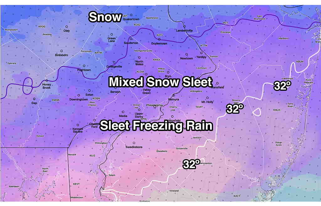
Despite the trend from earlier today for lower snow totals, the latest models have taken a major switch to a colder and snowier forecast.
The axis of heavier precipitation has shifted north and colder temperatures seem to assure that most areas in from around Philadelphia will have a significant snowfall. The models all seem to have a transition to sleet and freezing rain, but some are having it occur later in the afternoon (3 PM) instead of the previous 1PM changeover. QPF values from the NAM model have gone into the 0.75 – 1 inch of water range.
I’ll present the HRRR model graphics, since they capture the change to more snow, similar to the new NAM—
I’m not a big fan of the RAP (RAPid Refresh) but its physics are somewhat aligned with the GFS. The GFS comes out later tonight. Here’s the RAP model forecast. I think it’s forecasting too much snow.

Here’s the latest Model Blend (NBM 00z) model. I like the NBM. Yesterday, it was announced that there’s an error with some of its precipitation algorithms that will be corrected next month. The NBM blends many models. However, when there is a shift in the forecast, it can lag the trend. So I’m just presenting its precipitation type forecast.
Continued after 9:30 PM as updates above.