HEAVY RAIN EVENT WEDNESDAY NIGHT

Wed 05:43 PM Update — It’s not just snowstorm forecasts that change. It’s just more obvious when a snow forecast has gone astray with a 10:1 ratio making the error more obvious.   

This afternoon’s models have moved the heavy rain south and eastward into N.J.  Here’s the latest NAM-NEST model—

NAM NEST model accumulated precip  (Click on image for a larger view.)


Wed 08:40 AM Update — The models have moved the axis of heavy rain today and tonight  just to the south of the immediate PHL area.  Current RAP has the axis of heavy rain as shown—
RAP Precip forecast  (Click on image for a larger view.)

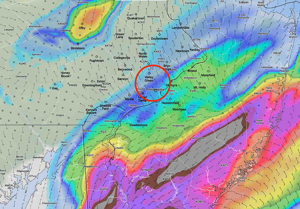
The ICON and early morning Canadian models have the axis even further to our south.     So there remains uncertainty about total rainfall  from PHL and north.   Likely closer to 0.8-1.0″ 

from last night…

The models have begun predicting an increasingly heavy rain event for Philadelphia, from Wednesday afternoon into daybreak Thursday. Rain starts about noon on Wednesday and tapers early Thursday morning. The heaviest rain will occur Wednesday evening, towards midnight.

Previous model runs had an axis of heavy rain to the south of our area, through southern Delaware.

Today’s model runs, specifically the the ICON model and the Canadian High Resolution model (HRDPS) have the axis of heavy rain through the Philadelphia area.

(The ICON model did particularly well predicting the heavy rain in advance of  last week’s storm.)

ICON Model (German) accumulated rain forecast. (Click on image for a larger view.)

This afternoon’s HRRR and NAM models are moving in the same direction with total rainfall in the 1-1.8″ range for Philadelphia.

NAM accumulated rain forecast for Philadelphia by Thursday morning. (Click on image for a larger view.)

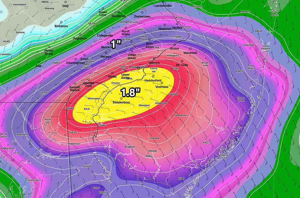
The heaviest rain will occur Wednesday evening, towards midnight. There remains some spread as to where the rain axis will be heaviest. The NAM is slightly south of Philadelphia, while the Canadian models are slightly north.

This event is still more than 24 hours away, but the trend towards heavy rain has been consistent.

ANOTHER BRIEF RETURN TO WINTER

A low pressure system will move in Wednesday afternoon with moderate rain (~1 “) and a  strong cold front will move through later Wednesday night with the jet stream plunging southward from a push of cold air—

Canadian GEM Regional model forecast 10 PM Thursday.  Red line is the 1000-500mb thickness line,  a rough approximation for the jet position and often considered the ‘rain-snow line’.  (Click on image for a larger view.)


This very strong cold front may bring some ‘interesting weather’ as it moves through and I’ll be keeping an eye on it.

Much colder temperatures later Thursday through early Saturday.  We may even see some snow flurries Thursday nightCold, windy conditions Thursday through Friday!   High temperatures in the low to mid 40s Friday and temps may fall into the upper 20s Friday night.   Still chilly on Saturday, although the afternoon should warm up a bit more.

Things  moderate further on Easter Sunday and next week looks milder and more tranquil.