WEEKEND WEATHER FORECAST

#weather #paweather #wx #pawx #philadelphia

Forecast Update

Update Sat 03/25 @ 4:38 PM — The models have backed away from thunderstorms developing in the immediate PHL area. The area of development may be South Jersey, about 10 PM

This afternoon’s 18z HRRR shows thunderstorms developing about 10-11 PM in South Jersey. Little to no activity in the immediate PHL area. (Click on image for a larger view.)

Sunday looks suuny. A bit windy. Temps upper 50s to near 60.


Update Sat 03/25 @ 10:33 AM — There have been some changes in the forecast.

The rain will be moving in over the next hour or so. Rain ends about 5-6 PM. Total rainfall about 0.2-0.5 inches. A second batch of rain and thunderstorms about 9-11:30 PM

Here’s the current water vapor image. The first boxed area (1) is the area of upward motion bringing the rain in the next few hours. The second boxed area (2) may bring some thunderstorms between 9-11:30 PM, (maybe missing the immediate PHL area, maybe not.) Some model uncertainty in the placement of the second batch of rain/thunderstorms.


Update Fri 3/24 11:20 PM — Tonight’s models show breaks in the rain Saturday with total rainfall on the light side. The warm front gets further north and temperatures rise to upper 50s late afternoon.


Update Fri 03/24 @ 7:59 PM — Minor update to include the mention of thunderstorms mid-day with the rain. The latest models have very high levels of helicity and vertical shear, greater than that which spawned Thursday evening’s surprise thunderstorms . Nothing severe expected because CAPE values are expected to be low.


The cold front that moved through Friday night has stalled to our south and will try to return as a warm front later Friday night as a cold front moves in from the northwest later on Saturday.

It appears that the warm front won’t make it north of our area, as low pressure is expected to form near the Delmarva coast.

Water Vapor image at 4 PM shows large storm in Mississippi Valley and significant water vapor flow into our area. This will affect us on Saturday. (Click on image for a larger view.)

The warm front, the low pressure system and the cold front will result in periods of rain for much of Saturday. Thunderstorms appear possible Saturday evening, especially north and west of the city.

Saturday

Cloudy with rain becoming heavier late morning and continuing on and off during the day. Some thunderstorms mixed in with the rain possible mid day. Becoming very WINDY and gusty. Scattered thunderstorms again possible between 6 and 10 PM, mostly northwest of the city. Clearing after midnight.

High temperature 53.5º sd 2.4º ( NBM model location – Blue Bell, PA)

Sunday

Sunny and mild. Still quite windy.

High temperature 60.3º sd 1.7º ( NBM model location Blue Bell, PA)

Winds
Strong wind gusts about noon-2 PM Saturday. Large wind shift about 10 PM signifies cold front passage. (Click on image for a larger view.)

THIS WEEK’S WEATHER

#weather #paweather #wx #pawx #philadelphia

Friday Forecast Update

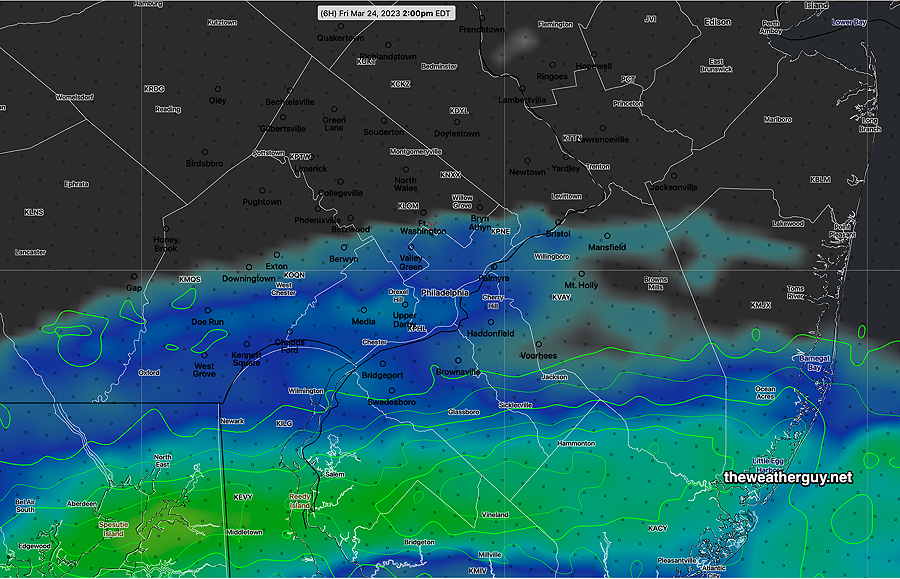
Update Fri 03/24 @ 10:38 AM — The showers associated with the cold front have lingered further north than forecast last night. They will likely linger into the afternoon (2-3 PM) in contrast to the 11 AM time frame forecast yesterday. Cloudiness will remain through the afternoon.

This morning’s 12z HIRESW shows lingering very light showers possible at 2 PM. This moves south of the city by 3 PM. (Click on image for a larger view.)

Thu 9:44 PM Regarding tonight’s storms Folks, I was asleep at the wheel regarding tonight’s substantial thunderstorms. I was focused on Friday and I hadn’t even looked at tonight’s forecast in detail.

There goes my second career!

Anyhow, now that I’ve looked at the models from this afternoon again, it should have been pretty clear that thunderstorms were likely, even some heavy storms. Helicity values were very high (~ 700 m2/s2) and shear values were very high (approached 40).

(During last summer’s dry period, we didn’t even come close to values like this to get a thunderstorm.)

Strangely, the NBM gave a only 3% chance of thunderstorms tonight, probably because CAPE values were only in the 300 J/Kg range.

It shows you can get some strong storms with very little CAPE, if you have the other ingredients.

Friday Forecast Update

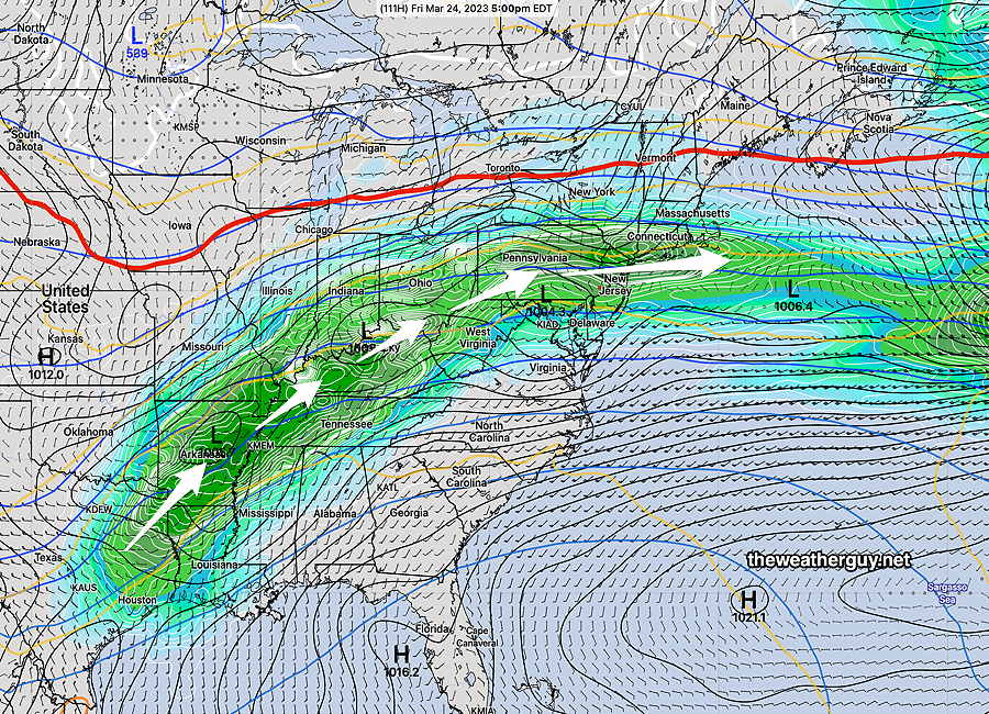
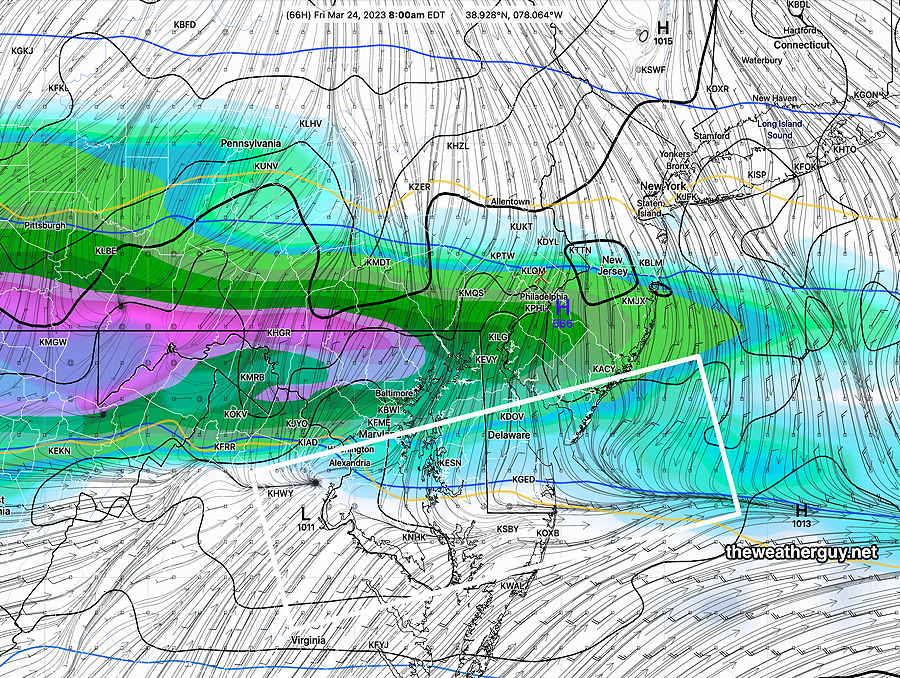
Update Thu 03/23 @ 5:24 PM — Today’s models continue with the forecast of a cold front dropping through our area Thursday night and stalling as it moves south of Philadelphia. Waves of low pressure will ride along this front on Friday. It will be quite chilly on Friday, as temperatures will be in the mid to upper 40s.

The rain, for much of the day Friday, will affect mostly southern areas, although during the morning (before 11 AM or so) , some light rain may spill northward as the disturbance moves by to the east.

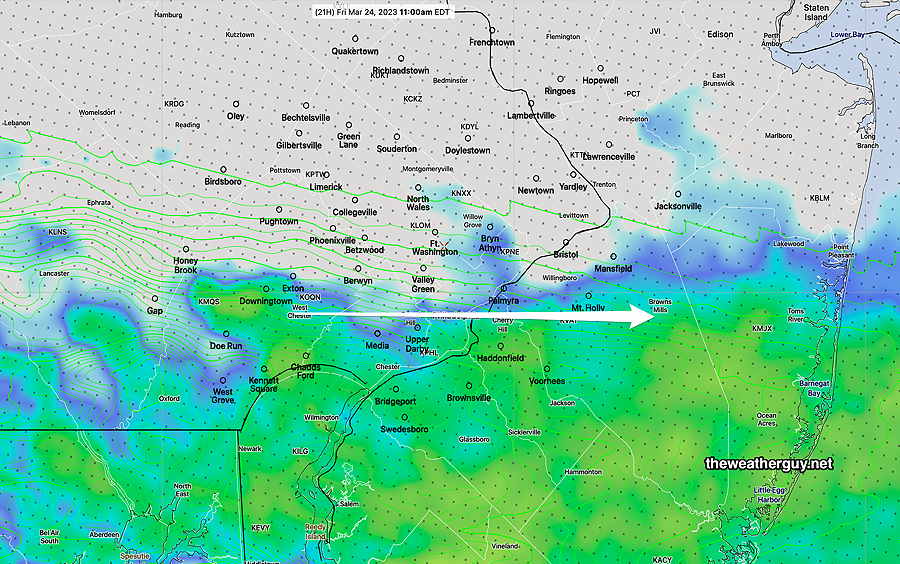
The latest NAM-NEST below captures the forecast scenario for Friday and is very much in-line with yesterday’s HRDPS and the latest NBM—

Today’s 18z NAM-NEST simulated radar forecast at 11 AM shows where most of the rain will be on Friday, although it will be a bit further north during the mid-morning hours. (Click on image for a larger view.)

The front will move back as a warm front on Saturday before another cold front moves through.

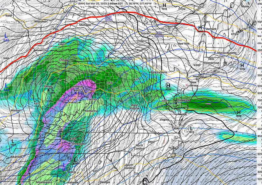
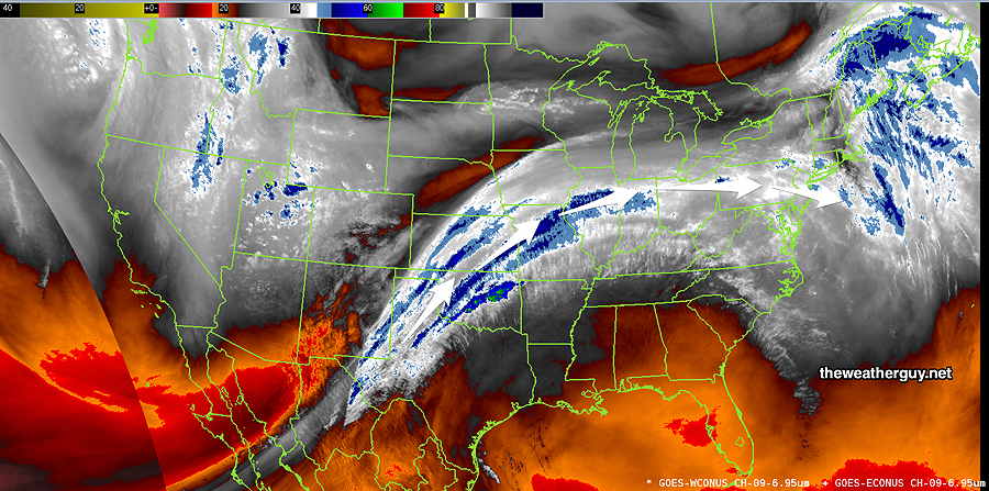
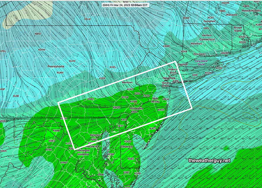
The stream of moisture will continue through parts of Saturday. The overall flow is captured by this water vapor image—

Today’s water vapor image, showing the flow of moisture into our area through Saturday.

A mix of sun, clouds and showers expected on Saturday. Details tomorrow.


Thursday – Friday Forecast

Update Wed 03/22 @ 7:59 PM — The showers mentioned last night showed on radar at 8AM Wednesday but evaporated before reaching the ground.

For Thursday, a mid-level disturbance will bring some rain Thursday morning but there should be some partial clearing Thursday afternoon, after 1 PM. Temperatures may reach 70º (Canadian Model) or 68º (NBM)

As mentioned last night, cold front moves through Thursday night with more showers. The front slows down and stalls just to our south. Rain will move along the front.

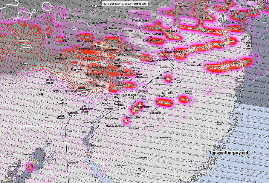
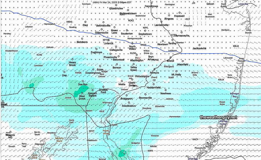
Depending upon the position of the front, Friday may just be cloudy, or may have considerable shower activity. The Canadian high resolution model (HRDPS) has the northern extent of the rain just reaching areas of Montgomery county—

Canadian HRDPS Precipitation Rate forecast at 1 PM Friday. (Click on image for a larger view.)

Too soon to be sure about the location of the showers on Friday.


Update Tue 3/21 11:24 PM —Tonight’s high resolution models show some showers early Wednesday morning with the warm front.


Previously Posted Tue 9:00 PM —

The incredible weather we’ve had for the past two days will decline from perfection from Wednesday through Saturday.

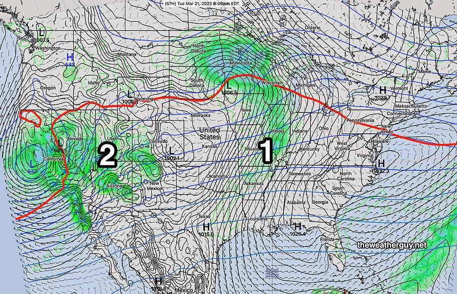
A warm front is approaching from the southwest as a major storm sets up in the middle of the country.

Wednesday will feature a mix of clouds and sun as a warm front moves through. Most of the cloudiness will lift in the afternoon, after the warm front passes to our north. Highs will again reach the low 60s.

Following the warm front passage Wednesday, things become a bit more uncertain, as a backdoor cold front will slowly move through late on Thursday night with light rain at times during the daytime.

On Thursday, despite the rain and considerable cloudiness, temperatures will approach 70°.

A back door cold front moves through Thursday night—

GFS shows temperatures (shading) and the winds shifting from southwesterly to northwesterly at midnight Thursday into Friday morning. (Click on image for a larger view.)

This front will set up somewhere in our region, slowly drifting southward as waves of low pressure move through our area on Friday—

GFS showing rain moving in during the day Friday Notice the white box area (wind direction change) is down past southern Delaware. (Click on image for a larger view.)

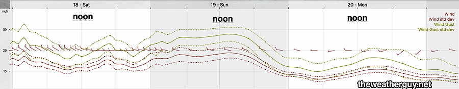
Saturday, another system in the Great Lakes will push a cold front through. More showers and windy conditions.

GFS Saturday 2 AM (Click on image for a larger view.)