THIS WEEK’S WEATHER

#weather #paweather #wx #pawx #philadelphia

Friday Forecast Update

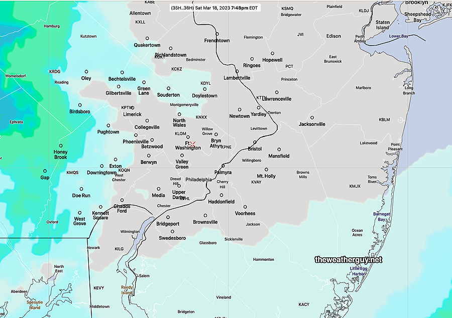
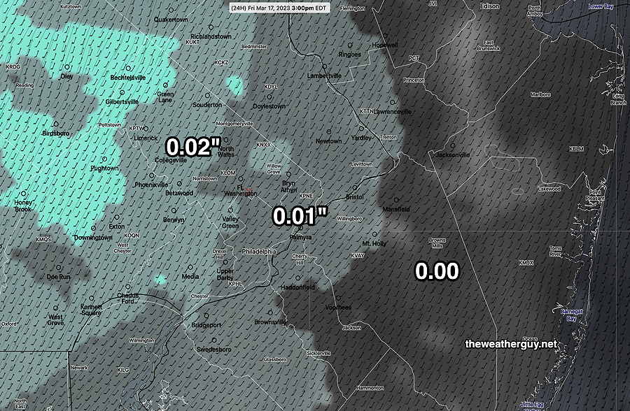
Update Fri 03/17 @ 9:45 AM — This morning’s NBM keeps measurable precipitation (< 0.01″) in the Philadelphia area to a minimum during the daytime today. This is in keeping with previous forecasts. High temp 62º-65º

The latest HRRR does have some showers moving in, but during the evening hours, 9-11 PM.

Here’s the NBM—

Latest 12z NBM forecast total measurable precipitation Friday and Friday night. (Click on image for a larger view.)

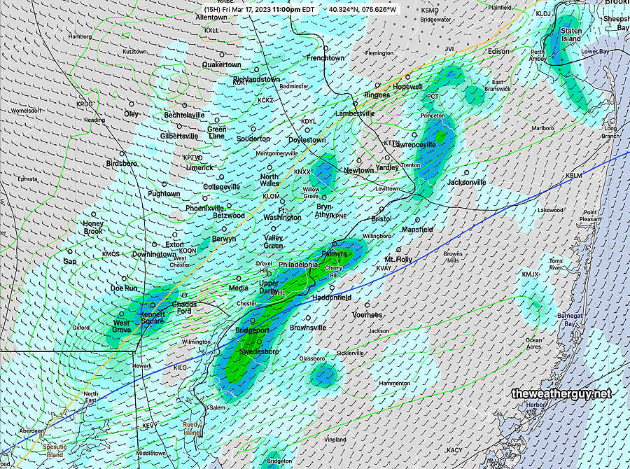
In contrast, the latest HRRR has showers moving through 9-11 PM tonight—

Today’s 12z HRRR forecast for 11 PM Friday night. (Click on image for a larger view.)

Friday Forecast Update

Update Thu 03/16 @ 5:09 PM — Yesterday’s forecast for Friday had the line of showers dissipating before reaching the immediate Philadelphia area.

Today’s model forecasts suggest the showers make it into Philadelphia with reduced intensity— light scattered showers mid afternoon and early evening.

Friday: Some clouds and sun before noon, then increasingly cloudy with occasional bright skies into mid afternoon. Light showers move in from the west. Since there’s a range of model forecasts, I’ll turn it over to the NBM to do the heavy lifting—

Today’s 19z NBM 1 hour accumulated rain forecast for 3 PM Friday. It should be noted that the showers will likely be more spotty than suggested by this graphic. (Click on image for a larger view.)

Thursday and Friday Forecast

Update Wed 03/15 @ 5:18 PM — We’ll have a bit of high cloudiness Thursday morning which will dissipate for sunshine the remainder of Thursday.

A warm front followed by a cold front expected to bring clouds Friday and mild temperatures. The latest models have little in the way of rain Friday and Friday night, as a cold front will have its energy move to our north while a secondary low develops and moves off to our south. Much of the rain misses us.

ECMWF shows much of the rain dissipating as it moves towards Philadelphia Friday and Friday night. Little in the way of rain here.

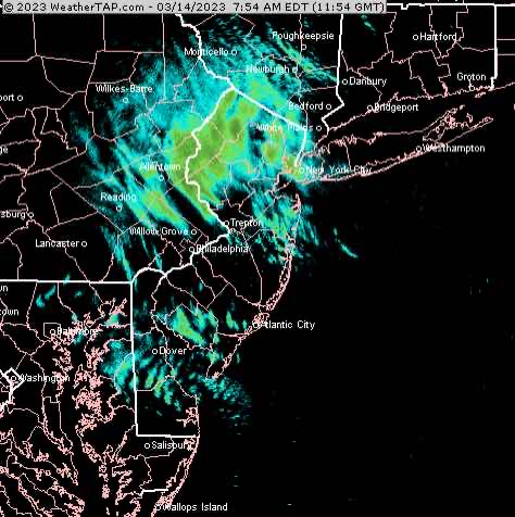
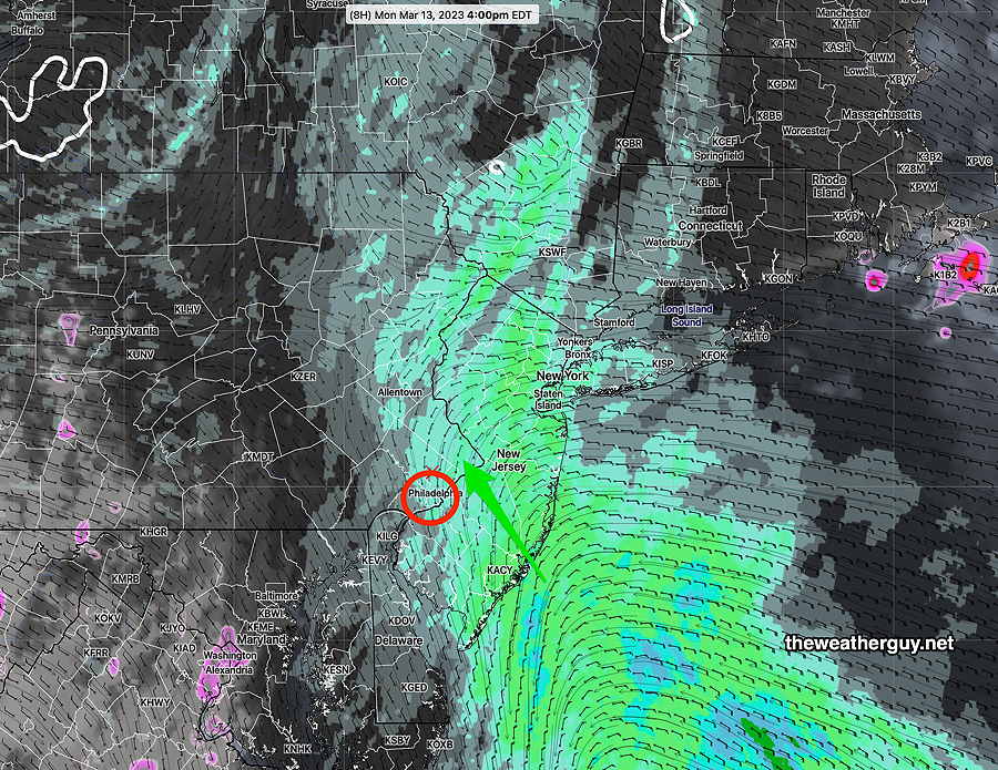
Previously Posted Tue 4:48 PM —

Wednesday Forecast

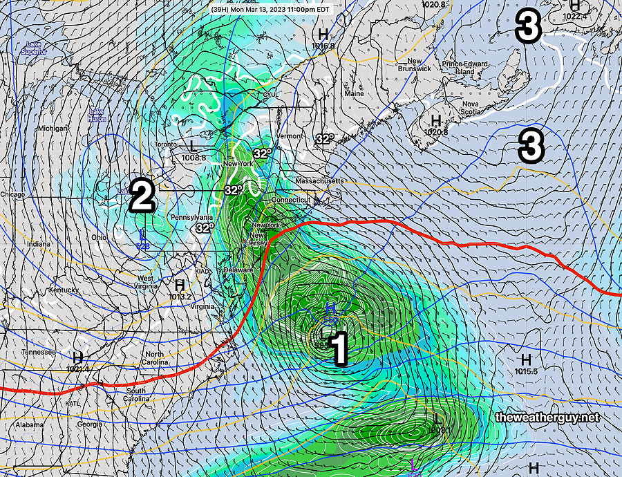
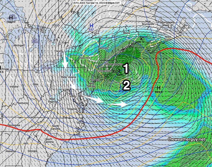
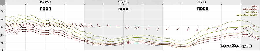
The snow showers and the winds did not disappoint today. I thought the models did pretty good with this storm.

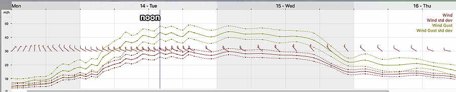
The cyclonic flow around the deep low off the New England coast will still be with us, as will the tight pressure gradient as high pressure builds in.

As a result, the winds on Wednesday will still be formidable and gusty, but should begin to subside Wednesday night.

Here’s the wind meteogram for Wings Field, Blue Bell for the next three days—

Today’s 19z NBM model Wind meteogram for location Blue Bell – Wings Field. Some wind gusts still in the 30-40+ mph range on Wednesday (Click on image for a larger view.)

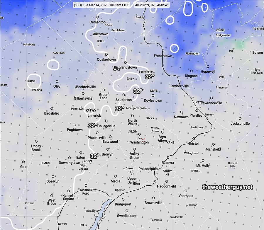
Wednesday— The models are predicting sunny skies after some very early morning cloudiness. Highs 47º-48º

Thursday– sunny and milder. High near 57º Some clouds move in late in the afternoon.

Friday— Cloudy mild. Increasing winds. High near 60º Rain moves in during the early to mid afternoon ahead of a cold front.


THIS WEEK’S WEATHER

#weather #paweather #wx #pawx #philadelphia

Update Tue 3/14 8:44 AM — Snow flurries/snow showers have developed, as predicted. Last night’s HRRR and RAP models have the likelihood of even greater snow shower coverage during the afternoon.

NEXRAD Radar at 7:54 AM today. Courtesy of WeatherTAP.com

Update Mon 3/13 7:20 PM — This afternoon’s models are predicting surface temperatures to drop to freezing just outside of the city Tuesday morning. There’s the chance of some icy conditions early that should dissipate by the mid morning in most areas.

Most of the precipitation still expected to be east of us, but wrap around moisture will cause snow showers during the day with high winds. Much of the snow shower activity may be later in the afternoon.

NBM temperatures and precipitation type at 7AM. Note the 32º line. The standard deviation is 1.6º meaning that there’s uncertainty where the freezing line is. It could be closer to the city, it could be further. Blue indicates increasing chance of snow showers. (Click on image for a larger view.)

Mon 03/13 @ 11:27 AM — Added wind meteogram below—

The NBM (which tends to be low with winds) is forecasting wind gusts in the 45-50 mph range for our area on Tuesday. (Click on image for a larger view.)

There has been an eastward trend to the storm track with the latest models. (Background on this storm can be found here.) This translates into lower total precipitation in our area to just 0.20 to 0.30 inches of precip (meaning rain or “snow water equivalent”.)

Here’s the latest NAM-NEST total precip forecast for this storm —

This morning’s 12z NAM-Nest shows the majority of the precip will be east of us and into New England. (Click on image for a larger view.)

With the reduction of total precipitation, the possibility of any accumulating snow here has been even further reduced to close to zero. The NAM-NEST shows almost nothing, the CMC HRDPS has a small accumulation near Doylestown.

For today, Monday, the rain doesn’t really get started here until 3-4 PM, moving in from the southeast.

The NBM shows this well—

Today’s 12z NBM forecast for 4 PM Monday. Rain moves in from the southeast as the storm intensifies in the Atlantic. Black is cloud cover. (Click on image for a larger view.)

As for the change of rain showers to snow showers, the NBM is showing the transition to occur early morning hours Tuesday. Most of Tuesday will be non-accumulating snow showers. The snow showers will linger until about 8 PM.

NBM shows an 81% chance of snow showers at 4 PM Tuesday. (Click on image for a larger view.)

Stay tuned for any additional changes.


THIS WEEK’S WEATHER

#weather #paweather #wx #pawx #philadelphia

Deep Storm Monday Through Tuesday

Update Sun 3/12 7:39 PM — Several of this afternoon’s higher resolution models show enough cold air being brought in to this system by early Tuesday morning that the precipitation will be falling here as snow. Surface temperatures above freezing will limit or prevent accumulation. Solar effects (insolation) through clouds and high March sun angle will further prevent accumulation on dark roadways.

Still a very dynamic system that needs to be watched.

Previously Posted Sun 4:38 PM —

This week’s weather will start out with a coastal storm that is expected to first give us rain Monday through at least early Tuesday as it moves northward. This storm is then expected to retrograde toward Cape Cod and undergo “explosive cyclogenesis“. (yes, the “bombogenesis” as they like to call in on TV.)

Extremely low central surface pressure with blocking high pressure in the North Atlantic will result in very high winds and heavy rains and inland snow to New England. We will be indirectly affected by this storm in it’s advanced form.

It appears that the light rain tonight will move in later tonight (Sun), after midnight. Monday will be increasingly rainy and windy.

Here’s the NAEFS forecast for 11 PM Monday night —

Today’s 12z NAEFS model forecast for Monday night. Coastal low (1) will sling back rain into our area on easterly winds. The upper level low (2) will pull the surface low to the coast as its normal northeastward movement will be blocked by strong high pressure ridge (3) in the North Atlantic.

By Tuesday evening, the low has retrograded close to the Massachusetts coastline and undergone the extreme cyclogenesis. Notice it’s still raining here!

NAEFS model forecast for Tuesday evening show the surface low (1) and the upper low-blue (2) have become almost vertically stacked. Strong cyclonic flow around this storm (white arrows) will bring cold windy conditions with continued rain. Notice the 32º surface line (white on my maps) is well west of us in central PA. keeping it rain for us. (Click on image for a larger view.)

By Wednesday, things dry out here and it will become milder towards the end of the week. Another rainstorm, faster moving, affects us next weekend.