UPDATED FORECAST- THURS

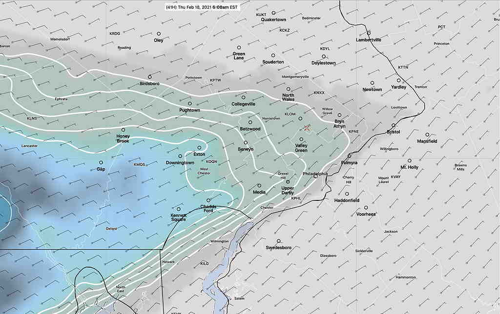
Added Thu 12:32 PM — This update falls into the category of “too much information”  but the latest RAP model shows upper temperatures  (as reflected by the 1000-500 mb “thickness” lines -yellow exceeding “540”) and the 800 mb (6000ft temperatures-orange) have exceeded freezing. 

RAP model critical temperatures and 1000-500 mb “thickness” with MRMS radar at 12 noon . (Click on image for a larger view.)


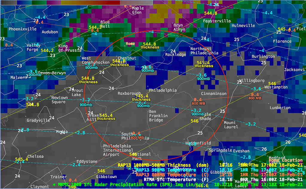
The 800mb (orange lines) is above freezing (0.4ºC) now in Philadelphia and just north.   Superimposed is the radar at 12:17 PM with the heaviest precip moving up towards the northeast.

With the back edge of the heavy precip in sight on radar, that should do it for this storm.


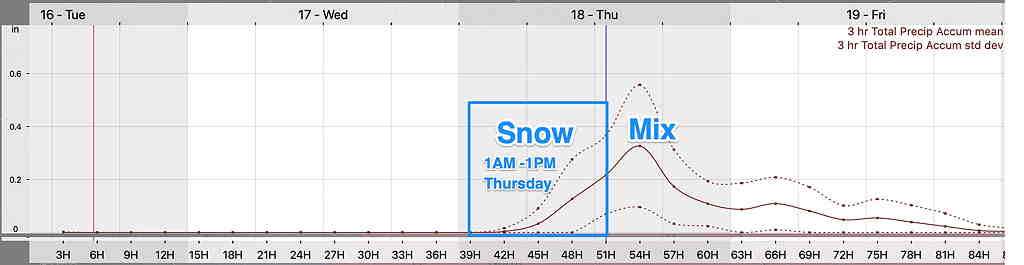
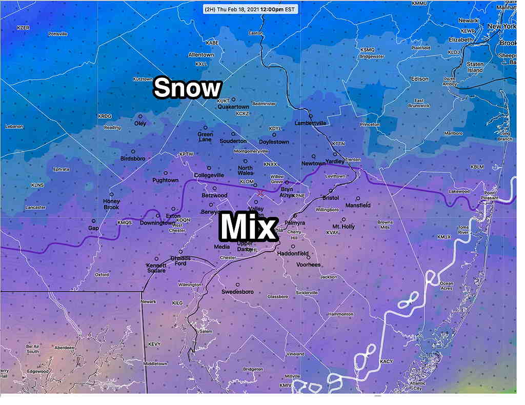
Forecast Updated Thu 11:52 AM — Latest NBM  (National Model Blend) from 10 AM  (it’s run hourly and takes about 1.5 hours to process) shows the transition to a mix occurring right now at noon—

NBM hourly model from 10 AM showing transition occurring now (earlier than RAP and HRRR). Note the position of the 32ºF  wet bulb temperature isotherm (purple line)  which continues to move northward. Wavy white line is 32º surface temperature.  (Click on image for a larger view.)


Forecast Updated Thu 9:03 AM — Latest HRRR expected additional snow forecast for today.  (Whatever you had at 7 AM, add this amount)—

HRRR additional snowfall through 3 PM Thursday (starting at 7 AM) (My neck of the woods has already had at least 2 inches of the ~6 inches forecast going forward as of 9 AM)   (Click on image for a larger view.)
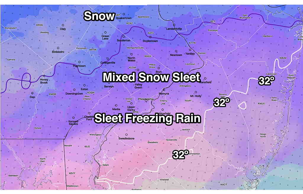
The change to sleet will occur about 2-3 PM according to this morning's NAM model.

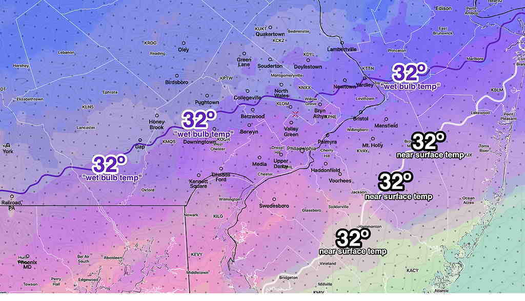
added 9:44 AM— While the NBM model has a precipitation statistics problem, it does have a very useful  average wet bulb temperature parameter which corresponds well to the transition to sleet at 3 PM today—

NBM (12z) “wet bulb temperature” purple line average 610 -40000 meters above ground freezing 32º isotherm at 3 PM. Areas north of the line will be snow, areas south will mix with sleet and rain.  (Click on image for a larger view.)


I wanted to get this update out there.  I didn’t bet on the right horse last night (the NAM).   Last night’s forecast was based mostly on the HRRR which was a middle ground between last night’s NAM and the previous afternoon GFS.   When the evening GFS came out near 11 PM with its low QPF, I kept the HRRR forecast  but suggested near PHL it might be an inch or so less.   I went towards the GFS, not the NAM.  

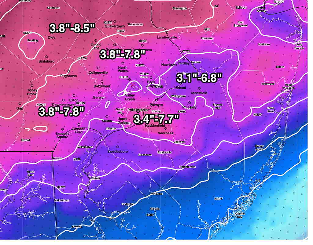
The NAM is run every 6 hours.  The subsequent NAM (06z) was run at 1AM, available about 3 AM.  Here’s the forecast based on that forecast. Maybe I might have used it had I been awake—

NAM (06z) water to snow conversion at 1:12 ratio (Click on image for a larger view.)


 from the earlier Thurs 7:38 AM update…

So, there’s a lot more snow out there than had been predicted.  Last night’s update at 10:55 PM indicated the forecast might be  in trouble when the  GFS water QPF was 0.4” and the NAM was over 1.0”.  

The QPF is looking closer to that predicted by last night’s  NAM and RAP models.  (I had panned the RAP forecast and when the low QPF GFS came out, I had subtracted from the HRRR instead moving towards the NAM.   “Never ignore the NAM”.).

The precipitation has started earlier than most models had predicted.  The cold temperatures has made the snow ratio closer to 1:15  instead of the usual 1:10 or so.  So we have a trifecta of issues: timing, more QPF and a snow ratio that was too low. 

The 4 AM RAP model has snow falling until 4 PM; the changeover to sleet is delayed.  The new RAP, HRRR and NAM will be available soon.    I’m going to go back and look at the 1AM models and see which, if any, got this right.

THURSDAY SNOW FORECAST

Forecast Updated Thu 7:38 AM —  So, there’s a lot more snow out there than had been predicted.  Last night’s update at 10:55 PM indicated the forecast might be  in trouble when the  GFS water QPF was 0.4” and the NAM was over 1.0”.  

The QPF is looking closer to that predicted by last night’s  NAM and RAP models.  (I had panned the RAP forecast and when the low QPF GFS came out, I had subtracted from the HRRR instead moving towards the NAM.   “Never ignore the NAM”.).

The precipitation has started earlier than most models had predicted.  The cold temperatures has made the snow ratio closer to 1:15  instead of the usual 1:10 or so.  So we have a trifecta of issues: timing, more QPF and a snow ratio that was too low. 

The 4 AM RAP model has snow falling until 4 PM; the changeover to sleet is delayed.  The new RAP, HRRR and NAM will be available soon.    I’m going to go back and look at the 1AM models and see which, if any, got this right.


Forecast Updated Wed 10:55 PM —  This is turning into a more uncertain forecast.  The GFS just became available.  Its precipitation axis is similar to the RAP below.  Its  QPF is similar to its runs from earlier today which is half of the latest NAM.  In these situations an average of the NAM and GFS sometimes works.  I’m going to continue with the HRRR forecast below but we may need to subtract an inch or so in the immediate Philadephia area. 


Forecast Updated Wed 10:27 PM — After reviewing additional models (HIRESW, SREF) I think the HRRR below is probably the best snow forecast to hang one’s hat on.  It captures many aspects of the NAM —

HRRR 24 hour snow totals  (Click on image for a larger view.)


Snow starts about 6-7AM and whatever is falling in the afternoon tapers off beginning 3 PM.  Additional light snow/flurries later and in the evening.

All-important is the GFS model. The GFS model becomes available about 10:43 PM.   I’ll update after reviewing it.


Posted earlier Wednesday evening 9:29 PM…

Despite the trend from earlier today for lower snow totals, the latest models have taken a major switch to a colder and snowier forecast.

The axis of heavier precipitation has shifted north and colder temperatures seem to assure that most areas in from around Philadelphia will have a significant snowfall.   The models all seem to have a transition to sleet and freezing rain, but some are having it occur later in the afternoon (3 PM)  instead of the previous 1PM changeover.  QPF values from the NAM model have gone into the 0.75 – 1 inch of water range.

I’ll present the HRRR model graphics, since they capture the change to more snow, similar to the new NAM—

HRRR 24 hour snow totals  (Click on image for a larger view.)


I’m not a big fan of the RAP (RAPid Refresh) but its physics are somewhat aligned with the GFS.     The GFS comes out later tonight. Here’s the RAP model forecast.  I think it’s forecasting too much snow.

RAP (Rapid Refresh Model) snow totals   I think these are too high.  (Click on image for a larger view.)


Here’s the latest Model Blend (NBM 00z) model. I like the NBM.   Yesterday, it was announced that there’s an error with some of its precipitation algorithms that will be corrected next month.   The NBM blends many models.  However, when there is a shift in the forecast, it can lag the trend.  So I’m just presenting its precipitation type forecast.

NBM Precipitation Type expected at 2 PM  Notice the freezing line is fairly far south at 2 PM. (Click on image for a larger view.)


Continued after 9:30 PM as updates above.

THURSDAY’S SNOW UPDATE

Forecast Updated Wed 8:03 PM — This morning's update captured the trend towards lower snow totals.

Tonight's range models will begin to become available over the next hour (NBM, HRRR, SREF, RAP, NAM, NAM-NEST and HIRESW).  

The late afternoon trend continues with the main axis of precipitation falling from Philadelphia and south; these same areas will have the earliest transition to sleet/freezing rain.

This afternoon's Canadian Regional GEM and German ICON model show QPF values of 0.3-0.4 inches water (3-4 inches of snow) prior to the transition to sleet and freezing rain.

I hope to have an update by 9:30 PM.
Forecast Updated Wed 5:10 PM — Quick update. Precipitation values have reduced from yesterday's models.  3-4 inches is the more likely accumulation from the city north.  More details this evening.
Forecast Updated Wed 8:27 AM — The models are still predicting in the general 4-6 inch range of snow accumulation especially north of PHL, followed by sleet and freezing rain.   Some of the models that are run at 1 AM EST in the morning (the 06z Models) are showing a more southern track with less snow.   

Another issue with snow accumulation not to be ignored is the average temperature of the atmosphere up to 18,000 feet (as depicted by a derived parameter called the "1000-500mb thickness" ) is marginally too warm for most snowstorms in our region.   While it will be cold in the lower layers, the setup really supports sleet and freezing rain.    My real day job will take precedence over these forecasts today, but I'll be back this evening for an update.


Forecast Updated Tue 10:24 PM — Tonight's short range models have become available still show a heavy punch of snow in the morning, starting before 7AM Thursday followed by significant sleet and freezing rain. About 5-7 inches of snow before the changeover about 1PM.  Northwest areas of Montco and Bucks may stay all snow with higher accumulations.  

There have been some shifts in the model forecasts. The snow will start a little earlier than previously forecast starting as early 4-6 AM Thursday from southwest to northeast.

NAM-NEST snow accumulation entering at 5-6AM from southwest (Click on image for a larger view.)


The NAM and NAM-NEST are showing a heavier snow accumulation in the morning prior to a change to snow/sleet and eventually sleet.  

The Short Range Ensemble Forecast (SREF), which combines statistical variations of the short range models including the NAM, has quite a spread in the possible snow accumulations and snowfall timing, as depicted in this simple one location meteogram for Blue Bell—

SREF  Blue Bell showing large spread (uncertainty)in possible snow accumulations before a change to sleet The dotted lines are ± 1 sd     (Click on image for a larger view.)


Capturing the spread and uncertainty is the latest Model Blend  (NBM) snowfall totals—

NBM snow total percentiles. ***PLEASE NOTE THAT THE NOAA RELEASED A NOTICE TODAY THAT THEY HAVE FOUND ISSUES IN THE NBM PRECIPITATION STATISTICS. THE PROBLEM TO BE CORRECTED IN MARCH.*** (Click on image for a larger view.)


My preferred model for snowfall/sleet has always been the NAM model or a combined NAM-GFS blend.  Here’s the latest NAM (which tends to run high this much in advance)—

NAM 18z Water to Snow Equivalence conversion 10:1   (Click on image for a larger view.)


The NAM is showing an early burst of heavy snow during the morning.

Additionally, the NAM has an extended period of sleet and freezing rain on top of the snow after 12-1 PM.

This afternoon's GFS model has just become available as I write this.  The possibility of at least a 5-8" generalized snowfall is forecast with the snow -> sleet changeover delayed into the late afternoon.  

As usual, we have uncertainty with a coming snowstorm.  But the trend is for a more significant snow accumulation.    Stay tuned for updates.