WEEKEND WEATHER FORECAST

Sat 09:14 AM Update — This morning’s HRRR continues to show an area of clouds moving in later in the morning today associated with the vorticity

• Some sun early, then considerable cloudiness in the late morning.  Then, a  mix of sun and clouds in the afternoon.
• Some snow flurries possible early evening
• High temperature 32.1º sd 0.9º  (NBM model) Blue Bell.

• Windy, especially mid-day.  Winds 15 mph with higher gusts to 35.\


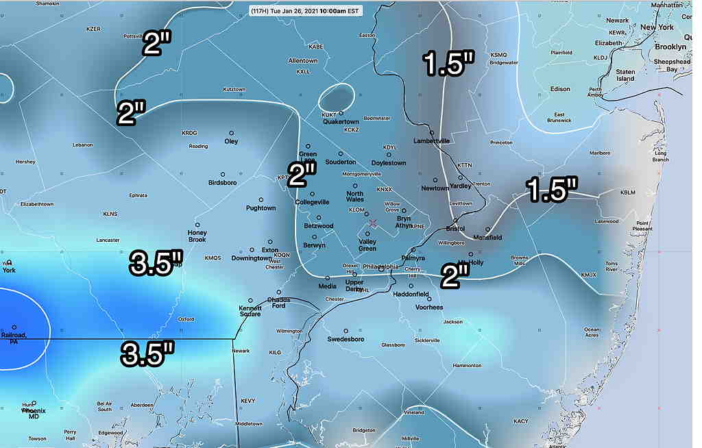
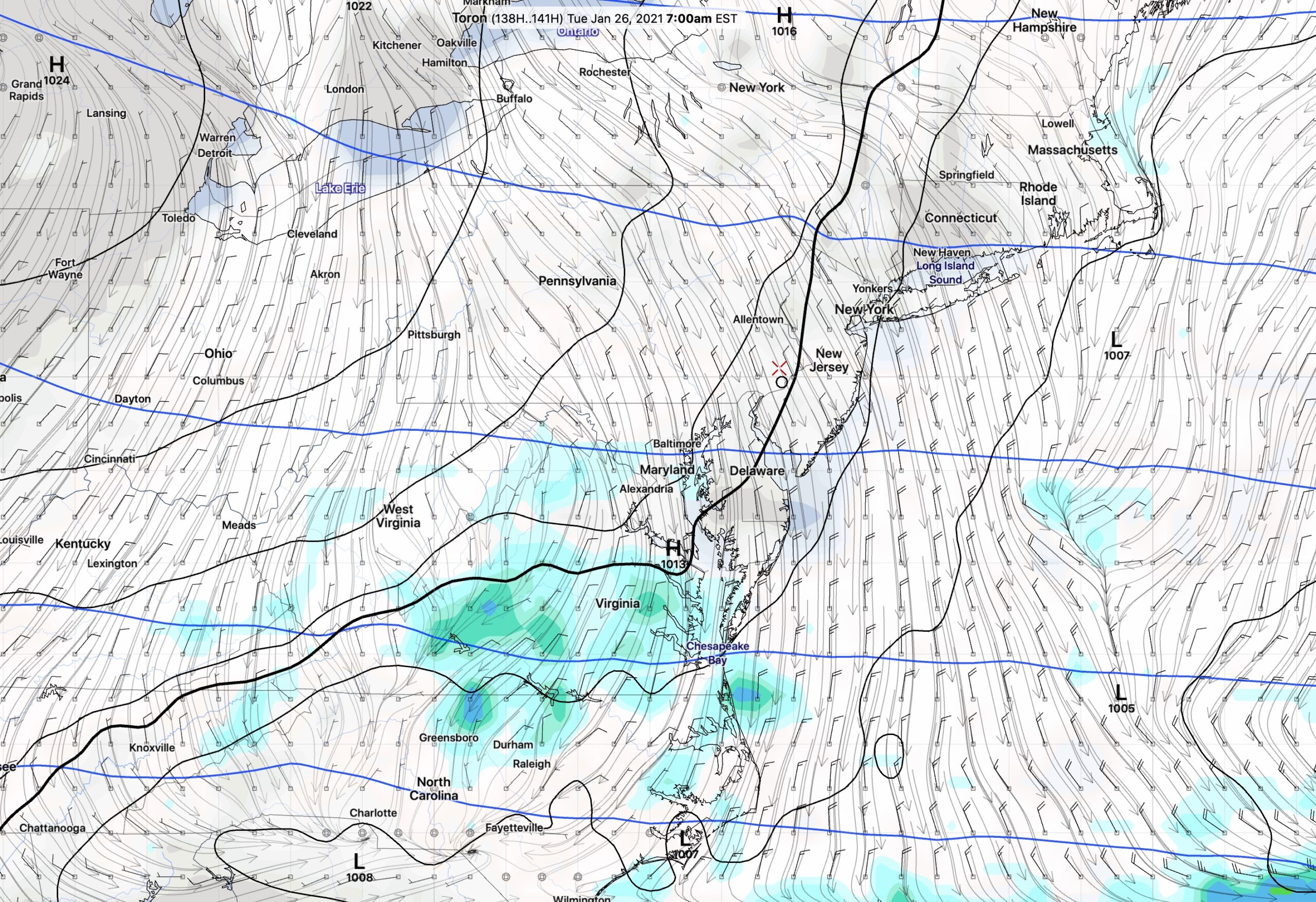
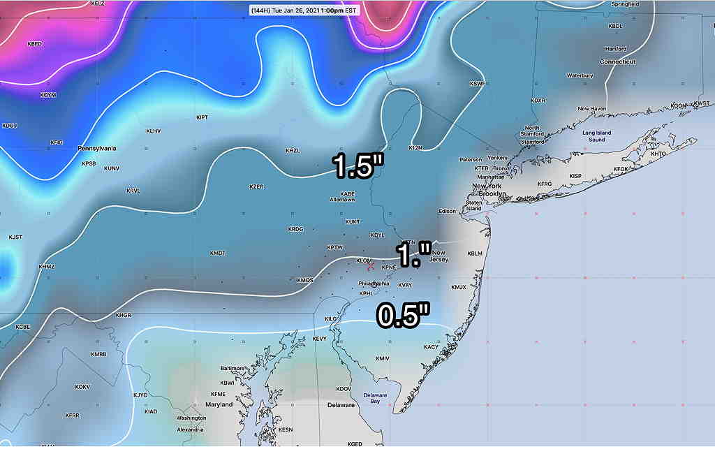
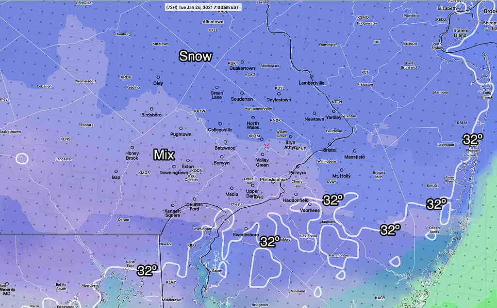
The potential snowfall for Monday night into Tuesday continues to look like a minor event.  The NBM (model blend) picks up the trend with totals of 1-2 inches of snow by 7 AM Tuesday.  (It pretty much ends by 7-9 AM. )  A mix of sleet and freezing rain at some points in the event will limit totals, although there isn’t all that much moisture with this storm to begin with. 

NBM precip categorical type at 7 AM Tuesday. (Not to be confused with actual snow falling at the time- it’s NOT a radar image .)  (Click on image for a larger view.)

Check back for updates later tonight.

From Friday evening…

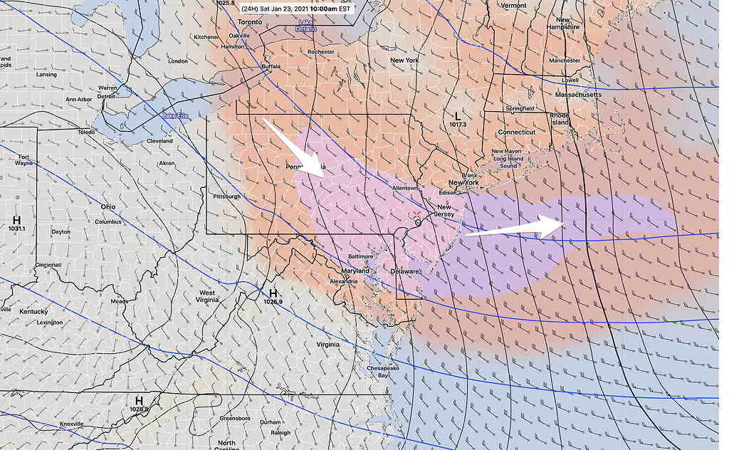
Cold high pressure builds in for Saturday and Sunday.  Ordinarily that means sunny skies, but an area of vorticity,  moisture and cyclonic flow in the upper atmosphere will cause considerable  instability cloudiness during the earlier part of the day Saturday—

SREF model showing area of vorticity (lilac) moving through. (Click on image for a larger view.)

(Note – continuing downtime of the main NOAA weather model distribution server has made some model data unavailable today.)


Saturday —
• Sun early, then considerable cloudiness in the late morning.  A mix of sun and clouds in the afternoon.
• High temperature 31.9º sd 1.1º  (NBM model) Blue Bell.

• Windy, especially mid-day.  Winds 15 mph with higher gusts to 30. 

The upper flow becomes more anti-cyclonic on Sunday.  Fewer clouds, less wind and more sunshine.  Moisture from an approaching storm may allow some high level cloudiness to move in


Sunday —
• Mostly sunny, some high level cloudiness during the late afternoon.
• High temperature 34.6º sd 0.7º  (NBM model) Blue Bell.

• Winds 10 mph gusts to 15

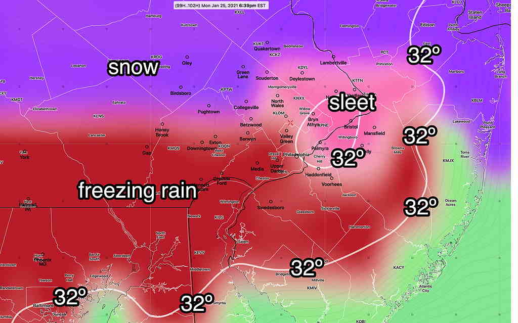
The wintry weather Monday evening into Tuesday looks to be a mixed precipitation event with snow mixing with sleet/freezing rain the back to snow. Final snow totals 1-2 inches by Tuesday morning, but expect changes in this forecast.  Stay tuned.

JUST A SNOW POSSIBILITY

Fri 07:37 AM Update — The next chance of snow for us (Monday evening into Tuesday) is about 96-108 hours in the future, still beyond the range of the short range, higher resolution  models.  (The shorter range, higher resolution models forecast 84-89 hours in advance at best. Many only forecast 48-60 hours in advance.)  

Current operational GFS snow totals by Tuesday afternoon—

GFS snow totals by Tuesday afternoon. (Click on image for a larger view.)

The above GFS snow totals are somewhat similar to the ECMWF (European), Canadian GEM-Gobal and German ICON.  Stay tuned.

Thank you to those of you who took part in my recent user feedback poll.  Here are the final results:
“Users, would you like  to see all  updates posted to Twitter or just the major new posts (as currently done)? “

With it so close, I’m going to stay with only posting major new posts to Twitter,  but with an occasional update also posting. (A slight change to the  current approach I use.)   The updates (such as those on this page) won’t be automatically posted to Twitter.

Thu 08:06 PM Update — Today’s GFS has joined other models (Canadian, European, ICON and GEFS)  in predicting about 1-3 inches of snow here Monday night into Tuesday morning. (Unfortunately, the newer GFS v16 has not been available today due to planned maintenance of NOAA’s servers.)
Current GFS snow totals for Tuesday 10 AM  (Click on image for a larger view.)


A new wrinkle for getting larger snow accumulation is going to be temperatures, which are trending somewhat warmer at certain levels of the atmosphere, especially near Philadelphia.  Many areas will have a sleet/rain mix at times during the event reducing snow totals and making an accurate snow total forecast difficult.   Since the storm is coming during the nighttime hours, a period of sleet or freezing rain is a possibility as temperatures near the ground may drop below freezing—

GFS Precipitation Type (PTYPE) Monday evening (Click on image for a larger view.)

A change back to snow is expected before ending Tuesday morning.

The fine structure of the thermal profile won’t be known until the day before the event.    Stay tuned.


From Wednesday …

Today, several people at work asked me, ‘so where’s the snow?’

The statistical ensemble (GEFS) model continues to forecast a minor snow possibility for the overnight period from Monday into Tuesday morning.  (see yesterday’s post for the precip forecast graphic; it hasn’t changed much with today’s model runs.)

The sort of thing I like to do is compare the soon-to-be-released GFS model version 16 and the current operational GFS model (version 15.2)’

(The GFS 16 is scheduled to become the operational model the first week in February.)

The soon-to-be-released GFS 16 has  significant snowfall for our area, 4-7 inches—

GFS v 16 precip rate forecast for Tuesday 7 AM   (Click on image for a larger view.)


The current operational GFS model has the storm a bust with little development and little snow—

GFS (current operational) forecast Tuesday 7 AM (Click on image for a larger view.)


The current Canadian Global and the European models are closer to the the low end with some snow 1-2 inches.

In the time period in question (~138 hours in the future), the statistical GEFS model is probably the one to consider most—

GEFS snow totals Tuesday morning  (Click on image for a larger view.)


If that’s the case, the soon-to-be-released GFS model v16 has a serious precipitation over-prediction bias. 

The fun of this is to see what happens.   Stay tuned.