[su_note note_color=”#bceaed”]Forecast Review— The HIRESW models did the best with this forecast. The 11 AM -1 PM timeframe was very close. The RAP model picked up the early morning showers. The NAM and NAM NEST over-predicted the second line of showers during the afternoon.[/su_note]
Last night’s early models showed considerable spread with the timing of thunderstorms and showers today. I’ve had more time to look at those models as well as subsequent newer model runs from 2 AM (“06 Z model runs”).
So what’s happening?
The surface front moves through between 11 AM and 1 PM today with showers and thunderstorms as previously forecast. Prior to this time, expect windy and gusty conditions and possibly some scattered showers ahead of the front.
However, at the upper/mid levels of the atmosphere, additional disturbances (areas of “vorticity and vertical motion”) continue to move through in the upper level flow during the afternoon.
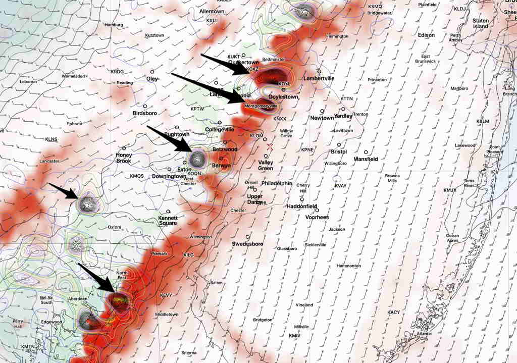
NAM NEST Vertical Velocity 700 mb (10,000 feet) at 3 PM (Black= maxima) (Click on image for a larger view.)
The actual upper air trough moves through slowly with these areas of vorticity triggering showers. Additional scattered showers and thunderstorms are possible during the afternoon until the upper air trough moves through. The NAM NEST shows this activity may be most enhanced at 2-4 PM.
[su_note note_color=”#ffffff”]Updated Wed 10:20 PM — Changes and uncertainty in the latest models. Tonight’s RAP model just available is showing an earlier frontal passage. Showers and thunderstorms move in as early as 7-8AM Thursday.
However tonight’s NAM and NAM NEST show scattered storms late morning and another cluster about 3pm in Philadelphia.
Further Update at 10:30 PM —The HIRESW just available still shows the 11AM -1PM timing.
What looked like a straightforward forecast has become a low confidence forecast with higher than usual uncertainty. [/su_note]
[su_note note_color=”#ffffff”]Updated Wed 05:53 PM — This morning’s models continue with the forecast of thunderstorms moving through Philadelphia around 11AM -1 PM and then slowly moving through NJ during the afternoon.
(Other storms possible much earlier, about 2-4 AM Thursday in far western suburbs.)
Gusty winds Thursday morning and heavy localized rains expected with these storms.
Here’s this mornings HIRESW-ARW2 model showing areas of horizontal moisture convergence (red-yellow) and maximum upward vertical velocity at noontime; the radar image tomorrow will likely show a line of storms at this location and timing.
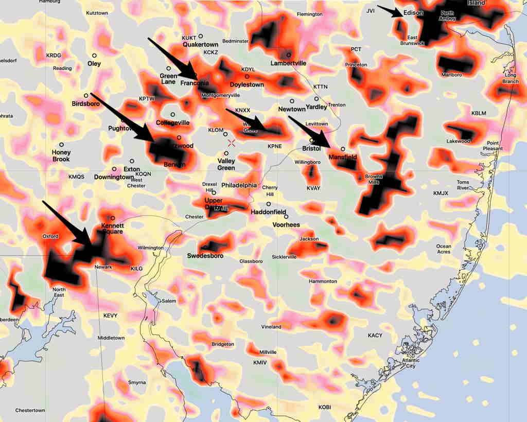
HIRESW ARW2 forecast for noon Thursday showing horizontal moisture convergence (red-yellow). Maximum Upward Vertical Velocity (black arrows pointing to these areas.)
Those areas in NJ may have heavier areas of storms due to more favorable timing for severe weather in the afternoon. [/su_note]
From earlier today..
Following a hot and humid day today (Wednesday) a cold front will approach later in the day. For Wednesday, most models have any thunderstorms remaining in central Pennsylvania and not making it into Philadelphia during the day on Wednesday, although far western suburbs may be touched early this evening.
For Philadelphia, the storms move through in two waves— after midnight and again about noon Thursday.
The models are suggesting that the actual front moves through Philadelphia about 11 AM -1 PM Thursday with showers and thunderstorms at that time—
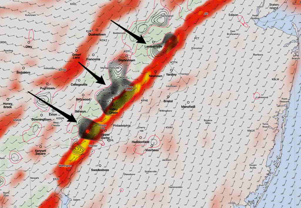
NAM NEST 11 AM Thursday forecast (Red line- likely thunderstorm line position 11 AM with arrows pointing to maximum areas of vertical velocity=strongest storm areas) (Click on image for a larger view.) This is useful, but should not always be taken literally.
However, several models show thunderstorms also breaking out well ahead of the frontal passage, as early as midnight tonight (Wednesday) and about 3 AM ± 2 hours Thursday morning. These overnight storms may be the strongest for the immediate PHL area.
Clearing is expected to occur in Philadelphia after 1-2 PM Thursday, but the line of thunderstorms will take several hours to move through NJ, not reaching the shore until late afternoon or early evening. .