#weather #paweather #wx #pawx #philadelphia #phillywx
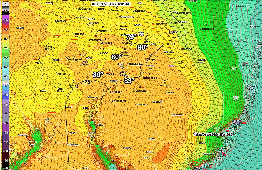
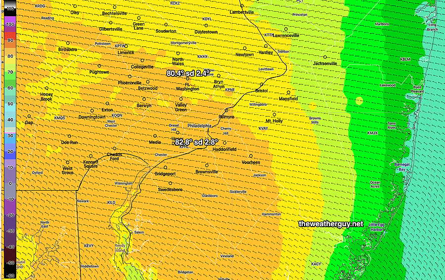
Here’s the RTMA for 3 PM showing the preliminary observed high temperatures for the day—
Friday Forecast Update
Update Fri 04/21 @ 8:22 AM —Large differences remain with the forecast high temperature today. The reason for these forecast temperature differences are slight differences in the origin of the forecast surface wind flow.
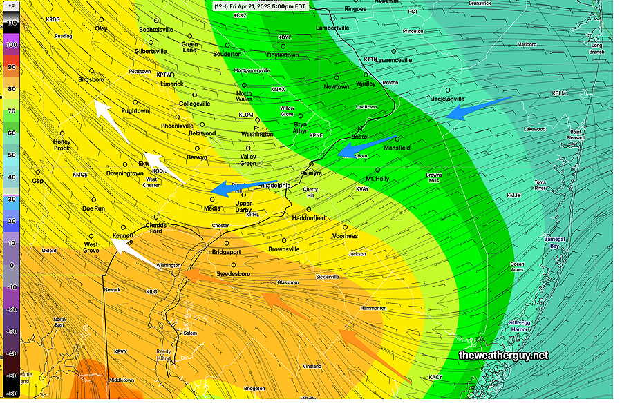
The latest RAP model wind streamlines captures the differences: where the easterly flow originates from the northeast, it will be cooler. Where the easterly flow originates from the southeast, it will be warmer—
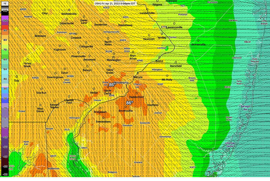
In contrast to the much cooler RAP model forecast, the Canadian high resolution model (HRDPS) forecasts temperature much higher for us today—
The NBM model blend is right in the middle of the two forecasts above—
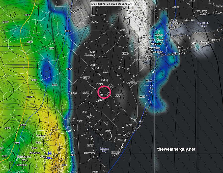
For Saturday, the rain moves in between 5PM and 7 PM. Details in the regular “Weekend Weather Forecast” later tody.
Update Thu 4/20 @ 7:55 PM — Friday is going to be another beautiful day. There has been a reduction in the high temperature forecast for Friday, as expected from last night’s forecasts.
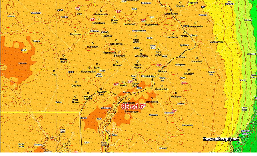
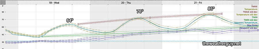
Previous days this week, highs of 85º looked like a certainty for Friday. The latest GFS has reduced its high to about 82º for Friday, while the high resolution mesoscale models (HRRR, NAM-NEST, HREF) have us only in the mid 70s tomorrow.
Not surprisingly, the NBM is forecasting about 80º (with a high standard deviation of about 3.5º). That’s still a high level of uncertainty for next day temperatures. (As usual, my temperatures refer to location Wings Field, Blue Bell, PA.)
Here’s the latest NBM high temps—
As for Saturday, the forecast is for the rain to move in about 6 PM or so.
Huge High Temperature Uncertainty Friday
Update Thu 4/20 8:01 AM — Last night’s models continue with an incredibly large spread in high temperatures for Friday, due to the uncertainty of the easterly wind flow and possibly some low level clouds.
The HRRR and RAP keep us in the low to mid 70s as a high, while the global models (GFS) are in the low to mid 80s! The NBM model captures this — its high temperature standard deviation is almost 6º. That means that of the approximately 40 models that the NBM statistically weights, there’s a range of ± 6º in the forecast highs of 67% of the models. It also means that 33% of the models have even larger differences.
(Typical standard deviation in the NBM high temperature a day in advance is about 1-2º!)
This all boils down to high uncertainty in the forecast high for Friday.
I wouldn’t mind some wonderful 80º temperatures, but I’m leaning towards betting on the lower end of the range right now.
Update Wed 4/19 10:59 PM — Possible big change in the Friday forecast. Tonight’s NAM-NEST shows an easterly wind flow with much cooler temperatures. Just one model, but don’t be surprised if Friday is much cooler than forecast earlier.
Update Wed 04/19 @ 7:53 PM — A strong upper air ridge will be in place over us for the next few days.
For Thursday, we”ll get into the mid to upper 70s and there may be some high thin cirrus cloudiness at times as moisture move up along the upper air ridge.
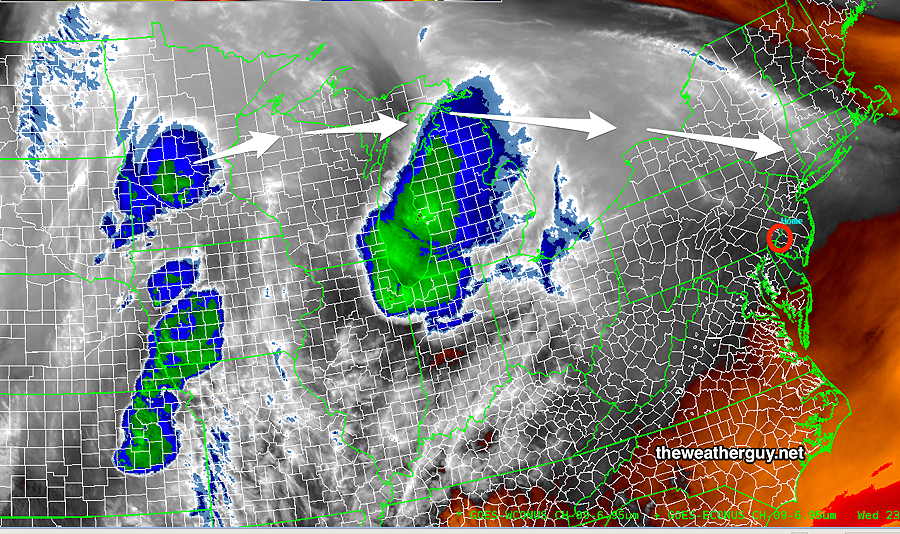
Current Satellite Water Vapor. The arrows show the path of the disturbances moving far north of us on Thursday—
Temperatures will continue to warm and Friday will be very warm for April.
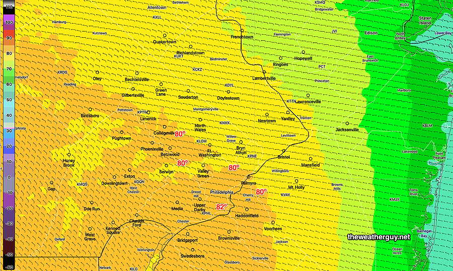
Friday’s forecast high temperatures—
The forecast for the weekend is clarifying. A strong cold front moves through Saturday night with some possibly moderate to heavy rain. It looks like the precipitation moves in about 4-7PM.
It should clear out for Sunday with much cooler weather.
Wednesday thru Friday
Update Tue 04/18 @ 5:35 PM — We had less cloudiness and higher temperatures Tuesday than forecast yesterday. I might add less wind as well. The clouds were mostly north of Quakertown
Wednesday through Friday looks good with warming temperatures. A few upper air disturbances on Thursday may bring a mix of clouds and sun. Friday looks even nicer and much warmer.
Temperatures will become summer-like again by Friday!
The forecast for the weekend is in flux. The ECMWF has the cold front with shower/storms late Saturday. The GFS is slower and has the showers/storms into Sunday.
Tuesday Forecast Update
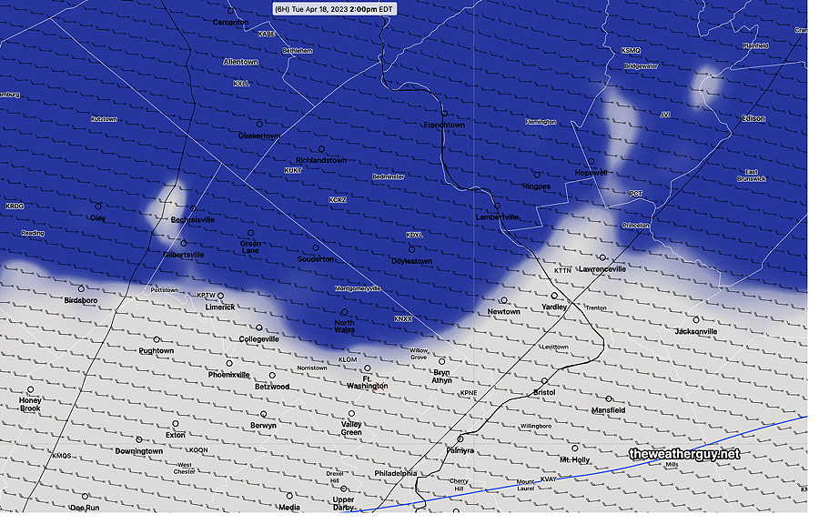
Update Tue 04/18 @ 12:01 PM — This morning’s models have backed off on the clouds for today with the exception of areas north of the city.
Update Mon 04/17 @ 6:10 PM — The secondary cold front moved through late this afternoon with just some clouds. Colder air is moving in and will be with us through part of Wednesday.
Tuesday will be relatively chilly compared to recent days. Highs will be in the mid 50s. It will be windy and there will be a fair amount of instability cloudiness developing late morning through much of the afternoon, especially in areas from the city northward.
More sun on Wednesday, still windy. Temperatures will return to the 70s on Thursday. Friday looks good.
Weekend Early Outlook- part of the weekend (likely Sunday) looks to be quite interesting as heavy rain and thunderstorms as surface low pressure develops along a strong cold front.
Previously Posted Sun 8:53 PM —
A cold front moves through Sunday night about 1 AM with light scattered showers. No severe weather. Cooler air filters in on Monday,
Clouds linger Monday morning, then sunshine from about 10 to 3 PM.
Additional cloudiness with a secondary cold front late afternoon. Colder air for Monday night and Tuesday and quite windy. Very windy Wednesday. (Average seasonal high is about 65º-66º)
Moderating temperatures by Thursday.
(Next weekend looks a bit wet.)
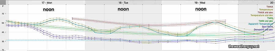
Here’s the latest NBM temperature meteogram for Blue Bell, PA for Monday through Wednesday—