Update Sun 04/30 @ 4:24 PM — Areas of very heavy rain continue, especially in New Jersey, where large areas have received close to 5″ of rain since Friday. An additional inch or more is possible!
The latest HRRR shows some heavy downpours with thunderstorms possible between 8 PM and midnight ahead of a cold front passage.
The actual cold front will move through between 10 PM and midnight and periods of heavy rain will continue through the frontal passage.
Wind gusts may exceed 55 mph in some areas around midnight as a pressure gradient develops with the departing low pressure system.
Update Sun 04/30 @ 9:52 AM — The rain has moved in as expected and periods of rain, heavy at times, will fall throughout the day and evening hours. Total accumulations for the day will be in the 0.9″ to 1.5″ range with some locally higher amounts.
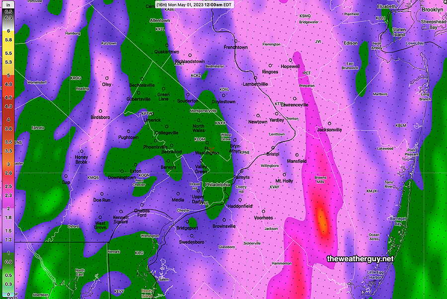
Each model has a somewhat different axis location for the heavy rain but the HRRR, which did best Friday night, now has a somewhat different heavy rain axis than it had last night—
Latest 12z HRRR total rain accumulation by midnight (Click on image for a larger view.)
A strong cold front will move through about 10 PM to midnight tonight. The HRRR and especially the RAP model are showing some low CAPE values (300 J/Kg).
Moderately high shear values (30 1/s) with that CAPE suggests the possibility of thunderstorm formation between 6 PM and 10 PM ahead of the front. Strong wind gusts of near 40 mph are possible. No tornadoes expected and it’s currently a low severity risk.
Forecast Update and the Broad Street Run
Update Sat 04/29 @ 10:25 PM — A quick update. The precipitation forecast from this afternoon remains intact. It showed fairly heavy rain through 2 PM.
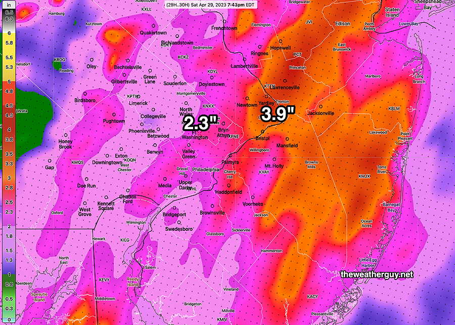
The latest models tonight show heavier rain and possibly stormier weather during the afternoon and early evening hours on Sunday. As a cold front approaches Sunday evening, some thunderstorms can’t be ruled out.
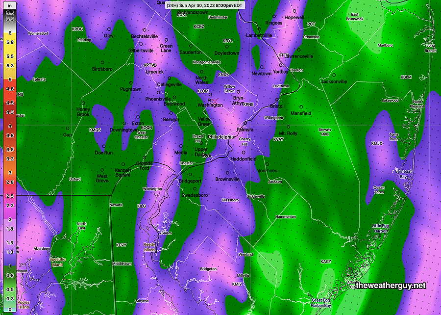
Here’s the updated HRRR rain totals forecast through 8 PM Sunday evening—
Tonight’s 00z HRRR rain totals forecast through 8 PM Sunday. Many areas will see 1 to as much 1.5″ additional rain. (Click on image for a larger view.)
Update Sat 04/29 @ 4:51 PM — Looking back to yesterday’s model forecasts, yesterday’s 18z HRRR model was most accurate with its precipitation amounts and the axis of heavy rain in NJ.
Today’s 18z HRRR is now available and here’s its forecast amounts for the period now through 2 PM Sunday with special emphasis on the Broad Street Run location—
Today’s 18z HRRR model forecast total rainfall for Sunday at 2 PM. (Click on image for a larger view.)
Update Sat 04/29 @ 10:12 AM — The rain has tapered off a few hours earlier than forecast, but light drizzle remains. The latest 12z NBM still shows light drizzle through much of Saturday afternoon. The latest 12z RAP and HRRR also show a few very widelyscattered showers into the evening.
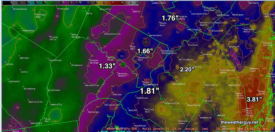
The rain totals from yesterday’s NAM-NEST weren’t all that far off, but as is often the case, the exact location of the heavy rain axis was different than forecast, in this case further east. Here’s the MRMS based rain totals so far—
MRMS-based 24 hour estimated rain totals through 8 AM Saturday. (Click on image for a larger view.)
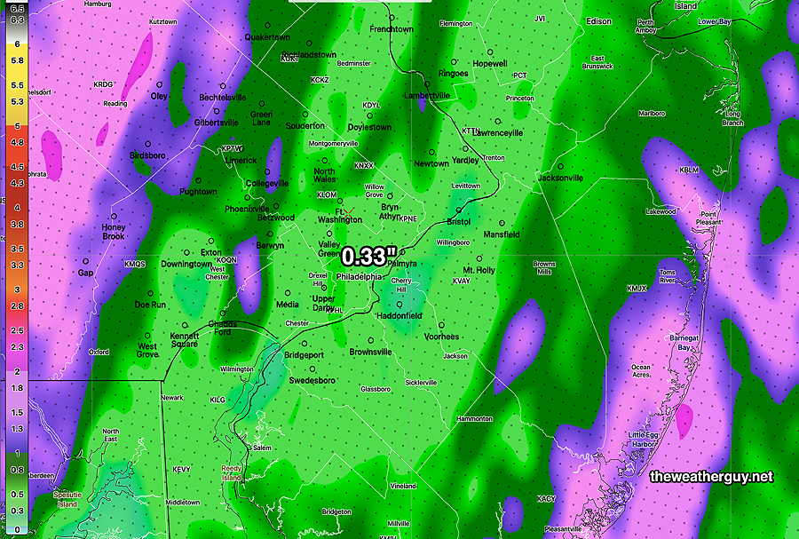
As for Sunday and the Broad Street Run, the current updated forecast is for the rain to move back in about 8-9 AM. Light and scattered at first, then moderate to heavy rain through much of the daytime. Another 0.30″ to 1.5″ expected.
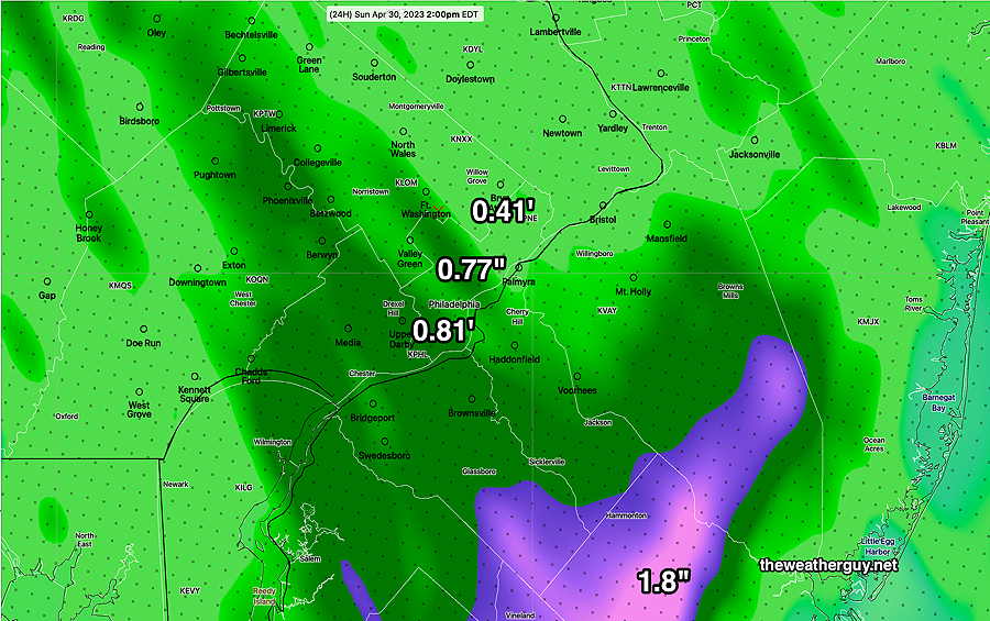
If any consolation for the runners. the latest 12z HRRR shows only 0.33 inches of rain for Broad Street during the day, with the heaviest rain falling to the west and east—
Today’s12z HRRR accumulated rain forecast for Sunday. (Click on image for a larger view.)
As we saw today, the models aren’t always that good with forecasting the placement of the heaviest rain axis, so don’t hold me to that ‘lighter” 0.33 inches along Broad Street.
Update Fri 4/28 9:53 PM — It looks like the steady rain ends around noon on Saturday. Very widely scattered showers follow through the evening.
Previously Posted Fri 5:19 PM —
As outlined in several posts this past week, a blocked weather pattern will keep the major determinants of our weather relatively unchanged from today, Friday, through possibly next Thursday!
Blocked patterns are somewhat common in springtime and for this pattern, our area falls on the chilly and wet side of things —
12z ICON model jet stream wind forecast for Sunday. An Omega ( Ω ) block is shown with the white wind flow arrows. The upper air low (L) approaching the Great Lakes will close off and be relatively stationary for almost 5-7 days giving us periods of cool wet weather.
Rainfall from Friday afternoon through Saturday afternoon will total 2-3.9 inches of rain according to the latest NAM-NEST—
Today’s 18z NAM-NEST total rainfall through Saturday evening. Additional rain on Sunday! (Click on image for a larger view.)
It should be noted that the NBM has much lower precip totals for Saturday, on the order of only 1.5″. The NBM shows about 3″ total for the weekend.
I should also note while the models have been consistent with this weekend’s rainy forecast, these type of weather scenarios driven by upper air low pressure systems often change dramatically in the short-range. Already, the rainfall for the first half of the weekend is forecast to be more substantial than the rainfall predicted for Sunday, a significant change. Stay tuned.
Saturday
Cloudy with continued rain. Rain may taper off far south and west of the city late afternoon, but continued spotty rain/showers are forecast for much of Saturday afternoon from the city, north and west. Windy and gusty.
High temperature 56.5º sd 2.5º ( NBM model location Blue Bell, PA)
Previously Posted Fri 5:19 PM —
Sunday
Spotty rain develops during the morning and becomes heavy during the mid afternoon. An additional 1.25 inches of rain possible. Milder. Windy and gusty.
High temperature 63.8.º sd 1.5º ( NBM model location Blue Bell, PA)
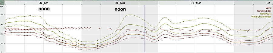
Winds
NBM forecast winds and wind gusts (with standard deviation) for location Blue Bell, PA Wings Field.