Overview: A semi- tropical type storm in the Atlantic brought an easterly damp flow to us on Friday. That low pressure system will depart Friday night.
High pressure will build in with a southwesterly flow that will bring warm temps on Saturday, but a weak front will move through during the afternoon.
GFS 5 PM upper air wind/contours and areas of mid levelvorticity (1) (concentric circles) with weak front move through on Saturday, setting off isolated light showers mostly west of the city. Most areas dry. (Click on image for a larger view.)
Saturday
Mostly sunny, occasional brief periods of low clouds both in the morning and afternoon. A slight chance of isolated showers, especially north and west of Philadelphia in the mid to late afternoon. Most areas dry. Warm and somewhat humid. High temp 84.2º ± 1.3º NBM model, Blue Bell.
Sunday
Sunny and and pleasant. Much less humid. High temp 80.5º ± 1.8º NBM model, Blue Bell.
The Week Ahead
Autumn arrives next week. Close to schedule, in the Wednesday to Thursday time frame, will be the arrival of a strong cold front. Some interesting weather possible with this front.
In the same time frame, the ICON model, for several model runs, has been forecasting a coastal tropical-type low pressure system moving up the coast with a sharp dip in the jet-stream. The Canadian Global GEM and to some extent, the GEFS, show a somewhat similar development, but they differ considerably in the extent of development and sharpness of the developing jet trough.
Interestingly, a derived parameter called the 1000-500 mb thickness line (specifically, the 540 dm line) (the winter-time rough determination of the rain-snow line) makes its first appearance in several months on our weather maps next week.
ICON model forecast for 8 AM Wednesday. Red line is the “1000-500mb : 540 Thickness line” (Click on image for a larger view.)
Update Wed 7:15 PM— No change; heavy activity remains far northwest areas. GFS continues with some showers around Philadelphia around 8-9 PM, while most of the high resolution models don’t have any showers until after midnight and whatever makes it here won’t be too significant.
Thursday is looking more tranquil than previously thought.
Updated Wed 1:30 PM — This morning’s models are in two camps: the high resolution models have the main thunderstorm and rain activity remaining to our far north and west this evening with some rain moving in around midnight and afterwards.
In the other camp is the GFS (and Canadian GEM) models which also keep the main area of thunderstorms to our north and west, but have some scattered rain and thunderstorm activity breaking out about 7-9 PM in the immediate Philadelphia area. In the past several months, the GFS timing and placement of showers/thunderstorms has been better than the high resolution models, so I’m going to lean towards its forecast.
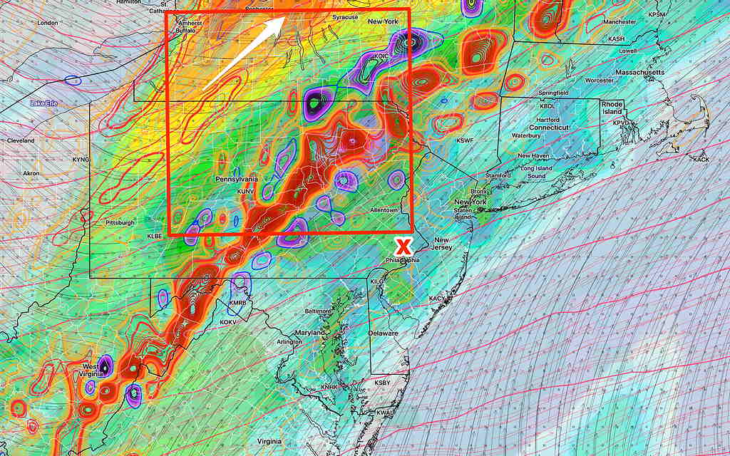
Updated Wed 8:40AM— see graphic caption
Most of the energy (vorticity – colored concentric contours) remains in what’s called the “right entrance region of the jet streak” (red box). This region stays far northwest of the city (Lehigh Valley) for tonight as the jet streak (white arrow) exits far northwest. Some rain and showers move in about 11 PM or so tonight, but the heaviest rain and thunderstorms stay far northwest tonight. A different setup for Thursday…stay tuned. (Click on image for a larger view.)
Updated Tue @ 8:44 PM — It looks like the tropical systems (2) (3) will stay to our south and east. A cold front sags into our area late Wednesday evening into pre-dawn Thursday but will stall.
It currently seems as though most of the thunderstorm activity with the front will weaken by it time it gets to Philadelphia Wednesday night with just some residual rain/showers.
With the front stalled near us, showers and thunderstorms are possible Thursday and Friday. Some moisture from the Atlantic tropical system may affect us Friday.
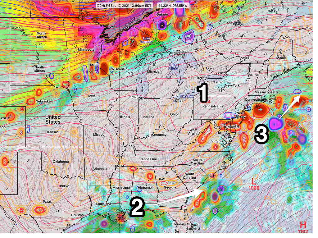
Weekend looks good after a cloudy start as high pressure (1) builds in.
GFS 18z upper air forecast for Friday at noon. Upper air winds and contours and areas of vorticity. (Round concentric contours are areas of vorticity.) Tropical system (3) passes east of us. Remnants of Nicholas (2) remain to our south, but some moisture will be brought northward. High pressure (1) will build in for the weekend. (Click on image for a larger view.)
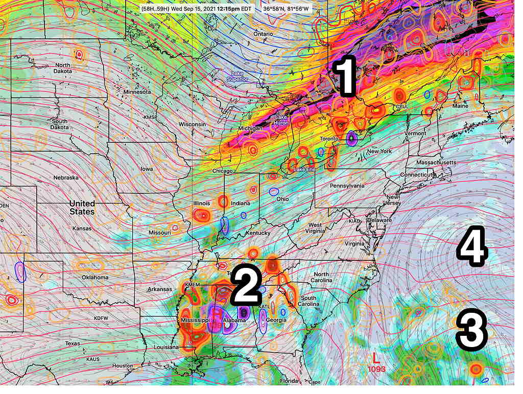
Original post from Monday— High pressure (4) off the Atlantic coast will bring a southwesterly flow of very warm and humid air to the Philadelphia area this week. A somewhat stationary cold front (1) will remain to our north but may slowly sink south towards Thursday—
GFS 06z forecast Wednesday noon. (Upper air contours, near surface winds. Round contours are areas of vorticity.) (Click on image for a larger view.)
There’s considerable uncertainty in the forecast for later in the week. The models are inconsistently handling two tropical-like disturbances (Remnants of Tropical Storm Nicholas-2) and a second tropical type disturbance near the Bahamas (3).
Even without the tropical disturbances, it’s unclear how much cloudiness and instability will develop in our area with the unseasonable heat and humidity.
While the forecasts on the TV/radio suggest just warm/hot and humid days, I suspect there might be considerable cloudiness at times with scattered showers/thunderstorms as the week goes on. To be watched is tropical disturbance #3 which may trend closer to the NJ coast than currently forecast.