I took a quick look at the thermal profiles from this morning’s model run… A bit warm in the atmosphere around daybreak, (rain mixes in) before the storm begins to deepen. This will reduce accumulations in Philadelphia area by several inches. 8 inches looking like a good guess, still the higher amounts, 12+ north and west of the city.
We’ll need to wait until this evening for the real final totals- about 9:45 PM
At work…not much time, but a quick update for the snowstorm in Philly tomorrow. The latest NAM has become available. QPF values, somewhat less, still more than 1.09 inches water in PHL. Band of heavier snow north and west from Valley Forge and Northern Montgomery county and north.
Temperatures at critical levels may allow some mixed precip in PHL during the morning, but a changeover back to all snow in the afternoon. Timing still on track as earlier posts have mentioned. Still going with 12 inches in PHL, less along the adjacent counties SE of PHL, 18 + in western and northern suburbs. (As was the case with the last storm, this is accumulation POTENTIAL. March snowstorms have their own thermal issues from solar insolation effects, reducing totals.)
A busy day at work for me….won’t have time for elaborate posts or evalution of other models until this evening. The all important data becomes available about 9:15 PM and the 3D temperature profiles about 9:45 PM.
Here’s the latest on the snowstorm expected Wednesday. Tonight’s NAM data along with this afternoon’s model runs show high continuity suggesting that this is likely to be a high confidence forecast.
Latest NAM has a QPF of 1.34 inches water for PHL, higher amounts north and west of Philadelphia. (Expect those numbers to change with each model run. It’s the nature of weather prediction.)
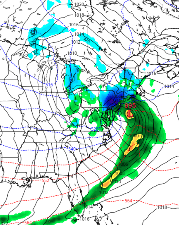
NAM Forecast Wednesday 1pm. A little less intense than this afternoon’s NAM
Still a significant snowstorm, with snow totals 12-18 inches as a current best guess.
Snow starts as a wet mix between 7-10 pm Tuesday night but changes to snow overnight. Snow falls moderate to heavy after daybreak Wednesday , tapering off about 6pm.
I’ll try to update tomorrow morning about 9:15 am.
[su_note note_color=”#ebf2d9″]Tonight’s GFS has an almost identical QPF of 1.33 inches water. GFS has heavier snow earlier on Wednesday [/su_note]