The latest NAM data has become available. Following a rainy night tonight, storm intensification as previously predicted occurs as a secondary low pressure system winds up south of Long Island and moves southeastward.
Temperatures at critical levels of the atmosphere will become cold enough for snow as early as 7-10 AM, so the rain will transition to wet snow at that time. QPF values as high as 0.70 inches water would ordinarily result in 7+ inches of snow, but for all the reasons enumerated in previous posts, total accumulations will be much less and difficult to estimate. Preferential grassy surface accumulations will still hold, with even less on paved and asphalt surfaces. Best guess is still 2-4 inches on grassy surfaces.
Strong winds develop during the afternoon on Friday, with highest winds during the afternoon. The HRRR model has predicted wind gusts to be as high as 60mph!
This afternoon’s model runs have become available and precipitation amounts have returned to values seen last night- QPF values for the storm range from from over 1.25 inches water in PHL to over 2-3 inches water in from Montgomery county and northward.
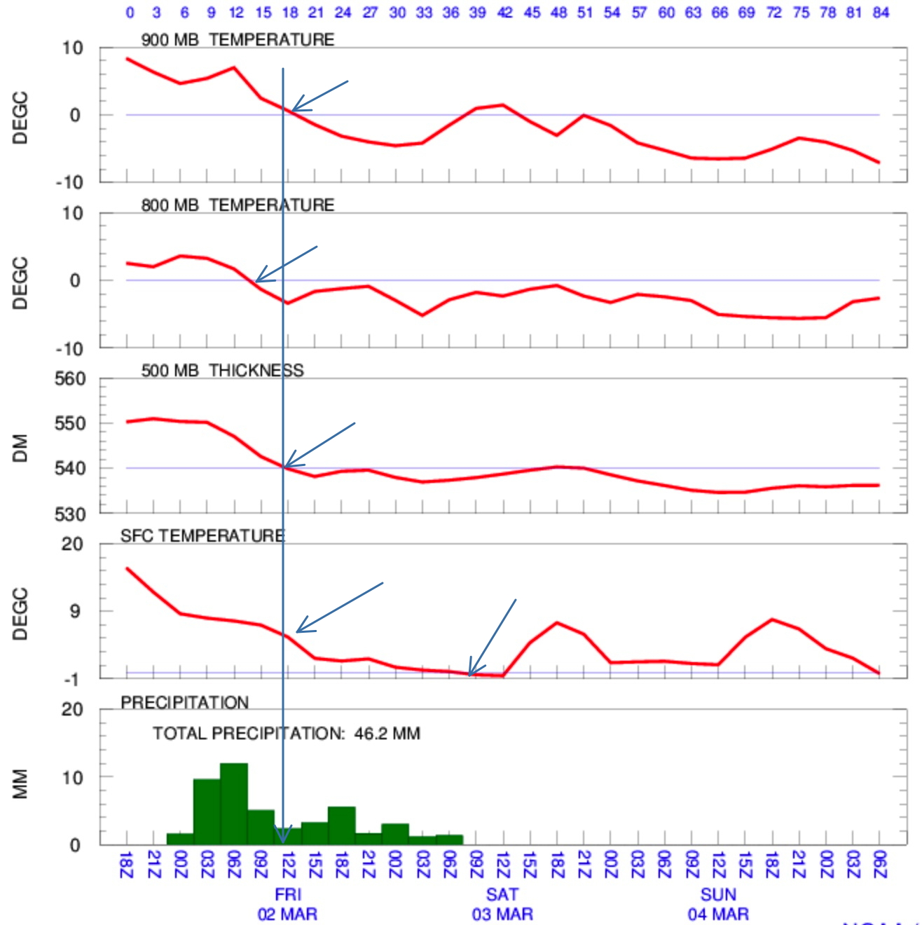
The concerns with this storm is the changeover to snow. Based on the models (see meteogram below), temperatures at critical levels of the atmosphere drop below freezing about 7-10 AM, allowing precipitation to fall as snow. BUT air temperatures and ground temperatures will remain at or above freezing.
NAM meteogram from Thurs afternoon.
There’s little doubt that a changeover to snow will occur in PHL and areas north and west. What is almost impossible to predict is snowfall accumulation, since the following factors are in play–
The snow is falling in March, during the daytime hours. Solar insolation through clouds tends to melt snow on asphalt roadways.
Ground temperatures have been warm for days.
While temperatures aloft will support snow, air temperatures at the surface are not predicted to fall below freezing until evening.
If this were a storm during the first week in January with cold temperatures for days, this would be 7+ inch snowfall. BUT tomorrow’s storm has too many competing factors. So anyone making a guess for accumulations in the immediate PHL area is doing just that- making a best guess.
My best guess is 2-4 inches on mostly grassy surfaces and cars is likely, especially if snowfall rates are high. But expect roadways to be mostly wet and slushy, not icy.
It will look quite stormy from your window, especially since winds are expected to be gusty and high.
This is an unusual storm with an unusual track- the storm is blocked and expected to move south and eastward. Much of snow potential is based on wrap-around flow from the low; the models are notoriously poor at accurately predicting wrap- around precipitation.
Either way, it will melt away with any sun on Saturday!
I’ll update about 9:45 or so this evening with the next NAM run.
This morning’s models continue to change regarding placement of maximum precipitation bands, with the general trend for lower amounts of wrap around snow Friday afternoon in Philadelphia. Most of the action will be north of our area. I expect things to continue to change. Stay tuned to tonight’s forecast, about 9:30 pm