
A quick update. Tonight’s NAM has the Wednesday storm stalling and moving away from us again! So another brush by the fringe of the storm. Enough for me to find another hobby!
Daily Archives: Sunday, March 18, 2018 11:03 pm
WOW- YET ANOTHER CHANGE IN THE FORECAST!
This potential storm for Philadelphia for Tuesday through Wednesday evening has been on the metaphorical radar for almost a week. The binary nature of the storm and the inherent complexity in modeling such a complex system has pushed the models beyond their limits.
I’ve been ending each of my posts with “expect changes”. I’ve been doing this for a reason–
There has been tremendous variations in the deterministic model forecast over the past few days. The main system was expected on Tuesday, then this system was expected to be suppressed to our south and the Wednesday system further suppressed eastward.
The statistical (Ensemble-based ) models have maintained a strong signal of a storm from Tuesday through Wednesday and have never stopped showing this.
This afternoon’s NAM model has just becoming available. It shows the Tuesday storm to be relatively minimal, but energy and intensification and phasing of the jet streams now occurs with the second storm on Wednesday. This second system appears to intensify and hug the coastline!
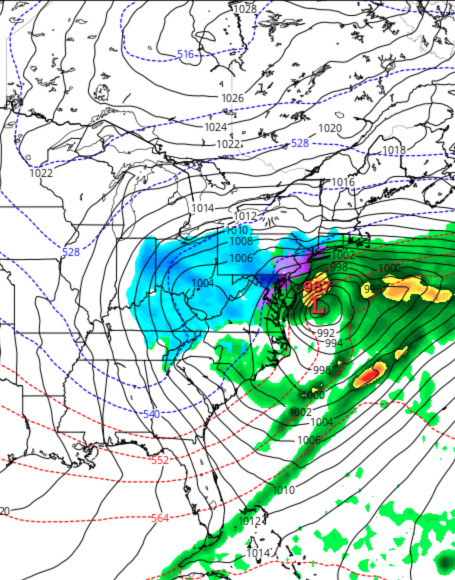
So we’re not out of the woods yet! Indeed, if the NAM is correct, we’ll have a major nor’easter for Wednesday. Due to Daylight Saving Time, the major models will become available very late.
I’ll be traveling this entire week so updates will not be anywhere as frequent as in past storms! (I must confess, this past Friday, I moved my airline reservations to Monday instead of Wednesday to avoid weather-related travel problems. This morning, I thought I had made a mistake; but maybe not! )
YET ANOTHER MODEL CHANGE!
Last night’s models continue to change with the forecast for the two storms that’s been forecast for Tuesday through Wednesday evening.
Many deterministic models (NAM, NAVGEM (Navy) and to some extent the ECMWF (European) now suppress the storms to our south, even on Tuesday! Only the GFS and Canadian models have a precipitation shield that extends into the Philadelphia area as the storm moves to our south. This would mean less QPF, although it may mean colder temperatures, flipping things to more snow rather than rain. (We’re still looking at small amounts, falling in March during the daytime->little accumulations.)
On the other hand, the statistical versions of the models (the ensembles), consistently show some signal for mixed precip in Philadelphia for both Tuesday and Wednesday.
The Wednesday storm also seems to be suppressed to our south and east, with most, but not all models.
So right now, it’s looking like the brunt of both storms will miss us, with the Tuesday storm northern fringe just affecting us and the Wednesday western fringe either just affecting us or missing us.
Expect other changes!
[su_note note_color=”#ebf2d9″]Sunday Noon Update: This morning’s NAM and GFS continue with the trend to suppress the two storms’ precipitation to our south and east both Tuesday and Wednesday. It appears that mostly Delaware and Maryland will be affected, with only fringe effects into southern counties of SE Pennsylanvia. Philadelphia and areas north will be minimally affected, as it appears now. [/su_note]