#weather #paweather #wx #pawx #philadelphia #phillywx
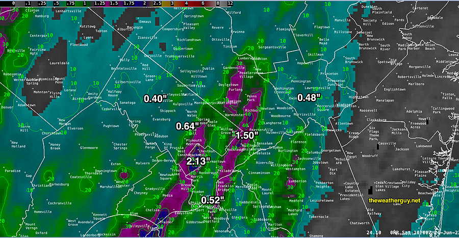
Rainfall Totals
Update Sat 06/24 @ 8:15 AM —
Rain Update
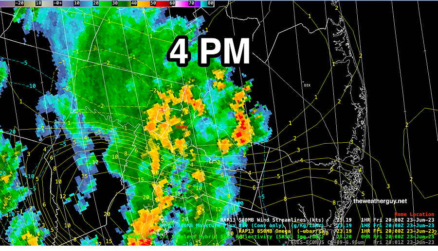
Update Fri 06/23 @ 4:29 PM — Many of us are finally seeing some moderate to heavy rain that’s been over-promised over the past few days.
At 1:30 PM, things were beginning to develop well to our south—
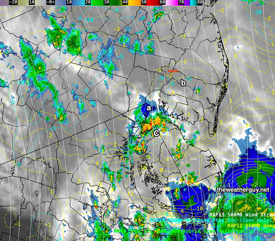
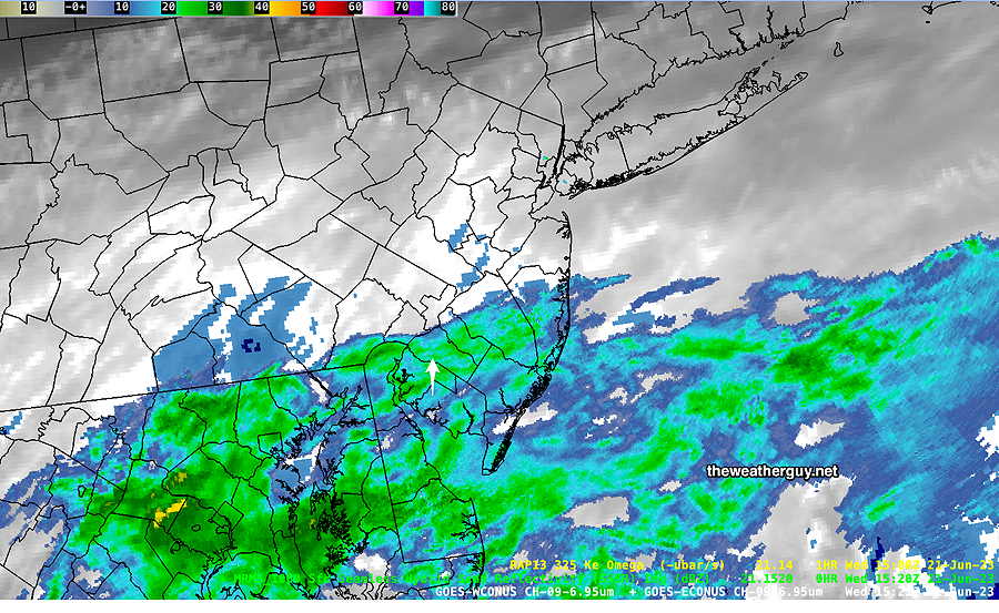
At 4 PM—
I always like to go back and look at this morning’s models to see if any of them got this forecast right. It looks like the HRESW models along with the HREF ensemble did pretty good with this forecast. Unfortunately, one never knows which model group, if any, are going to be forecasting anything close to reality.
Do you want to try your hand at predicting thunderstorms?
An excellent site for just about anything you might need (with the exception of downloading your own data and doing the computations) is the SPC Hourly Mesoscale Analysis page. Take a look.
Show More
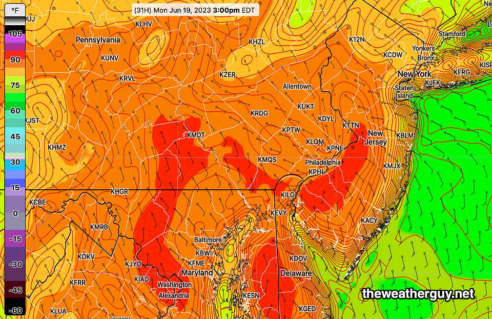
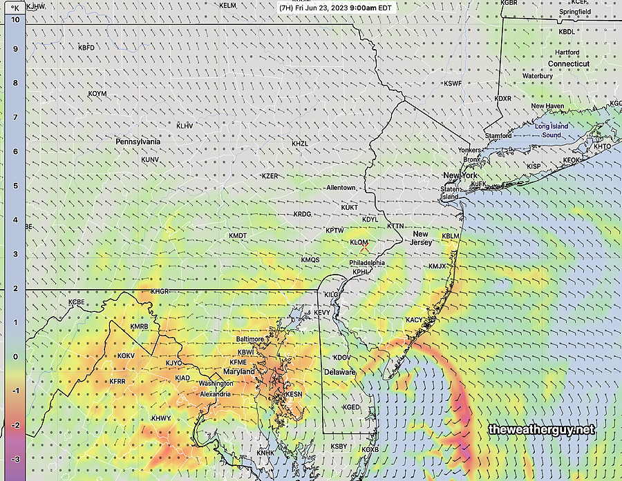
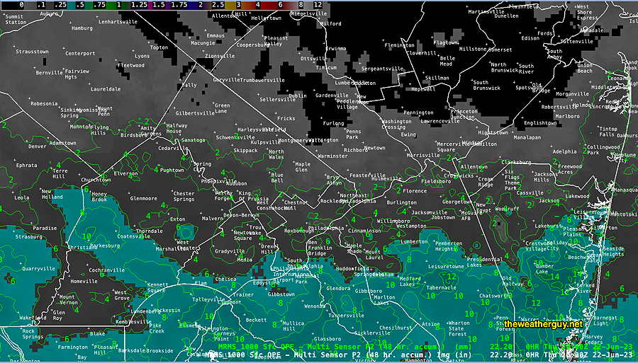
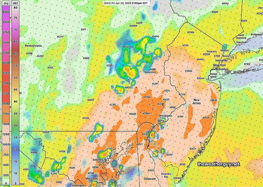
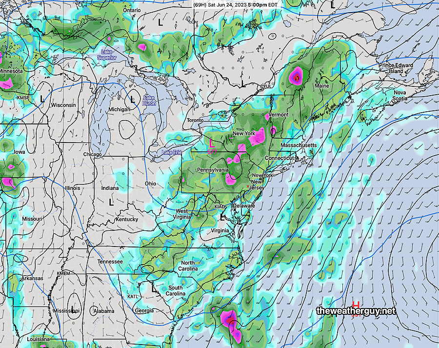
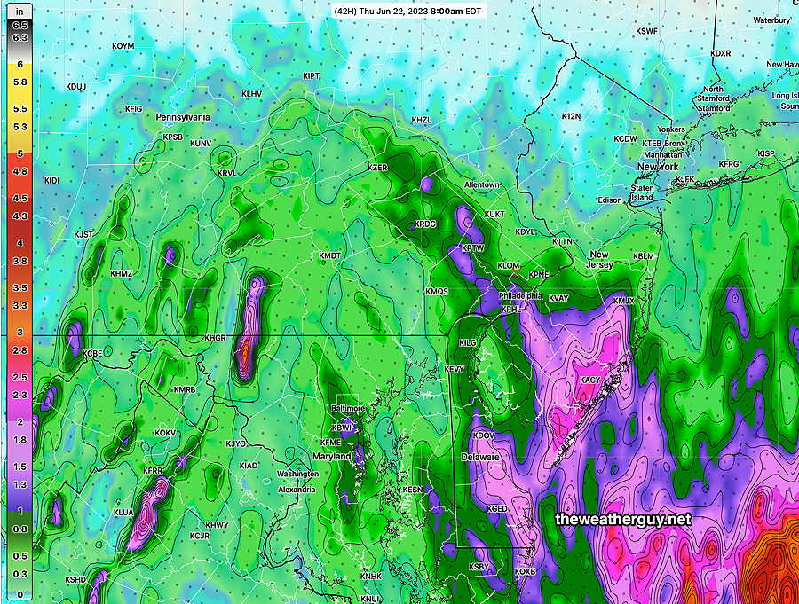
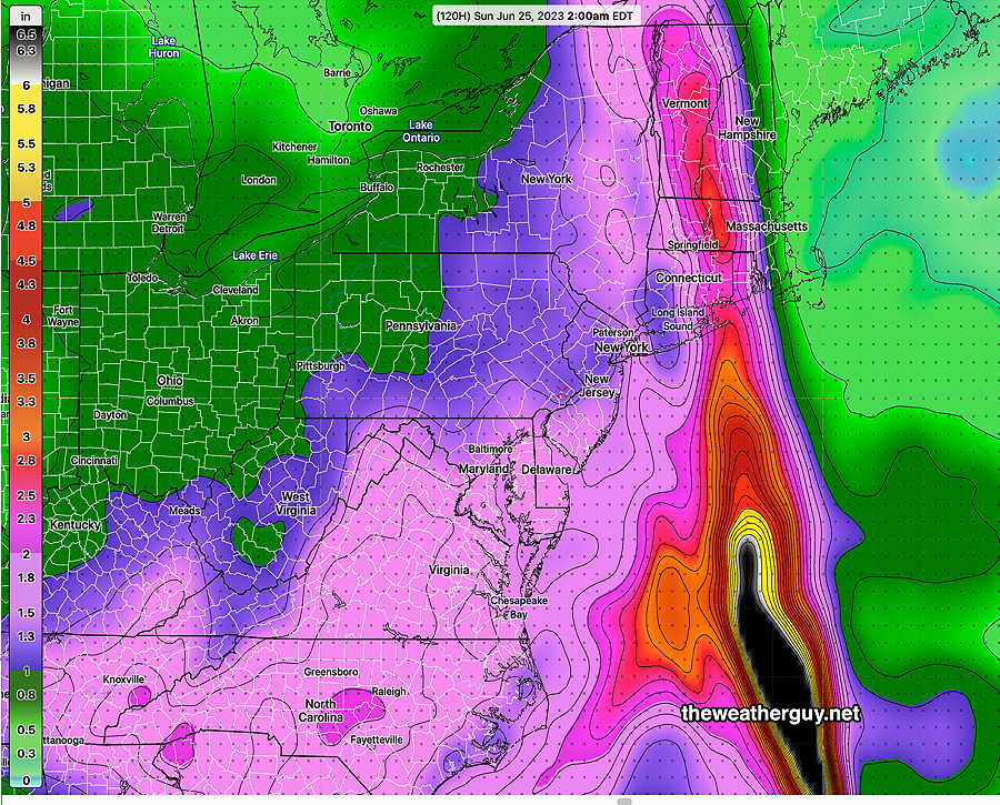
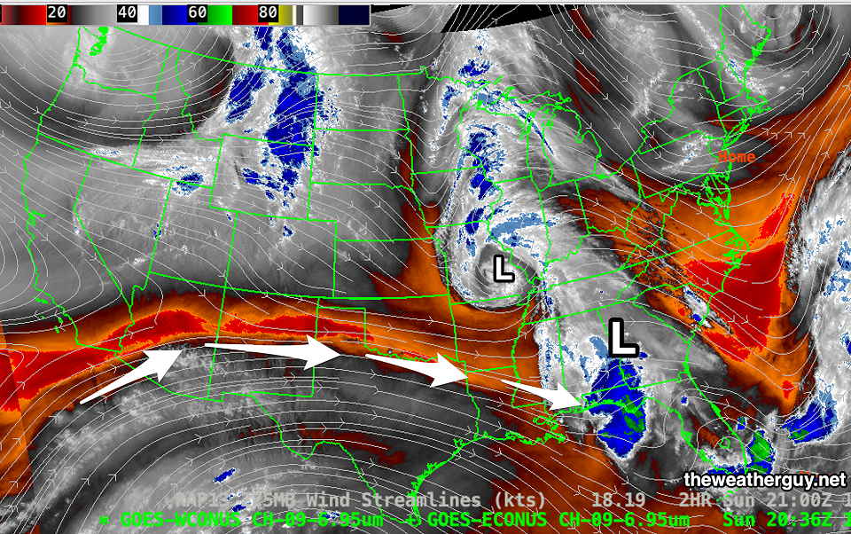
Update Fri 06/23 @ 9:05 AM —Last night’s model’s promise of rain and storms this morning have materialized, but not in the location that had been forecast. The immediate Philadelphia area and Delaware Valley have missed this round of showers. It’s currently raining in South Jersey. An analysis of latest RAP model and water vapor image shows the maximum Vertical Velocity Pressure (“PVV” – also referred to as Omega, not to be confused with the block Omega) is occurring in NJ, not over Philadelphia— Last night’s models continue to show a likely maximum in showers and thunderstorms about 1-3 PM today. Can we believe it? I’m always looking for some model clue that would give a better forecast. One of last night’s models does show a forecast of the thundershowers in NJ, based on its forecast location of maximum negative “Showalter Index.” (A old classic meteorology index of atmospheric instability). The Canadian high resolution model includes the Showalter Index. Here’s it’s forecast for the Showalter Index corresponding to the above time frame — If the Showalter Index is any secret sauce for predicting the thunderstorm placement for this afternoon, look towards Collegeville at about noon to 2 PM. If this doesn’t work, I don’t have any answers to get a handle on this weather system. Update Thu 06/22 @ 7:33 PM — Since Tuesday, I’ve been saying the model forecasts haven’t been doing too good a job. After having posted several “total rain accumulation” forecast maps over past days, one should be wondering, ‘where’s all that heavy rain?’ Here’s the MRMS rain gauge/radar measurement of the rain we’ve received over the past day or so. We haven’t received much— A warm front is is still expected to move north of us on Friday, with a shift to southerly winds and greatly increased humidity/dew points. Some models suggest a possibility of some showers after midnight tonight with most predicting scattered thunderstorms around daybreak and from noon on Friday through the evening. Some of the severity parameters, particularly CAPE, are moving into the high range tomorrow. Some of the thunderstorms could be moderate to severe. It’s currently expected that much of the heaviest rain will move just to the west of Philadelphia. Western suburbs should get the most. Since none of the models have been correct about any of this, I’m not going to post another precip map tonight. Update Thu 06/22 @ 8:58 AM — My update from last night still holds. Here are some additional insights— I’ll be trying to narrow down the timing and the weekend forecast later today. These upper air low based forecasts can be challenging. Update Wed 06/21 @ 8:01 PM — The rain moved in about 6-8 hours earlier than had been forecast last night. The rainfall has been much less than predicted and total rainfall through Thursday morning will be less than 0.5 inches in the overall Philadelphia area. Some models show the axis of heavy rain to occur along the Jersey shore. Not sure if that will hold true. This has already been one of those systems that make weather prediction frustrating rather than satisfying. Having looked over most of today’s models, here’s the best forecast I can infer from them for the Philadelphia area/Delaware Valley — With this system, I won’t even attempt a forecast for Saturday at this time. Update Wed 06/21 @ 11:20 AM — As mentioned in my forecast review yesterday, the sunnier conditions than forecast on Tuesday suggested that the models are not capturing this weather event well. This morning’s radar is another sign that this event is not being modeled well. The advancing rain line from the south is well north of what was forecast, even by this morning’s models— Update Wed 6/21 @ 7:35 AM — No change from last night’s forecast update. Rain moves in from the south between 8 PM and 11 PM this evening. The latest ECMWF model shows a negatively tilted upper air trough develops to our west over the weekend. Rain is possible at least through next Tuesday! The rain will not be continuous. Best chances for a break in the action are Thursday afternoon (Phillies game) and Sunday morning. Otherwise, rain, scattered showers and thunderstorms likely. I’ll update later. Update Tue 06/20 @ 8:28 PM — Today’s models continue with the forecast of rain moving in from the south Wednesday evening, about 8PM to 11PM and continuing on and off Wednesday night through Saturday. It will not be continuously raining and breaks of sun during the daytime hours Thursday, Friday and Saturday will lead to thunderstorms developing due to an unstable atmosphere and upper air cyclonic flow. Exact timing of the rain will have to be determined day by day, since no model can accurately time the dynamics of this complex system too far in advance. The current total precipitation amounts and placement varies from model to model, but here’s the latest HREF model forecast captures the current rainfall forecast through 2PM Thursday— The latest RAP model has a similar forecast rainfall as the latest GFS (not surprising since the RAP model uses the same input data setas the GFS) and is less than the above HREF forecast— I’m sure these forecast amount will change by tomorrow! I’m going to be waiting for a few more models to come in before updating my forecast. Check back later this evening. Update Tue 06/20 @ 9:54 AM — Most models have the rain advancing into the Philadelphia area around 9 PM – midnight Wednesday evening. There’s a divergence in the models for the track of the heaviest rain, with some keeping it offshore near the NJ coast, while others keep a swath of heavy rain moving right up through the Delaware Valley. So we may get as much as 2+ inches of rain (NAM-NEST) here, or maybe closer to an inch or so. The latest higher resolution GEFS is leaning towards 1.2″ by Sunday— Update Mon 06/19 @ 5:30 PM— The high cloud cover that moved in today is from the system in the Southeastern US. The models continue with their trend towards significant cloudiness on Tuesday. There is a chance of some light sprinkles Tuesday night, mostly areas near Delaware and far southern NJ. Wednesday looks to be cloudy. There’s a chance of light sprinkles during the day, but most models have any rain moving in slowly about 11 PM Wednesday into Thursday morning. Thursday— Depending upon the position and degree of strengthening of the upper low, Thursday through at least Saturday look wet! Details of whether the rain will be the results of showers, thundershowers or a mix is not clear at this time. After weeks of dry conditions in May into early, who would think we’d be talking about the possibility of consecutive days of rain the third week in June? Update Mon 06/19 @ 8:43 AM — Cloudiness from the southern system was expected this week, limiting high temperatures. But it looks like the upper low and associated surface low in the Southeastern US will intensify enough to send more than just clouds northward. The GFS (but not the NAM) is showing showers moving northward towards us as early as Wednesday afternoon or evening. The NAEFS (which includes the GEFS) also shows light showers by 2 PM Wednesday, especially southern areas— Some cloudiness (high cirrus clouds) associated with this system will move in as early as this afternoon (Monday.) Tuesday will have varying degree of cloudiness. Updates this evening. Previously Posted Sun 7:54 PM — The blocked pattern that gave us the dry weather during the previous many weeks has re-established itself, this time with the center of the block shifted somewhat eastward. The current pattern also differs from the previous block because a strong southern jet stream is flowing through the southeastern US, bringing moisture and heavy rain to that region. A closed upper low is expected to transform into a closed upper and surface low over the southeastern US and southern Appalachian mountains. Some of the moisture associated with the southern jet and the closed upper low will rotate near us during the week into next weekend. We’ll see it in the form of a southerly to southeasterly surface wind flow and varying amounts of upper and mid level cloudiness. Any rain will likely wait until next weekend. Additionally, as the upper low in southeastern Canada moves slowly away, we’ll see increased humidity and increasing temperatures by the end of the week, dependent upon the cloud cover. A lack of clouds and a southerly/southeasterly wind flow will bring fairly summer-like temperatures to our area on Monday (Average seasonal high is 83º to 84º this week.) — Due to the increase in cloudiness on Tuesday and beyond, Monday may be our warmest day for several days.Friday’s Updated Forecast

Friday Forecast
Thursday-Friday Forecast Update
Rain Forecast Update
Rain Forecast Update
Wednesday – Friday Rain Update

Rain Update
A review of the experimental RRFS-A model is similar to the above. Updates this evening.
Outlook Update

A Change in Forecast

Weather Overview
Monday