
#weather #paweather #wx #pawx #philadelphia #phillywx
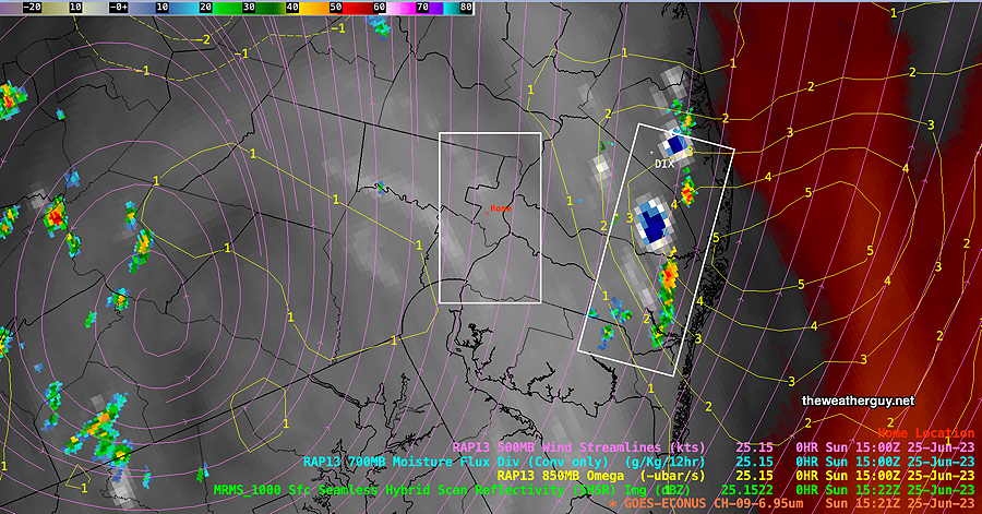
As a followup to the discussion earlier, here’s the earliest signs of the storm development at 10:21 AM today—

At 10:22 AM, storms developing in NJ—
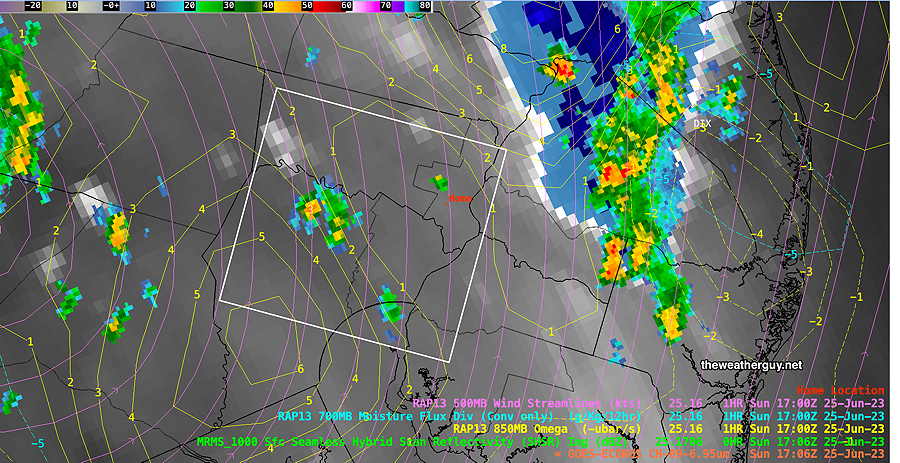
At 1:06 PM, the storms are still over NJ, but storms are popping up in Chester county. The RAP model shows positive Vertical Velocity Pressure in Chester county.
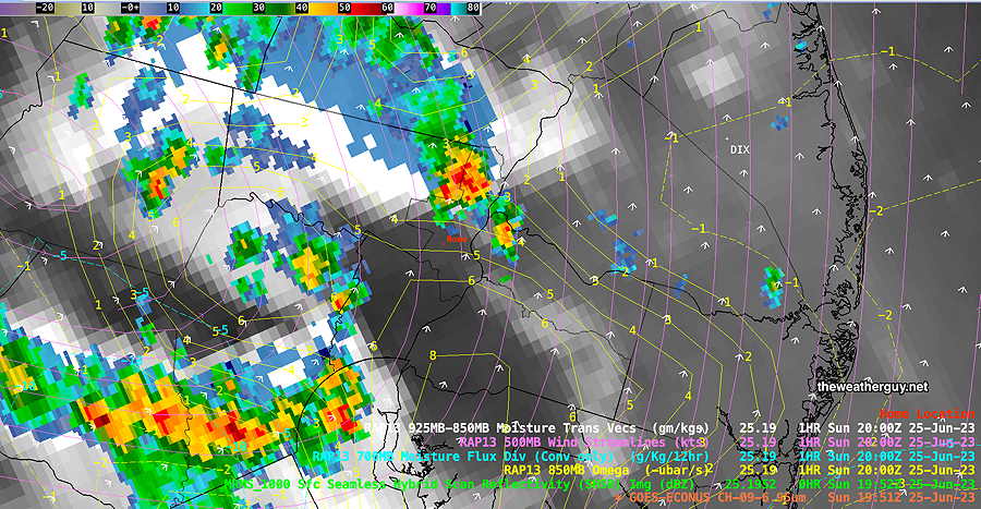
At 3:52 PM—
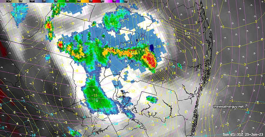
At 5:40 PM, active storms still developing as I type this, but the storms in the immediate Philadelphia area are moving into an area of negative Vertical Velocity Pressure and should diminish in intensity. The storms in NJ are poised for intensification—
Sunday Forecast Update
Updated Sun 06/25 @ 9:03 AM — The HRDPS and latest RAP model have thunderstorms forming dynamically about noontime today. Most of the other models are forecasting storms developing around 2-6 PM.
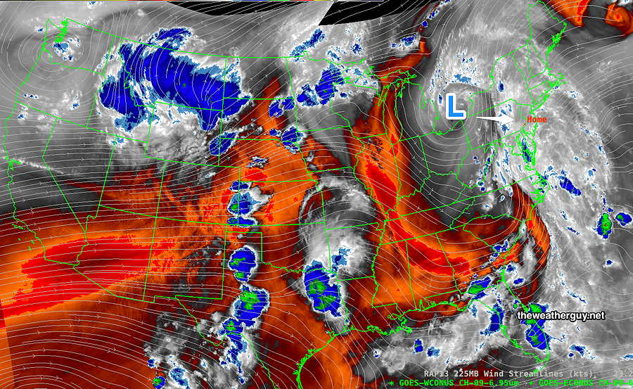
So which forecast, if any, can we hang our hat on? The first clue is to look at the current conditions, specifically the current satellite water vapor image (Channel 9). Is there any disturbance visible that will move in about 3 to 4 hours?
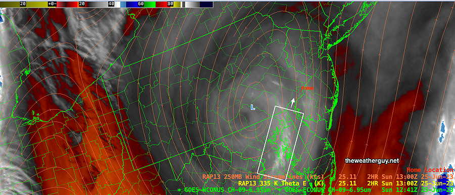
Satellite Water Vapor images are different than visible cloud images. Water Vapor images show the temperature of emitted infrared radiation, instead of the reflected light from clouds in visible satellite imagery. In this image, whiter and in some cases blue areas, show the highest and therefore coldest “effective level” of the water vapor layer. Colder effective layers are indicative of rising motion. (Click on image for a larger view.)
In the above image, we see an area of colder (whiter) effective layer, suggestive of the spark for thunderstorm development. This area is right over Chesapeake Bay, about 2-4 hours away by jet stream winds, currently at 30 mph in this region. (The one thing not in favor of this forecast: the upper air area is not as developed as it might be. The blue areas in the lower right corner are examples of much more developed upper air disturbances.)
So the noontime to1 PM forecast may be correct. Let’s see. This is the fun of weather forecasting.
Sunday Forecast Update
Updated Sat 06/24 @ 10:53 PM — We had the majority of the rain late morning and early afternoon. The forecast for a 3-5 PM peak in thunderstorm activity didn’t occur around Philadelphia, despite almost every model having predicted it. The NBM thunderstorm prediction was all wrong.
If we go with today’s relative ‘winner’ in the forecast timing of the today’s showers, it would be the HRDPS. So let’s go with it for Sunday.
The latest HRDPS shows showers beginning to pop up around noon Sunday with a relative peak between 1 PM and 4 PM. The showers will be scattered and like today, there will be periods of sunshine interspersed. It will be much warmer Sunday with highs around 85º but with a larger than usual uncertainty of about ± 3º.
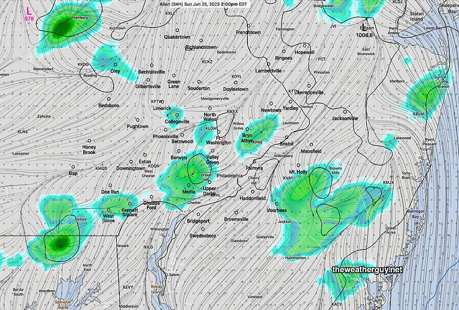
Here’s the HRDPS forecast for 2 PM Sunday—
Saturday Forecast Update
Updated Sat 06/24 @ 10:55 AM — It’s pretty clear, based on current radar and this morning’s models, that showers and thundershowers are forming now (late morning) and more numerous showers and storms are expected over the next few hours.
I guess last night’s HRDPS was correct with its forecast of earlier storms. None of these are expected to be severe (low shear low helicity)
Saturday Forecast Update
Updated Sat 06/24 @ 8:40 AM —The main area of rain from last night has departed to our northeast. Another area of enhanced moisture is in West Virginia and will rotate into our area this afternoon. Combined with the cyclonic flow and some breaks of sun, thunderstorms are expected to form this afternoon.
Rainfall will not be as heavy as it was in some areas yesterday. (PWATS yesterday were in the 2.0-2.1″ range) Today’s PWATs will be closer to 1.6″
While we’ve seen it’s impossible to predict exact timing and placement of the rain, it appears that showers and thundershowers begin popping up about 2-4 PM today as the area of enhanced moisture moves in, based on the HREF. The Canadian HRDPS has some showers popping up earlier, just before noontime.
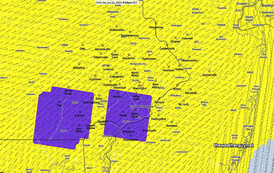
The NBM 4.1 model has a new parameter, thunderstorm coverage, which attempts to predict the areas/timing of greatest thunderstorm density. It pegs the period 3-5 PM as most active with the greatest areal coverage of thunderstorm activity as shown below—
Update Fri 6/23 11:39 PM — Additional high resolution models just available have showers and thunderstorms during the early afternoon as well as into the evening..
Update Fri 06/23 @ 9:59 PM — Tonight’s HRRR just available has considerable sunshine with clouds for us mid day and afternoon. Showers don’t move in until after 6 PM Saturday.
Previously Posted Fri 9:09 PM —
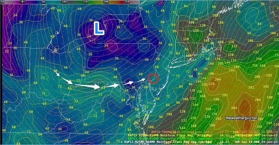
The closed upper low pressure system will move closer to us on Saturday through Sunday. As you can see from the water vapor image below, the ‘action’ with an upper low is often a certain radius away from its center; as it moves eastward over Pennsylvania on Saturday, we’ll still be in an unstable air mass, but much of the active moisture plume will move to our east. Nonetheless, instability will lead to scattered thunderstorm development.
Saturday
Cloudy and damp early. Breaks of sunshine expected during the day, interspersed with showers and thunderstorms— Showers and thunderstorms most likely during the mid to late afternoon. Look for updates for the timing of showers. Very humid with dew points in the low 70s.
High temperature 80.8º sd 2.5º ( NBM model— location Blue Bell, PA)
Sunday
Periods of sun and clouds. More cloudiness in the afternoon with a good chance of scattered showers and thunderstorms, especially after 2 PM and into early evening. High probability far northwest of the city. Still humid with dew points 68-70º.
High temperature 84.7º sd 2.6º ( NBM model— location Blue Bell, PA)