
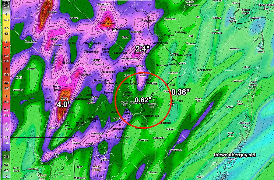
Rain Totals
Update Mon 06/12 @ 8:16 PM — The rainfall totals were somewhat similar to the model forecasts in a general way. The models captured the rapid decrease of rainfall in New Jersey and this morning’s emphasis on a westward maxima was somewhat correct. Even the rain maxima in Delaware county was somewhat captured, although no model had that rain location as the local maximum.
It was much needed rain!
While it’s still raining in Bucks county and northeastward, here’s the MRMS estimate of rainfall that fell today through 7 PM—
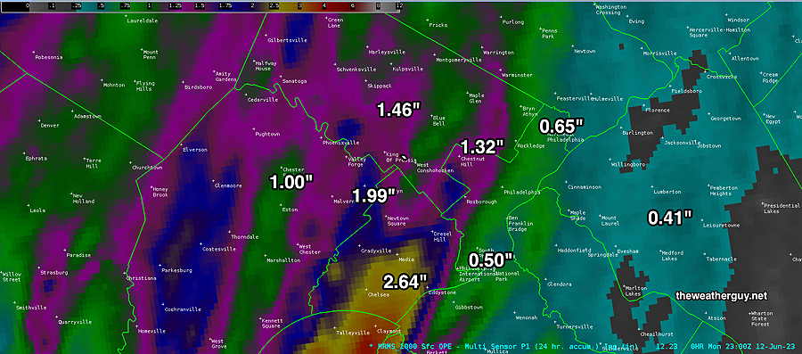
Good news…there’s more rain possible on Wednesday. More about that tomorrow.
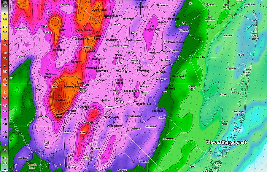
Monday Storm Update
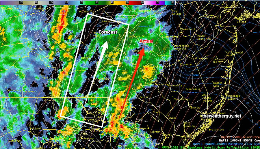
Update Mon 06/12 @ 4:02 PM — The rain arrived before 3 PM and the current radar suggests that the heaviest rain axis may be further east, through Philadelphia as forecast last night’s models, instead of a more westward track, as forecast with today’s models.
Demonstrating this is the current MRMS radar composite with superimposed vertical velocity pressure (white box) from today’s RAP model—
Generalized severe weather still doesn’t appear likely, but some severe localized cells always possible. We could definitely use the rain.
Monday Storm Update
Update Mon 6/12 12:54 PM — So my 12:12 update indicating a later start and a westward axis of rain appears to be an error of inadequate model spin-up time. I’m going to lean back towards the earlier model run forecasts with a 2-3 PM onset and heavier rains extending into Philadelphia. I guess we”ll see. We need the rain.
Update Mon 06/12 @ 12:12 PM —The latest models are moving towards a more westward position of the heaviest rain. Additionally, the rain is now expected to move in at 3-6 PM range rather than the earlier start time.
This trend is more in line with the GFS, ECMWF and ICON models, but I’m not sure if the change in the mesoscale models is just a manifestation of inadequate model spin-up time.
Here’s the latest HRRR precipitation forecast —
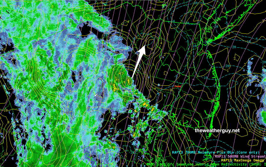
The latest live MRMS with superimposed RAP model moisture convergence and omega (vertical velocity) supports this westward emphasis—
Monday Storm Update
Update Mon 06/12 @ 9:08 AM — The trends listed last night continued with the 06z model runs early this morning.
There are large differences in forecast rainfall between the low resolution global models (which tend not to have explicit convection (thunderstorm) parameterization) and the high resolution mesoscale models which do.
This event will have significant convection and I’ll be leaning towards the HRRR, NAM-NEST, HRDPS and HREF models with explicit convection.
Timing: light showers, as forecast by the HRDPS yesterday are moving through the area this morning. Showers and thundershowers move in to western suburbs as early as 11 AM to noon. Heavier activity moves in 2-3 PM and continues with a peak between 5 PM and 7 PM.
Precipitation Amounts: Heavy rain from this system appears to be the major component. Here’s the latest HREF model total precip forecast, which is on the higher end of the HRDPS and HRRR—
Severity— As mentioned yesterday, the severity parameters are in the moderate range with some very localized moderate-severe in a few locations between 5-6 PM. Wind gusts are not forecast to be as high as other recent events. That doesn’t mean severe weather can’t happen. Overall, severity possibilities are lower than recent severe events.
| HRRR Severity Parameter | Sept 1 , 2021 Tornado Outbreak (example of highly severe) | Recent April 1st 2023 Tornadoes (Example of severe) | (06-12-23) Today’s 06z HRRR Forecast | Impact |
| CAPE Joules/kg | 3500-4200 | 900-1100 | 900-1100 | ⇩⇩ |
| Helicity m^2/s^2 | 1350 | 655 | 406 | ⚐ |
| Vertical Shear 1/sec | 40-46 | 40-45 | 18-20 | ⇩ |
| Precipitable Water | 2.7″ | 0.83” | 2.0″ | ⇑ ⚑ |
| Lifted Index º K | minus 6 | minus 9.3º | minus 3.3 | ⇩⇩ |
| HRRR Hail inches | 1.9 | 1.4 | 1.5 | ⚑ |
| Peak Wind Gusts mph | 40-50 | 40-50 | 35.5 | ⚐ |
| Storm Motion Shear Vector Alignment | Aligned – ~ 90º | Almost aligned | non-aligned | ↓ |
| 250 mb Jet Stream Wind mph | 63 | 135 | 42 | ⇩⇩ |
↓ indicates works against Severity ⇩ Significant, but less impact
Monday — Finally Some Rain!
Update Sun 6/11 10:54 PM — A quick update. Tonight’s early models have the following trends—
- High resolution models have the heavy rain through Philadelphia.
- Low resolution models keep the heaviest rain west of Philadelphia
- As forecast by the earlier HRDPS, some showers possible in the morning.
- Several models have the heaviest rain in the evening.
- Several models have significantly less rain in New Jersey.
Updates tomorrow morning.
Previously Posted Sun 5:56 PM —
Over the past week, the models have been advertising a significant rain event for us on Monday with a frontal passage. If nothing more, one should be impressed that this weather event has been consistently forecast almost a week in advance.
The real grit lies in the details, and there’s increasing evidence that much of the area will get 0.6″ to over 2.0 inches of rain, much more rain than most areas have seen in over a month.
As is often the case, the models’ grasp on the forecast severity parameters (vertical shear helicity CAPE PWAT Lifted Index ) tend to become more meaningful within 18- 24 hours of the event. That’s been the case with tomorrow’s event.
Here are the trends—
• There has been a general trend towards higher amounts of rain, both in eastern PA and NJ.
• There has been a general increase in what I call the severity parameters. However vertical shear values have remained at the low end.
• The actual cold front comes through about 9 PM (Blue Bell) but most of the rain comes well ahead of the actual front.
There’s still a range of model timing with the Canadian model having a line of thunderstorms move through as early as 11 AM to 3 PM, with a second line moving through about 6- 8 PM with the cold front.
Our NOAA models (e.g. HRRR) have scattered storms from about 2 PM through 10 PM with more emphasis on late afternoon and early evening for the heavy activity.
Latest HRRR—

Sunday afternoon’s HREF model—

Check back on Monday for updated forecasts and my “severity table”.
#weather #paweather #wx #pawx #philadelphia #phillywx