
#weather #paweather #wx #pawx #philadelphia #phillywx
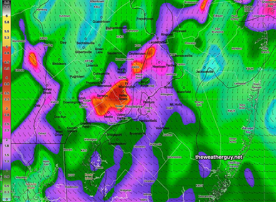
Here’s a MRMS based estimate of the rainfall received today—
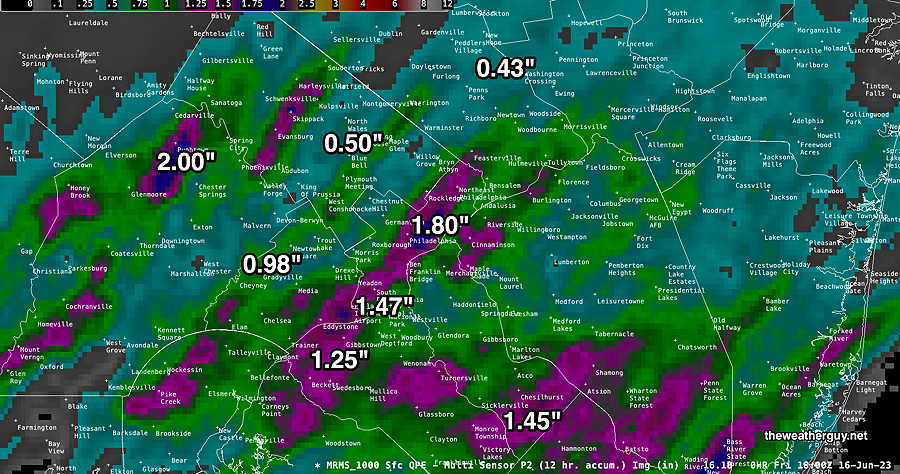
Update Fri 06/16 @ 1:28 PM — The rain moved in about 1 hour earlier than I had forecast.
Some additional showers possible later this afternoon.
An early look at the MRMS shows many areas in Philadelphia and eastward had 1-2″ of rain. The MRMS works on an hour so so delay, so I’ll post it later to provide a meaningful overview of the rain we received.
Live Blog Experiment
Today’s live blog was an experiment. It’s complicated to do and it won’t be a regular feature. But for some serious future weather events, I’ll consider activating it again.
Friday’s Storms
I’ve made several updates in a in short period of time today. You may need to refresh your browser to see the updates.
Update Fri 06/16 @ 9:28 AM —
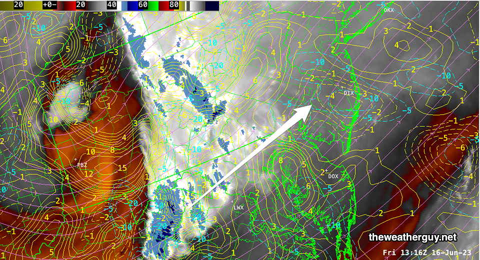
Latest water vapor image shows the upper air disturbance in West Virginia that will rotate into our area by 1 PM. Dotted blue contours show areas of maximum moisture convergence—
Update Fri 06/16 @ 9:24 AM — Latest HRRR (12z) just available shows 1PM maximum in instantaneous precipitation rate (PRATE) just west of Philadelphia —
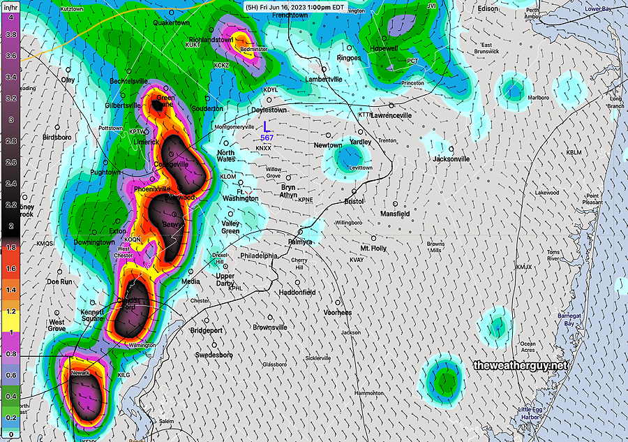
Update Fri 06/16 @ 8:28 AM — HRDPS forecast instantaneous precipitation rate at 1 PM—
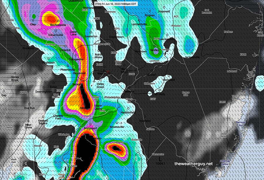
Update Fri 06/16 @ 8:16 AM — Current Radar with likely track of heaviest rain—
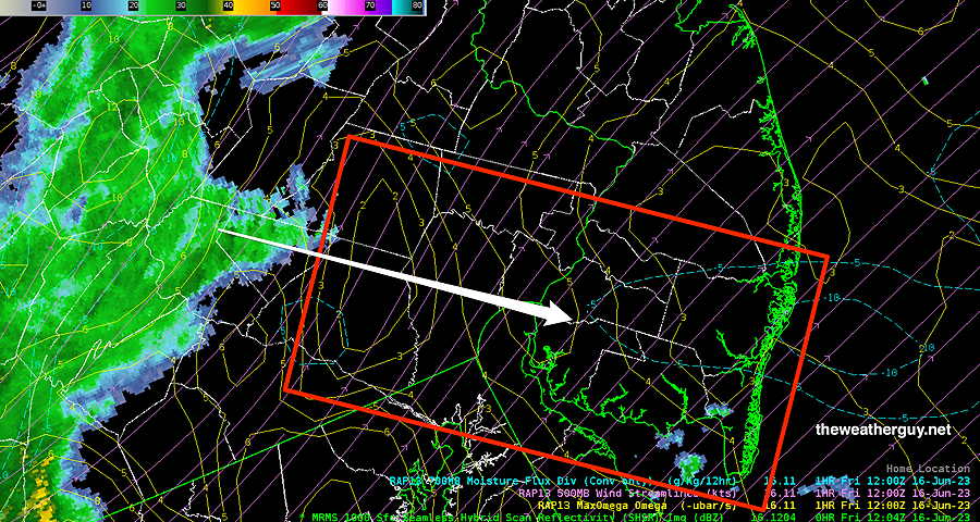
The latest HRDPS has joined last night’s HRRR in its forecast placement of the heaviest rain. It appears to be in South Jersey—

Updated Fri 06/16 @ 8:02 AM —Fast Update: Not much change in the forecast. There’s still lack of clarity regarding the exact location of the heaviest storms.
For Philadelphia and the immediate western suburbs, the 12-2 PM time frame appears to be the period of maximum storm intensity. A second batch of storms possible 5 PM to 9 PM. There seems to be some emphasis on maximum rainfall just east of the Delaware River into Southern NJ.
I’m preparing some graphics…more info coming.
Friday’s Storms Update
Update Thu 6/15 11:03 PM — No significant change from the earlier forecast. The action starts as early as 10-11 AM in the western suburbs. Peaks about 1- 4 PM. Tonight’s models haven’t made it any easier to identify the areas that will receive the heaviest rain. Six models, six areas forecast for the heaviest rain.
Trends— the storms may come through in two groups. PWAT values have increased. CAPE and shear values have also increased suggesting stronger storms.
Updates tomorrow morning.
Friday’s Storms Update
Updated Thu 06/15 @ 5:33 PM—
The high resolution models continue to forecast thunderstorms and rain for Friday, starting late morning (10-11 AM) in western suburbs and peaking between 1-4 PM in the city and adjacent areas of Southern NJ as a result of surface low pressure being spawned by an upper air low pressure system.
Due to low level moisture convergence, areas of very strong vertical motion and reasonably high PWAT (1.7″), the high resolution models crank out very heavy rainfall in some areas, on the order of 1″-3.5″.
(It should be noted that not all the models are predicting very heavy rain: the NBM and the GFS are showing as little as 0.4″ to 0.8″ of rain. )
As always, those models predicting the heavy precip differ in their forecast location of these heavier bands of rain. The HRRR has its maximum from the city eastward into South Jersey while the HRDPS and NAM-NEST have areas just to the west of the city receiving the heavier rain.
Much of this heavy rain will be the result of thunderstorm activity. While CAPE values are in the 1000 joules/kg range (moderate), moderately high levels of vertical shear (24-30/sec) and areas of low to moderate helicity (near 400), there is significant vertical motion dynamics forecast that will result in some strong, possibly severe storms.
NAM-NEST—

HRDPS—
The latest HREF, just available, probably captures the best compromise, but may still be over forecasting the rain—

Rain Friday, Possibly Heavy
Updated Thu 06/15 @ 9:03 AM —
The persistent upper low over eastern Canada is forecast to spawn a surface low near our area on Friday. It looks like rain moves in during the late morning.
The models continue to show low pressure that may cause heavy rain in the immediate Philadelphia area, starting late morning (10-11 AM) and lasting through the afternoon. Instability will add thunderstorms to the mix. Severity levels to be posted later today.
As is always the case with precipitation, the exact location of the heavy banding of rain/thunderstorms isn’t often captured accurately by the models. Over the past 12 hours, there’s been wide range of locations forecast to receive the heaviest rain. (On the order of 2-3 inches!)
I’ve recently been impressed with the Canadian models for this current weather pattern.
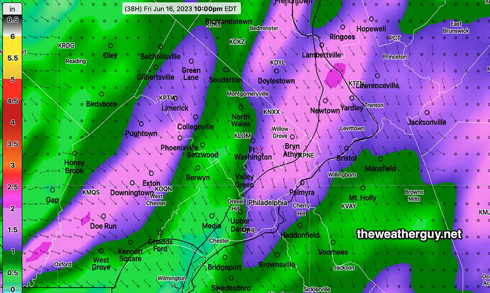
Here’s the latest Canadian HRDPS model forecast for total rainfall on Friday—
Updates later this afternoon.
Thursday – Friday Outlook
Update Wed 06/14 @ 4:31 PM— The system that moved through Wednesday was even slightly faster than the faster HRDPS had predicted. Sunshine broke out about 3-4 PM.
A beautiful day on tap for Thursday with temperatures 80º to 81º.
The persistent upper low over eastern Canada is forecast to spawn a surface low pressure system near our area on Friday. It looks like rain moves in during the morning.
This afternoon’s HREF and NAM-NEST are showing areas of heavy rain possible in and around Philadelphia. I’m not sure if that forecast will hold—

For Saturday, spotty instability showers possible during the afternoon.
Sunday looks sunny.
It looks like the blocked pattern will remain through most of next week. I know I said last week we’d get a weather pattern change by the the middle of this week, but I didn’t think it would be just an eastward shifted block. We have gotten a change in the weather this week with several days of showers and rain.
It now looks like the blocked pattern will flatten by the end of next week, according to the GEFS. Don’t hold me to it.
Wednesday Radar
Rain on the way. Total rainfall amounts expected to be about 0.25″ in most areas, with some localized higher amounts.
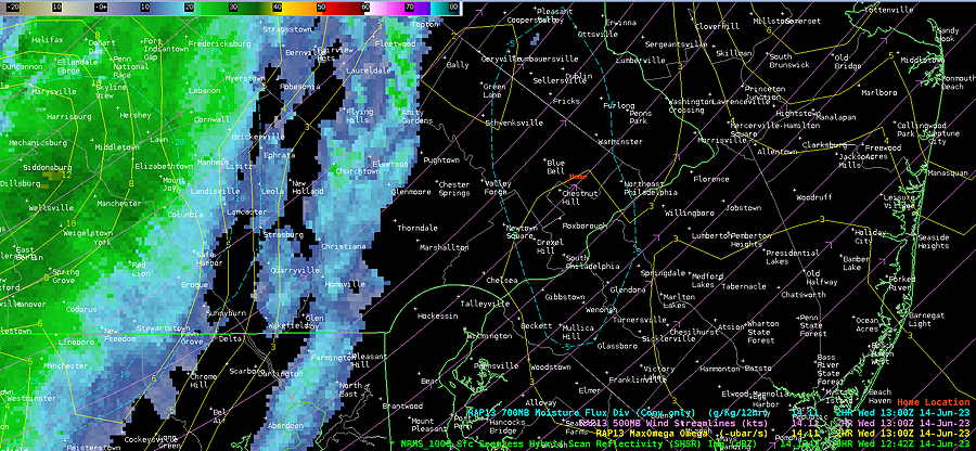
Current radar at 8:42 AM showing RAP model superimposed data—
Wednesday Forecast Update
Update Wed 06/14 @ 8:24 AM — The earlier noontime start to the showers now appears quite likely. In fact, some showers may move into western suburbs after 11 AM. There’s an increased likelihood of showers and some scattered embedded thunderstorms from 2 PM to 5 PM.
The latest HRDPS is faster with this system and has the much of the activity exiting by 4 to 5 PM with sunshine returning, while the NAM-NEST keeps some shower possibility until about 7-8 PM. I’m leaning towards the faster HRDPS.

Showers & Thundershowers Wednesday
Update Tue 06/13 @ 7:44 PM — An upper low in NY State (part of the new Omega Block) will rotate an mid level (500 mb) disturbance through the Philadelphia area on Wednesday. The upper disturbance will be enhanced by southern jet streak energy—

The combination of the jet streak energy, the mid level (500 mb ~18,000 ft) vorticity disturbance and thermal instability will set off scattered showers and thunderstorms.
Clouds move in late morning. Showers and some thundershowers possible as early as noontime, but most models have scattered showers and thunderstorms most likely at 4-5 PM and possible into the early evening. There will likely be some breaks of sun in the afternoon. Any sunshine will act as fuel for more thunderstorms later in the afternoon.
Right now, severity parameters appear to be mid level to low.
Yet Another Omega Block Ω
The forecast for this week has changed from just a few days ago. What had been expected to be a flattening of the long standing Omega Block has instead re-established itself with the block’s main axis shifted 30º more eastward than the previous block.
Additionally, a strengthening of the southern jet stream will introduce more moisture into our circulation than the previous several weeks. (The flattening of the block is now expected next week.)

What this means will be another week or so of cooler than average temperatures but with unsettled weather, and with a chance of more rain showers as low pressure at the surface develops where the northern and southern flows come together near the Carolinas—

Between the two low centers, a persistent trough will develop through our area, leading to the development of instability showers. We’ll see the first of these on Wednesday. Details later today