
#weather #paweather #wx #pawx #philadelphia
Friday – Saturday Update
Update Fri 03/31 @ 9:13 AM — The cloudiness is moving in as expected and the rest of Friday will be cloudy. No rain expected in our area until around or after midnight.
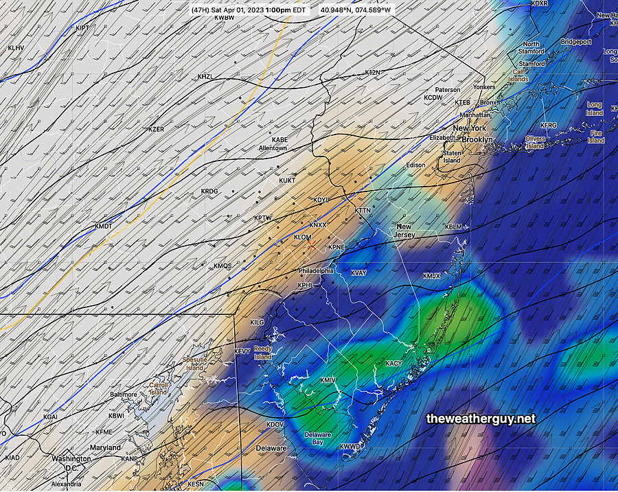
For Saturday— rain in the morning with a sharp clearing line moving through from west to east about 1-2 PM. It now appears that the second line of showers moving through about 5:30 – 8 PM will have the possibility of strong (not severe) thunderstorms, especially from Philadelphia and eastward into NJ.
I’ll update this evening with my regular Weekend Weather Forecast.
Friday – Saturday Update
Update Thu 03/30 @ 7:34 PM — A major low pressure system approaches and moves through the Great Lakes and Canada. Some changes in the forecast. Friday may have some early sun, but thickening cloud cover by late morning and the rest of the day. Temperatures will actually warm as the day progresses with highest temperatures towards evening.
Most models have the rain now starting somewhat earlier on Friday than previously forecast and have the rain move in about 7-10 PM, but the NAM and NAM-NEST have the showers moving in during the mid afternoon. These models appear to be outliers right now.
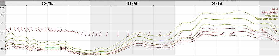
Heavier rain on Saturday morning still appears to abruptly end about 1-2 PM with the sun breaking out. (The ECMWF keeps shower around; I’m not going with that.) Some additional showers expected with the actual cold front moving through about 5-8 PM Saturday. It will be VERY WINDY on Saturday and high temperatures will be in the low 70s.
Thursday- Forecast Saturday Outlook
Update Wed 03/29 @ 8:42 PM — A cold front comes through tonight. Thursday will be sunny but chilly.
Friday: A major low pressure system approaches and moves through the Great Lakes and Canada. Increasing clouds on Friday. Rain begins around midnight.
Saturday: Rain in the morning. Rapid clearing about 1 PM. Very mild but extremely WINDY. High 72-75º. Another line of showers may move through about 6 PM Saturday evening with a sharp cold front.
Wednesday Forecast
Update Tue 03/28 @ 7:30 PM — High pressure builds in for mostly sunny skies on Wednesday. Some cloudiness mid to late afternoon ahead of a weak cold front and moisture aloft approaches. Highs mid to upper 50s.
Showers with the cold front are forecast to stay to our north Wednesday night.
Thursday looks a bit cool again.
A warm front moves through Friday. Just clouds expected with the warm front. Rain arrives late afternoon Friday or Friday evening. The rain may depart early Saturday afternoon (GFS) or linger longer (ECMWF).
Tuesday Forecast
Update Mon 3/27 11:28 PM — Tonight’s high resolution models show some light showers possible Tuesday morning
Update Mon 03/27 @ 8:20 PM — The showers moved in about 3 PM and the heavier rain moved in about 5 PM.
A front moved through today and cooler air on northwest winds will bring temperatures down the lower 50s on Tuesday. A few upper air disturbances will also bring considerable periods of cloudiness.
Dry conditions expected through sometime on Friday.
Update Mon 03/27 @ 9:59 AM — Last night’s models suggest the rain moves in later today, closer to 5 PM closer to 4-5 PM.

A series of low pressure systems will affect our weather over this coming week.
Rain from the first system moves in between 2 and 5 PM Monday. The GFS and RAP hold off the rain until after 5, but the majority of the high resolution models bring the rain in earlier, about 2 PM. (Still earlier in western areas)
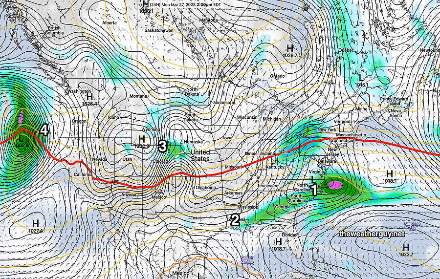
Another system (2) looks to be to our south on Tuesday. A weak cold front (3) moves through late Wednesday. By Friday afternoon, a large system (4) may affect us through Saturday.