Of course, Sunday morning is the beginning of Daylight Saving Time. I love the extra daylight at the end of the day, but for “weather nerds”, Daylight Saving Time means the models come out an hour later. For those of us on EasternTime, the evening models become available inconveniently late for the next day’s forecasts!
I’ve written extensively about this in past years—
A cold sunny morning, with possibly a period of cloudiness mid morning, will give way to an upper air disturbance bringing considerable cloudiness mid afternoon Sunday. There’s a chance of a quick snow flurry late afternoon or evening. It will remain unseasonably cold but less windy. High temperature 35º ± 1.7º
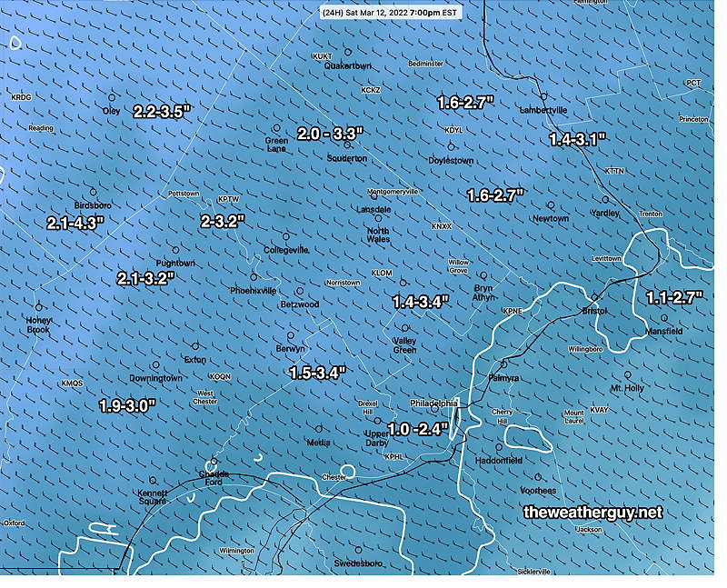
Update Sat @ 2:46 PM —Some flurries and snow squalls on the way. The latest HRRR shows possibly another inch of snow!
Sat 12:14 PM Forecast Review —The snow will be tapering about 1-2 PM, earlier than predicted. Just flurries possible. A storm whose forecast onset kept being moved to an earlier start, kept accelerating. A faster moving storm.
Snowfall accumulation amounts have been at the lower end of the forecast range. Looking at yesterday’s models, the CMC-RGEM and German ICON had predicted the lower snowfall in the range we have received.
Last night’s GFS/NAM/HRRR and HIRESW models over-predicted accumulation. The NBM forecast, which “blended” all of them, did pretty good, maybe a bit too high.
Here’s official NWS snow totals—
...Bucks County...
Chalfont 1.7 in 1231 PM 03/12 Trained Spotter
New Hope 1.5 in 1145 AM 03/12 Trained Spotter

...Chester County...
West Caln Twp 3.0 in 1226 PM 03/12 Trained Spotter
Malvern 2.7 in 0122 PM 03/12 Public
2 WNW Phoenixville 2.5 in 1223 PM 03/12 Public
East Coventry Twp 2.0 in 1200 PM 03/12 Trained Spotter
Phoenixville 1.5 in 0145 PM 03/12 Trained Spotter

...Delaware County...
Boothwyn 0.5 in 1200 PM 03/12 Public


...Montgomery County...
New Hanover Twp 3.5 in 1233 PM 03/12 Trained Spotter
Trooper 3.2 in 1050 AM 03/12 Public
Norristown 3.1 in 0130 PM 03/12 Trained Spotter
East Norriton 1.3 in 1215 PM 03/12 Trained Spotter

...Philadelphia County...
Phila Int Airport  Trace in 0100 PM 03/12 ASOS
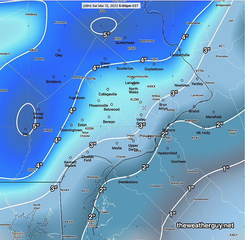
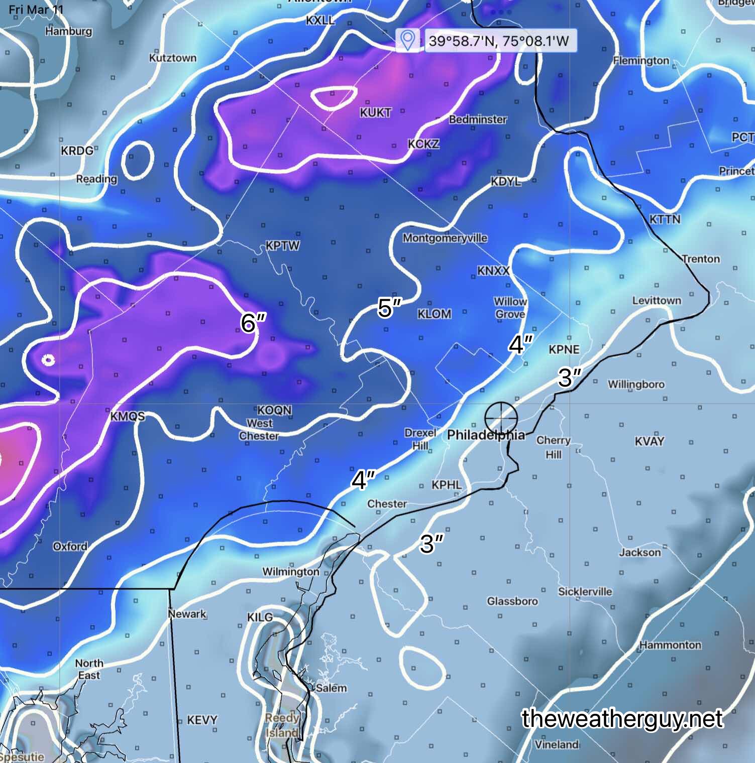
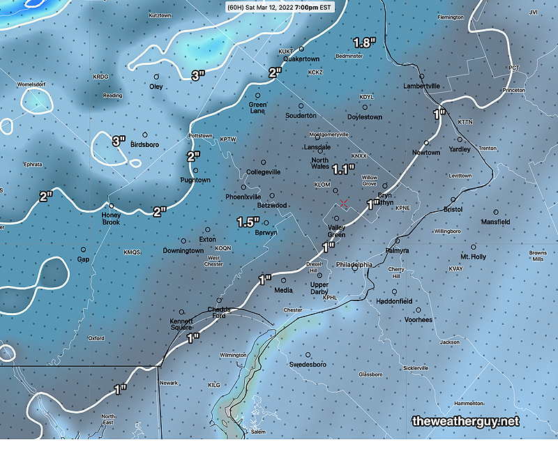
Update Sat @ 9:00 AM — The latest 12z NBM snow forecast—
This morning’s 12z NBM just became available. Notice the range of the spread has decreased and overall totals have decreased. (Click on image for a larger view.)
As of 9 AM, the precip is already changing to graupel (frozen melted snow) and the winds are picking up.
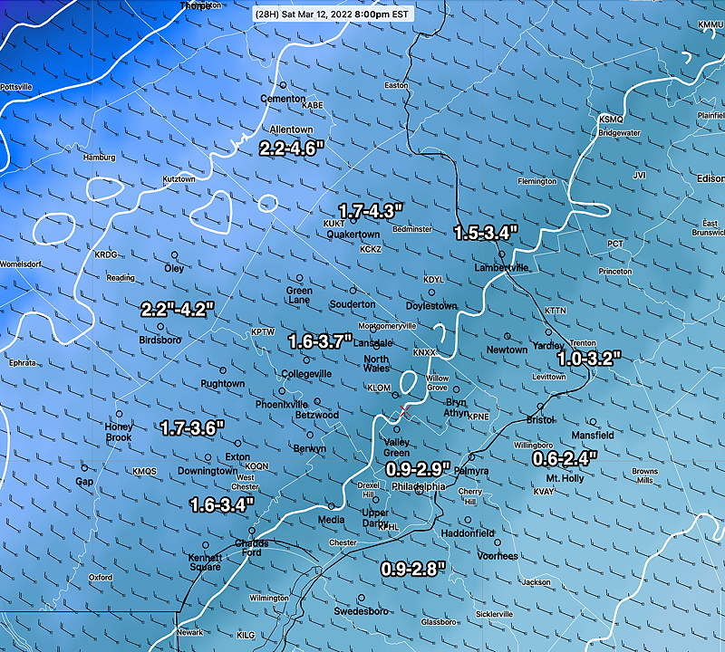
Update Sat @ 7:28 AM — Last night’s 1AM model runs (06z) have moved towards the mid and lower end range of last night’s NBM forecast. The general range still looks good. Expect the winds to pick up dramatically with the temperature drop between 9 and 11 AM.
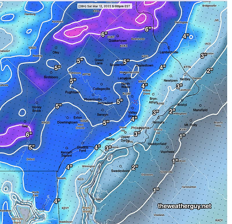
From last night — 00z NBM (25th through 75th percentile) snow accumulation. Likely accumulation tomorrow. Many models have leaned towards the higher number. (Click on image for a larger view.)
Update Sat @ 7:01 AM — I removed an update made at 11:47 last night. ‘Never try to do weather forecasting in bed with an iPad’.
Update Fri @ 10:16 PM — No significant changes with tonight’s models; the usual range of snow totals, similar to those posted earlier.
Rain changes to snow between 8 AM (western suburbs) and 10 AM (just west of city) to 11 AM (Philadelphia) and tapers to flurries between 3 and 5 PM.
Warm ground and March’s high solar angle will interfere with accumulations at start and likely reduce accumulations on roadways.
There will be some compression of initial snow due to wetness. With temperatures dropping and water-snow ratios changing in time, I don’t know that any model algorithm will be able to accurately capture this event’s snow totals.
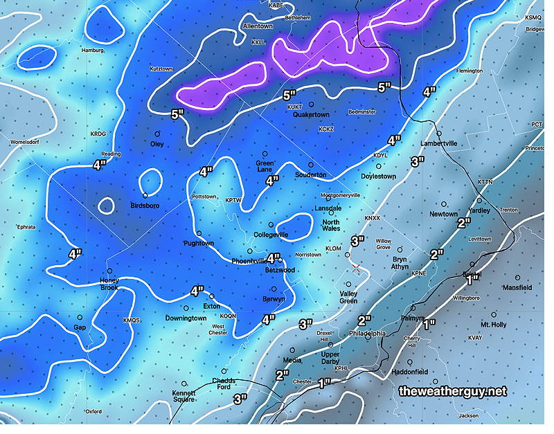
That said, I’m turning it over to the NBM (model blend). With a two inch spread, I think the graphic below will do the best, but keep in mind that some models have much more and and a few have less—
00z NBM (25th through 75th percentile) snow accumulation. Likely accumulation tomorrow. Many models have leaned towards the higher number. (Click on image for a larger view.)
Previously Posted Fri 6:03 PM —
The potential for a weekend storm was mentioned last Sunday and the evolution of the forecast for this storm has been ongoing with Wednesday’s post.
The trend has been for an quicker and colder storm with rain turning to accumulating snow. While there had been little accumulation originally forecast, all of the models last night began showing some accumulation.
Temperatures drop from 45º after midnight to below 32º by 9-10 AM, according the latest GFS.
Today’s trend towards increasing snow totals has continued. The reason: increased forecast total precipitation, a faster moving storm and cold air entering as early as 9-10 AM in Philadelphia and 7-8 AM in western suburbs. That’s about 3 hours earlier than previously forecast last night. Forecast QPF is as high as 1-2 inches of water, compared to the previously forecast 0.6 inches.
Part of the cooling allowing for the rapid transition to snow will be the result of a phenomenon known as dynamic cooling— heavy precipitation causes cold air to be brought down from the upper levels and phase changes and evaporative effects also chill down the atmosphere.
Here’s the latest GFS snow totals —
Today’s 18z GFS forecast snow totals by 5 PM Saturday. The numbers refer to the contours. Example: If you live in Betzwood, the amount about 3.5″. (Click on image for a larger view.)
Today’s 18z NAM-NEST. The higher resolution NAM-NEST along with convective physics allows it to forecast banding of snow, areas of higher snow totals. (Click on image for a larger view.)
As is often the case, the NAM and NAM-NEST forecast higher amounts than the GFS. Often an average of the two is a good guesstimate.
Sometimes, it’s best to let the Model Blend (NBM) do all the heavy lifting. Here’s the NBM 25th percentile through 75th percentile snow forecast—
It will become very WINDY. Sustained winds of 20 mph with gusts 35-40 mph forecast.
So where are the uncertainties? Well, the 12z ECMWF still has temperatures dropping a few hours later, although the 18z ECMWF hasn’t become available yet.
The ICON is forecasting only 1.2 ” where the GFS is forecasting 3″
The 18z Canadian GEM has a similar forecast as the ICON.
Previously Posted Fri 6:03 PM —
Sunday Forecast
An upper air disturbance will bring considerable mid-level cloudiness on Sunday. Some sun also expected. It will remain breezy and unseasonably cold. High temperature 35º ± 1.7º
Update Fri @ 10:08 AM — The latest NAM-NEST snow forecast, showing the high snow banding just west of Philadelphia. Exactly where banding will set up is not often very precise.
Today’s 12z NAM_NEST forecast (Click on image for a larger view.)
Additional Update Fri @ 9:00 AM — Some of the early morning models just coming in. The model blend (NBM) has moved to a 1.7” snow total as a 50 percentile value. (Half of the models comprising the blend are above this amount, half are below.)
One thing to keep in mind is the snow will fall at the height of the day in March, with a strong solar insolation effect through clouds; the sun angle is high this time of year. ) With the ground warm from Friday, I think most of the accumulation will be on grassy surfaces, not dark asphalt roadways. Some of that will be also influenced by the precipitation rate; high rate, more accumulation on roadways.
According to the NBM, the rain will start as early as 3 AM and the transition to snow between 11 AM and noon, earlier west of Philadelphia. With the earlier start, it will end about 3-4 PM.
Update Fri @ 8:13 AM — Last night’s models have all shifted their forecast towards snow accumulations in the immediate PHL area with Saturday’s storm.
The NAM, NAM-NEST, GFS, ECMWF all show at least 1” of snow in the immediate PHL area. Several of the HIRESW models and the HRRR are predicting several inches!
HRRR snow forecast for Saturday. The HRRR is in the upper range. It’s predicting banding of snow to occur just west of Philadelphia.NAM model forecast snow accumulation. (Contours are labeled. Each contour is 1 inch)GFS snow accumulation.
The trend has clearly moved towards an earlier start and a colder storm. I will update later this afternoon.
Update Thu @ 10:45 PM — Tonight’s models continue with the trend of a faster moving storm with cold air entering earlier. The NAM-NEST has reverted to its earlier accumulating snow forecast of 1-2 inches of snow and the model blend NBM, ECMWF, HRRR and HIRESW also show accumulating snow in similar ranges.
NAM-NEST
The NAM and ICON show only a coating. So uncertainty remains with this storm. Too soon to invoke “never ignore the NAM”.
I’ll update tomorrow.
Update Thu @ 5:35 PM —This afternoon’s models have trended towards little or no accumulating snow in the general Philadelphia area.
The storm is expected to move more rapidly than previously forecast. The actual cold front will move through early, 9-10 AM with heavy rain and with a shift in the winds to the NW.
There has also has been a general trend for temperatures to drop below 32º a bit earlier, now sometime between noon and 2 PM.
Coinciding with that temperature drop will be a transition from rain, briefly to sleet, and then snow showers before ending about 6 PM. Still expect WINDY conditions.
Another change for Sunday— The ECMWF shows an upper air disturbance moving through Sunday afternoon with clouds and some snow showers possible. The GFS just has clouds.
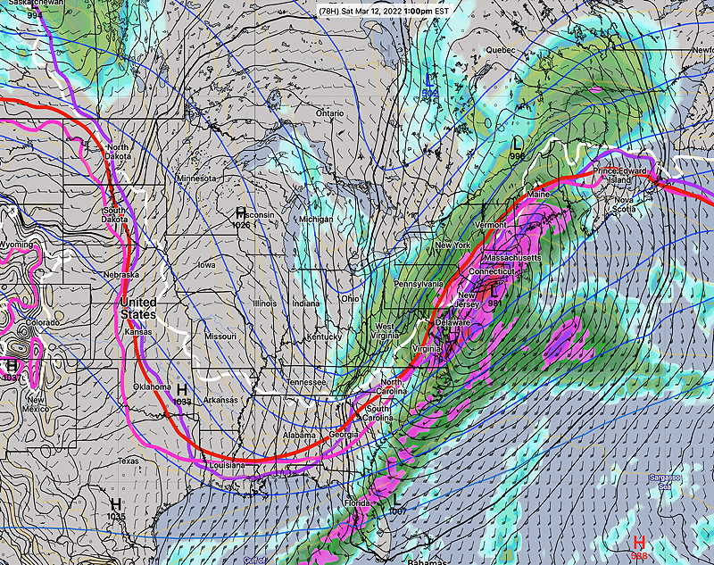
Update Thu @ 10:06 AM — Saturday continues to look like a stormy day, with the coastal low forecast to deepen below 970 millibars (that’s hurricane level low pressure) by the time it gets to Maine.
Rain should begin about 6 AM Saturday morning. Right now, just a moderate rain is expected during the morning hours (less than 0.5″ water). The big issue will be wind and rapidly falling temperatures, with highs near 50º early morning falling below freezing by 2 PM and into the 20s by evening.
A changeover to some snow is expected between 1 and 2 PM. There’s a lot of model uncertainty regarding any snow accumulation with the SREF showing a mean snowfall (Blue Bell) of 2 inches but the range is anywhere from zero, a grassy coating, to over 2 inches.The RGEM and GFS are showing little to no accumulation. Too early to predict now, but rapid icing is possible on some surfaces.
Snow flurries end about 6 PM.
Here’s the latest NAM-NEST snow accumulation forecast which is on the high side of things—
NAM-NEST Snow accumulation forecast for Saturday 7 PM. (Click on image for a larger view.)
High winds of 20 mph sustained with gusts to over 30 mph. The only good thing about the winds is that it might dry surfaces before too much icing occurs.
Sunday, first day of Daylight Saving Time, looks sunny and unseasonably cold. Windy. High just 37-38º
Previously Posted Wed 8:17 PM —
Generally moderating temperatures expected Thursday through early Saturday.
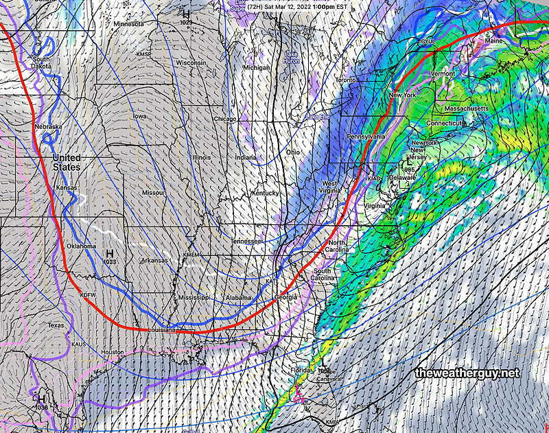
A very strong coastal storm is expected to develop and move northeastward on Saturday, as much colder air moves down causing a dip in the jet flow.
The general forecast path of this storm has trended somewhat closer to the coast over the past several days, with a mostly rain event as warmer air will move in with the system. As the system moves away, there is a possibility that there will be change to snow as very cold air moves in behind the low. Very WINDY conditions developing.
The ECMWF and GEFS models are in pretty good agreement with the speed and path, but the ECMWF and GEFS have a more eastern track than the NAM —
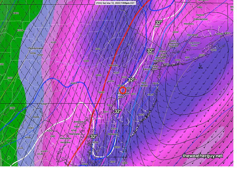
ECMWF forecast for 1 PM Saturday. Low pressure just south of Long Island with significant wrap around precipitation. West of the (red) “540 thickness line” will be snow. Notice the surface freezing line (white) is just passing through Philadelphia around 1 PM. (Click on image for a larger view.)NAM Forecast for 1 PM Saturday. Notice the (red) “540 thickness line” is further west with the low further west, indicating a warmer storm and mostly rain as the main body of the precipitation. (Click on image for a larger view.)
Zooming in, this time with the latest GEFS which like the ECMWF also has a colder eastern track, we can see that it’s predicting a drop to freezing about 1 PM with a changeover to snow shortly thereafter.
GEFS (mode forecast) shows the surface freezing contour (white) moving through Philadelphia about 1 PM, with the 540 thickness line not far behind, suggesting a changeover to some snow. (Click on image for a larger view.)
(I should mention that the latest ICON model is very different. Not sure if it’s significant.)
Warmer temperatures preceding the storm along with high sun angle (it’s March) suggests low ability for snow to accumulate, especially on roadways.
But there will be a rapid drop in temperatures to the 20s by evening and some areas will ice up.