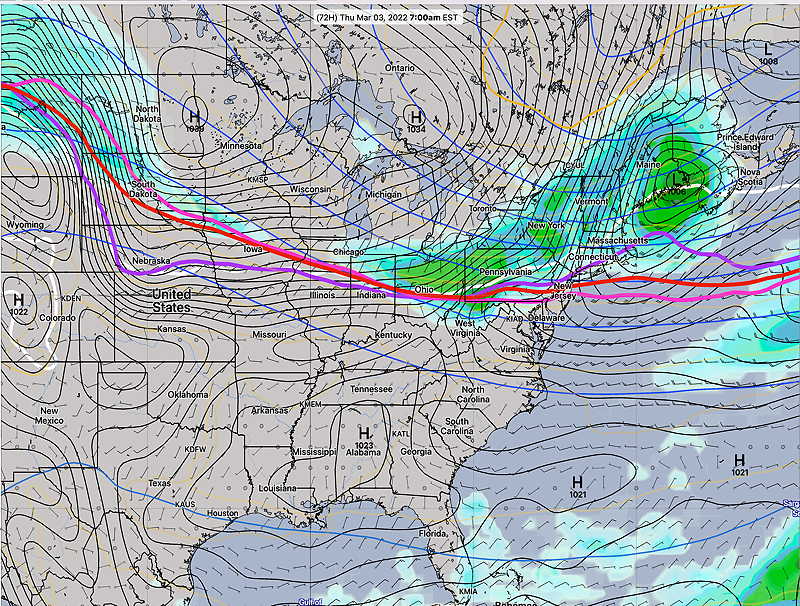
Update Thu @ 8:09 PM — Previous posts have indicated a warmup for the weekend as the jet flow becomes ridge-like over our area. The southwesterly flow will also bring moisture to our area in the form of clouds and some showers. There’s also the possibility of heavier rain next week.
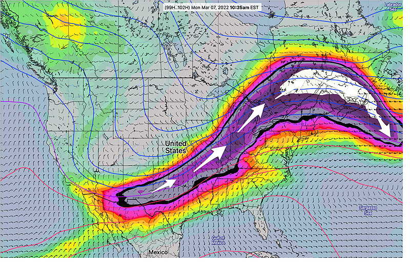
GEFS (mode) jet stream wind forecast (250mb) for Monday morning showing ridge over northeast. The white area is referred to as a “jet streak”, an area of increased wind speed, this case approaching 198 mph. Rising and falling motions (rain) occur at certain areas of the jet streak. (Click on image for a larger view.)
For Saturday, a warm front is expected to move through our area with significant cloudiness for much of the day. No rain expected.
For Sunday, there has been recent uncertainty regarding the speed and placement of showers on Sunday far ahead of a frontal system.
The ECMWF has been forecasting a period of rain Sunday morning with partial clearing in the later afternoon. It’s forecasting about 0.20 inches of rain.
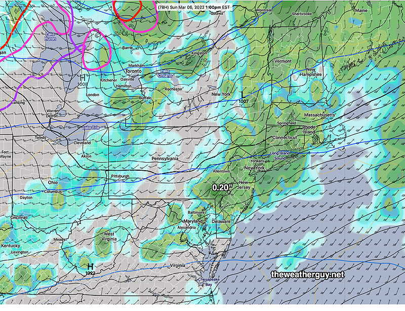
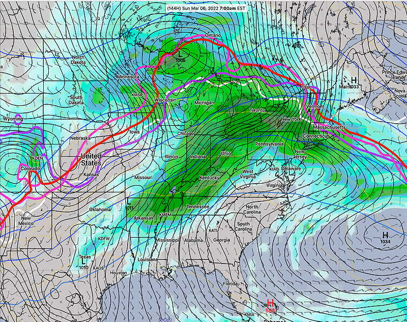
Today’s 12z ECMWF showing 3 hour rain accumulation at 1 PM Sunday. (Click on image for a larger view.)
The GFS has only a very light shower (< 0.02 inches) and mostly for areas north of the immediate Philadelphia area.
But today’s ICON and Canadian models have joined the ECMWF with the period of light rain in the morning. The NAM has also joined that group.
While ECMWF model is new to me (a limited but substantially increased data set only recently became available to the general public this past January 2022), I’m first learning its biases and tendencies and how to integrate its forecasts with the other main weather models like the GFS and NAM. As recently as last week though, a similar difference between the ECMWF and the GFS turned out in favor of the ECMWF forecast.
So with the ICON and Canadian RGEM leaning towards somewhat more rain, I’m leaning in that direction for Sunday. Most models have clouds thinning in the afternoon with temps in the 60s and WINDY conditions, although the latest GFS maintains a fair amount of cloudiness even in the afternoon.
Update Wed @ 10:30 PM — With the warming pattern expected this weekend, today’s models have quite a wide range of forecasts. There’s pretty good agreement for mostly cloudy conditions on Saturday, but not much agreement about whether we get rain on Sunday. The ECMWF and the GEFS show rain, the operational GFS, ICON and Canadian Global not so much. Too soon to know.
Update Tue @ 7:45 PM — Looking at today’s models, the warmup promised from a pattern transition to an upper air ridge still looks on track for the weekend.
Some showers possible late Wednesday night into Thursday morning, especially northern suburbs.
Saturday will be milder but may have considerable cloudiness. There’s a chance of sprinkles far north and west.
Sunday will be mild but some rain is likely.
That upper air ridge may be persistent with milder temps next week but several chances of rain.
Previously Posted Mon 4:59 PM —
It appears that we will have a quiet weather pattern this coming week.
The jet flow is expected to transition from the current colder trough pattern over the east —
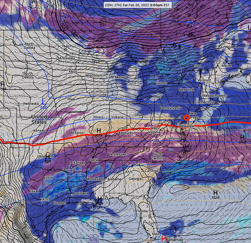
ECMWF forecast jet stream winds (300 mb level) for Thursday at 1 PM. A trough over the northeast with cold air. (Click on image for a larger view.)
to a ridge over the east by the weekend with warmer temperatures—
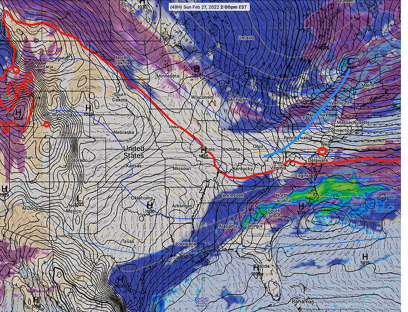
ECMWF jet stream forecast (300 mb winds) for Saturday at 7 PM. An upper ridge is expected to develop over the northeast. (Click on image for a larger view.)
During the week, several disturbances will pass by to our north, bringing some clouds and weak fronts. Here’s Thursday morning—
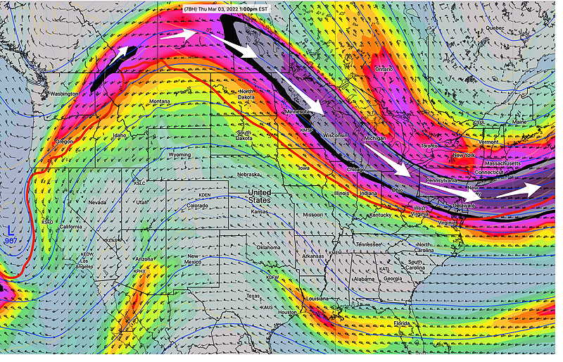
Today’s GEFS forecast for Thursday, showing some light rain barely making into our area, with the system passing to our north. (Click on image for a larger view.)
By the weekend the upper flow from the southwest will bring milder temperatures, but also considerable moisture and clouds, and possibly rain by Sunday.
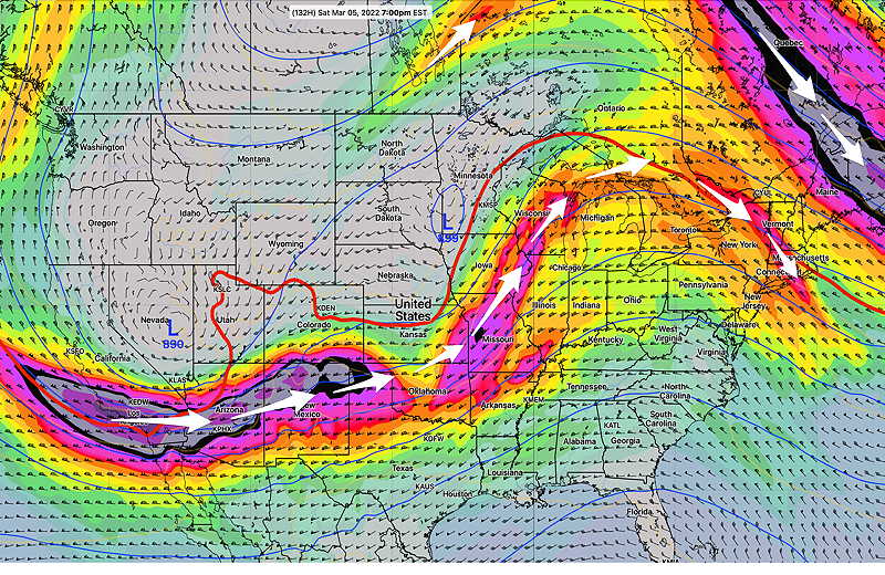
GEFS forecast for Sunday at 7 PM. There is some uncertainty about the timing of this system moving through. (Click on image for a larger view.)
Update Sat 10:30PM — The word for Sunday is WINDY. Gusts over 30mph during the afternoon.
Previously Posted Fri 5:59 PM —
A cold front moved through Friday and it has moved to our south. A strong jet stream will be positioned directly over us on Saturday. Upper air disturbances moving through the jet winds will result in cloudiness, especially in the afternoon.
(Average seasonal high temperature this time of year for Blue Bell is 47º.)
Clouds in the morning, breaking for sunshine, followed by some clouds in the afternoon. Update: Friday night’s models show much more sunshine Saturday afternoon.
Breezy
Cold. High temp 35.6º sd 2.1º (NBM model, Blue Bell)
This afternoon’s 18z GFS cloud forecast for 3 PM Saturday. Low clouds in dark blue. (Click on image for a larger view.)
On Sunday, low pressure developing along the front to our south will have some clouds spill up over our area in the morning, but with clearing for much of the afternoon as another cold front moves through later in the afternoon.
This afternoon’s 18z GFS cloud/radar forecast for Sunday at 2 PM. Low pressure off the coast will move east, away from us. (Click on image for a larger view.)
Sunday
Some mid-level cloudiness early, then mostly sunny.
Breezy becoming increasingly windy and gusty towards evening.
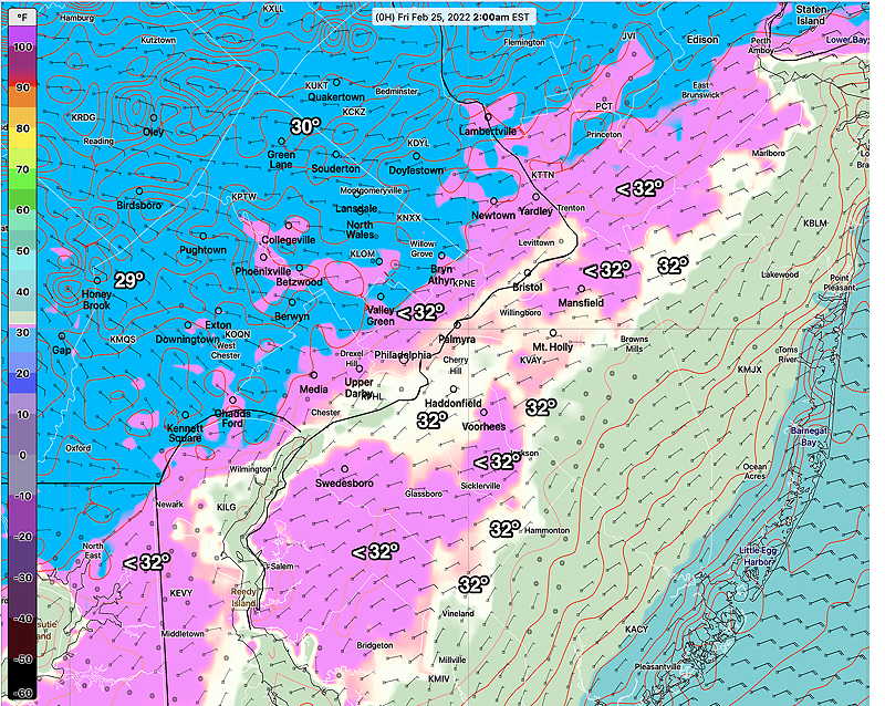
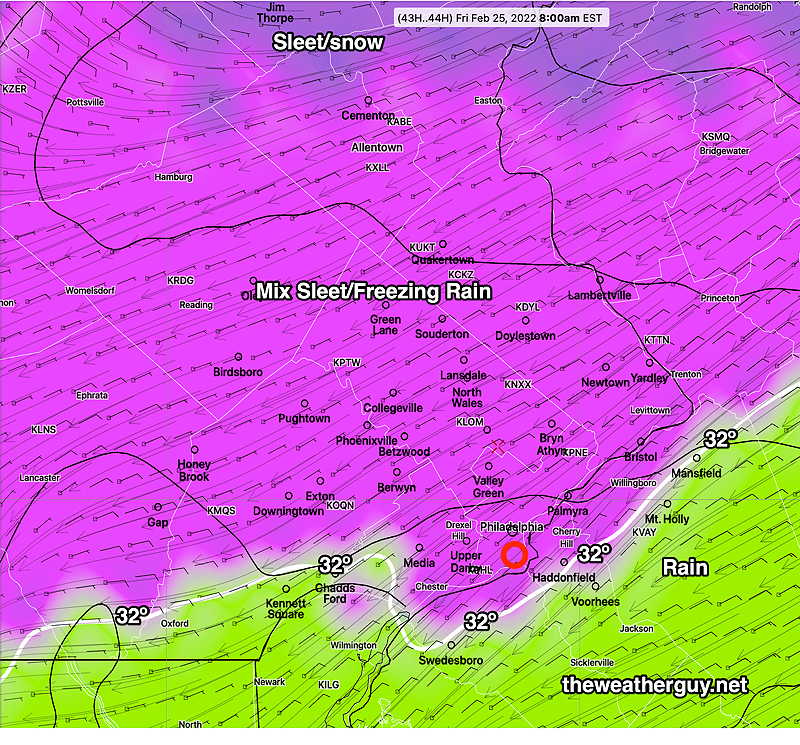
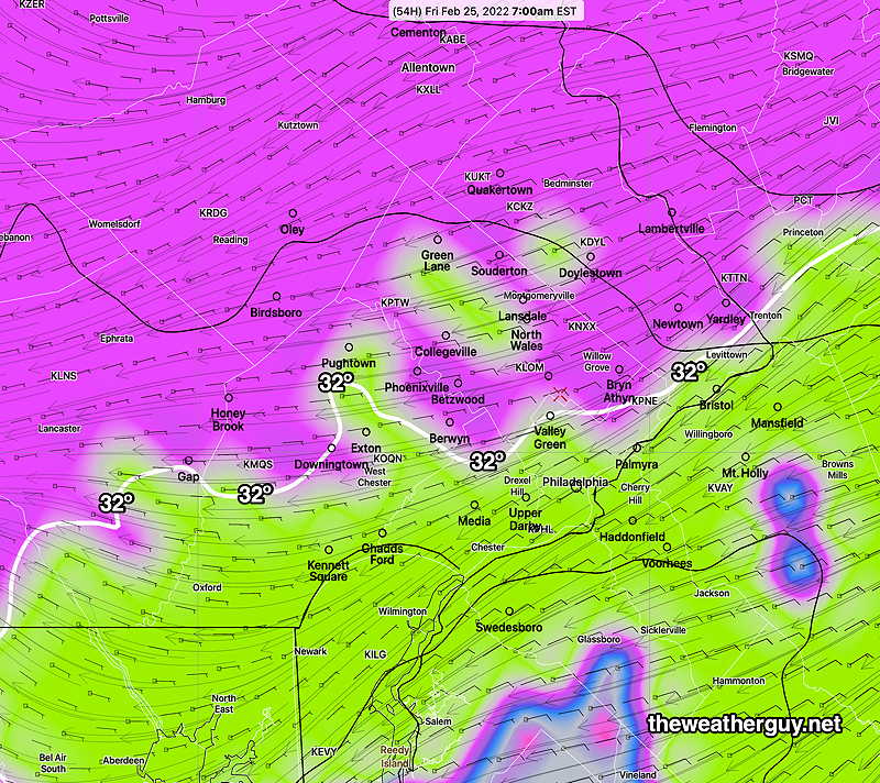
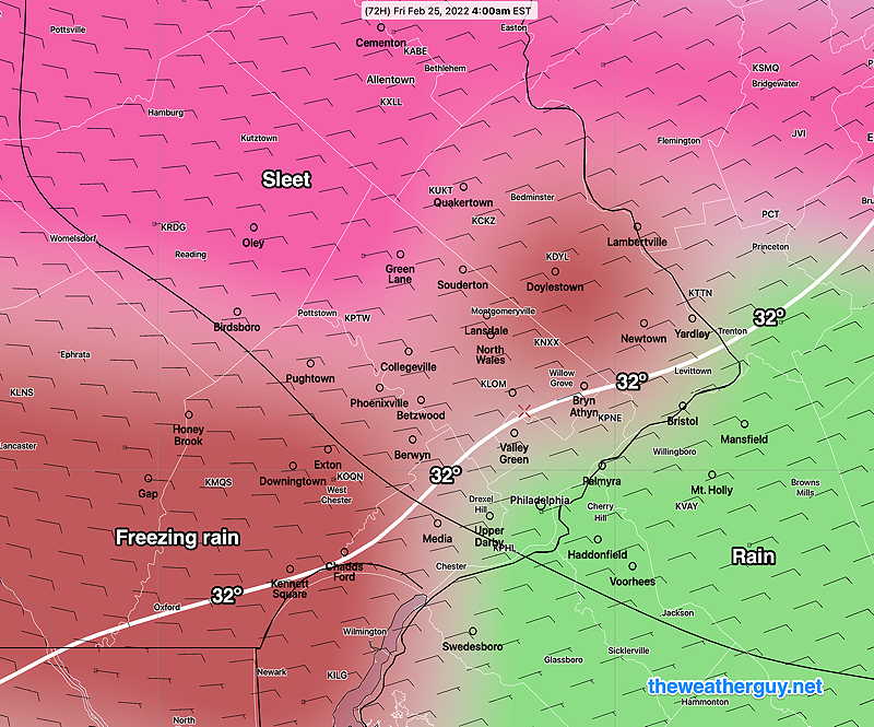
MIXED SLEET/FREEZING RAIN THURSDAY NIGHT CHANGING TO ALL RAIN BY MORNING
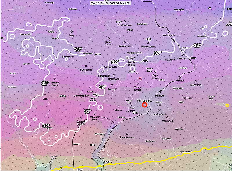
Fri 10:05 AM Forecast Review — So, we had even more ice accumulation than I would have guessed and temperatures did fall at or below freezing well into NJ, as forecast by last night’s NAM-NEST and HRRR. The URMA shows temperatures at 2 AM—
URMA from 2 AM Friday morning (URMA= “UnRestricted Mesoscale Analysis”) The URMA represents actual temperatures and conditions and is used for model verification. Since it represents corrected observations, the URMA is is released with a six hour delay to allow for corrected data input. (Click on image for a larger view.)
While the changeover to rain occurred, there was continued ice accretion past the rise in air temperatures above 32º. Most of the models over-predicted the rate of temperature rise. The major global models (GFS, ECMWF) never showed the temperatures drops into NJ.
Update Thu @ 9:55 PM — The precip is developing and moving in as forecast. Insignificant forecast changes with tonight’s models. Rain may linger until late morning.
Update Thu @ 5:54 PM — Here’s the latest trends based on today’s models. The trend is for some freezing precipitation to occur further southeastward than previously forecast (see image below). The changes are italicized:
The main area of precipitation, a mix of snow/sleet and freezing rain starts between 8 and 11 PM this evening. The heaviest frozen mixed precipitation will be between midnight and 2 AM.
Some areas north and west may have some accumulation/icy coating of frozen precipitation. The amount of precip falling in the frozen form may be as much as 0.3 inches water in northwestern areas.
The mix transitions to all rain in our area by 3-7 AM Friday morning.
Rain continues until mid morning, then ends.
Today’s 18z NAM-NEST precipitation type forecast 11 PM tonight. The 32º contour line is well into NJ. (Click on image for a larger view.)
Update Thu @ 9:27 AM — Here’s the latest trends which are consistent with last night’s forecast:
An area of light sleet or snow showers may move in during the afternoon, ahead of the main bolus of precipitation. (No accumulation expected.)
The main area of precipitation, a mix of snow/sleet and freezing rain starts between 8 and 11 PM this evening.
Some areas north and west may have some accumulation/icy coating of frozen precipitation. The amount of precip falling in the frozen form may be as much as 0.4 inches water in northwestern areas.
The mix transitions to all rain in our area by 4-7 AM Friday morning
Latest HRRR showing the greatest extent of the icy precipitation southward at 1 AM Friday. By 2 AM, the HRRR has the icy precip moving northward and all rain by 7 AM in our area.
This morning’s 12z HRRR showing the southeastern most extent of the its predicted frozen precip at 1 AM. (Click on image for a larger view.)
This morning’s NAM-NEST and HIRESW models are colder and have the extent of the mixed frozen precip falling as far southward as the Delaware River. I think the NAM-NEST may be too cold and I’m sticking with the HRRR forecast above. All models forecast a change to rain by 7AM.
Update Thu @ 8:02 AM — Last night’s models continue with a rapid warm up of the lower atmosphere between 3 and 5 AM. Any mixed icy precipitation will change to all rain by 7 AM in most of the immediate PHL area. The Canadian RGEM has joined the pack with a warmup.
Update Wed @ 9:25 PM — Tonight’s models have an area of mixed precipitation moving through in the early afternoon in advance of the main bolus later in the evening.
Update Wed @ 6:02 PM — Most of today’s models have continued with the following trend—
A mix of snow/sleet and freezing rain starts between 8 and 11 PM Thursday.
Some areas north and west may have some accumulation/icy coating of frozen precipitation. The amount of precip falling in the frozen form may be as much as 0.4 inches water.
The mix transitions to all rain in our area by 5-7 AM Friday morning.
The HRRR, NAM-NEST, HREF are on board with this warmup towards daybreak.
There’s one fly in the ointment: The Canadian RGEM (which has done the best with recent transitions from rain to snow behind cold fronts) is showing significant “cold air damming” and delayed transition to all rain. It shows freezing temps at 8 AM.
Here’s the latest RGEM forecast for 8 AM Friday—
Canadian RGEM forecast Precip Type 8 AM Friday. It has a much colder profile. (Click on image for a larger view.)
I’ll be interested to see if this trend holds and whether the RGEM had the right forecast.
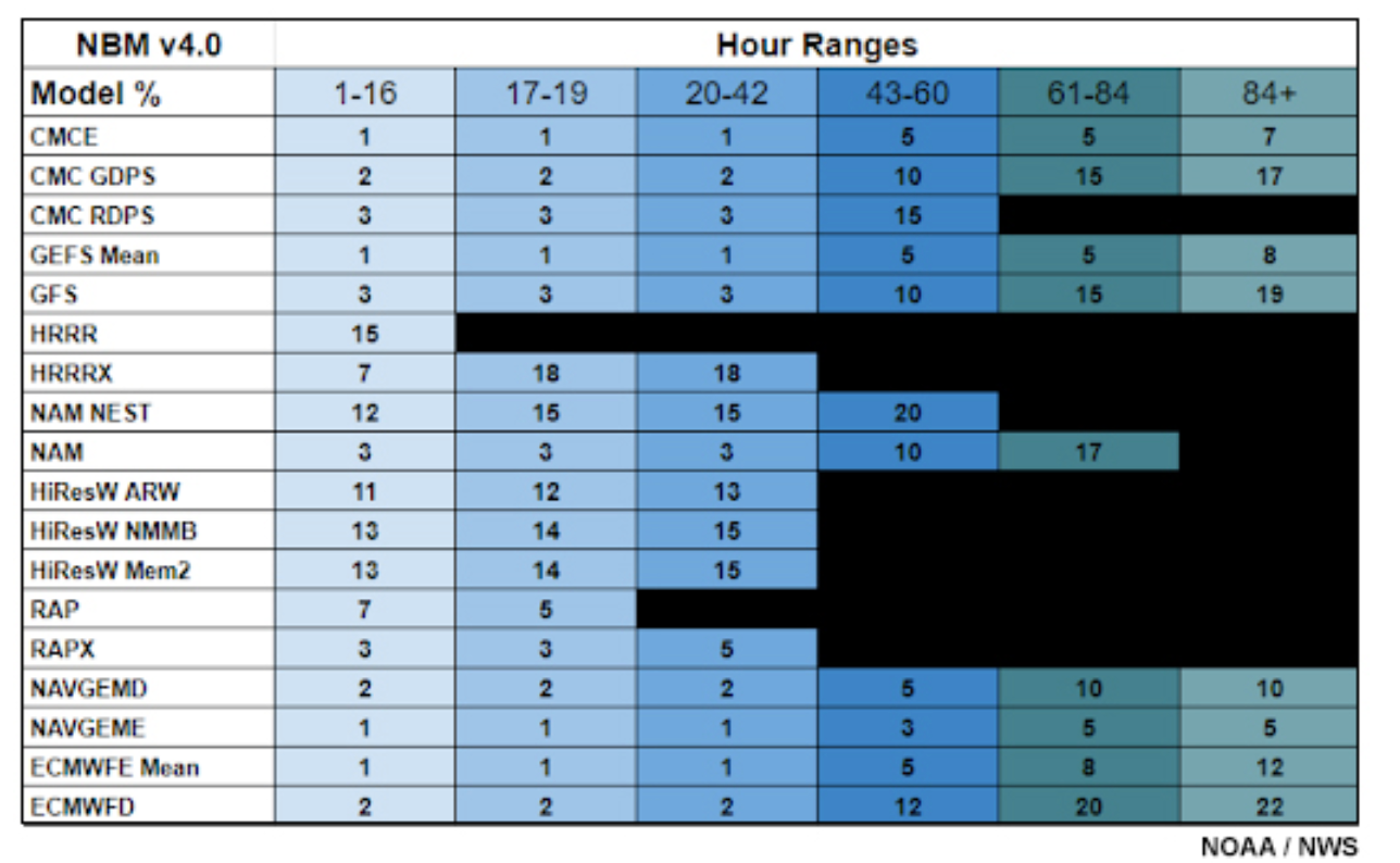
By the way, I recently came across a table that shows which models the NBM weighs more heavily in determining precipitation type (rain/snow/sleet/freezing rain)—
Model weights in percentage used by the National Blend of Models (NBM) for its determination of conditional probability of rain/freezing rain/sleet/snow. Note that it mostly uses the HRRR and NAM-NEST followed by the other HIRESW models. The Canadian RGEM is referred to by its other official name, the “CMC RDPS”. It isn’t weighted very highly, but the RGEM has been revised/updated subsequent to the NBM weighting being decided. (Click on image for a larger view.)
Update Wed @ 10:08 AM —The forecast period is now in the range of the higher resolution models. The concern about icy conditions early Friday morning appears to have somewhat abated as the latest models show less cold air at night and a more rapid warm up by daybreak Friday.
While the models are still predicting several hours of sleet mixed with rain in some of the area late Thursday evening into Thursday night, the trend has been to forecast a rapid increase in temperatures above freezing by daybreak Friday in much of the area.
The latest HRRR model and shows sleet and freezing rain at 1 AM in the northern and western suburbs. These same areas are ALL rain by 6 AM, according to the HRRR.
This morning’s 12z HRRR at 1 AM Friday morning showing sleet and freezing rain north of the 32º degree contour. This changes to ALL rain by 6 AM according to the HRRR. (Click on image for a larger view.)
I’m leaning towards the warmer HRRR.
The Canadian RGEM model (the model recently upgraded and improved in December) has done very well this year with cold front transitions of rain to snow. It has a colder, icier forecast, but still with a transition to rain about 7 AM close to the city—
Canadian RGEM forecast for 7 AM Friday. (Click on image for a larger view.)
I’ll continue to follow this…
Update Tue @ 8:40 PM —Today’s models show the following trends—
The models had trended colder this morning, but the afternoon’s runs have trended slightly warmer.
Most models have a wintry precipitation mix starting as sleet/rain between 7 PM and 10 PM Thursday evening.
(The NAM has some light sleet in the afternoon before the main slug of precipitation moves in during the evening.)
Temperatures in the immediate Philadelphia area do not support much if any ice accumulation on roads or other surfaces.
Most models have the sleet and any freezing rain changing over to plain rain in the immediate PHL area between 5 and 8 AM Friday.
Areas of concern are north and west of the 32º freezing surface temperatures (white contour)—
Tonight’s 00z NBM model precip forecast for 1 AM Friday morning. Most areas have mixed frozen rain/sleet mix at 1 AM Some snow north of Quakertown. Areas north of the 32º freezing line may have hazardous conditions from ice accumulation by daybreak. (Click on image for a larger view.)
I suspect things might change. I’ll update tomorrow
Update Tue @ 8:51 AM — Last night’s models continue with the forecast of sleet, freezing rain and rain mix for much of our area, starting Thursday evening and changing to rain Friday early to mid-morning, with a changeover delayed in far northern suburbs.
This morning’s 06zSREF showing precipitation type at 4 AM Thursday morning. (Click on image for a larger view.)
Some significant ice buildup is looking possible in northern and western suburbs by daybreak Friday. Stay tuned.
Update Mon @ 7:52 PM — The latest ICON model (below) shows the complexity of the storm expected to develop Thursday into Friday morning. Heavy precipitation is currently predicted by all models, especially far northern suburbs. The latest NBM and GEFS are trending warmer, which would reduce the chance of heavy ice or sleet buildup.
Today’s 18z ICON model shows low pressure developing along the coast at 1 AM Friday morning. A very complex system with multiple low pressure centers. The ICON shows significant precip with the temp at or below freezing from Philadelphia north and westward. (Click on image for a larger view.)
Update Mon @ 5:37 PM — A possible significant ice/sleet storm is setting up for late Thursday into Friday.
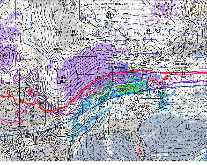
A cold front will move through the area Wednesday dropping our high temperatures back to near and below seasonal levels. The front will stall not far to our south. Cold high pressure will set up to our north behind this front, while the southern branch of the jet stream brings very moist air into the mix.
GFS forecast for Thursday 4 PM. Cold front boundary stalled through Virginia while cold high pressure is to our north. Moisture moving up over this stalled front will cause precipitation to fall through a cold air layer near the surface. Sleet and freezing rain expected. (Click on image for a larger view.)
This arrangement is referred to as a classic “cold air damming” setup — cold air remains at the surface and is slow to retreat due to strong high pressure to the north, while warm moist air forced to ride above the cold surface layer at 3000 -5000 feet causing mixed ice and sleet type precipitation.
The models are notoriously poor at predicting the warm up at the surface in these setups; they often predict warming too early, under-predicting the ice and freezing rain.
The latest NAM is fast with the sleet (and briefly snow) moving in. It has some frozen precip as early as Thursday afternoon.
Today’s 18z NAM forecast for Thursday at 4 PM. Significant area of sleet and freezing rain shown in our area.
Today’s ECMWF has significant precipitation falling in our area Thursday night while temperatures at the surface are below 32º. Not a good situation.
The current model blend (NBM) is warmer with temps above freezing, posing less of a threat for an ice storm in the immediate PHL area.
I’ll keep an eye this. Stay tuned.
Previously Posted Sun 4:54 PM —
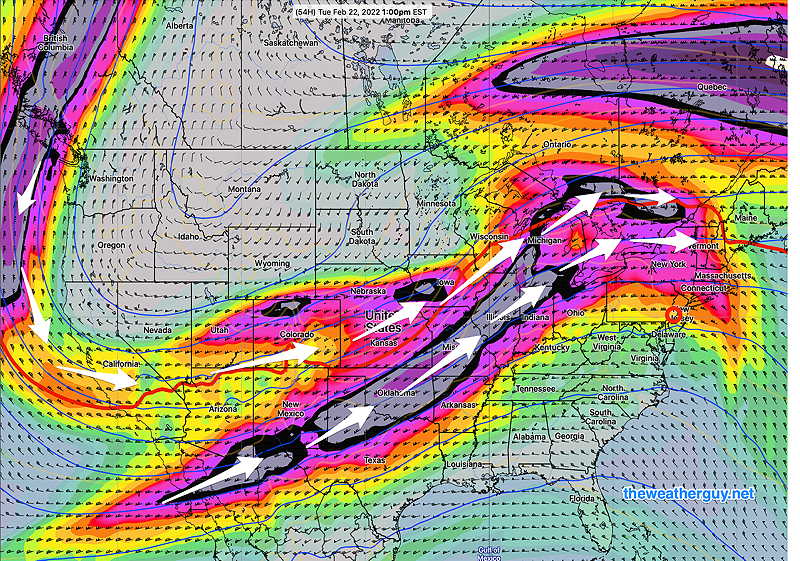
A warm up is expected Monday in advance of a moist southerly jet flow with rain on Tuesday as another deep low forms over the Great Lakes area in response to phasing northern and southern jet streams—
Today’s 12z ECMWF jet stream level winds (300 mb) showing strong flow from the south and phasing for a deep low over the Great Lakes on Tuesday. (Click on image for a larger view.)
Following rain on Tuesday, Wednesday will initially be mild temperature-wise, but somewhat colder air will filter in late Wednesday.
Another storm is expected late Thursday, although the timing is uncertain; some models have this next storm moving through Friday.
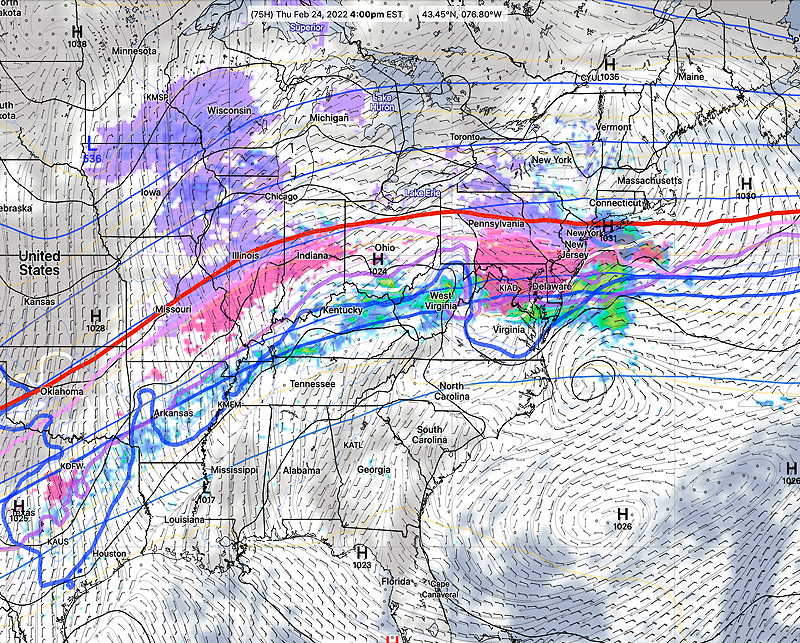
The Thursday/Friday storm will be rain for us, but the rain-snow line will not be that far to our north—
Today’s 12z ECMWF forecast for Friday 10 AM. (Click on image for a larger view.)