Update Sat @ 9:41 PM— Sunday’s forecast below looks good, It will be a little cooler ( high of 60°) than had been forecast and the instability cloudiness and the late afternoon sprinkles may be closer to Philadelphia..
Update Sat @ 9:01 AM— An updated meteogram is worth 1000 words—
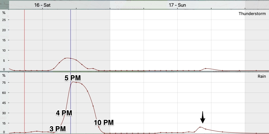
NBM09z meteorgram with forecast rain and thunderstorm hourly probabilities for Saturday afternoon. Thunderstorm probability is low. Blue Bell Pennsylvania (notice the chance of sprinkles Sunday afternoon about 4 PM (Click on image for a larger view.)
original post—
An autumnal dip in the jet stream will push a cold front through our area Saturday afternoon. Ahead of the frontal passage Saturday, expect gusty winds. Windy conditions will be with us for much of Sunday as well.
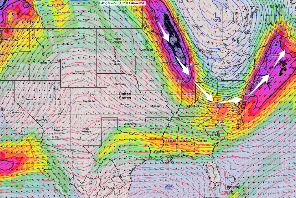
GFS forecast jetstream position on Sunday at 7 AM (Click on image for a larger view.)
Saturday
A cold front approaches from the west.
Some clouds in the early morning, then sunny and very mild, but windy.
Windy conditions with gusts increasing to 35 mph during the late morning and the afternoon. High temp 79º ± 1.6º NBM Blue Bell
Clouds move in from the west between 1 and 3 PM. Showers and thunderstorms are likely starting between 3 and 5 PM and ending about 10 PM.
High pressure builds in for Sunday, but cold air aloft may result in instability cloudiness.
Partly sunny with some instability cloudiness at times. Still gusty. Some widely scattered sprinkles possible in far northwest suburbs. High temp 62º ± 1.4º NBM Blue Bell
Incredibly our high temperatures today, Friday, and Saturday will be at or above 80°F.
Regarding Saturday, last night’s models continue their forecast of timing the surface frontal passage, based on wind shift and lowest barometric pressure, about 2 PM on Saturday.
Meteorologically, this will be an ‘anafront‘ and the models are showing that most of the rain and embedded thunderstorms will occur after the frontal passage. The model trend has been for the precipitation to occur somewhat later, now starting about 3:30 to 6 PM.
More information on this with my regular Weekend Weather Forecast this Friday evening.
Update Thu @ 7:25 PM—A cold front on will move across our area between 2 and 5 PM on Saturday. Today’s NBM model shows the possibility of some thunderstorm activity with and after the passage of the front.
As mentioned last night the main issue will be gusty winds. Total rain accumulation is not expected to be heavy with the front, although a brief heavy downpour might occur.
Meteorologically, this front is interesting in that it is what is known as an ‘anafront‘, where most of precipitation occurs behind the frontal passage. So the actual front moves through between 2 and 4 PM but much of the rain and possible thundershowers will move through it as late as 5 to 7 PM.
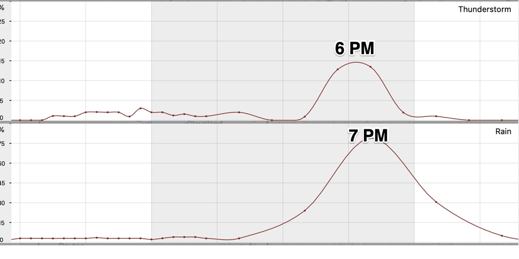
NBM peak rain and thunderstorm probability (Click on image for a larger view.)
Update Wed @ 8:14 PM— We will finally see some sun Thursday and Friday.
The models are in good agreement with a cold front moving through Saturday afternoon. The strongest dynamics with this front will be far north of our area, but the models are still forecasting some rain in our area.
The front will lower our temperatures closer to seasonal averages Saturday night into Monday. The main issue will be gusty winds on Saturday, peaking with the frontal passage. Current timing for the frontal passage is about 2 -4 PM Saturday. Windy/breezy conditions into Sunday.
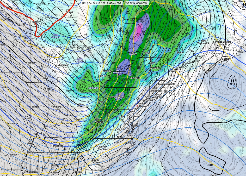
GFS Forecast for 2 PM Saturday. Front will be just to our west. (Click on image for a larger view.)
Update Tue @ 5:15 PM— Mild days through much of Saturday. A rather strong cold front moves through mid to late Saturday afternoon with showers and thunderstorms expected. Windy conditions on Saturday and into Sunday. Temperatures chill down on Sunday with low temperatures Sunday night as low as the upper 40s.
The low pressure system that affected our weather on Sunday will continue to linger off the coast. More clouds expected on Tuesday.
The coastal system will gradually move off by Wednesday, allowing an upper air ridge to bring in warm air to the Philadelphia area.
Unseasonably warm weather Wednesday through early Saturday.
GFS forecast for Wednesday 2 PM. An upper air ridge builds over our area as low pressure off the coast gradually moves away. Warm temperatures expected through Saturday. (Click on image for a larger view.)
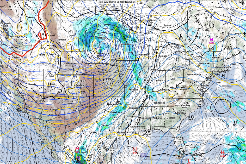
The GFS, Canadian GEM and ICON all show a cold front moving through. The current timing is Saturday afternoon. The models differ with the amount of showers/storms in our area. Here’s the GFS forecast for 2 PM Saturday—
GFS forecast Saturday 2 PM. Shower develop ahead of the cold front. Red line nosing down from Canada is the 540 thickness line, the general boundary between rain and snow where precipitation falls. That line stays well north of us, even after the cold front moves through. Blue lines are the “500 mb heights”. (Click on image for a larger view.)
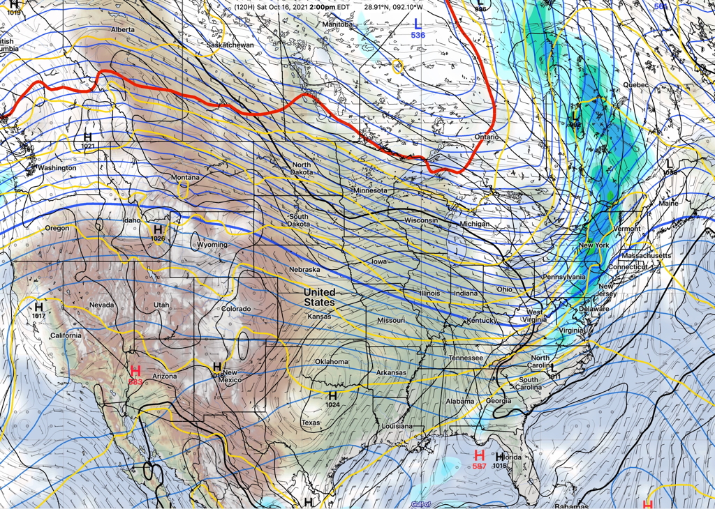
Despite a cold front passage, temperatures rebound by next week
GFS jet stream position next Monday. Another ridge is poised to move in—
GFS 250 mb winds and heights. Monday 2 PM (Click on image for a larger view.)
Sun 1:36 PM Forecast Review — Clearly, the phrase “relatively rain-free” was misguided on my part with Sunday’s forecast. And “relatively dry” was downright wrong.
As of 1 PM, PHL airport only reported 0.03 inches of rain. It certainly felt like a lot more than that.
I had wanted to distinguish my preference for the GFS forecast (~0.03”) from the other models which showed significantly more rain. If I had to do this forecast again, clearly “relatively rain-free” and certainly “relatively dry” were the wrong way to go.
Sat 9:00 PM—The latest GFS continues with a very cloudy but relatively rain-free Sunday.
This weekend’s forecast has been anything but straight-forward, as there have been huge differences in the major models for several days. I’ve put extra focus on Center City and the Philadelphia Broad Street Run forecast time frame.
Things are coming more into focus, with the Sunday period coming within the range of the higher resolution models. (Most models only have a forecast range of 48-84 hours, with the majority only 48-60 hours.)
Overview: High pressure over the North Atlantic will nudge down over us tonight as a back door cold front. An easterly flow will develop around this high pressure system. A coastal system with tropical characteristics will attempt to move up the coast, but will be blocked by the high pressure system.
Saturday
An easterly flow will develop over our area, bringing in moisture and clouds. The models differ with the amount drizzle, but several models have some bright spots in the morning, followed by low clouds and widely scattered areas of drizzle by afternoon. High temp 70.2º sd 1.8º NBM model, Blue Bell. Winds ENE 7-13 mph
Update Sat @ 10:01 AM This morning’s HRRR still shows some sun for Saturday afternoon.
Update: Fri 7:37 PM Friday night’s RAP and HRRR show showers before daybreak Saturday, then sunshine through high clouds Saturday morning into early afternoon. Then clouds move in during the mid to late afternoon. No rain, according to the RAP and HRRR during the day on Saturday.
Update: Friday’s GFS has some sunshine through high clouds Saturday afternoon. Not as cloudy as the other models.
The increasingly easterly flow around the high and the pressure gradient with the blocked low will result in some heavier drizzle and light rain Saturday night, mostly after midnight.
Sunday will be cloudy. The models continue to diverge with the amount of rain on Sunday. The GFS and GEFS have come somewhat closer together, with light rain/drizzle in the early morning before 8 AM, then tapering off during morning.
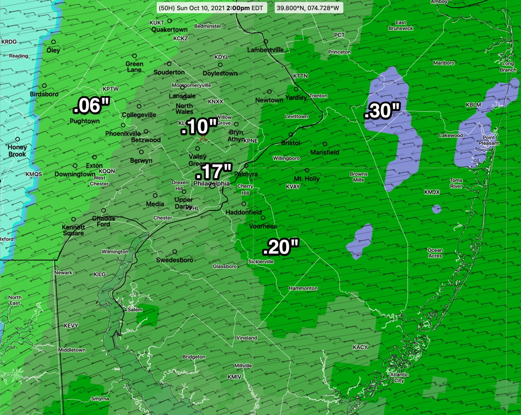
Total amounts of rain are light, regardless of the model. (The NBM has less than 0.17 inches for center City Philadelphia after 8 AM. ) The GFS and ICON continue with MUCH less, on the order of 0.03″.
High temp 69.7º sd 1.9º NBM model, Blue Bell. Winds light ENE with occasional gusts to 13 mph.
Sat 9:00 PM—The latest GFS continues with a very cloudy but relatively rain-free Sunday. There is still a low range of precipitation forecast by other models, but I continue to favor the GFS model’s very cloudy but relatively dry forecast.
Sat 8:51 AM— The latest GFS model from early Saturday morning (06z) continues with a relatively rain-free forecast for Sunday.
I’m leaning towards those GFS lower rain amounts after 8 AM.
NBM accumulated rain forecast for Sunday, starting at 8 AM. These amounts are likely too high, but it’s hard to ignore the NBM totals. The GFS and ICON models are showing much less rain. (Click on image for a larger view.)
(Heavier rain expected east, towards the Jersey Shore.)
The latest GFS (18z model run= 2 PM EDT) just became available as I post this. Still low amounts in Philadelphia.