WEEKEND WEATHER FORECAST

Sun 09:59 PM Forecast Review — The models did well with the forecast for the storms to diminish as they approached Philadephia Sunday evening.  
 

I’m trying to get past yesterday’s model forecast failure in the immediate Philadelphia area. Anthony Wood wrote a Philadelphia Inquirer article which mentions the forecast failure, but the expert he interviews provides an excuse, not any real answer, to explain the forecast failure. With so many models incorrectly forecasting heavy rain/storms in Philadelphia proper, the only thing I can postulate is there was some essential upper air data that was missing and/or systematically incorrect. But let’s move on…


Updated Saturday forecast, Fri 10:30 PM highlighted below
Updated Sunday forecast, Sat 8:30 AM highlighted below
Updated Sunday forecast, Sat 7:40 PM highlighted below
Updated Sunday forecast, Sat 11:40 AM highlighted below
Updated Sunday forecast, Sat 9:15 PM highlighted below

Current Water Vapor Image 4 PM Friday showing moisture not that far to our south. (Click on image for a larger view.)

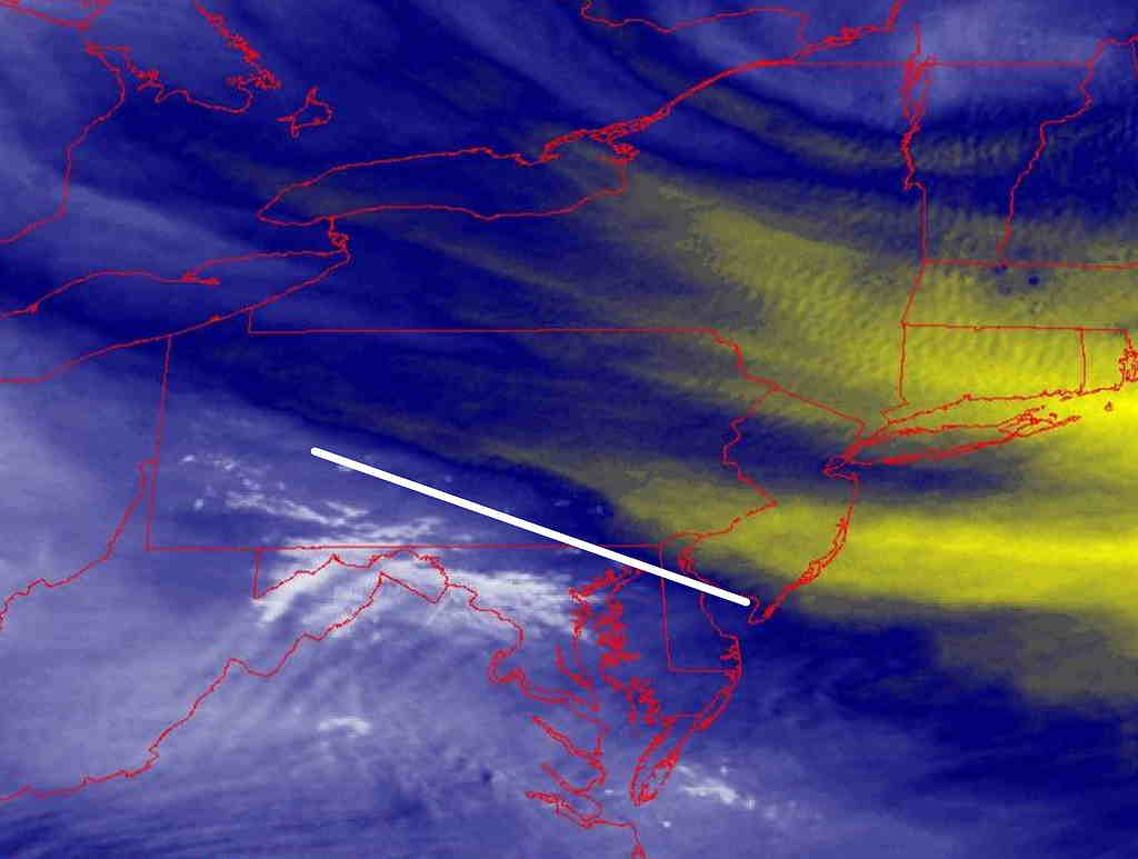
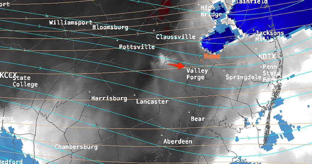
The front that moved through here Thursday is south of us, but the boundary isn’t that far south as shown on today’s water vapor image—

The cool air that’s with us on Friday will remain through Saturday, but aloft, warm humid air will try to return northward. Some cloudiness will develop as this moisture tries to return and will affect areas from the city southward according to the GFS. Any cloudiness dissipates by the afternoon. (The NBM has very little cloudiness.) Still a very nice day with high temperatures 78.7º ± 2.2º Blue Bell (NBM) and very low humidity.

Sunday’s weather will be influenced by a warm front, followed by a strong upper air disturbance with a cold front moving through Sunday evening.

Strong Upper air disturbance (1) moving southward push a cold front through Sunday night. GEFS model forecast for 2 AM Sunday (Click on image for a larger view.)

The warm front will continue to push from the south aloft. This will result in cloudiness and some scattered showers Sunday. The NBM has considerable showers, the GFS not so much.

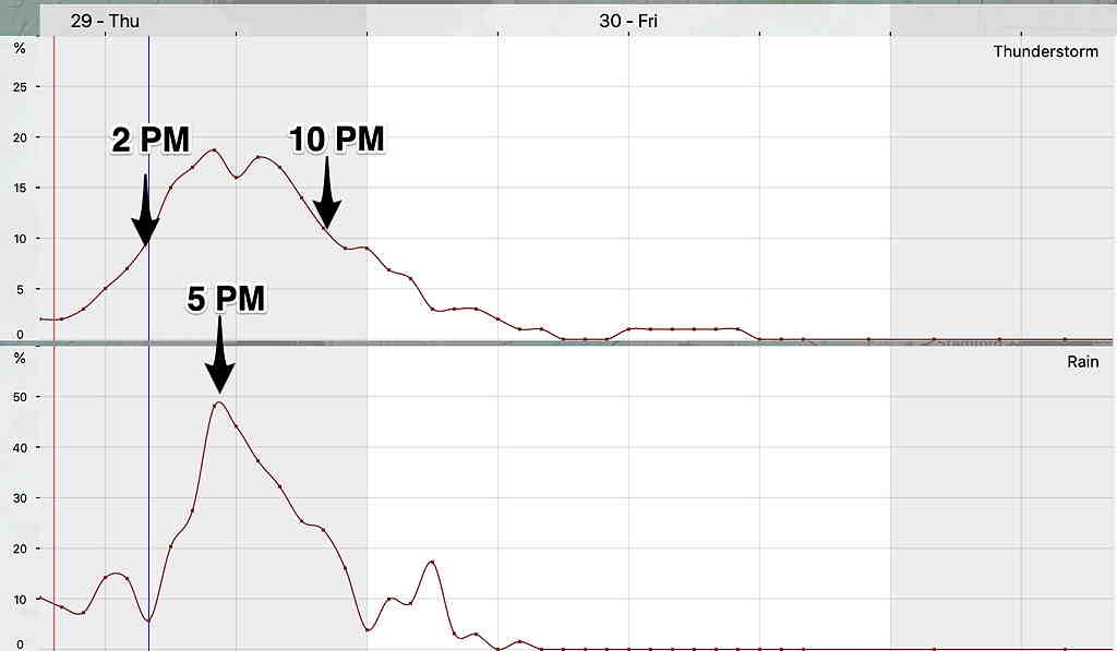
Update: Today’s GFS joins the other models with showers/thunderstorms for most of Sunday, starting during the morning and continuing through the afternoon as the warm front moves through. There may be a break in the action late afternoon. Additional showers/thunderstorms during the evening, about 9 PM.

Update: Most models have the line of thunderstorms Sunday evening weakening as it approaches Philadelphia from the west; they may not make it into the city or eastward.

At 9 15 PM, there hasn’t been much weakening of the line of storms. We’ll see what happens..

Update: The GFS maintains very little in the way of showers during the day. Any showers/thunderstorms in the evening will be mostly north and west of the city, less into Philadelphia. High temperatures 77.9º ± 3.3º Blue Bell (NBM) with higher humidity/dewpoints in low 60s.

As the cold front moves in Sunday evening, more showers and thunderstorms are likely. Current estimates are between 6-9 PM.

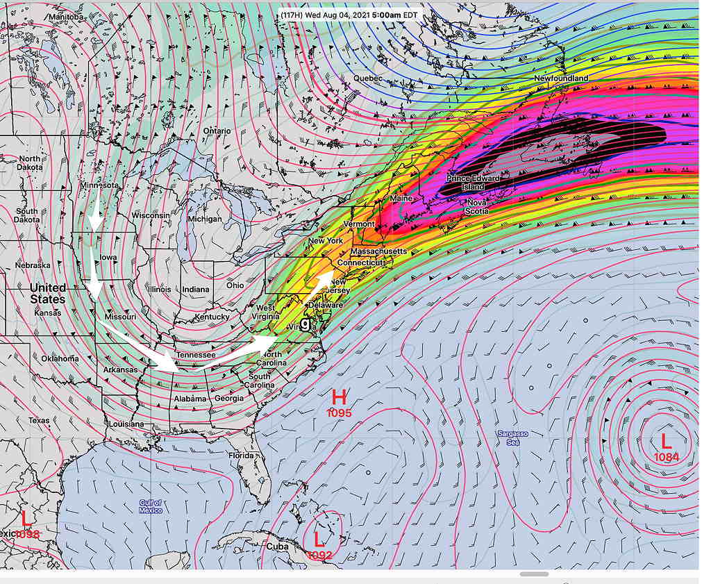
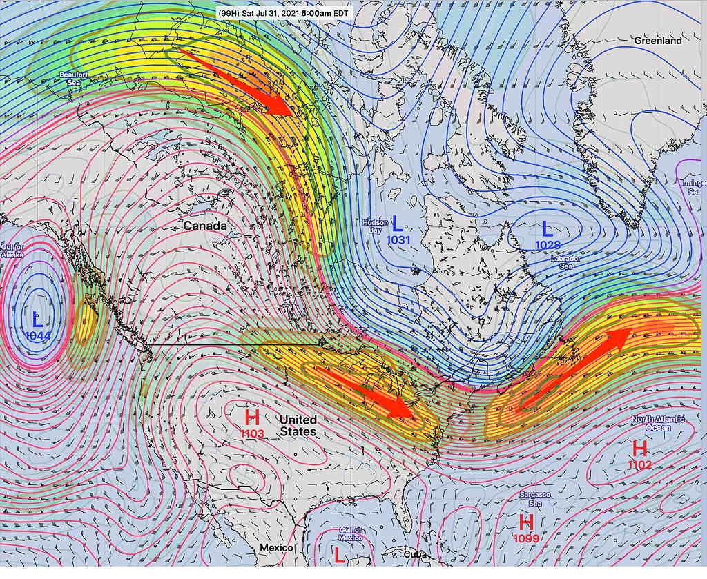
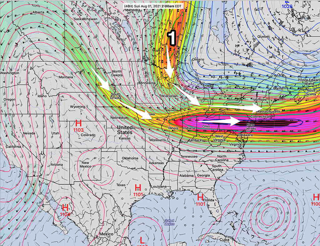
This upper air impulse (above graphic #1) will be the kicker for a very amplified jet flow next week. We’ll be on the cool side of things, but the amplification will spawn low pressure that, depending upon the exact track, may provide very unsettled and rainy conditions, especially by next Thursday.

GEFS Wednesday forecast showing VERY amplified jet flow for July. This will spawn low pressure. Exact placement to be determined. (Click on image for a larger view.)

THUNDERSTORMS THURSDAY

Thu 10:06 PM Forecast Review — Despite severe weather having broken out in Bucks county and central NJ in the expected time frame, I don’t consider today’s forecast a success.

The actual weather in Philadephia and most of the adjacent counties was far different than had been forecast by a multitude of models including the Canadian and German models.

Incredibly, the GFS (where convective activity is not its forte) did the best with timing and precipitation placement. Something to consider going forward.

Thu 07:30 PM Update — Severe weather has broken out in Bucks county and areas north and east into NJ.


Philadelphia, Delaware and Chester counties have not (yet) seen any severe weather.  In my neck of the woods, we haven’t had much of anything except for some rain earlier.  

Satellite water vapor imagery suggests something might be developing just to our west that may move within the next two hours.

Water Vapor Satellite imagery showing developing disturbance just to our west at 7:30 PM

Thu 05:06 PM Forecast Review — This is beginning to look like a bombed out severe weather  forecast, where only the GFS model (not known for its thunderstorm acumen) is correct. 


Last night’s 7 PM update mentioned that the GFS was downplaying the severity threat.  But, with all the high resolution models showing severe weather, I would never have just gone with the GFS for today’s forecast.  

Here’s the current radar which shows the heavier action going to our north and south.

MRMS precip image  4 PM.  (Click on image for a larger view.)

There’s still some time for the other models to redeem themselves.

Updated on Thu 3:31 PM: This morning’s GFS model with its earlier precip arrival and its less impressive, less severe weather may be on-target. The lack of sunshine this afternoon has kept a lid on some of the instability. I guess we’ll see.

Thu 12:34 PM Update — The latest GFS continues to be in it’s own camp with the main activity coming through about 3-6 PM.  I guess we’ll see.  
Thu 10:39 AM Update — The morning’s high resolution models are in (HIRESW, HRRR, NAM-NEST) .  Like the NBM meteogram just below,  they show two peak probabilities in rain/severe thunderstorms.  Rainfall will be very heavy, hail is possible along with damaging winds.  Helicity values are high enough to support the possibility of tornadic activity.  Any sunshine in the afternoon will assure more intense development. Peak times are 4-5 PM and 8-9 PM.
Thu 09:45 AM Update —This morning’s latest NBM ( 12z ) has the following timing for today’s storms—
NBM 12z  1 Hour probability  of thunderstorm and rain Meteogram for Blue Bell, PA (Click on image for a larger view.)

Thur 7:30 AM Update — Showers had broken out at the airport at 6 AM,  as predicted by last night’s HRRR.  Here’s the latest HREF meteogram for maximum simulated radar echo and the severe weather parameters, helicity and vertical shear.  The 5-7 PM timeframe is the time to watch. —
HREF meteogram (Blue Bell, PA) for simulated radar, helicity and vertical shear

Wed 09:58 PM Update — Tonight’s early models just becoming available. The latest HRRR still shows some impressive, severe thunderstorm parameters in the 5 PM to 7 PM time frame with gusty winds, hail, heavy rain and possible tornadic activity.


Tonight’s 00z NBM rain/thunderstorm meteogram for Blue Bell—

NBM 00z   (Click on image for a larger view.)


Wed 7:00 PM Update — The afternoon models just available have backed off on the magnitude of the severe weather parameters.  The GFS, in particular, has much of the activity moving through during the afternoon and early evening. This earlier afternoon activity appears to reduce the amount of sunshine and daytime heating resulting in lower instability CAPE and LI values and lower severity.  Helicity and shear parameters are coming in lower too.  The Canadian High Resolution model and Canadian GEM have strong storms 5-7 PM.   The peak time remains 4-7 PM, but as shown in the earlier posted NBM meteogram (below), some activity expected in the morning and early afternoon.
Wed 05:00 PM Update —I have used the words “strong”  and “very strong” to describe forecast thunderstorms this season.  I have rarely used the word “severe” this season. 


Tomorrow’s thunderstorm strength potential will likely fall into the severe category.  Some “severe weather” parameters are forecast to be the highest I’ve seen so far this summer season.  One parameter, “helicity” related to potential tornadic activity, is forecast to be substantially elevated at various times during the day.  Another parameter, “shear velocity”, is also highly elevated. 

Some of the other parameters that that have been elevated in previous storms this season  (CAPE, Lifted Index) are not as high as they’ve been previous thunderstorm days, so we’ll have to see how it all plays out. 

The latest HRRR suggests we might get some thunderstorms in the early morning (7 AM) , hinted at by the NBM.   The heaviest activity is likely between 4 PM-11 PM, but other activity is possible around noon or 1 PM. 

The general timing of all of Thursday’s storms is still best depicted by the NBM model meteogram posted below. 

Updated- Added 16z NBM meteogram

First, most of this morning’s (Wednesday’s) models have backed off on the thunderstorm potential for Wednesday afternoon and evening. Some models maintain a slight chance from just south of the city into Delaware and south Jersey.

Thursday looks to be much more active, as a strong cold front approaches and upper air disturbances move through in advance of the cold front.

A warm front moves through early Thursday morning. Several models forecast showers and thunderstorms early Thursday morning with this warm front.

Additional showers develop early afternoon and then again in the late afternoon and evening. Some of the dynamics may be very strong late Thursday afternoon, as the forecast jet stream energy has increased from previous model runs.

NBM model meteogram for Wednesday into Thursday thunderstorm probability & rain probability Blue Bell, PA. (Click on image for a larger view.)

The actual front moves through around midnight and before dawn Friday.

I’ll be updating later this afternoon and evening with more specific information. Stay tuned.