
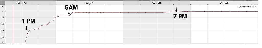
With a complicated forecast, let’s try a different approach. I’m going to use two different model’s meteograms showing precipitation for Blue Bell, PA. (remember that a meteogram only shows the weather for one specific location; the Jersey shore’s meteogram may look much different for the same time frame.)
Both show heavy rain (1 inch) starting about 2 PM Thursday afternoon.
The ICON shows significant rain again on Saturday. The model blend does not. (Not shown here, the GFS has showers in the late afternoon Saturday.) Both show Sunday and Monday essentially rain free.
ICON model—
Important clarification: the meteogram times indicate prior 1 hour accumulations. If you were to take those times as literal (and you shouldn’t), it would mean that the actual rain start times could have been as much as 1 hour earlier. Accumulation also does not show light rain that might not have accumulated enough to show in the scale of the meteogram.
NBM —
So after some heavy rain Thursday and early Friday, much of the Fourth of July weekend may be relatively rain free. (Considerable clouds on Saturday with possibly some showers in the afternoon, according to the GFS.)
Sunday and Monday look much better weather-wise.
It will be cool on Saturday (high in the 70s) and still below average highs on Sunday (about 80º)