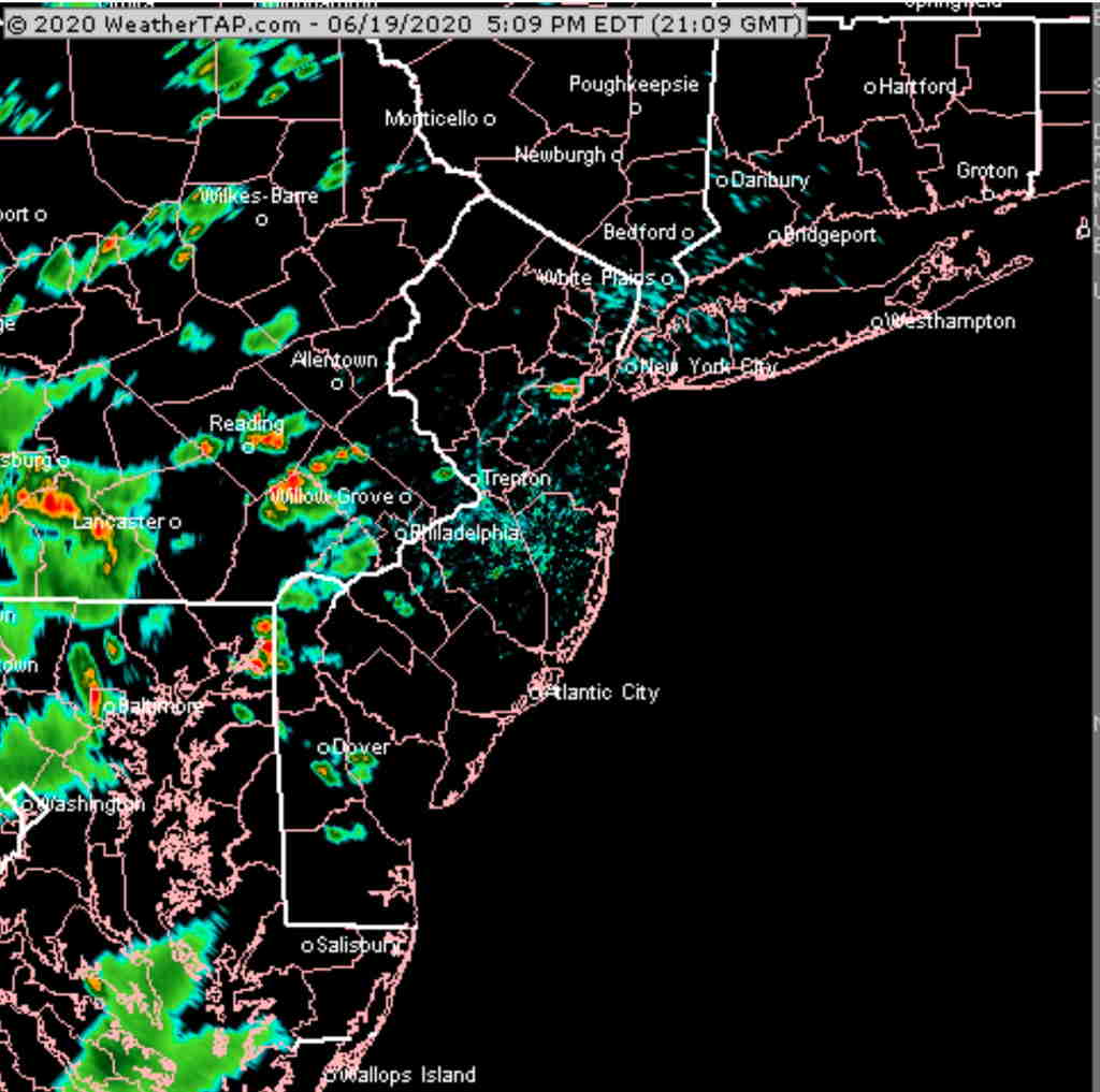
[su_note note_color=”#ffffff”]Updated Fri 05:14 PM — Here’s current radar at 5:09 PM. Showers usually don’t develop in the exact position predicted by the models.
Last night’s models continue with the idea that scattered thunderstorms are possible Friday afternoon and early evening. They will be scattered, but more widespread than my earlier forecast had suggested from last night.
Some possibility of very widely scattered (isolated) thunderstorms as early as 2 PM. A bit more widespread between 5 PM and 10 PM. Not everyone will get a thunderstorm.
(“Predicting thunderstorms is like trying to guess which spot in a saucepan is going to form the first bubble when heating water to a boil”.)
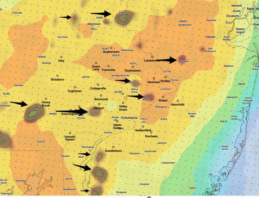
Here’s another approach to predicting thunderstorms: Upward Vertical Velocity (dark circles) combined with available energy (CAPE). The exact location of these areas is never exactly as shown.
HIREF (experimental) model 7PM CAPE with Vertical Velocity (Click on image for a larger view.)
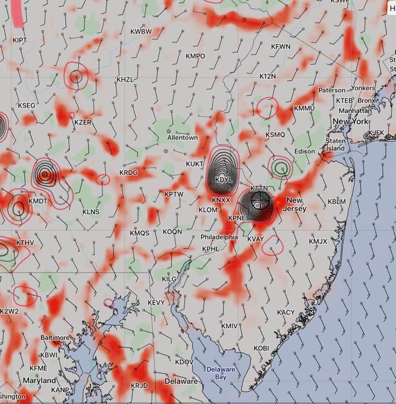
[su_note note_color=”#ffffff”]Updated Thurs 10:45 PM— Tonight’s HIRESW model just became available. It shows significant moisture convergence and vertical dynamics at 1 PM and again at 5 PM. This suggests showers/thunderstorms are possible around Philadelphia. The HIRESW has been doing well. This may negate the forecast below. I guess we’ll find out.
HIRESW model 5 PM moisture convergence (red) and vertical velocity (black)
[/su_note]
A broad upper cyclonic flow will replace the closed upper low on Friday. An area of moisture and clouds moves through mid day Friday.
So mostly sunny with a period of cloudiness Most areas will not have any showers on Friday. High 83.9° sd 1.8°. Dew points in the mid 60s.
Right now, the weekend is looking similar— increasingly warm and more humid. Most areas near Philadelphia won’t have any showers.
[su_note note_color=”#bceaed”]Forecast Review— We had additional showers this morning. Clouds did break in the afternoon. The HRRR model did poorly. Looking back, the HRESW and the NAM NEST were more on target. [/su_note]
The models have clearing skies from the southwest for Thursday. The predicted light showers we had earlier this morning appears to be all the showers most of us will have today.
The HRRR shows clouds dissipating by afternoon and most areas without any showers this afternoon.
HRRR model 3:30 PM forecast for cloud cover and precip (Click on image for a larger view.)
Updated Thu 10:10 AM — It’s somewhat of a low confidence forecast, since this is a change from last night’s model forecasts. Additionally, the HRRR doesn’t reflect the current radar situation.