PHILLY STORM UPDATE 9 AM

This morning’s NAM data just coming in. (Some data I depend upon won’t be available until about 9:40AM.)   Latest NAM has critical temperatures colder.  QPF still about 0.55 inches water during the daytime hours.  Precip ending by very early evening (5-7 PM)
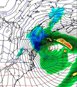
NAM 1PM Fri Forecast

Based on my usual forecasting criteria, I am still looking to a changeover and mix with wet snow by later this morning.  With all the mitigating factors still in play regarding accumulations (March solar insolation, above freezing air surface temperatures, etc.), it’s still impossible to give a snow accumulation total.    Some accumulation on grassy surfaces expected, a slushy wet coating on roadways if we get a burst of heavy precip .

Either way, it will be very stormy looking, despite minimal snow totals.

Highly unusual intense storm with blocked movement and a track that proceeds southeastward instead of the usual northeast track.

High winds a real concern, as sustained winds 25-35 mph with gusts near 55, especially during the afternoon hours.

[su_note note_color=”#ebf2d9″]9:50AM- Latest NAM FOUS data confirms the changeover to snow by noon or 1 PM.  Total QPF is about 0.69 inches water.  Some accumulation on grassy surfaces expected.  High winds![/su_note]

PHILLY STORM UPDATE – 7:30 AM

The 1AM model runs (06Z) show increased QPF for the hours now through about 6 PM- Over 1.0 inches water falling.

The secondary low pressure is developing south of Long Island, somewhat closer and westward, accounting for the increased QPF.   With the westward development, warmer air is predicted to intrude in the upper levels of the atmosphere at times during the day.  Critical temperatures remain warmer until about noon here in PHL, delaying the transition to snow.  Still expect snow to mix in but very uncertain about grassy accumulations.

I’ve been hanging my hat on the NAM model which has been a bit of an outlier, a somewhat colder forecast than some of the other models.   With these latest model run, the NAM is even a bit warmer, so I think the 2-4 inch grassy surface accumulation is wrong now.

Indeed, some of the short range models now show nothing accumulating around here.   I’m hard-pressed to give a number now.

(Indeed, the TV forecasters suddenly dropped any mention of snow accumulation in our area last night and went on the bandwagon with a high wind concern.)

Still expecting strong winds, especially in the afternoon.

The next model data becomes available about 9:45 AM this morning.   I’ll update then.

LATEST STORM UPDATE- 9:45 PM

The latest NAM data has become available. Following a rainy night tonight, storm intensification as previously predicted occurs as a secondary low pressure system winds up south of Long Island and moves southeastward.

Temperatures at critical levels of the atmosphere will become cold enough for snow as early as 7-10 AM, so the rain will transition to wet snow at that time.  QPF values as high as 0.70 inches water would ordinarily result in 7+ inches of snow, but for all the reasons enumerated in previous posts,  total accumulations will be much less and difficult to estimate.  Preferential grassy surface accumulations will still hold, with even less on paved and asphalt surfaces. Best guess is still 2-4 inches on grassy surfaces.

Strong winds develop during the afternoon on Friday, with highest winds during the afternoon. The HRRR model has  predicted wind gusts to be as high as 60mph! 

Snow ends about 7 pm.