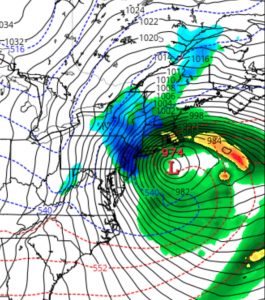
This morning’s NAM data just coming in. (Some data I depend upon won’t be available until about 9:40AM.) Latest NAM has critical temperatures colder. QPF still about 0.55 inches water during the daytime hours. Precip ending by very early evening (5-7 PM)

Based on my usual forecasting criteria, I am still looking to a changeover and mix with wet snow by later this morning. With all the mitigating factors still in play regarding accumulations (March solar insolation, above freezing air surface temperatures, etc.), it’s still impossible to give a snow accumulation total. Some accumulation on grassy surfaces expected, a slushy wet coating on roadways if we get a burst of heavy precip .
Either way, it will be very stormy looking, despite minimal snow totals.
Highly unusual intense storm with blocked movement and a track that proceeds southeastward instead of the usual northeast track.
High winds a real concern, as sustained winds 25-35 mph with gusts near 55, especially during the afternoon hours.
[su_note note_color=”#ebf2d9″]9:50AM- Latest NAM FOUS data confirms the changeover to snow by noon or 1 PM. Total QPF is about 0.69 inches water. Some accumulation on grassy surfaces expected. High winds![/su_note]

Wow everyone whiffed on this one and even the late forecasts seem to be coming up short. What happened?
I can’t speak for the other forecasters but for me, if I went by the numbers, we would have exactly what we got. I felt the March radiant energy and warm surfaces would over-ride the usual forecast snow amounts. As I said yesterday, if this would have been January, we would get 7+ inches, based on the numbers. So I was very reluctant to forecast snow totals based purely on the numbers; As a result, I felt I couldn’t give a snowfall estimate. Indeed, I felt I was going out on a limb predicting 2-4 inches in PHL.