Update Thu @ 7:25 PM — One more thought about the forecast gone wrong….. Most models got the onset timing correct and the end of the precipitation correct. They also got the general QPF (quantity of precip falling) correct. They went very wrong on the thermal profiles.
As for the weekend, as previously mentioned, the models have been in consistent agreement with the storm early Saturday staying to our south.
We’ll have very cold weather this weekend. High temps likely won’t exceed freezing. At times, there will be cloudiness due to an upper air trough moving through with additional weak cold fronts/upper air disturbances. Otherwise dry.
The next period of interest is Tuesday, where secondary low pressure may develop off of the coast. This period also has the potential to be a mixed-precipitation event with icy conditions or sleet. Just a possibility now.
Look for my regular, weekly “Weekend Weather Forecast” Friday afternoon or evening.
Thu 08:35 AM Forecast Review — So…most models got this forecast wrong. BUT there’s always something to be learned.
First, which models did the best here? As was the case a few weeks ago, the ICON and the new Canadian GEM model correctly predicted the temperatures warmer and more precipitation as rain.
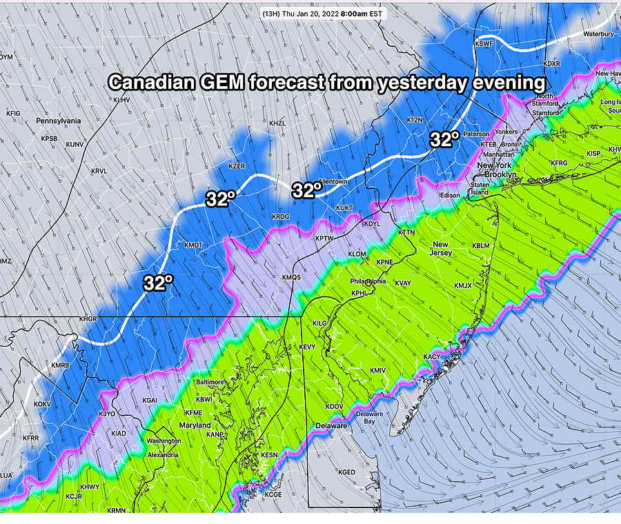
Canadian GEM model from Wednesday evening forecast for 8 AM today correctly predicted the above freezing temperatures and precipitation type being mostly rain (green) vs snow (blue). Note its 32º line is also closer to what we saw today. (Click on image for a larger view.)
Of our major models, the NAM and NAM-NEST were the closest.
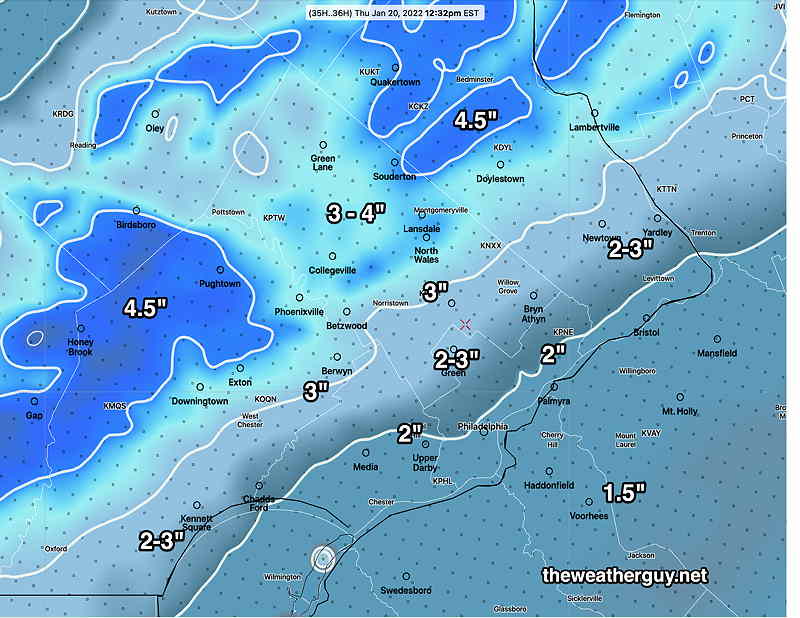
The HRRR, RAP, GFS, SREF, HIRESW and HREF groups had the 1-3″. Of course, since the NBM is a composite or ensemble model of other models, it steered its snow totals towards the greater population of high snow accumulation models. Our new GFS v 16 model has been very disappointing.
Another thing to learn with the NBM: the 25 percentile snow totals seems to be surprisingly accurate lately here. I have to admit, yours truly ignored the low-end NBM percentile and I discounted the warmer Canadian GEM and ICON as total outliers last night.
(BTW, last night’s ICON and GEM had predicted most of our precip as rain with just a coating possible.)
I may have to add to my mantra: “never ignore the NAM, GEM and ICON”
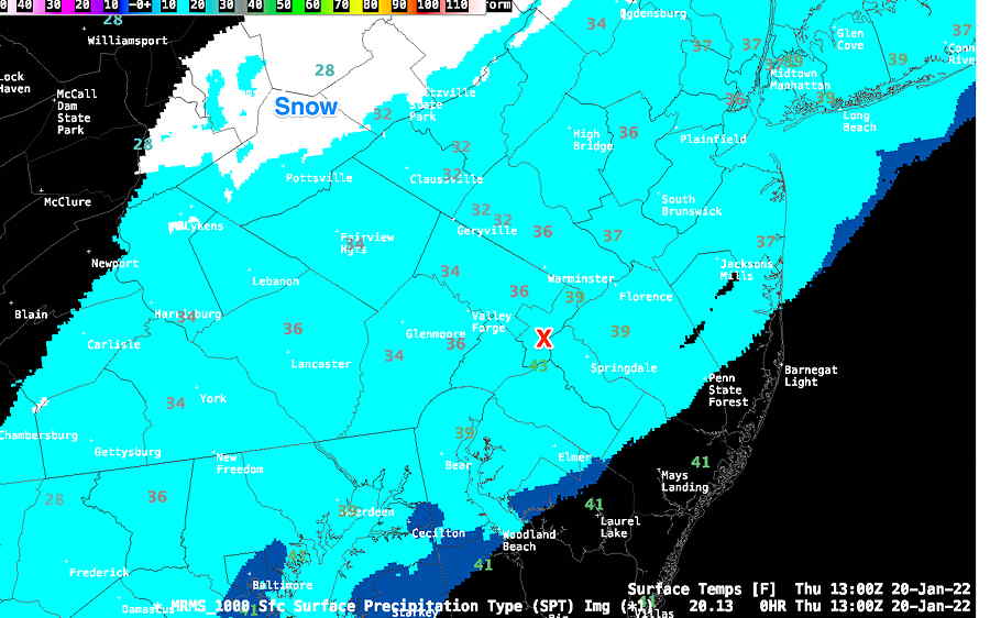
MRMS shows above freezing temperatures at 8 AM with snow far northwest. (Click on image for a larger view.)
Update Thu @ 7:41 AM — The latest HRRR 11z “Analysis” (the 0 starting hour for each hourly HRRR model run) just available shows why we’re still getting rain.
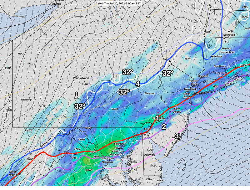
HRRR 11z (6 AM EST) analysis shows critical temperatures (1) (2) (3) all supporting snow here in Philadelphia, BUT important freezing temperature (Blue) at 975mb (about 2000 feet above ground) is still north of Allentown at 6 AM. Surface temp 32º white contour is at a similar location. (Click on image for a larger view.)
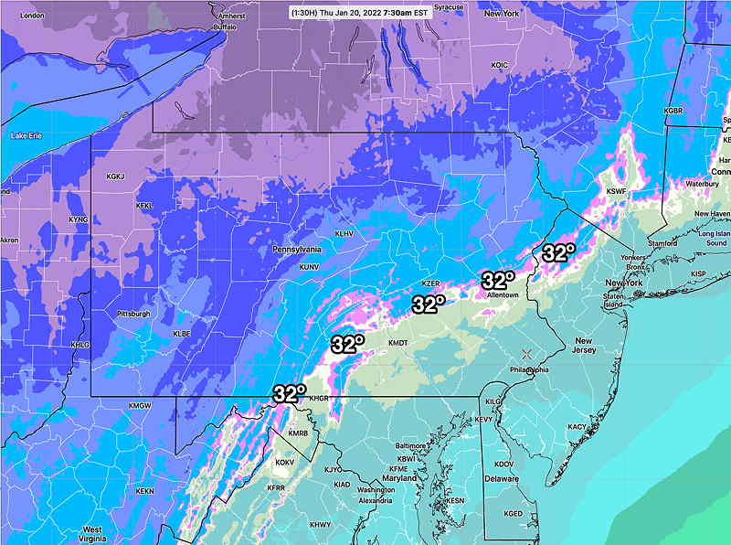
The latest real time RTMA analysis at 7:30 AM shows surface freezing temp still north of Allentown—
Update Thu @ 6:33 AM — Last night’s 00z and 06z Canadian GEM model runs joined the NAM with less than an inch of snow. Indeed these models had barely a coating for our area.
Last night’s ICON model was similar to the Canadian GEM.
Based on a comparison of actual conditions (the real time RTMA ) and other models, the NAM’s minimal snow forecast may be on the high side. So this morning, I’m leaning towards less than last night’s NAM model snow total graphic immediately below.
Update Wed @ 9:27 PM — Tonight’s early models have become available.
Rain about 3 AM with the arctic cold front passage will change to snow from northwest to southeast between 6 and 8 AM.
Snow continues until about noon.
Of interest is the trend of this afternoon’s NAM and the new NAM and NAM-NEST which just became available. It has less than an inch throughout the region. The reasons are:
The ground will start off wet.
The ground will be warm, above freezing, to start
Snow-water ratios will be low until it gets colder
Compaction of wet snow will occur initially
Latest NAM Model forecast (Click on image for a larger view.)
Regulars here know my mantra:“Never Ignore the NAM”
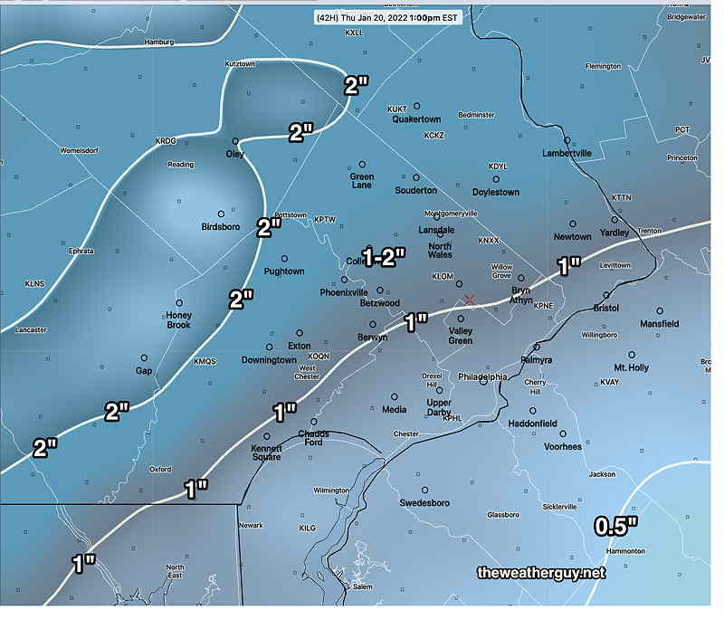
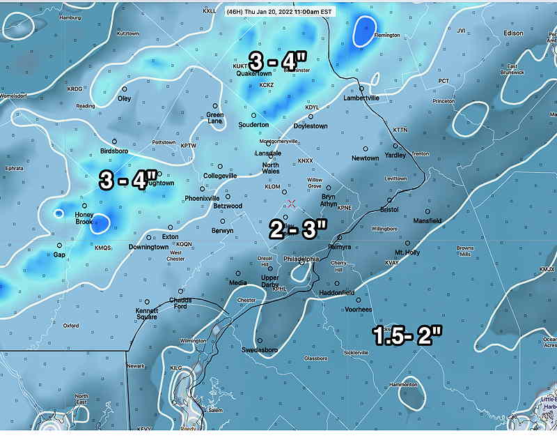
The latest NBM model is below and it captures most of the models forecasts from today. —
Important:the first number listed in the graphic’s snow total range is the most likely amount. (The second number in the range is a possible high amount.)
(Also note that 25% of the models that comprise the NBM had less than 0.8 inches, similar to the NAM!)
NBM snow totals for Thursday by 1 PM. First number in the range is the 50 (median) percentile. The second number is the 75th percentile. (Click on image for a larger view.)
My best guess is that snow totals will lie between the NAM and the lower first number of the NBM range.
Temperatures will drop into the 20s during the day and it will be windy. It will be cloudy until mid afternoon. What falls will freeze during the afternoon, especially areas not in the sun.
Update Wed @ 1:36 PM — This morning’s models continue with a similar forecast of a generalized 1-2 inches snowfall. The GFS has moved to a 1.5″ range for most of us. The next major model runs, the 00z runs, will start becoming available about about 9 PM. I’ll update around 9:30 PM. Stay tuned.
BTW, the models are currently in good agreement that the potential storm Friday into Saturday will move south of us, missing us here.
Update Wed @ 8:01 AM — The models run at 06z continue with a similar snow forecast for Thursday morning The differences in the model forecasts appear to be not based on the amount of precip falling (QPF), but rather how fast the temperatures drop and rain changes to snow after the frontal passage tomorrow. The Canadian GEM is the warmest, with snow just towards the end. It has the lowest snow totals, especially in the city, with just a coating to an 1/2”. The HRRR is the coldest and snowiest.
The GFS is predicting an overall 1” snowfall.
Since this will likely involve convective snow, the “convection-allowing models” referred to as CAM models may be the most accurate with this snowfall. The HRRR and NAM-NEST are CAM models.
HRRR—
HRRR 06z forecast (on the high end) (Click on image for a larger view.)
The Model Blend (NBM) is designed to do all the heavy lifting for predicting snow totals from all the model forecasts. Here’s the latest NBM—
NBM 06z snow totals by Tuesday 1 PM The amounts shown are the 50th and 75th percentiles. (Click on image for a larger view.)
At this time, the storm for Friday night into Saturday looks like it will miss us and move to our south.
Update Tue @ 10:19 PM — A quick update. Tonight’s models continue with a forecast of snow for Thursday morning. The models differ over what time the temperature drops to support snow.
The NAM (below) does a good job in the middle range. Some models support the previous HRRR model which has more snow.
NAM 00z model snow forecast Thursday. (Click on image for a larger view.)
Updates tomorrow.
Update Tue @ 5:23 PM — As mentionedbelow, the upper air configuration this week has many ingredients ripe for storm development. The triggers for such development are beginning to show in the upper flow. We may be affected by storms Thursday and again late Friday into Saturday.
Still much uncertainty, but it appears that Thursday morning, we’ll be clipped by a low pressure system that develops on the arctic front that moves through in the early morning. (see my morning update below.) The latest HRRR and NAM have moved to a quick 1-2 inch snowfall, starting daybreak Thursday and ending by noon.
The latest (18z) GFS stays with about 0.5 inches throughout the area.
The HRRR below is on the high end of the current forecasts—
HRRR 18z snow forecast for Thursday morning. Accumulations by noon. This forecast is currently on the high end of the range, with the NAM in the 1-2″ range where this HRRhas a 2-3″ range. (Click on image for a larger view.)
Below is the 18z Canadian Regional GEM model forecast, fairly close to the latest GFS and NBM—
Canadian Regional GEM model is similar to the latest GFS. (Click on image for a larger view.)
Another system is expected to follow Friday night into Saturday. There is a wide range of model forecasts about this second storm; it may move off to our south (according to the European ECMWF).
Updated Tue 12:01 PM — A quick look at the morning’s models shows most with about 0.5-1.5” snow accumulating Thursday morning with the higher amount northwest of the city. The NAM is on the lower end. “Never ignore the NAM”. Very cold temperatures after the frontal passage early Thursday.
Updated Tue 8:07 AM — Last night’s GFS suggests slight additional strengthening of Thursday morning’s low pressure system with a coating to an inch of snow here. The NAM does not show much of anything. Stay tuned.
GEFS 06z Bias-corrected MODE version forecast for Thursday 7 AM. Note considerable precipitation occurring north of the critical thickness lines (blue, violet, red) indicating precipitation will be snow. Approximately 0.5-2.0 ” suggested possible accumulation. NOT ALL MODELS ON BOARD WITH THIS FORECAST. (Click on image for a larger view.)
Previously Posted Mon 7:16 PM —
A broad upper air trough will remain established over the Central and Eastern US for the next week or so. Cold air pooling in eastern Canada and pushing southward will suppress the jet flow to our south.
We’re in the seasonally coldest portion of the winter. Average seasonal high temperatures are 40º (Blue Bell) and 41º (Philadelphia). With the exception of this Wednesday, temperatures will be below seasonal averages through next weekend.
With the cold air and upper cyclonic flow in place, many ingredients are in place for stormy weather. However, the current forecast is for the trough configuration to be positively tilted; there aren’t (yet) any identified upstream short wave triggers that might induce low pressure development.
Today’s GEFS 12z Model forecast for Thursday at 7 AM. Positively tilted trough hinted by 540 thickness line (red). High pressure is expected to build in following path (1) and low pressure (L) on the cold front that moved through may brush us with some light snow. If the high pressure system builds more southerly (2), a sharper trough may bring the snow closer, but currently not expected. Another impulse (3) may create a similar situation on Saturday, but much uncertainty with that system. (Click on image for a larger view.)
That said, a cold front comes through later Wednesday and there’s some suggestion that low pressure may develop to our south early Thursday. The models have us on the northern fringe of precipitation on Thursday morning and we may see some light rain changing to light snow Thursday.
Another impulse in the Gulf of Mexico may also slide to our south on Saturday. Again, we appear to be on the northern fringe.
In both cases, the currently forecast jet configuration is positively tilted and significant low pressure development near the coast is not currently forecast.
I’ll keep an eye on things. Check back during the week.